ATLAS of ANTIENT GEOGRAPHY by SAMUEL BUTLER 1843John McInnis Auctioneers,LLC4.6(502)See Sold PriceFeb 24, 2024
18TH C. ANTIQUE MAP: FRENCH & INDIAN WAR, FRAMEDThomaston Place Auction Galleries4.4(386)See Sold PriceFeb 24, 2024
Rand McNally Railroad Map Cabinet w/ 21 Railroad MapsRail & Road Auctions4.6(165)See Sold PriceMar 08, 2024
Keith Haring - Ink on New York Map, Best Buddies, Inscribed, Signed, and DatedSapphire Auction Gallery4(67)See Sold PriceMar 02, 2024
LATE 17TH C. FRENCH MAP OF THE NEW WORLD BY ALEXIS-HUBERT JAILLOT (1632-1712)Thomaston Place Auction Galleries4.4(386)See Sold PriceFeb 24, 2024
Central Railroad of New Jersey Map of Sandy Hook Route-ca. 1903JM Hobby Supply and Railroad Artifact Auctions4.4(126)See Sold PriceFeb 24, 2024
Lot of Six Mixed Atlas Box Cars-HO Scale-New in BoxJM Hobby Supply and Railroad Artifact Auctions4.4(126)See Sold PriceFeb 25, 2024
Rand McNally/Santa Fe Railroad Map of Iowa-1912JM Hobby Supply and Railroad Artifact Auctions4.4(126)See Sold PriceFeb 24, 2024
NICOLAES VISSCHER (NETHERLANDS, 1618-1709) MAP OF THE NEW WORLDThomaston Place Auction Galleries4.4(386)See Sold PriceFeb 24, 2024
17TH C. WORLD MAP BY NICOLAES VISSCHER (NETHERLANDS, 1618-1709)Thomaston Place Auction Galleries4.4(386)See Sold PriceFeb 24, 2024
Lot of Six Mixed Atlas Cabooses-HO Scale-New in BoxJM Hobby Supply and Railroad Artifact Auctions4.4(126)See Sold PriceFeb 25, 2024
MAP, Africa, De FerAfrica. Nicholas de Fer, L'Afrique Dressee Selon les Dernieres Relat. et Suivant les Nouvelles Decouvertes dont les Points Principaux sont Placez sur les Observations de Mrs. de l'Academie Royale desSee Sold Price
SoldAfrica.- Fer (Nicholas de) Partie Occidentale deAfrica.- Fer (Nicholas de) Partie Occidentale de l'Afrique ou se Trouve la Barbarie Divisee en Royaumes, map of the northwestern portion of Africa, from De Fer's Atlas Curieux, with Canary and Cape VeSee Sold Price
SoldDe Fer map of southern Africa c.1700Title: Partie Meridionale d'Afrique ou se Trouvent le Bassee Guinée, la Cafrerie, le Monoemugi, le Zanguebar et l'Isle de Madagascar Author:De Fer, Nicolas Description:Copper-engraved map. 21.5x31.8See Sold Price
Sold8 maps by De Fer, 1739-1740. Africa, Middle East.[Africa/Mideast] 8 maps by De Fer, 1739-1740. Most images approx. 8 x 10 in. Double-page. Includes: ++ Carte de la Coste d’Arabie Et Golfe de Perse… ++ Carte de la Coste Orientale d’Afrique DepuSee Sold Price
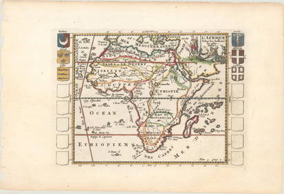
SoldL'Afrique Dressee selon les Dernieres Relations eAuthor: De Fer, Nicolas Copper-engraved map, hand-colored in outline. Engraved by H. van Loon. 46.5x59.5 cm. (18¼x23½"). Well-engraved and attractive map of Africa, filled with "legends" describingSee Sold Price
1730 Toms Map North East Africa -- Aegyptus etTitle/Content of Map: 1730 Toms Map North East Africa -- Aegyptus et Cyrenaica Date: 1730 c. Cartographer: W Toms Size: 8 x 11.9 in. This map, after Cluver and deFer, shows the Mediterranean coast froSee Sold Price
Toms: Antique Map North East Africa, 1730Title/Content of Map: 1730 Toms Map North East Africa -- Aegyptus et Cyrenaica Date Printed: 1730 c. Cartographer: W Toms Size: 8 x 11.9 in. This map, after Cluver and deFer, shows the Mediterranean cSee Sold Price
Toms: Antique Map North East Africa, 1730Title/Content of Map: 1730 Toms Map North East Africa -- Aegyptus et Cyrenaica Date Printed: 1730 c. Cartographer: W Toms Size: 8 x 11.9 in. This map, after Cluver and deFer, shows the Mediterranean cSee Sold Price
1730 Toms Map North East Africa -- Aegyptus etTitle/Content of Map: 1730 Toms Map North East Africa -- Aegyptus et Cyrenaica Date: 1730 c. Cartographer: W Toms Size: 8 x 11.9 in. This map, after Cluver and deFer, shows the Mediterranean coast froSee Sold Price
1730 Toms Map North East Africa -- Aegyptus et CyrenaicaTitle: 1730 Toms Map North East Africa -- Aegyptus et Cyrenaica Cartographer: W Toms Year / Place: 1730 c. Map Dimension (in.): 8 x 11.9 in. This map, after Cluver and deFer, shows the Mediterranean cSee Sold Price
1730 Toms Map North East Africa -- Aegyptus etTitle/Content of Map: 1730 Toms Map North East Africa -- Aegyptus et Cyrenaica Date: 1730 c. Cartographer: W Toms Size: 8 x 11.9 in. This map, after Cluver and deFer, shows the Mediterranean coast froSee Sold Price
1730 Toms Map North East Africa -- Aegyptus etTitle/Content of Map: 1730 Toms Map North East Africa -- Aegyptus et Cyrenaica1730 c. Cartographer: W Toms Size: 8 x 11.9 in. This map, after Cluver and deFer, shows the Mediterranean coast from the RSee Sold Price
1730 Toms Map North East Africa -- Aegyptus etTitle/Content of Map: 1730 Toms Map North East Africa -- Aegyptus et Cyrenaica Cartographer: W Toms Year/Place: 1730 c. Size: 8 x 11.9 in. This map, after Cluver and deFer, shows the Mediterranean coaSee Sold Price
1730 Toms Map North East Africa -- Aegyptus etTitle/Content of Map: 1730 Toms Map North East Africa -- Aegyptus et Cyrenaica Date: 1730 c. Cartographer: W Toms Size: 8 x 11.9 in. This map, after Cluver and deFer, shows the Mediterranean coast froSee Sold Price
1730 Toms Map North East Africa -- Aegyptus etTitle/Content of Map: 1730 Toms Map North East Africa -- Aegyptus et Cyrenaica Date Printed: 1730 c. Cartographer: W Toms Size: 8 x 11.9 in. This map, after Cluver and deFer, shows the Mediterranean cSee Sold Price
1730 Toms Map North East Africa -- Aegyptus etTitle: 1730 Toms Map North East Africa -- Aegyptus et Cyrenaica Date: 1730 c. Medium: W Toms Size: 8 x 11.9 in. Additional Information: This map, after Cluver and deFer, shows the Mediterranean coastSee Sold Price
1730 Toms Map North East Africa -- Aegyptus etReserve Reduced! Title/Content of Map: 1730 Toms Map North East Africa -- Aegyptus et Cyrenaica Date: 1730 c. Cartographer: W Toms Size: 8 x 11.9 in. This map, after Cluver and deFer, shows the MediteSee Sold Price
1730 Toms Map North East Africa -- Aegyptus etTitle: 1730 Toms Map North East Africa -- Aegyptus et Cyrenaica Cartographer: W Toms Year / Place: 1730 c. Map Dimension (in.): 8 x 11.9 in. This map, after Cluver and deFer, shows the Mediterranean cSee Sold Price
SoldFAFR Fer (Nicolas de)FAFR Fer (Nicolas de) L'Afrique Divisée Selon l'Etendue de Ses Principal Parties, large wall map of Africa, bordered with decorative vignette scenes, animals and costume figures, titleSee Sold Price
SoldDe Fer Map/View of Cape of Good Hope 1705Title: Cap de Bonne Esperance Author:De Fer, Nicolas Description:Copper-engraved map/view. 25x35 cm. (9¾x13¾"). The Cape of Good Hope at the southern tip of Africa, with a view at the top of Table MSee Sold Price
Sold[Map] De Fer, North & South America, 1717Nicolas de Fer - "L'Amerique, Meridionale et Septentrionale" (Paris: the Author, 1717) engraving, 9 X 13 1/4 in., plus margins (Interestingly, the only line of longitude is inscribed as passing over "See Sold Price
SoldMAPS - DE FER, N[icolas]. Mappe-Monde ou Carte GéMAPS - DE FER, N[icolas]. Mappe-Monde ou Carte Générale de la Terre. Paris: Chez l'Auteur, dans l'Isle du Palais à la Sphere Royale, 1717. Copper-engraved double-hemisphere world map (380 x 26See Sold Price
Soldde Fer: 1705 Southern Italy with Sardinia InsetTitle/Content of Map: de Fer: 1705 Southern Italy with Sardinia Inset Date Printed: 1705, Paris Cartographer: de Fer Size: 13" x 8 1/2" The Kingdom of Naples map from de Fer's L'Atlas Curieux, featuriSee Sold Price
de Fer: 1705 Kingdom of Naples with Sardinia InsetTitle/Content of Map: de Fer: 1705 Kingdom of Naples with Sardinia Inset Date Printed: 1705, Paris Cartographer: de Fer Size: 13" x 8 1/2" The Kingdom of Naples map from de Fer's L'Atlas Curieux, featSee Sold Price
Railways & Transport.- [Prospectus] The Dorking, Brighton, and Arundel Atmospheric Railway, byForum Auctions4.3(52)See Sold PriceFeb 29, 2024
Carte de la Barbarie… l'empire de Maroc… North Africa Morocco. LAPIE 1829 mapJasper524.5(9.8k)See Sold PriceFeb 28, 2024
AFRICA. French West Africa. Rio de Oro Rio Muni Nigeria. BARTHOLOMEW 1952 mapJasper524.5(9.8k)See Sold PriceFeb 28, 2024
COLONIAL GABON & CONGO. Afrique équatoriale française. Brazzaville plan 1929 mapJasper524.5(9.8k)See Sold PriceFeb 28, 2024
La Barbarie de la Nigritie et de la Guinée'. West Africa. DE L’ISLE 1745 mapJasper524.5(9.8k)See Sold PriceFeb 28, 2024
Le Canal de Mosambique, l'Isle de Madagascar… Mozambique. Africa. BONNE 1788 mapJasper524.5(9.8k)See Sold PriceFeb 28, 2024
Le Canal de Mosambique, l'Isle de Madagascar… Mozambique. Africa. BONNE 1790 mapJasper524.5(9.8k)See Sold PriceFeb 28, 2024
COLONIAL GABON & CONGO. Afrique équatoriale française. Brazzaville plan 1938 mapJasper524.5(9.8k)See Sold PriceFeb 28, 2024
L'Afrique Françoise ou du Senegal'. French West Africa. DE L’ISLE 1727 mapJasper524.5(9.8k)See Sold PriceFeb 28, 2024


![[Map] De Fer, North & South America, 1717 (1 of 1)](https://p1.liveauctioneers.com/523/81971/42494504_1_x.jpg?height=282&quality=70&version=1447274451)
![MAPS - DE FER, N[icolas]. Mappe-Monde ou Carte Gé (1 of 1)](https://p1.liveauctioneers.com/839/16941/5653171_1_x.jpg?height=282&quality=70&version=1221072577)


![Railways & Transport.- [Prospectus] The Dorking, Brighton, and Arundel Atmospheric Railway, by (1 of 1)](https://p1.liveauctioneers.com/5458/319736/171654703_1_x.jpg?height=282&quality=70&version=1708010439)