Map, 18th c., by John Speede,Map, 18th c., by John Speede, atlas page of Somersetshire (England), under glass, DOA 17.75"h x 24"wSee Sold Price
SoldCollection (12) antique maps by Speede and othersCollection (12) antique maps by Speede and others, 17th/18th c., many provincial maps of Britain, makers include John Norden, John Speede, etc., smallest: 15.5" x 21.5 (sight), largest: 19.75" x 23.75See Sold Price
Sold1610 John Speede Engraved Antique Map Of Surrey17th C John Speede Map Of Surrey. Surrey Described And Divided Into Hundreds' By John Speed Dated 1610. Includes View Of Richmont And Nonsuch Castles. London And The Thames Are Visible In The Upper PaSee Sold Price
SoldJohn Ogiley hand-colored map- 18th c.John Ogiley- ''The Road From Oxford to Coventry- hand-colored map, fold down center as should be, some staining and foxing throughout. 15 x 18''See Sold Price
Sold18thc Map of Asia, John Senex, EnglandFramed English hand-colored engraved map by John Senex "A New Map of Asia" TITLE: A New Map of Asia from the latest Observations Most Humbly Inscrib'd to the Right Honbl. George Earl of Warrington & cSee Sold Price
SoldJOHN ROCQUE (ENGLAND, 18TH C.) SURVEY MAP OF PARISDATED 1854 WITH UPPER LEGEND. ON LINEN. 21.5"X29.5"See Sold Price
SoldJohn Speede (1552-1629) British. "Canaan", Coloured MapJohn Speede (1552-1629) British. "Canaan", Coloured Map c.1611, 15" x 20".See Sold Price
SoldMap of Denbighshire, John Speede, 17th C.Map of Denbighshire, John Speede, 17th Century, handcolored, 16" x 21 1/2". Old restoration on left side.See Sold Price
SoldMap: An 18thC double glazed hand coloured road stripMap: An 18thC double glazed hand coloured road strip map of the City of Oxford, with the Road from Oxford to Bristol verso, published in John Owen & Emanuel Bowen's Britannia Depicta or Ogilby Improv'See Sold Price
Sold18th c. "Map of the Southern States of America,"18th c. "Map of the Southern States of America,"copperplate engraving by John Russell, from THE AMERICAN ATLAS (London: H. D. Symonds, 1795-95), shown are Maryland, Virginia, the Carolinas, Georgia, KSee Sold Price
Sold18th c. Map of America- Emanuel Bowen18th c. Map- ''A New and Accurate Map of America''- engraved map, 1748, from John Harris- ''Complete Collection of Voyages and Travels'', short repaired separation at top of centerfold. 14 3/8 x 17 5/See Sold Price
Sold18th C Map of Florence, Hand Colored EngravingFramed 18th century map of Florence, hand colored engraving. Provenance: John's Island, Vero Beach, Florida.See Sold Price
Sold1799 Map ITALY JOHN CARY "A New Map of Piedmont" 18th CA beautifully engraved and colored 18th Century map of Italy. This piece is entitled: "A New Map of Piedmon the Duchies of Savoy and Milan; and the Republic of Genoa; with their Subdivisions." EngraveSee Sold Price
18th c. Map of the Southern States of America18th c. ''Map of the Southern States of America,'', engraving by John Russell, 1795, from the ''American Atlas'' (London H. D. Symonds, 1795-95), mended 3 inch tear on right side, narrow right marginsSee Sold Price
Sold(4) Framed Antiques Prints(2) Depicting the Boston State and Custom House and (2) (18th c.) Maps of England. 6 x 8 inches and smaller Condition: GoodSee Sold Price
SoldMap Early 18th Century "A New Map of the World",Most Humbly Inscribed to his Royal Highness George Prince of Wales", by John Senex, c.1721, from the New General Atlas of the World, handcoloured etching, framed, 42cm x 52cmSee Sold Price
Sold18th C. Hand-Colored Map of New EnglandAn 18th C. hand-colored engraved map of New England, Nova Scotia, New France, or Canada, with the Islands of Newfoundland, Cape Breton, St. John's, by Jacques-Nicholas Bellin. Framed under glass. MatSee Sold Price
Sold18th c. French MapFramed 18th c. steel engraved & colored 18 1/4" x 23 3/4" "A New Map of France" by John Senex, 19 1/2" x 25 1/4" overall size framed.See Sold Price
Sold18th C. Engraved Map of "Anglesey"18th century, engraved map of "Anglesey", by John Speed, 15 1/2"h x 20 1/2"w (sight).See Sold Price
SoldThree 18th C. U.S. Maps, inc. SouthernThree (3) French and Indian War period maps. 1st item: John Gibson: THE BRITISH GOVERNMENT IN NORTH AMERICA, Laid Down Agreeable To The Proclamation of Oct. 7, 1763. Published in The Gentleman's MagazSee Sold Price
SoldLOT (3) INCLUDING HAND COLORED COPPER ENGRAVED MAPLOT (3) INCLUDING HAND COLORED COPPER ENGRAVED MAP, JOHN SPEEDE, A COAT OF ARMS AND A MAP OF WESTPHALIA, 17/18TH CENTURYSee Sold Price
SoldMAP OF SPAIN AND PORTUGALThe map dedicated to Duke John L. Somers, 18th C. Plate Size: 25 x 36 1/2 in (63.5 x 92.7 cm). Paper Size: 27 x 37 1/2 in (68.6 x 95.3 cm).See Sold Price
SoldH/C MAP HUNTINGTON TO IPSWICH BY JOHN OGILBYH/C MAP HUNTINGTON TO IPSWICH BY JOHN OGILBY COSMOGRAPHER 18TH C, SIGHT 13" X 18"See Sold Price
SoldCOLORED PRINT, MAP OF THE NEW CONTINENT, J. GIBSONFramed colored print on paper, "A Map of the New Continent", J. Gibson sculpt. (John Gibson, British,18th c.), sight: 8.5"h, 7"w, overall: 17"h, 15.5"w, 3.25lbs Start Price: $80.00See Sold Price
EARLY WALL CLOCK WITH "EDMONDS LONDON" FUSEE MOVEMENTThomaston Place Auction Galleries4.4(393)See Sold PriceFeb 24, 2024
EARLY 18TH C. MAP OF ITALY, FRAMEDThomaston Place Auction Galleries4.4(393)See Sold PriceFeb 24, 2024
17TH C. MAP OF THE BERKSHIRES BY JOHN SPEED, FRAMEDThomaston Place Auction Galleries4.4(393)See Sold PriceFeb 24, 2024
18TH C. ANTIQUE MAP: FRENCH & INDIAN WAR, FRAMEDThomaston Place Auction Galleries4.4(393)See Sold PriceFeb 24, 2024
PAIR (18th c) OF FLINTLOCK DUELING PISTOLSJohn McInnis Auctioneers,LLC4.5(505)See Sold PriceFeb 24, 2024
(18th c) ENGLISH BOOK-MATCHED CHEST OF DRAWERSJohn McInnis Auctioneers,LLC4.5(505)See Sold PriceFeb 24, 2024
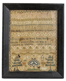
(18th c) SAMPLER by SARAH BROWN born 1780.John McInnis Auctioneers,LLC4.5(505)See Sold PriceFeb 25, 2024
Two (2) Antique 18th C. Copper Engraved Framed Maps - America & EuropeMagnusson Art Group4.5(53)See Sold PriceMar 14, 2024
An 18thC longcase clock by John Steel Killamarsh, Derbyshire. The brass face with engraved silveredClaydon Auctioneers Ltd4.3(125)See Sold PriceFeb 26, 2024
Map: An 18thC engraved and hand coloured map of Buckinghamshire after Robert Morden. Approx. 8 1/4"Claydon Auctioneers Ltd4.3(125)See Sold PriceFeb 26, 2024
Map: An 18thC engraved and hand coloured map of Northamptonshire, with description ofClaydon Auctioneers Ltd4.3(125)See Sold PriceFeb 26, 2024
Map: An 18thC engraved and hand coloured map of North America and South America, titled DeClaydon Auctioneers Ltd4.3(125)See Sold PriceFeb 26, 2024
Map: An 18thC engraved map of Bedfordshire titled An Accurate Map of the County of Bedford DividedClaydon Auctioneers Ltd4.3(125)See Sold PriceFeb 26, 2024
Map: An 18thC engraved map titled A New and Improved Map of Oxfordshire.. after Thomas Kitchin.Claydon Auctioneers Ltd4.3(125)See Sold PriceFeb 26, 2024