SoldManuscript pocket map of ChihuahuaBARCHESQUIL, Enrique Mapa Del Estado de Chihuahua.[Mexico, after 1854]. Pen and ink manuscript folding pocket map, hand-colored in outline (19 1/2 x 14 3/4 inches, 500x375 mm). Sectioned andSee Sold Price
Sold(E.B.) To Mesopotamia and Kurdistan in Disguise, nSoane (E.B.) To Mesopotamia and Kurdistan in Disguise, newspaper obituary tipped to title, 1912 § Field Notes. Mesopotamia, folding map and manuscript notes in pocket at beginning, folding tabSee Sold Price
SoldThe Tourist's Pocket Map of the State of Virginia[Virginia] THE TOURIST’S POCKET MAP OF THE STATE OF VIRGINIA Exhibiting its Internal Improvements Roads Distances &c. by J. H. Young. Philadelphia: Published by Thomas Cowperthwait & Co., 1851. (PubSee Sold Price
SoldManuscript map of northern Mideast/ SE Europe.[Manuscript Map]. Middle East and southeastern Europe, emphasizing the coastlines of the eastern Mediterranean, the Black Sea, and the northernmost portion of the Red Sea. Cartouche and all labels onSee Sold Price
SoldEarly Chinese Language Grand Format Manuscript MapEarly Chinese Language Grand Format Manuscript Map of China circa 1800 (date uncertain). Hand coloring on mulberry paper. Blank on verso. May be a copy of Ming period map. Measures 49x35''. Very goodSee Sold Price
Sold1857 Phelps pocket map of United StatesPhelps National Map of the United States, A Travellers Guide, Embracing the Principal Railroads, Canals, Steamboat & Stage Routes Throughout the Union, published by Ensign, Bridgman, Fanning, 1857. FoSee Sold Price
Smith Pocket Map of United States, 1848Cartographer: Smith & Son Year/Place of Publishing: 1848 New York 1848 Smith Pocket Map of United States -- A New Map for Travelers through the United States of America, Showing the Railroads, CanalsSee Sold Price
SoldS. Farmer's 1872 Pocket Map of Lake SuperiorFull title being: Farmer's Map of Lake Superior and the Mining Regions, showing Geological Formations, Mines, Mining Lands, Lakes, Marshes, Hills, Roads, Rail Roads, Towns, and Villages with historicaSee Sold Price
SoldRare Bolton 1873 Pocket Map of Copper DistrictFull title being: Portion of the Copper District Michigan Lake Superior 1873. Published by Geo. D. Bolton, Calumet, Mich. This fine and rare hand colored pocket map is on polished paper and is 20 x 29See Sold Price
SoldPocket Map of Greater New York 1898Pocket Map of Greater New York 1898 Compliments of The Eureka Fire Hose Co., 13 Barclay Street, New York City. Very Good Condition for its age. Cover has a couple dings to it but the map is very nice.See Sold Price
Sold1848 Smith Pocket Map of United States1848 Smith Pocket Map of United States -- A New Map for Travelers through the United States of America, Showing the Railroads, Canals & Stage Roads Smith & Son 1848 New York 21 x 26.75 in. A relativelSee Sold Price
SoldEmerson's 1888 Pocket Map Mich. Portage Lake MiningFull title being: Topographical Map of the Portage Lake Mining District. By L.G. Emerson, C.E. & M.E. Quincy Mine, Hancock, Mich. 1888, hand colored 31 x 54 inch map, laid on canvas and bound in blackSee Sold Price
SoldCivil War Manuscript Map, West TN RailroadsCivil War era ink on laid paper hand drawn map depicting West Tennessee and Northern Mississippi and Alabama. The strategical map focuses on towns, cities, and railroad stations and their positions alSee Sold Price
Sold[MAP]. Manuscript map of North and South America231. [MAP]. Anonymous manuscript map in Arabic (?) on heavy laid paper of North and South America, within gilt border, map proper with background painting in slate blue, outlines of countries in greenSee Sold Price
SoldJAPAN. Pocket map. [Ca. late 1800's - early 1900s][Far East/Asia]. JAPAN. Pocket map, with an enormous number of cities and villages labeled in English and Japanese. Prtd color, heavy attention to rivers. (Np: sn, nd). [ca. late 1800’s to early 190See Sold Price
Pocket Map Of the State Of Texas, 1878Pocket Map Of the State Of Texas. 18 x 17in. 1878. Reproduction. No Reserve: This lot starts at $1 and has no reserve as a courtesy so that collectors can determine the true market value on this autheSee Sold Price
SoldSan Francisco Pocket Map San Francisco Pocket Map As surveyed by Henry S. Dexter, Dec. 1851. Inscribed on inside cover N. Miller, for Nathaniel Miller, California Pioneer who is the subject of the daguerreotypes in Lots 280See Sold Price
Sold2 Maps incl: BOWLES’S NEW POCKET MAP... [ca. 1780][Atlantic/Maryland] 2 Maps. ++ BOWLES’S NEW POCKET MAP OF THE ATLANTIC OR WESTERN OCEAN, Laid down from the latest Discoveries, and Regulated by Numerous Astronomical Observations. Lon: Carington BoSee Sold Price
SoldTwo Pocket Maps: U. States and Map ofthe Western States Map of the United States Drawn from the most approved Surveys, New York: Published by Solomon Schoyer, 1826, map folded into flexible cloth boards with "U. STATES" in gilt letteringSee Sold Price
SoldPocket Map of Utah, sold with postcards of Indians1906 Rand McNally Pocket Map of Utah, sold with postcards of Indians, books on the westSee Sold Price
SoldRand McNally pocket map of Maryland and DelawareShowing the entire railroad system, printed in 1895. 4 1/4 x 6 1/2See Sold Price
Colton: Pocket Map of Iowa, 1864Map: 1864 Colton Pocket Map of Iowa -- Colton's Sectional Map of the State of Iowa Cartographer: J. Colton Year/Place: 1864 NYC Dimensions: 24 x 35 in. Attractive lithograph map of Iowa with high leveSee Sold Price
Sold1886 Williams Pocket Map of Greater BostonTitle: 1886 Williams Pocket Map of Greater Boston -- Map of Boston and the Country Adjacent, from Actual Surveys Cartographer: A Williams Origin/Date: 1886, Boston Size: 31 inches x 21 inches folded oSee Sold Price
Kenyons Pocket Map and Shippers Guide of Wisconsin-1914JM Hobby Supply and Railroad Artifact Auctions4.4(127)See Sold PriceFeb 24, 2024
Archaeological Books - Hilprecht - The Excavations in Assyria and BabyloniaTimeLine Auctions Ltd.4.6(183)See Sold PriceMar 06, 2024
Thirty Pieces of Lackawanna Railroad Ephemera - Chief Engineer Timebook, Map, Public Timetables,Rail & Road Auctions4.6(165)See Sold PriceMar 07, 2024
Louis Vuitton Damier Graphite Renaissance Map Danube Slim PMBidhaus4.3(762)See Sold PriceFeb 24, 2024
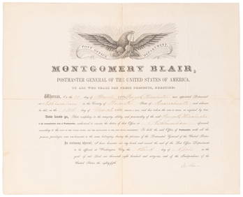
SOMERSET, Lord Charles (1767-1831) and BLAIR, Montgomery (1...Potter & Potter Auctions4.6(545)See Sold PriceMar 07, 2024
Southern Africa Cape of Good Hope-Madagascar ADMIRALTY sea chart 1935 (1955) mapJasper524.5(9.9k)See Sold PriceFeb 28, 2024
Gulf of Guinea. Ghana Togo Benin Nigeria. ADMIRALTY sea chart 1928 (1954) mapJasper524.5(9.9k)See Sold PriceFeb 28, 2024
South Namibia coast. Walvis Bay-Orange River ADMIRALTY sea chart 1881 (1954) mapJasper524.5(9.9k)See Sold PriceFeb 28, 2024
ANTIQUE ROMAN ARMORIAL VELLUM BINDING, 1744, ILLUSTRATED WITH AN ANTIQUE MAP BY FLORUSNY Elizabeth 4.2(86)See Sold PriceMar 03, 2024
1774: AN ANTIQUE ILLUSTRATED TWO-VOLUME HISTORY OF PERUVIAN DISCOVERY AND CONQUEST WITH MAPNY Elizabeth 4.2(86)See Sold PriceMar 03, 2024
ANTIQUE 1686 OPERA OMNIA BY JOHN LIGHTFOOT TELLIMA BOUND FOLIO WITH ISRAEL MAPNY Elizabeth 4.2(86)See Sold PriceMar 03, 2024
1792 OLD INDIA HISTORY ANTIQUE ILLUSTRATED WITH MAPS OF THE EIGHTEENTH CENTURY IN FRENCHNY Elizabeth 4.2(86)See Sold PriceMar 03, 2024
1675: ANTIQUE ILLUSTRATED JULIUS CAESAR MAPS OF ROMAN HISTORYNY Elizabeth 4.2(86)See Sold PriceMar 03, 2024
CURTIUS RUFUS QUINTUS, SIXTEENTH-CENTURY ELZEVIER HISTORIARUM LIBRI W/ MAP 16.33NY Elizabeth 4.2(86)See Sold PriceMar 03, 2024


![[MAP]. Manuscript map of North and South America (1 of 6)](https://p1.liveauctioneers.com/514/38480/16487066_1_x.jpg?height=282&quality=70&version=1363614971)

![JAPAN. Pocket map. [Ca. late 1800's - early 1900s] (1 of 8)](https://p1.liveauctioneers.com/179/54294/26374874_1_x.jpg?height=282&quality=70&version=1398371595)


![2 Maps incl: BOWLES’S NEW POCKET MAP... [ca. 1780] (1 of 8)](https://p1.liveauctioneers.com/179/72471/37352403_1_x.jpg?height=282&quality=70&version=1432244280)