SoldManuscript Map of West Roxbury Mass 1880MAP - HOPKINS, H. W. (surveyor). Manuscript "Map of West Roxbury ... From Official Records, Private Plans and Actual Surveys."Np [presumably West Roxbury]: c. 1880. Original manuscript map (18See Sold Price
SoldCivil War Manuscript Map, West TN RailroadsCivil War era ink on laid paper hand drawn map depicting West Tennessee and Northern Mississippi and Alabama. The strategical map focuses on towns, cities, and railroad stations and their positions alSee Sold Price
Jamaica Pond, West Roxbury Mass by H. BuffordHandcolored lithograph on paper, 11.75 x 16 inches, sight. Very good condition, nicely framed and matted.See Sold Price
SoldCurrier & Ives, color lithographCurrier & Ives, color lithograph, Currier & Ives (American, 19th c.), "Jamaica Pond, West Roxbury, Mass.", c. 1858, published by J.H. Bufford, gallery label verso, 20.5"h x 26"w (sight), 30.5" x 37.5"See Sold Price
SoldJohn Henry Bufford(American, 1810-1870) Jamaica Pond, West Roxbury, Mass., 1859, hand-colored lithograph, image 17 x 24 in.; gilt wood frame, 29-1/4 x 34-1/2 in.See Sold Price
Manuscript Map of the West Indies showing the Southern Coast of the Dominican Republic[West Indies, Dominican Republic] Plano dela Bahya de Ocoa Situado en la Banda del sux dela Isla Espanola... Manuscript Map in pen and ink. ca. 1780. 14 7/8" x 19 3/8" sheet. Manuscript Map of the SouSee Sold Price
Locoste: Antique Map of Mexico & West Indies, 1880Map: Mexique, Amerique Centrale Et Antilles. With View of Mexico City Publication Date: 1880 Authors: J. MIGEON, LACOSTE, CH. Publisher: J. MIGEON Size: Folio – 12.30 H x 17.00 W Inches Attractive mSee Sold Price
SoldAuthentic Vintage 1880 - Canada & West Indies MapAuthentic Vintage 1880 - Canada & West Indies Map **|**|** This is a beautiful, 135 year old map of Canada & West Indies - published in New York by the D. Appleton & Co. The details are crisp and theSee Sold Price
Authentic Vintage 1880 - Canada & West Indies MapAuthentic Vintage 1880 - Canada & West Indies Map **|**|** This is a beautiful, 135 year old map of Canada & West Indies - published in New York by the D. Appleton & Co. The details are crisp and theSee Sold Price
Sold[West Virginia, Oil Maps, c. 1850]A collection of three hand-colored manuscript maps of oil tracts in West Virginia, ink and watercolor on onion-skin linen, c.1850, including: *** "Oil Tract in Gilmer County, W. Va.," 248 x 319 mm, soSee Sold Price
SoldJ. T. Bentley etchingJ. T. Bentley (Amreican fl. 1880-1919)- ''Near Manomet, Mass'' (West Coast of Cape Cod Bay)- etching, 1887, signed in pencil, tape residue verso, otherwise very good condition. 11 x 18 3/4''See Sold Price
SoldRand Mcnally & Co.'s Railroad Map Of West TexasRailroad Map of West Texas Rand, McNally & Co. c. 1880, 21 x 14.25 in Please note that this lot has a confidential reserve. When you leave a bid in advance of the auction, submit your maximum. Jasper5See Sold Price
Manuscript: Cattle Trails of the Old WestManuscript Map of Cattle Trails 20. [CATTLE TRAILS]. Original manuscript map entitled “Cattle Trails of the Old West,” executed in sepia ink on laid paper tipped onto thick board N.p., &rsSee Sold Price
Jamaica. West Indies Caribbean. ADMIRALTY sea chart 1880 (1946) old mapTITLE/CONTENT OF MAP: 'West Indies - Jamaica' DATE PRINTED: Surveyed 1873-1880. Published 1880. New edition 1915. Corrections to 1946 IMAGE SIZE: Approx 69.0 x 102.5cm, 27.25 x 40.25 inches (Large); PSee Sold Price
Jamaica. West Indies Caribbean. ADMIRALTY sea chart 1880 (1946) old mapTITLE/CONTENT OF MAP: 'West Indies - Jamaica' DATE PRINTED: Surveyed 1873-1880. Published 1880. New edition 1915. Corrections to 1946 IMAGE SIZE: Approx 69.0 x 102.5cm, 27.25 x 40.25 inches (Large); PSee Sold Price
Sold1874 Map of Boston. GM Hopkins. This map includes1874 Map of Boston. GM Hopkins. This map includes portions of cities around Boston such as Cambridge, Charleston, Somerville, Chelsea, Brighton, Brookline, West Roxbury, Dorchester, and South Boston.See Sold Price
Atlas Geographique Manuscript Map AtlasDrawn and handpainted by Sophie de Baure. C 1840. French manuscript atlas with title page, table of contents and 20 beautiful hand drawn and colored maps. It is bound in contemporary burgundy full MorSee Sold Price
SoldManuscript map.- - German Fortification,covering a stretch of the Bas-Rhin department from Chateau de Lichtenberg to the west to Drusenheim in the east, including the towns of Hagenau, Bischwill and Pfaffenhoffen amonst others, finely drawnSee Sold Price
George Ripley - Transcendentalist: Brook Farm, West Roxbury, MA - Clipped AutographGeorge Ripley autograph clipped from a larger document. Approximately 1.25 x 1.5." Near fine condition. George Ripley (October 3, 1802 – July 4, 1880) was an American social reformer, UnitarianSee Sold Price
SoldFacsmilie of Thompson & West 1880 History of SacramentoHeading: (Sacramento County) Author: Title: History of Sacarmento County California with Illustrations Descriptive of its Scenery Place Published: Berkeley, California Publisher:Howell-North DatSee Sold Price
SoldFacsimile of Thompson & West 1880 History of SacramentoHeading: (Sacramento County) Author: Title: History of Sacarmento County California with Illustrations Descriptive of its Scenery Place Published: Berkeley, California Publisher:Howell-North DatSee Sold Price
SoldWestern Hemisphere Antique MapManuscript map, pen, ink, watercolor on paper of the Western Hemisphere. America west of Mississippi River called Louisiana. Cherokees indicated in southeast. Circa late 18th Century. 14 3/4" x 14".See Sold Price
Civil war ms. map of Shiloh regionHeading: (Civil War - manuscript map) Author: Title: Manuscript Civil War era map, likely of Confederate origin, depicting portions of West Tennessee, Northern Alabama, and Mississippi Place PublisheSee Sold Price
Civil war ms. map of Shiloh regionHeading: (Civil War - manuscript map) Author: Title: Manuscript Civil War era map, likely of Confederate origin, depicting portions of West Tennessee, Northern Alabama, and Mississippi Place PublisheSee Sold Price
Central Railroad of New Jersey Map of Sandy Hook Route-ca. 1903JM Hobby Supply and Railroad Artifact Auctions4.4(127)See Sold PriceFeb 24, 2024
Northern Pacific RR Washington and Northern Idaho Map Folder-1941JM Hobby Supply and Railroad Artifact Auctions4.4(127)See Sold PriceFeb 24, 2024
Rand McNally Township County and Railroad Map of Indiana-1880JM Hobby Supply and Railroad Artifact Auctions4.4(127)See Sold PriceFeb 24, 2024
Union Pacific RR Across The Continent West From Omaha, NE Book-April 2, 1868JM Hobby Supply and Railroad Artifact Auctions4.4(127)See Sold PriceFeb 24, 2024
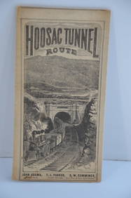
Fitchburg Railroad 1880 Hoosac Tunnel Route Public TimetableJM Hobby Supply and Railroad Artifact Auctions4.4(127)See Sold PriceFeb 24, 2024
Fort Wayne and Pennsylvania RR 1880 Public TimetableJM Hobby Supply and Railroad Artifact Auctions4.4(127)See Sold PriceFeb 24, 2024
Great Western RY November 1, 1880 Public TimetableJM Hobby Supply and Railroad Artifact Auctions4.4(127)See Sold PriceFeb 24, 2024
Portfolio of 15 County Maps by Robert Morden (English 1650-1703)Nadeau's Auction Gallery4.7(409)See Sold PriceFeb 24, 2024
Rand McNally Railroad Map Cabinet w/ 21 Railroad MapsRail & Road Auctions4.6(165)See Sold PriceMar 08, 2024
[ARCTIC]. BOWEN, Emanuel. A New & Accurate Map of the North...Potter & Potter Auctions4.6(545)See Sold PriceMar 07, 2024
Arrowsmith & Lewis - Map of the United StatesTrillium Antique Prints & Rare Books4.5(32)See Sold PriceFeb 24, 2024
Carey, pub. 1796 - Map of KentuckyTrillium Antique Prints & Rare Books4.5(32)See Sold PriceFeb 24, 2024
Carey, pub. 1796 - Map of the Tennassee State formerly part of North Carolina (Tennessee)Trillium Antique Prints & Rare Books4.5(32)See Sold PriceFeb 24, 2024
Lot of 12 Vintage 1953 & 1954 General Mills Promotional Tin License PlatesBodnar's Auction Sales4.6(615)See Sold PriceMar 28, 2024
Gulf of Guinea. Ghana Togo Benin Nigeria. ADMIRALTY sea chart 1928 (1954) mapJasper524.5(9.9k)See Sold PriceFeb 28, 2024
South Namibia coast. Walvis Bay-Orange River ADMIRALTY sea chart 1881 (1954) mapJasper524.5(9.9k)See Sold PriceFeb 28, 2024
"Map of the Parishes of Iberville Most of West Baton Rouge and Including Parts of the Parishes ofCrescent City Auction Gallery4.3(231)See Sold PriceMar 09, 2024
1880 WHAT MR. DARWIN SAW IN SHIP BEAGLE ANTIQUE DURING HIS WORLD TOURNY Elizabeth 4.2(86)See Sold PriceMar 03, 2024


![[West Virginia, Oil Maps, c. 1850] (1 of 5)](https://p1.liveauctioneers.com/3532/111460/57224277_1_x.jpg?height=282&quality=70&version=1509131847)


![[ARCTIC]. BOWEN, Emanuel. A New & Accurate Map of the North... (1 of 1)](https://p1.liveauctioneers.com/928/318880/171360917_1_x.jpg?height=282&quality=70&version=1707501302)