SoldManuscript Map of Maracaybo-1770Hand drawn map of the river and surrounding area a Venezuelan town and fortress on the W. shore of the outlet of Lake Maracaybo in Venezuela. Map drawn by Juan Xavier de Emasabel, river pilot, in 1770See Sold Price
[MAP]. ZÚÑIGA Y ONTIVEROS. Manuscript map. Mexico, 1770392. [MAP]. ZÚÑIGA Y ONTIVEROS, Felipe de. Manuscript map: “El presente Mapa Demuestra la cituacion, plano, y repartimiento, que en la actualidad tienen los Arroyos que bajan de SiSee Sold Price
French Manuscript Map of IndiaFrench Manuscript Map of Northeast India Watercolor and ink on paper. Ca.1765-1770. 42 x 66 inches Marks the End of French Colonial Aspirations in India, The Most Accurate Manuscript Map of India fromSee Sold Price
MAP - Strasbourg, France. AnonymousStrasbourg, France. Anonymous, Plan des Environs de la Citadelle de Strasbourg, 1770 (circa). Hand Color. This elegant manuscript map depicts Strasbourg in Alsace, on the border of Germany and France.See Sold Price
SoldStaffordshire.- Hill (R., surveyor)Staffordshire.- Hill (R., surveyor) A Survey and Map of Lands in the Parish of Ipstones... belonging to I. Sneyd... taken in the Years 1770 & 1783,pen and ink estate map on vellum, with manuscSee Sold Price
SoldManuscript map of northern Mideast/ SE Europe.[Manuscript Map]. Middle East and southeastern Europe, emphasizing the coastlines of the eastern Mediterranean, the Black Sea, and the northernmost portion of the Red Sea. Cartouche and all labels onSee Sold Price
SoldEarly Chinese Language Grand Format Manuscript MapEarly Chinese Language Grand Format Manuscript Map of China circa 1800 (date uncertain). Hand coloring on mulberry paper. Blank on verso. May be a copy of Ming period map. Measures 49x35''. Very goodSee Sold Price
SoldCivil War Manuscript Map, West TN RailroadsCivil War era ink on laid paper hand drawn map depicting West Tennessee and Northern Mississippi and Alabama. The strategical map focuses on towns, cities, and railroad stations and their positions alSee Sold Price
Sold[MAP]. Manuscript map of North and South America231. [MAP]. Anonymous manuscript map in Arabic (?) on heavy laid paper of North and South America, within gilt border, map proper with background painting in slate blue, outlines of countries in greenSee Sold Price
SoldManuscript Map of HimalayasEarly manuscript map of Himalayas showing mule and foot paths, circa 1900. On thin wove paper, 20.75" x 15.25". A rather unique item.See Sold Price
SoldCartographer's Original Manuscript MapCartographer's Original Manuscript Map Lake Pochartrain. (Found in a bound volume of Epsy's Weather Maps ca. 1840.)x Measures 10 7/8" x 8.5". Left corner torn away. Unframed, loose and not glued or moSee Sold Price
SoldMalaya & Singapore 1945 Manuscript Map by Dobby"Distribution of Population in Malaya 1945 - E. H. G. Dobby" Manuscript Map, Rare Printers Proof (Unique) by Dobby. Later Published in "The Geographical Journal" by the RGS. With margin pencil annotatSee Sold Price
SoldHand-colored manuscript map of China c.1780Title: Hand-colored manuscript map of China & Southeast Asia, with extensive text on the map in Chinese characters Author: ** Description: Hand-colored map on ricepaper, folding into covers. overall 8See Sold Price
SoldManuscript map of Delaware, late 18th cent, drawn byManuscript map of Delaware, late 18th cent, drawn by Rebecca McElwee, ink on parchment, measures 14-1/2" x 8-1/4" sight, framed size 20-3/4" x 14-1/2", excellent conditionSee Sold Price
SoldManuscript map of Canton, c.1930Title: Manuscript Map of Guangzhou (Canton) Author: Description: Hand-drawn map in black, blue, red and yellow on thin rice or "onion paper". 53x73 cm (20¾x28¾"). A verySee Sold Price
Sold19th C Linen Manuscript Map Tuckingmill Cornwall19th century manuscript linen map on an area referred to as Tuckingmill in the County of Cornwall. Very Good, Measures 9 x 7”. Please note that this lot has a confidential reserve. When you leave aSee Sold Price
SoldAmerican Civil War Era Manuscript MapAmerican Civil War Era Manuscript Map, "Copy of a Map Sheet No.1 Military Reconnaissance Dept. Va; Major Genl. Wool Comdg., drawn by Sergt. Ch. Worret...under the direction of Col: T.J. Cram, inscribeSee Sold Price
SoldKorea C1945 Rare Manuscript Map. Geographical JournalVintage Manuscript Map, Rare Printers Proof (Unique) Later Published in "The Geographical Journal" by the RGS. With margin pencil annotations by the Cartographer. On very thick paper. Paper Size: 16.5See Sold Price
Sold[AVIATION: AMELIA MARY EARHART]. Manuscript Map18. [AVIATION: AMELIA MARY EARHART]. SWARTZ, Fred Charles (1896-1969). “The route the U.S.S. Colorado took on the hunt for Amelia Earhart and her navigator Fred Noonan. Commenced July 6, 1837 enSee Sold Price
SoldSOUTHERN MANUSCRIPT MAPSOUTHERN MANUSCRIPT MAP, ink on paper with hand-colored outlining, depicting Spanish America prominently featuring Louisiana, signed "Harriet Hayles, Charles Town, South Carolina, 1785", with accompanSee Sold Price
SoldCanary Islands & Morocco C1945 Rare Manuscript Map. RGSManuscript Map, Rare Printers Proof (Unique) Later Published in "The Geographical Journal" by the RGS. With margin pencil annotations by the Cartographer. On very thick paper. Paper Size: 19 x 15 inchSee Sold Price
SoldSmithfold Colliery, Manchester C1870 Manuscript MapPrinted Map, with Manuscript additions. Smithfold Colliery near Bolton and Manchester, UK. Paper Size: 36 x 26 inch (91 x 66cm) Rolled. Linen backed. Some soiling. Some of the map pulling away from LiSee Sold Price
SoldNew Zealand C1945 Rare Manuscript Map. RGSShowing Otago, Canterbury, Christchurch, Godley River and the Tasman Sea. Manuscript Map, Rare Printers Proof (Unique) Later Published in "The Geographical Journal" by the RGS. With margin pencil annoSee Sold Price
Sold19th century French School. Manuscript map of Indi19th century French School. Manuscript map of India and Ceylon,with detailed place names and scales, pen and black ink on vellum, 205 x 225mm., central vertical and horizontal folds, slight fiSee Sold Price
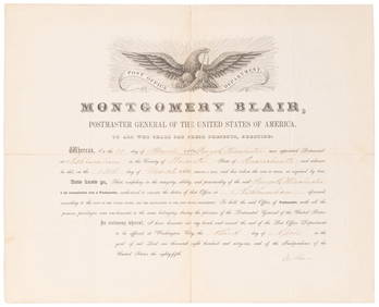
SOMERSET, Lord Charles (1767-1831) and BLAIR, Montgomery (1...Potter & Potter Auctions4.6(539)See Sold PriceMar 07, 2024
[ENSLAVEMENT & ABOLITION]. Manuscript legal document involving the estate of Solomon Boggan, whoFreeman's | Hindman4.4(1.6k)See Sold PriceFeb 27, 2024
1558 SCANDINAVIA SWEDEN ILLUSTRATED HISTORY Gothorum Sveonumque historia antiqueJasper524.5(9.8k)See Sold PriceFeb 27, 2024
Bible, English.- Bible (The): that is, the Holy Scriptures contained in the Olde and Newe Testament,Forum Auctions4.3(52)See Sold PriceFeb 29, 2024
Southern Africa Cape of Good Hope-Madagascar ADMIRALTY sea chart 1935 (1955) mapJasper524.5(9.8k)See Sold PriceFeb 28, 2024
Gulf of Guinea. Ghana Togo Benin Nigeria. ADMIRALTY sea chart 1928 (1954) mapJasper524.5(9.8k)See Sold PriceFeb 28, 2024
South Namibia coast. Walvis Bay-Orange River ADMIRALTY sea chart 1881 (1954) mapJasper524.5(9.8k)See Sold PriceFeb 28, 2024
ANTIQUE ROMAN ARMORIAL VELLUM BINDING, 1744, ILLUSTRATED WITH AN ANTIQUE MAP BY FLORUSNY Elizabeth 4.3(84)See Sold PriceMar 03, 2024
1770 CASES HEARD, ARGUED, AND ADJUDGED IN THE HISTORIC WESTMINSTER COURT OF KING'S BENCHNY Elizabeth 4.3(84)See Sold PriceMar 03, 2024
1774: AN ANTIQUE ILLUSTRATED TWO-VOLUME HISTORY OF PERUVIAN DISCOVERY AND CONQUEST WITH MAPNY Elizabeth 4.3(84)See Sold PriceMar 03, 2024
ANTIQUE 1686 OPERA OMNIA BY JOHN LIGHTFOOT TELLIMA BOUND FOLIO WITH ISRAEL MAPNY Elizabeth 4.3(84)See Sold PriceMar 03, 2024
1792 OLD INDIA HISTORY ANTIQUE ILLUSTRATED WITH MAPS OF THE EIGHTEENTH CENTURY IN FRENCHNY Elizabeth 4.3(84)See Sold PriceMar 03, 2024
1675: ANTIQUE ILLUSTRATED JULIUS CAESAR MAPS OF ROMAN HISTORYNY Elizabeth 4.3(84)See Sold PriceMar 03, 2024
CURTIUS RUFUS QUINTUS, SIXTEENTH-CENTURY ELZEVIER HISTORIARUM LIBRI W/ MAP 16.33NY Elizabeth 4.3(84)See Sold PriceMar 03, 2024
1829 GERMAN-LANGUAGE ANTIQUE AMERICAN BIBLE ILLUSTRATED WITH MAPS OF PHILADELPHIANY Elizabeth 4.3(84)See Sold PriceMar 03, 2024
DAVOUT LOUIS NICOLAS: (1770-1823)International Autograph Auctions Europe S.L.4.5(52)See Sold PriceMar 14, 2024


![[MAP]. ZÚÑIGA Y ONTIVEROS. Manuscript map. Mexico, 1770 (1 of 5)](https://p1.liveauctioneers.com/514/38482/16500484_1_x.jpg?height=282&quality=70&version=1363615005)


![[MAP]. Manuscript map of North and South America (1 of 6)](https://p1.liveauctioneers.com/514/38480/16487066_1_x.jpg?height=282&quality=70&version=1363614971)


![[AVIATION: AMELIA MARY EARHART]. Manuscript Map (1 of 5)](https://p1.liveauctioneers.com/514/38480/16486640_1_x.jpg?height=282&quality=70&version=1363614971)


![[ENSLAVEMENT & ABOLITION]. Manuscript legal document involving the estate of Solomon Boggan, who (1 of 2)](https://p1.liveauctioneers.com/197/319238/171468041_1_x.jpg?height=282&quality=70&version=1707520367)


