ATLAS of ANTIENT GEOGRAPHY by SAMUEL BUTLER 1843John McInnis Auctioneers,LLC4.6(502)See Sold PriceFeb 24, 2024
18TH C. ANTIQUE MAP: FRENCH & INDIAN WAR, FRAMEDThomaston Place Auction Galleries4.4(386)See Sold PriceFeb 24, 2024
Rand McNally Railroad Map Cabinet w/ 21 Railroad MapsRail & Road Auctions4.6(165)See Sold PriceMar 08, 2024
Keith Haring - Ink on New York Map, Best Buddies, Inscribed, Signed, and DatedSapphire Auction Gallery4(67)See Sold PriceMar 02, 2024
LATE 17TH C. FRENCH MAP OF THE NEW WORLD BY ALEXIS-HUBERT JAILLOT (1632-1712)Thomaston Place Auction Galleries4.4(386)See Sold PriceFeb 24, 2024
Central Railroad of New Jersey Map of Sandy Hook Route-ca. 1903JM Hobby Supply and Railroad Artifact Auctions4.4(126)See Sold PriceFeb 24, 2024
Lot of Six Mixed Atlas Box Cars-HO Scale-New in BoxJM Hobby Supply and Railroad Artifact Auctions4.4(126)See Sold PriceFeb 25, 2024
Rand McNally/Santa Fe Railroad Map of Iowa-1912JM Hobby Supply and Railroad Artifact Auctions4.4(126)See Sold PriceFeb 24, 2024
NICOLAES VISSCHER (NETHERLANDS, 1618-1709) MAP OF THE NEW WORLDThomaston Place Auction Galleries4.4(386)See Sold PriceFeb 24, 2024
17TH C. WORLD MAP BY NICOLAES VISSCHER (NETHERLANDS, 1618-1709)Thomaston Place Auction Galleries4.4(386)See Sold PriceFeb 24, 2024
Lot of Six Mixed Atlas Cabooses-HO Scale-New in BoxJM Hobby Supply and Railroad Artifact Auctions4.4(126)See Sold PriceFeb 25, 2024
Malte-Brun: Antique Map of the Netherlands, 1829Title/Content of Map: 1829 Malte-Brun Map of the Netherlands -- Royaume des Pays-Bas en 1829 Date Printed: 1829, Paris Cartographer: M Malte-Brun Size: 11.7 x 8.8 in. A handsome map of the NetherlandsSee Sold Price
1834 Malte-Brun Antique Map of the NetherlandsTitle/Content of Map: 1834 Malte-Brun Map of the Netherlands -- The Seven United Provinces with their Dependencies Date Printed: 1834, Boston Cartographer: M. Malte-Brun / S. Walker Size: 9.3 x 7.5 inSee Sold Price
SoldMalte-Brun: Antique Map of Europe in 1829Title/Content of Map: 1829 Malte-Brun Map of Europe in 1829 -- Europe en 1829 Date Printed: 1829, Paris Cartographer: M Malte-Brun Size: 8.7 X 11.7 in. An attractive map of Europe showing its politicaSee Sold Price
1829 Malte-Brun Map of the Netherlands -- Royaume desTitle/Content of Map: 1829 Malte-Brun Map of the Netherlands -- Royaume des Pays-Bas en 1829 Date: 1829, Paris Cartographer: M Malte-Brun Size: 11.7 x 8.8 in. A handsome map of the Netherlands and LuxSee Sold Price
SoldMalte-Brun: Antique Map of the World per Herodotus 1812Title/Content of Map: 1812 Malte-Brun Map of the Known World per Herodotus -- Geographie d'Herodote Date Printed: 1812, Paris Cartographer: M Malte-Brun Size: 8.7 X 11.7 in. An excellent and very inteSee Sold Price
SoldMalte-Brun: Antique Map of Northern Africa, 1812Map: 1812 Malte-Brun Map of Northern Africa -- Afrique Ancienne Cartographer: M Malte-Brun Year / Place: 1812, Paris Map Dimensions: 8.7 X 12.7 in. Condition: Very Good - Excellent. Color outlined onSee Sold Price
SoldMalte-Brun: Antique Map of Austria, 1834Title/Content of Map: 1834 Malte-Brun Map of Austria -- Austria Date Printed: 1834, Boston Cartographer: M. Malte-Brun / S. Walker Size: 9.3 x 7.5 in. An attractive and highly detailed map with topogrSee Sold Price
SoldMalte-Brun: Antique Map of Southern Russia, 1810Map: Southern Russia Caucuses Region plus Crimea Date Printed: Circa 1810 Cartographer: Malte-Brun Material/Medium: Paper Size: Approx 9" x 14" Condition: Excellent Brun - from 'Precis de la geographiSee Sold Price
SoldMalte-Brun: Antique Map of Portugal & Spain, 1812Title/Content of Map: Portugal with parts of Western Spain Date Printed: 1812 Cartographer: Malte-Brun Material/Medium: Paper Size: 10" x 13 1/2" Published in Paris Conrad Malte-Brun (1775 - 1826), boSee Sold Price
Malte-Brun: Antique Map of Solar System MovementsTitle/Content of Map: 1834 Malte-Brun Terrestial Projections and Solar System Movements Date Printed: 1834, Boston Cartographer: M. Malte-Brun / S. Walker Size: 6.9 x 9.8 in. and 6.9 x 15.8 in. An intSee Sold Price
Malte-Brun: Antique Map of Turkey and Middle East, 1834Title/Content of Map: 1834 Malte-Brun Map of Turkey and Middle East -- Turkey in Asia Date Printed: 1834, Boston Cartographer: M. Malte-Brun / S. Walker Size: 9.3 x 7.5 in. An attractive and highly deSee Sold Price
Malte-Brun: Antique Map of Scotland, 1834Title/Content of Map: 1834 Malte-Brun Map of Scotland -- Scotland Date Printed: 1834, Boston Cartographer: M. Malte-Brun / S. Walker Size: 9.3 x 7.5 in. An attractive and highly detailed map with topoSee Sold Price
SoldMalte-Brun: Antique Map of Italy, 1834Title/Content of Map: 1834 Malte-Brun Map of Italy -- Italy Date Printed: 1834, Boston Cartographer: M. Malte-Brun / S. Walker Size: 9.3 x 7.5 in. An attractive and highly detailed map with topographiSee Sold Price
Malte-Brun: Antique Map of Scandinavia, 1812Title/Content of Map: 1812 Malte-Brun Map of Scandinavia -- Danemark Suede et Norwege Date Printed: 1812, Paris Cartographer: M Malte-Brun Size: 11.7 x 8.8 in. A handsome map of Scandinavia. Finland iSee Sold Price
Malte-Brun: Antique Map of Germany, 1812Title/Content of Map: 1812 Malte-Brun Map of Germany -- Confederat du Rhin Date Printed: 1812, Paris Cartographer: M Malte-Brun Size: 11.7 x 8.8 in. An attractive map of German states, showing its polSee Sold Price
Malte-Brun: Antique Map of Asia, 1834Title/Content of Map: 1834 Malte-Brun Map of Asia -- Asia Date Printed: 1834, Boston Cartographer: M. Malte-Brun / S. Walker Size: 9.3 x 7.5 in. An attractive and highly detailed map with topographicaSee Sold Price
SoldMalte-Brun: Antique Map of Central Oceanica, 1830Title/Content of Map: Central Oceanica Date Printed: 1830 Cartographer: MALTE-BRUN, CONRAD/J. H. YOUNG, sc. Size (inches): 7.5x7.5 From Malte-Brun's "A new General atlas, exhibiting the five great divSee Sold Price
Malte-Brun: Antique Map of Europe in 1500s & 1789Title: 1812 Malte-Brun Map Double Map of Europe in 1500s and 1789 -- Europe sons Charles-Quint [together with] Europe en 1789 Cartographer: M Malte-Brun Year / Place: 1812, Paris Map Dimensions: 8.7 XSee Sold Price
SoldMalte-Brun: Antique Map of Sicily, 1834Map: 1834 Malte-Brun Map of Sicily -- Sicily Cartographer: M. Malte-Brun / S. Walker Year / Place: 1834, Boston Dimensions: 9.3 x 7.5 in. Condition: Very Good. Nice strike, slight toning and foxing AnSee Sold Price
SoldMalte-Brun: Antique Map of England & Wales, 1834Map: 1834 Malte-Brun Map of England and Wales -- England and Wales Cartographer: M. Malte-Brun / S. Walker Year / Place: 1834, Boston Map Dimensions: 9.3 x 7.5 in. Condition: Very Good. Nice strike, sSee Sold Price
Malte-Brun: Antique Map of Scandinavia, 1812Map: 1812 Malte-Brun Map of Scandinavia -- Danemark Suede et Norwege Date Printed: 1812, Paris Cartographer: M Malte-Brun Size: 11.7 x 8.8 in. Condition: Very Good - Excellent. Color outlined on thickSee Sold Price
Malte-Brun: Antique Map of Ancient Civilized World 1812Title/Content of Map: 1812 Malte-Brun Map of Ancient Civilized World -- Monde Connu des Anciens Date Printed: 1812, Paris Cartographer: M Malte-Brun Size: 8.7 X 11.7 in. An excellent map showing the gSee Sold Price
Malte-Brun: Antique Map of France & Northern Italy 1812Title/Content of Map: 1812 Malte-Brun Map of France and Northern Italy -- Empire Francais et Royaume d'Italie Date Printed: 1812, Paris Cartographer: M Malte-Brun Size: 8.7 X 11.7 in. An attractive maSee Sold Price
Malte-Brun: Antique Map of Asia, 1834Map: 1834 Malte-Brun Map of Asia -- Asia Cartographer: M. Malte-Brun / S. Walker Year / Place: 1834, Boston Dimensions: 9.3 x 7.5 in. Condition: Very Good. Nice strike, slight toning and foxing. UncolSee Sold Price
MAP - Dufour, A. H. ( Malte / Brun ) :MAP - ESPAGNE PARTIE SUD DIVISEE EN PROVINCES ANCIENNES ( MAPLuis Porretta Fine Arts4.3(10)See Sold PriceMar 02, 2024
1834 Malte-Brun Map of the Caribbean -- West India IslandsJasper524.5(9.8k)See Sold PriceFeb 27, 2024
Carte de la Barbarie… l'empire de Maroc… North Africa Morocco. LAPIE 1829 mapJasper524.5(9.8k)See Sold PriceFeb 28, 2024
Carte d'Afrique. Africa Soudan Zanzibar. LAPIE 1831 old antique map plan chartJasper524.5(9.8k)See Sold PriceFeb 28, 2024
Carte de l'Afrique propre, de la Numidie… North Africa. LAPIE 1829 old mapJasper524.5(9.8k)See Sold PriceFeb 28, 2024
Afrique Ancienne. Ancient North Africa. MALTE-BRUN c1871 old antique map chartJasper524.5(9.8k)See Sold PriceFeb 28, 2024
Hubert Kornelisz (1689 - 1733) - Set of 2 Allegorical Copperplate Engravings, NetherlandsProverde Auctions4.3(3)See Sold PriceFeb 28, 2024
Hubert Kornelisz (1689 - 1733) - Set of 2 Allegorical Copperplate Engravings, NetherlandsProverde Auctions4.3(3)See Sold PriceFeb 28, 2024
Jan Goeree (1670-1731) - Set of 2 Italian Engravings of Roman ScenesProverde Auctions4.3(3)See Sold PriceFeb 28, 2024
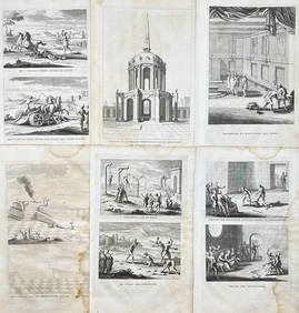
Antoine Augustin Calmet (1672-1757) - Set of 6 Jewish Engravings - Tomb monument of the kings ofProverde Auctions4.3(3)See Sold PriceFeb 28, 2024
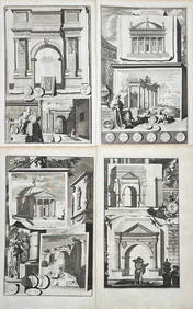
Jan Goeree (1670-1731) - Set av 4 Architecture Engravings - Church of Saint Pudentiana - AProverde Auctions4.3(3)See Sold PriceFeb 28, 2024
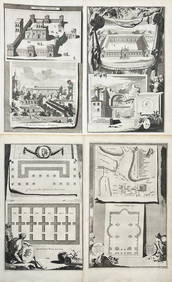
Jan Goeree (1670-1731) - Set av 4 Architecture Engravings - A Reconstruction of the Arch of DomitianProverde Auctions4.3(3)See Sold PriceFeb 28, 2024
Antoine Augustin Calmet (1672-1757) - Set of 6 Architecture Engraving - Temple of Jerusalem -Proverde Auctions4.3(3)See Sold PriceFeb 28, 2024
Set of 4 Maps - Netherlands - Seven United Provinces - Germany - Sweden, Denmark, Norway, FinlandProverde Auctions4.3(3)See Sold PriceFeb 28, 2024
Set of 3 Maps - Netherlands - Belgien - Switzerland - J. BarlowProverde Auctions4.3(3)See Sold PriceFeb 28, 2024