ATLAS of ANTIENT GEOGRAPHY by SAMUEL BUTLER 1843John McInnis Auctioneers,LLC4.6(504)See Sold PriceFeb 24, 2024
18TH C. ANTIQUE MAP: FRENCH & INDIAN WAR, FRAMEDThomaston Place Auction Galleries4.4(389)See Sold PriceFeb 24, 2024
Rand McNally Railroad Map Cabinet w/ 21 Railroad MapsRail & Road Auctions4.6(165)See Sold PriceMar 08, 2024
Keith Haring - Ink on New York Map, Best Buddies, Inscribed, Signed, and DatedSapphire Auction Gallery4.1(67)See Sold PriceMar 02, 2024
LATE 17TH C. FRENCH MAP OF THE NEW WORLD BY ALEXIS-HUBERT JAILLOT (1632-1712)Thomaston Place Auction Galleries4.4(389)See Sold PriceFeb 24, 2024
Central Railroad of New Jersey Map of Sandy Hook Route-ca. 1903JM Hobby Supply and Railroad Artifact Auctions4.4(126)See Sold PriceFeb 24, 2024
Lot of Six Mixed Atlas Box Cars-HO Scale-New in BoxJM Hobby Supply and Railroad Artifact Auctions4.4(126)See Sold PriceFeb 25, 2024
Rand McNally/Santa Fe Railroad Map of Iowa-1912JM Hobby Supply and Railroad Artifact Auctions4.4(126)See Sold PriceFeb 24, 2024
NICOLAES VISSCHER (NETHERLANDS, 1618-1709) MAP OF THE NEW WORLDThomaston Place Auction Galleries4.4(389)See Sold PriceFeb 24, 2024
17TH C. WORLD MAP BY NICOLAES VISSCHER (NETHERLANDS, 1618-1709)Thomaston Place Auction Galleries4.4(389)See Sold PriceFeb 24, 2024
Lot of Six Mixed Atlas Cabooses-HO Scale-New in BoxJM Hobby Supply and Railroad Artifact Auctions4.4(126)See Sold PriceFeb 25, 2024
Malte-Brun: Antique Map of Scandinavia, 1812Title/Content of Map: 1812 Malte-Brun Map of Scandinavia -- Danemark Suede et Norwege Date Printed: 1812, Paris Cartographer: M Malte-Brun Size: 11.7 x 8.8 in. A handsome map of Scandinavia. Finland iSee Sold Price
Malte-Brun: Antique Map of Scandinavia, 1812Map: 1812 Malte-Brun Map of Scandinavia -- Danemark Suede et Norwege Date Printed: 1812, Paris Cartographer: M Malte-Brun Size: 11.7 x 8.8 in. Condition: Very Good - Excellent. Color outlined on thickSee Sold Price
Malte-Brun: Antique Map of Germany, 1812Title/Content of Map: 1812 Malte-Brun Map of Germany -- Confederat du Rhin Date Printed: 1812, Paris Cartographer: M Malte-Brun Size: 11.7 x 8.8 in. An attractive map of German states, showing its polSee Sold Price
Malte-Brun: Antique Map of Germany, 1812Map: 1812 Malte-Brun Map of Germany -- Confederat du Rhin Date Printed: 1812, Paris Cartographer: M Malte-Brun Size: 11.7 x 8.8 in. Condition: Very Good - Excellent. Color outlined on thick paper stocSee Sold Price
SoldMalte-Brun: Antique Map of Northern Africa, 1812Map: 1812 Malte-Brun Map of Northern Africa -- Afrique Ancienne Cartographer: M Malte-Brun Year / Place: 1812, Paris Map Dimensions: 8.7 X 12.7 in. Condition: Very Good - Excellent. Color outlined onSee Sold Price
SoldMalte-Brun: Antique Map of Portugal & Spain, 1812Title/Content of Map: Portugal with parts of Western Spain Date Printed: 1812 Cartographer: Malte-Brun Material/Medium: Paper Size: 10" x 13 1/2" Published in Paris Conrad Malte-Brun (1775 - 1826), boSee Sold Price
Malte-Brun: Antique Map of Southern France, 1812Title/Content of Map: 1812 Malte-Brun Map of Southern France -- Partie Occidentale de l'Empire Francais Date Printed: 1812, Paris Cartographer: M Malte-Brun Size: 11.7 x 8.8 in. An attractive map of sSee Sold Price
Malte-Brun: Antique Map of European Russia, 1812Map: 1812 Malte-Brun Map of European Russia -- Russie d'Europe Date Printed: 1812, Paris Cartographer: M Malte-Brun Size: 11.7 x 8.8 in. Condition: Very Good - Excellent. Color outlined on thick paperSee Sold Price
Malte-Brun: Antique Map of Ancient Civilized World 1812Title/Content of Map: 1812 Malte-Brun Map of Ancient Civilized World -- Monde Connu des Anciens Date Printed: 1812, Paris Cartographer: M Malte-Brun Size: 8.7 X 11.7 in. An excellent map showing the gSee Sold Price
Malte-Brun: Antique Map of France & Northern Italy 1812Title/Content of Map: 1812 Malte-Brun Map of France and Northern Italy -- Empire Francais et Royaume d'Italie Date Printed: 1812, Paris Cartographer: M Malte-Brun Size: 8.7 X 11.7 in. An attractive maSee Sold Price
Malte-Brun: Antique Map of France & Northern Italy 1812Title/Content of Map: 1812 Malte-Brun Map of France and Northern Italy -- France et Italie Sept.Ale 1789 Date Printed: 1812, Paris Cartographer: M Malte-Brun Size: 8.7 X 11.7 in. An attractive map ofSee Sold Price
SoldMalte-Brun: Antique Map of the World per Herodotus 1812Title/Content of Map: 1812 Malte-Brun Map of the Known World per Herodotus -- Geographie d'Herodote Date Printed: 1812, Paris Cartographer: M Malte-Brun Size: 8.7 X 11.7 in. An excellent and very inteSee Sold Price
1812 Malte-Brun Map of Scandinavia -- Danemark Suede etReserve Reduced! Title/Content of Map: 1812 Malte-Brun Map of Scandinavia -- Danemark Suede et Norwege Date: 1812, Paris Cartographer: M Malte-Brun Size: 11.7 x 8.8 in. A handsome map of Scandinavia.See Sold Price
1812 Malte-Brun Map of Scandinavia -- Danemark Suede etTitle/Content of Map: 1812 Malte-Brun Map of Scandinavia -- Danemark Suede et Norwege Date: 1812, Paris Cartographer: M Malte-Brun Size: 11.7 x 8.8 in. A handsome map of Scandinavia. Finland is pert oSee Sold Price
1812 Malte-Brun Map of Scandinavia -- Danemark Suede etTitle/Content of Map: 1812 Malte-Brun Map of Scandinavia -- Danemark Suede et Norwege Date: 1812, Paris Cartographer: M Malte-Brun Size: 11.7 x 8.8 in. A handsome map of Scandinavia. Finland is pert oSee Sold Price
1812 Malte-Brun Map of Scandinavia -- Danemark Suede etTitle/Content of Map: 1812 Malte-Brun Map of Scandinavia -- Danemark Suede et Norwege Date: 1812, Paris Cartographer: M Malte-Brun Size: 11.7 x 8.8 in. A handsome map of Scandinavia. Finland is pert oSee Sold Price
Sold1812 Malte-Brun Map of Scandinavia -- Danemark Suede etTitle/Content of Map: 1812 Malte-Brun Map of Scandinavia -- Danemark Suede et Norwege Cartographer: M Malte-Brun Year/Place: 1812, Paris Size: 11.7 x 8.8 in. A handsome map of Scandinavia. Finland isSee Sold Price
Malte-Brun: Antique Map of Europe in 1500s & 1789Title: 1812 Malte-Brun Map Double Map of Europe in 1500s and 1789 -- Europe sons Charles-Quint [together with] Europe en 1789 Cartographer: M Malte-Brun Year / Place: 1812, Paris Map Dimensions: 8.7 XSee Sold Price
SoldMalte-Brun: Antique Double Map of Europe in 1500 & 1789Title/Content of Map: 1812 Malte-Brun Map Double Map of Europe in 1500s and 1789 -- Europe sons Charles-Quint [together with] Europe en 1789 Date Printed: 1812, Paris Cartographer: M Malte-Brun Size:See Sold Price
Malte-Brun: Antique Map of the World during CharlemagneTitle/Content of Map: 1812 Malte-Brun Map of the Known World during Charlemagne's period -- Geographie du Moyen Age… Date Printed: 1812, Paris Cartographer: M Malte-Brun Size: 8.7 X 11.7 in. ConditiSee Sold Price
Malte-Brun: Antique Double Map of Europe in 1500 & 1789Map: 1812 Malte-Brun Map Double Map of Europe in 1500s and 1789 -- Europe sons Charles-Quint [together with] Europe en 1789 Date Printed: 1812, Paris Cartographer: M Malte-Brun Size: 8.7 X 11.7 in. CoSee Sold Price
Carte de L'Europe. Map of Europe. MALTE-BRUN c1871 old antique plan chartTITLE/CONTENT OF MAP: 'Scandinavia, or Sweden, Denmark and Norway' DATE PRINTED: 1830 IMAGE SIZE: Approx 60.5 x 51.0cm, 23.75 x 20 inches (Large); Please note that this is a folding map. TYPE: AntiqueSee Sold Price
MAP - Dufour, A. H. ( Malte / Brun ) :MAP - ESPAGNE PARTIE SUD DIVISEE EN PROVINCES ANCIENNES ( MAPLuis Porretta Fine Arts4.3(10)See Sold PriceMar 02, 2024
Arrowsmith & Lewis - Map of PolynesiaTrillium Antique Prints & Rare Books4.5(30)See Sold PriceFeb 24, 2024
Arrowsmith & Lewis - Map of North AmericaTrillium Antique Prints & Rare Books4.5(30)See Sold PriceFeb 24, 2024
Arrowsmith & Lewis - Map of the World on Mercator's ProjectionTrillium Antique Prints & Rare Books4.5(30)See Sold PriceFeb 24, 2024
Arrowsmith & Lewis - Map of LouisianaTrillium Antique Prints & Rare Books4.5(30)See Sold PriceFeb 24, 2024
Arrowsmith & Lewis - Map of the United StatesTrillium Antique Prints & Rare Books4.5(30)See Sold PriceFeb 24, 2024
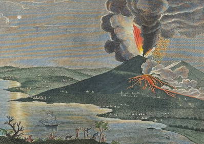
Filomarino - Mount Vesuvius Volcano Erupting. 6Trillium Antique Prints & Rare Books4.5(30)See Sold PriceFeb 24, 2024
Filomarino - Mount Vesuvius Volcano Erupting. 7Trillium Antique Prints & Rare Books4.5(30)See Sold PriceFeb 24, 2024
1558 SCANDINAVIA SWEDEN ILLUSTRATED HISTORY Gothorum Sveonumque historia antiqueJasper524.5(9.8k)See Sold PriceFeb 27, 2024
1834 Malte-Brun Map of the Caribbean -- West India IslandsJasper524.5(9.8k)See Sold PriceFeb 27, 2024
West Africa by Arrowsmith & Lewis 1812 old antique vintage map plan chartJasper524.5(9.8k)See Sold PriceFeb 28, 2024
Afrique Ancienne. Ancient North Africa. MALTE-BRUN c1871 old antique map chartJasper524.5(9.8k)See Sold PriceFeb 28, 2024
Africa by Arrowsmith & Lewis 1812 old antique vintage map plan chartJasper524.5(9.8k)See Sold PriceFeb 28, 2024
Guthrie, William 1812 Antique Map. Spain and PortugalAlbion Auctions4.6(341)See Sold PriceMar 01, 2024
Per Olof Christopher Aurivillius (1843-1928) - Set of 3 Prints - Butterflies - ScandinaviaProverde Auctions4.3(3)See Sold PriceFeb 28, 2024