SoldLewis Evans and Thomas Jefferys, A general Map of theEVANS, Lewis (ca 1700-1756) - JEFFERYS, Thomas (1719-1771). A general Map of the Middle British Colonies in America: via Virginia, Maryland, Delaware, Pensilvania, New Jersey, New York, Connecticut anSee Sold Price
SoldEVANS, LEWIS; and JEFFERYS, THOMAS. A GeneralEVANS, LEWIS; and JEFFERYS, THOMAS. A General Map of the Middle British Colonies in America. Double-page engraved map, 510x680 mm, wide margins; hand-colored in outline; some scattered browning and ofSee Sold Price
SoldEvans, Lewis (ca. 1900-1756). 'A General Map of TheEvans, Lewis (ca. 1900-1756). 'A General Map of The Middle British Colonies...', Printed in London, 1771, Engraved and hand colored, Thomas Jeffery's edition. Framed dimensions: h: 27 x w: 20 7/8 in.See Sold Price
SoldLewis Evans and Thomas Jeffreys hand colored outlinedLewis Evans and Thomas Jeffreys hand colored outlined double page engraved map A General Map of the Middle British Colonies in America marked lower left: Sold by R. Sayer in Fleet Street and T. JefSee Sold Price
SoldPownall & Evans Map of Middle British ColoniesPownall, Thomas (1722-1805). After Lewis Evans (c. 1700-1756). A General Map of the Middle British Colonies... Engraved map with original color in outline. London: Sayer & Bennett, 1776. 20 1/2" x 27"See Sold Price
1794 A New and General Map of the Middle DominionsThis is a fine old color example of the Laurie & Whittle edition of Lewis Evans' landmark map published from the Surveys of Evans, Thomas Walker and Christopher Gist, 1750-51. Evans’ map isSee Sold Price
1794 A New and General Map of the Middle DominionsThis is a fine old color example of the Laurie & Whittle edition of Lewis Evans' landmark map published from the Surveys of Evans, Thomas Walker and Christopher Gist, 1750-51. Evans’ map isSee Sold Price
SoldEvans, Lewis A General Map of the Middle British Colonies in AmericaEvans, Lewis A General Map of the Middle British Colonies in America viz. Virginia, Maryland, Delaware, Pensilvania, New-Jersey, New York, Connecticut and Rhode Island: of Aquanishuonigy the Country oSee Sold Price
SoldLewis Evans, A New and General Map of the MiddleEVANS, Lewis (ca 1700-1756). A New and General Map of the Middle Dominions belonging to the United States of America. London: Laurie & Whittle, 1793. Single sheet, matted and framed (ca 20 x 26 4/8 inSee Sold Price
SoldEVANS, LEWIS. A General Map of the Middle BritEVANS, LEWIS. A General Map of the Middle British Colonies. Engraved folding map, 495x670 mm, ample margins; hand-colored in outline; fire browning in upper and side margins, extending a short distancSee Sold Price
SoldEVANS, LEWIS. A General Map of the Middle BritEVANS, LEWIS. A General Map of the Middle British Colonies in America. Double-page engraved map, 500x645 mm, trimmed to or just within the neatline on the right side, other margins ample; hand-coloredSee Sold Price
SoldEVANS, LEWIS. A General Map of the Middle BritEVANS, LEWIS. A General Map of the Middle British Colonies in America. Double-page engraved map, 490x675 mm, wide margins; hand-colored in outline; considerably foxed, few nicks and short tears at edgSee Sold Price
SoldEvans - Map of the Middle British ColoniesLewis Evans (circa 1700-1756), A General Map of The Middle British Colonies, in America; Viz Virginia, Màriland, Dèlaware, Pensilvania, New-Jersey, New-York, Connecticut, And Rhode Island, 1755, JaSee Sold Price
SoldEvans - Map of the Middle British ColoniesLewis Evans (circa 1700-1756), A General Map of The Middle British Colonies in America Viz. Virginia, Maryland, Delaware, Pensilvania, New-Jersey, New York, Connecticut & Rhode-Island of AquanshuonigySee Sold Price
SoldEvans Map of the Middle British Colonies, 1755EVANS, Lewis (1700-1756). A General Map of the Middle British Colonies, in America; viz Virginia, Mariland, Delaware Pensilvania, New-Jersey New-York, Connecticut, and Rhode Island of Aquanishuonigy,See Sold Price
SoldBowles Map of the British ColoniesBOWLES, Carrington (1724-1793 ), After EVANS, Lewis (1700-1756). A General Map of the Middle British Colonies in America... Engraved Map with original hand color in part. London, 1771 (3rd State). 21See Sold Price
Sold(Maps and Charts, North America), Evans, Lewis (17(Maps and Charts, North America), Evans, Lewis (1700?-1756), A General Map of the Middle British Colonies in America: viz Virginia, Maryland, Delaware, Pensilvania, New Jersey, New York, Connecticut aSee Sold Price
Sold1794 A New and General Map of the Middle DominionsBy: Lewis Evans published by Laurie & Whittle Date: 1794 (Published) London Dimensions: 18.75 x 25.6 inches (47.6 x 65.02 cm) This is a fine old color example of the Laurie & Whittle edition of LewisSee Sold Price
SoldThe General Map of the Middle British Colonies...The General Map of the Middle British Colonies, In America...Lewis Evans (1700-c.1756) & John Gibson (1750-1792). London:Jeffreys, 1758. Engraved map with original hand color in outline. 20 x 27 incheSee Sold Price
SoldLewis Evans published by Robert Sayer and John BenA General Map of the Middle British Colonies in America Copperplate engraving, London, 1776 Reference: Page 165, Plate 98 in Schwartzês The Mapping of AmericaSee Sold Price
Lewis Evans, Geographical, Historical, Political,EVANS, Lewis (ca 1700-1756). Geographical, Historical, Political, Philosophical and Mechanical Essays. The First, Containing an Analysis of a General Map of the Middle British Colonies in America; AndSee Sold Price
SoldUpdated Edition of Lewis Evan's Engraved Map of theA General Map. of the Middle British Colonies... and since corrected and improved . . . By T. Pownall. Lewis Evans (c. 1700-1756). Engraved map with original color in outline. London: R. Sayer & J. BeSee Sold Price
SoldJohn Lodge North America Map, 1778North America, John Lodge, London 1778- ''A General Map of North America: from the Latest Observation''- Imprint recognizes that this second print uses Thomas Jeffery's 1776 plate with revisions. An eSee Sold Price
Sold1771, MAP of the MIDDLE BRITISH COLONIES IN AMERICHistoric Maps1771 "A General MAP of the MIDDLE BRITISH COLONIES IN AMERICA..." After the Original Publish'd at Philadelphia by Mr. Lewis Evans January 1, 1771-Dated, Hand-Colored Outline Map eSee Sold Price
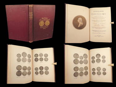
1886 COINS History of US Mint American Numismatics Thomas Jefferson BankingSchilb Antiquarian Rare Books4.8(428)See Sold PriceMar 10, 2024
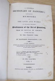
MATTHEW PILKINGTON General Dictionary Painters 2 Vol Set 1824 Calf BindingLuis Porretta Fine Arts4.3(10)See Sold PriceMar 02, 2024
American Revolution prints. 19th century. To include: 1) "The Death of General Montgomery". FrenchTremont Auctions4.5(297)See Sold PriceFeb 25, 2024
Pair of Early Railroad Maps - 1874 Delaware, Lackawanna & Western and 1876 Pennsylvania RailroadRail & Road Auctions4.6(165)See Sold PriceMar 07, 2024
Pair of Early Railroad Maps - 1862 Pittsburgh, Ft. Wayne & Chicago Railway and 1873 PennsylvaniaRail & Road Auctions4.6(165)See Sold PriceMar 07, 2024
1867 Map of the Railroads of The State of New YorkRail & Road Auctions4.6(165)See Sold PriceMar 08, 2024
VINTAGE SETH THOMAS TEMPUS FUGIT GRANDFATHER CLOCKLewis & Maese Antiques & Auction4.4(527)See Sold PriceFeb 25, 2024
[EDUCATION]. A pair of portraits of the Fisk Jubilee Singers [with:] photograph of the FiskFreeman's | Hindman4.4(1.6k)See Sold PriceFeb 27, 2024
Lewis Thomas Ives, Oil on Canvas Boy with HoopStefek's Auctioneers & Appraisers4.6(113)See Sold PriceFeb 28, 2024
Arrowsmith & Lewis - Map of PolynesiaTrillium Antique Prints & Rare Books4.5(32)See Sold PriceFeb 24, 2024
Arrowsmith & Lewis - Map of North AmericaTrillium Antique Prints & Rare Books4.5(32)See Sold PriceFeb 24, 2024
Arrowsmith & Lewis - Map of the World on Mercator's ProjectionTrillium Antique Prints & Rare Books4.5(32)See Sold PriceFeb 24, 2024
Arrowsmith & Lewis - Map of LouisianaTrillium Antique Prints & Rare Books4.5(32)See Sold PriceFeb 24, 2024
Arrowsmith & Lewis - Map of the United StatesTrillium Antique Prints & Rare Books4.5(32)See Sold PriceFeb 24, 2024
Putnam - First Map of the State of Ohio by Rufus PutnamTrillium Antique Prints & Rare Books4.5(32)See Sold PriceFeb 24, 2024
After Frederick Taylor, "Weighing the Deer"Old Kinderhook Auction Company4.6(217)See Sold PriceMar 05, 2024
Perry, Matthew C. 1856 Large Map. Shah Bay, Lew Chew I. JapanAlbion Auctions4.7(341)See Sold PriceMar 01, 2024
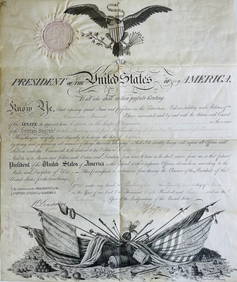
JEFFERSON THOMAS: (1743-1826)International Autograph Auctions Europe S.L.4.4(52)See Sold PriceMar 14, 2024


![[EDUCATION]. A pair of portraits of the Fisk Jubilee Singers [with:] photograph of the Fisk (1 of 3)](https://p1.liveauctioneers.com/197/319238/171467848_1_x.jpg?height=282&quality=70&version=1707520367)