ATLAS of ANTIENT GEOGRAPHY by SAMUEL BUTLER 1843John McInnis Auctioneers,LLC4.5(505)See Sold PriceFeb 24, 2024
18TH C. ANTIQUE MAP: FRENCH & INDIAN WAR, FRAMEDThomaston Place Auction Galleries4.4(393)See Sold PriceFeb 24, 2024
Rand McNally Railroad Map Cabinet w/ 21 Railroad MapsRail & Road Auctions4.6(165)See Sold PriceMar 08, 2024
Keith Haring - Ink on New York Map, Best Buddies, Inscribed, Signed, and DatedSapphire Auction Gallery4(67)See Sold PriceMar 02, 2024
LATE 17TH C. FRENCH MAP OF THE NEW WORLD BY ALEXIS-HUBERT JAILLOT (1632-1712)Thomaston Place Auction Galleries4.4(393)See Sold PriceFeb 24, 2024
Central Railroad of New Jersey Map of Sandy Hook Route-ca. 1903JM Hobby Supply and Railroad Artifact Auctions4.4(127)See Sold PriceFeb 24, 2024
Lot of Six Mixed Atlas Box Cars-HO Scale-New in BoxJM Hobby Supply and Railroad Artifact Auctions4.4(127)See Sold PriceFeb 25, 2024
Rand McNally/Santa Fe Railroad Map of Iowa-1912JM Hobby Supply and Railroad Artifact Auctions4.4(127)See Sold PriceFeb 24, 2024
NICOLAES VISSCHER (NETHERLANDS, 1618-1709) MAP OF THE NEW WORLDThomaston Place Auction Galleries4.4(393)See Sold PriceFeb 24, 2024
17TH C. WORLD MAP BY NICOLAES VISSCHER (NETHERLANDS, 1618-1709)Thomaston Place Auction Galleries4.4(393)See Sold PriceFeb 24, 2024
Lot of Six Mixed Atlas Cabooses-HO Scale-New in BoxJM Hobby Supply and Railroad Artifact Auctions4.4(127)See Sold PriceFeb 25, 2024
Letts: LONDON town city plan. Underground railways 1889TITLE/CONTENT OF MAP: 'London (West), London (East)' The map shows the early underground lines as well as mainline railways and stations, bus and tram routes, steamboat piers and routes on the Thames,See Sold Price
LONDON town city plan. Underground railways stationsTITLE/CONTENT OF MAP: 'London (West), London (East)' The map shows the early underground lines as well as mainline railways and stations, bus and tram routes, steamboat piers and routes on the Thames,See Sold Price
LONDON town city plan. Underground railways stationsTITLE/CONTENT OF MAP: 'London (West), London (East)' The map shows the early underground lines as well as mainline railways and stations, bus and tram routes, steamboat piers and routes on the Thames,See Sold Price
LONDON town city plan. Underground railways bus tramsTITLE/CONTENT OF MAP: 'London' The map shows the early underground lines as well as mainline railways and stations, and parishes. The Bricklayers Arms terminus is shown, although the station was closeSee Sold Price
BOSTON antique town city map plan. Charlestown. LETTS,TITLE/CONTENT OF MAP: 'Boston' Date: 1889 IMAGE SIZE: Approx 41.0 x 33.0cm, 16 x 13 inches (Large) TYPE: Antique colour atlas map CONDITION: Good; suitable for framing. However, please note: The imageSee Sold Price
BOSTON antique town city map plan. Charlestown. LETTS,TITLE/CONTENT OF MAP: 'Boston' DATE PRINTED: 1889 IMAGE SIZE: Approx 41.0 x 33.0cm, 16 x 13 inches (Large) TYPE: Antique colour atlas map CONDITION: Good; suitable for framing. VERSO: There is nothingSee Sold Price
BOSTON antique town city map plan. Charlestown. LETTS,TITLE/CONTENT OF MAP: 'Boston' DATE PRINTED: 1889 IMAGE SIZE: Approx 41.0 x 33.0cm, 16 x 13 inches (Large) TYPE: Antique colour atlas map CONDITION: Good; suitable for framing. VERSO: There is nothingSee Sold Price
PARIS antique town city map plan. Omnibus routes.TITLE/CONTENT OF MAP: 'Letts's map of the City of Paris' DATE PRINTED: 1889 IMAGE SIZE: Approx 40.5 x 59.5cm, 16 x 23.5 inches (Large); Please note that this is a folding map. TYPE: Antique colour atlSee Sold Price
DUBLIN antique town city map plan. Railways tram routesTITLE/CONTENT OF MAP: 'Plan of the City of Dublin' The top image on the right hand side shows the entire map. To view a close up of the map showing the level of printed detail, please click on the botSee Sold Price
DUBLIN antique town city map plan. Railways tram routesTITLE/CONTENT OF MAP: 'Plan of the City of Dublin' DATE PRINTED: 1883 IMAGE SIZE: Approx 36.5 x 43.5cm, 14.25 x 17 inches (Large); Please note that this is a folding map. TYPE: Antique colour atlas maSee Sold Price
LONDON antique town city map plan. Building profiles.TITLE/CONTENT OF MAP: 'LONDON' The top image on the right hand side shows the entire map. To view a close up of the map showing the level of printed detail, please click on the bottom image on the rigSee Sold Price
LONDON antique town city map plan. Building profiles.TITLE/CONTENT OF MAP: 'LONDON' This map is folding hence the centrefold line may show on the image below DATE PRINTED: This map was originally published by Baldwin & Cradock in 1836; this date is prinSee Sold Price
LONDON antique town city map plan. Building profiles.TITLE/CONTENT OF MAP: 'LONDON' DATE PRINTED: This map was originally published by Baldwin & Cradock in 1836; this date is printed on the map. This edition of the map was printed and published by ChapmSee Sold Price
LONDON antique town city map plan. Building profiles.TITLE/CONTENT OF MAP: 'LONDON' The top image on the right hand side shows the entire map. To view a close up of the map showing the level of printed detail, please click on the bottom image on the rigSee Sold Price
LONDON antique town city map plan. Building profiles.TITLE/CONTENT OF MAP: 'LONDON' DATE PRINTED: This map was originally published by Baldwin & Cradock in 1836; this date is printed on the map. This edition of the map was printed and published by ChapmSee Sold Price
LONDON antique town city map plan. Building profiles.TITLE/CONTENT OF MAP: 'LONDON' DATE PRINTED: This map was originally published by Baldwin & Cradock in 1836; this date is printed on the map. This edition of the map was printed and published by ChapmSee Sold Price
LONDON antique town city map plan. Building profiles.TITLE/CONTENT OF MAP: 'LONDON' This map is folding hence the centrefold line may show on the image below DATE PRINTED: This map was originally published by Baldwin & Cradock in 1836; this date is prinSee Sold Price
LONDON antique town city map plan. Original hand colour. LARGE. SDUK 1857Title: LONDON antique town city map plan. Original hand colour. LARGE. SDUK 1857 Description: LONDON' by B.R Davies (The date of September 1st 1856 is printed on the map. The map was printed in 1857).See Sold Price
SoldLetts: Calcutta Kolkata Antique City Map Plan, 1889Map: 'Plan of the City of Calcutta' Date Printed: 1889 Image Size: Approx 28.5 x 43.0cm, 11.25 x 16.75 inches (Large) Type: Antique colour atlas map Condition: Good; suitable for framing. Artist/CartoSee Sold Price
LONDON in 1843 antique town city map plan. LARGE 65x40TITLE/CONTENT OF MAP: 'LONDON 1843' DATE PRINTED: This map was originally published by Chapman & Hall in 1843; this date is printed on the map. This edition of the map was printed and published by ChaSee Sold Price
LONDON in 1843 antique town city map plan. LARGE 65x40TITLE/CONTENT OF MAP: 'LONDON 1843' The top image on the right hand side shows the entire map. To view a close up of the map showing the level of printed detail, please click on the bottom image on thSee Sold Price
LONDON in 1843 antique town city map plan. LARGE 65x40TITLE/CONTENT OF MAP: 'LONDON 1843' The top image on the right hand side shows the entire map. To view a close up of the map showing the level of printed detail, please click on the bottom image on thSee Sold Price
LONDON in 1843 antique town city map plan. LARGE 65x40TITLE/CONTENT OF MAP: 'LONDON 1843' The top image on the right hand side shows the entire map. To view a close up of the map showing the level of printed detail, please click on the bottom image on thSee Sold Price
LONDON in 1843 antique town city map plan. LARGE 65x40 cm. SDUK 1844 oldTitle: LONDON in 1843 antique town city map plan. LARGE 65x40 cm. SDUK 1844 old Description: LONDON 1843' by Drawn and Engraved by B R Davies (This map was originally published by Chapman & Hall in 18See Sold Price
Crams Railroad Map of New York-1881JM Hobby Supply and Railroad Artifact Auctions4.4(127)See Sold PriceFeb 24, 2024
Hammonds Map of Kentucky and Tennessee Railroads-1910JM Hobby Supply and Railroad Artifact Auctions4.4(127)See Sold PriceFeb 24, 2024
Kenyons Pocket Map and Shippers Guide of Wisconsin-1914JM Hobby Supply and Railroad Artifact Auctions4.4(127)See Sold PriceFeb 24, 2024
Rand McNally Railroad Map of Arizona-1909JM Hobby Supply and Railroad Artifact Auctions4.4(127)See Sold PriceFeb 24, 2024
Chicago St Paul and Kansas City RY Color Advertising PieceJM Hobby Supply and Railroad Artifact Auctions4.4(127)See Sold PriceFeb 24, 2024
MAP OF SALZBURG BY GEORGE BRAUN & FRANS HOGENBURG. 1588Thomaston Place Auction Galleries4.4(393)See Sold PriceFeb 24, 2024
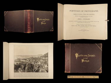
1894 World Photography Travel Cathedrals Paris Opera House Venice Canals IndiansSchilb Antiquarian Rare Books4.8(428)See Sold PriceMar 31, 2024
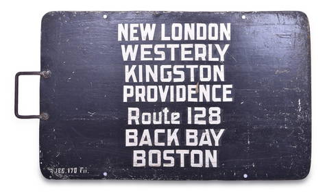
New York, New Haven, & Hartford Railroad Gate SignRail & Road Auctions4.6(165)See Sold PriceMar 08, 2024
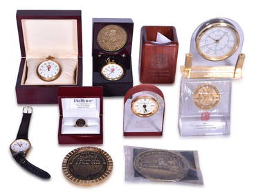
Kansas City Southern Railway Award and Promotional Items - Men's Ring, Pocket Watches, Clocks, BeltRail & Road Auctions4.6(165)See Sold PriceMar 08, 2024
Kansas City Southern Railway Pittsburgh Ticket Office Round Wax SealerRail & Road Auctions4.6(165)See Sold PriceMar 08, 2024
Twelve Pieces of Kansas City Southern Railroad China - Demitasse Set, Dinner Plates, Soup Bowl, andRail & Road Auctions4.6(165)See Sold PriceMar 08, 2024
1887 Appletons' General Guide to the United State and Canada Part IIRail & Road Auctions4.6(165)See Sold PriceMar 08, 2024
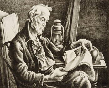
THOMAS HART BENTON (1889-1975) PENCIL SIGNED LITHOGRAPHSoulis Auctions4.8(953)See Sold PriceFeb 24, 2024
MONTAGUE BIRRELL BLACK (1884-1964) THE BLUE FUNNEL LINE. Circa 1920s.Swann Auction Galleries4.4(70)See Sold PriceFeb 29, 2024
FRENCH COLONIAL GUINEA. Guinee Française. Conakry city town ville plan 1929 mapJasper524.5(9.9k)See Sold PriceFeb 28, 2024
FRENCH COLONIAL GUINEA. Guinee Française. Conakry city town ville plan 1931 mapJasper524.5(9.9k)See Sold PriceFeb 28, 2024
Two Hand-Colored 19th Century Maps of New Orleans and Louisiana, Larger- H.- 12 1/2 in., W.- 15 1/2Crescent City Auction Gallery4.3(231)See Sold PriceMar 08, 2024