ATLAS of ANTIENT GEOGRAPHY by SAMUEL BUTLER 1843John McInnis Auctioneers,LLC4.5(505)See Sold PriceFeb 24, 2024
18TH C. ANTIQUE MAP: FRENCH & INDIAN WAR, FRAMEDThomaston Place Auction Galleries4.4(393)See Sold PriceFeb 24, 2024
Rand McNally Railroad Map Cabinet w/ 21 Railroad MapsRail & Road Auctions4.6(165)See Sold PriceMar 08, 2024
Keith Haring - Ink on New York Map, Best Buddies, Inscribed, Signed, and DatedSapphire Auction Gallery4.1(67)See Sold PriceMar 02, 2024
LATE 17TH C. FRENCH MAP OF THE NEW WORLD BY ALEXIS-HUBERT JAILLOT (1632-1712)Thomaston Place Auction Galleries4.4(393)See Sold PriceFeb 24, 2024
Central Railroad of New Jersey Map of Sandy Hook Route-ca. 1903JM Hobby Supply and Railroad Artifact Auctions4.4(127)See Sold PriceFeb 24, 2024
Lot of Six Mixed Atlas Box Cars-HO Scale-New in BoxJM Hobby Supply and Railroad Artifact Auctions4.4(127)See Sold PriceFeb 25, 2024
Rand McNally/Santa Fe Railroad Map of Iowa-1912JM Hobby Supply and Railroad Artifact Auctions4.4(127)See Sold PriceFeb 24, 2024
NICOLAES VISSCHER (NETHERLANDS, 1618-1709) MAP OF THE NEW WORLDThomaston Place Auction Galleries4.4(393)See Sold PriceFeb 24, 2024
17TH C. WORLD MAP BY NICOLAES VISSCHER (NETHERLANDS, 1618-1709)Thomaston Place Auction Galleries4.4(393)See Sold PriceFeb 24, 2024
Lot of Six Mixed Atlas Cabooses-HO Scale-New in BoxJM Hobby Supply and Railroad Artifact Auctions4.4(127)See Sold PriceFeb 25, 2024
SoldLaurie and Whittle Map of British ColoniesLAURIE, Robert (1755-1836) & WHITTLE, James (1757-1818). New and Correct Map of the British Colonies in North America with the Adjacent States of New England, Vermont, New York, Pennsylvania and New JSee Sold Price
SoldLAURIE & WHITTLE 1794 BRITISH COLONIES MAPLAURIE & WHITTLE 1794 BRITISH COLONIES MAP: Full title ''A New and Correct Map of the British Colonies in North America Comprehending Eastern Canada, with the Province of Quebec, New Brunswick, Nova SSee Sold Price
SoldLAURIE & WHITTLE. A New and Correct Map of theLAURIE & WHITTLE. A New and Correct Map of the British Colonies in North America. Double-page engraved map, 500x675, wide margins; hand-colored; minor chips or tears at edges (generally outside the plSee Sold Price
SoldLAURIE & WHITTLE BRITISH 18TH CENTURY MAP OF NORTHLAURIE & WHITTLE BRITISH 18TH CENTURY MAP OF NORTH AMERICA, hand-colored, title in cartouche to upper right corner "A NEW AND CORRECT MAP / OF THE / BRITISH COLONIES IN NORTH AMERICA / Comprehending /See Sold Price
SoldLaurie & Whittle (British, 1794-1812) Map of theLaurie & Whittle (British, 1794-1812)Map of the Empire of Japan Divided into Seven PrinSee Sold Price
SoldLaurie & Whittle Map of AmericaLAURIE & WHITTLE (Late 18th Century)The United States of America...Engraved map with original hand color in full.London: Laurie & Whittle, 1794.20 1/4" x 22 1/2" sheet.The first British map to show thSee Sold Price
SoldLaurie and Whittle MapLaurie and Whittle, "The United States of America with the British Possessions...divided with the French, also the Spanish Territories of Louisiana and Florida", London, 1794, hand-colored engraved maSee Sold Price
SoldMAP OF THE UNITED STATES "The United States ofMAP OF THE UNITED STATES "The United States of America", "with the British Possessions...and the Spanish Territories of Louisiana and Florida...as of 1783, London, Laurie & Whittle, May 1794", (note:See Sold Price
SoldAfter Samuel Dunn, New Chart of the World MapAfter Samuel Dunn (British, 18th century), "A New Chart of the World of Mercator's Projection: with The Tracks & Discoveries of the Latest Circumnavigators", published by Laurie & Whittle, London, EngSee Sold Price
SoldLAURIE, Robert (1755-1836) and James WHITTLE (d.1818)LAURIE, Robert (1755-1836) and James WHITTLE (d.1818) The United States of America with the British Possessions of Canada, Nova Scotia, New Brunswick and Newfoundland divided with the French, and theSee Sold Price
Homann: Antique Map British Colonies in North AmericaDominia Anglorum in America Septentrionali'. The map shows British Possessions in North America in four panels. Top left: The gulf of St Lawrence with Newfoundland, New Brunswick and Nova Scotia. TopSee Sold Price
SoldFramed Map British Colonies in N. AmericaFramed map The British Colonies in North America, engraved by William Faden, 1777, with polychrome landing scene (bottom right), color accents, matted and framed, 28" x 32'. CONDITION: Center fold linSee Sold Price
SoldLaurie & Whittle Map of North & Central ItalyLaurie & Whittle Map of North & Central Italy. Engraved map of North & Central Italy by D'Anville, published by Laurie & Whittle. Professionally matted and framed. Frame measures 38.5 inches x 31 inchSee Sold Price
Sold1794 Laurie & Whittle Map of the Caribbean, Mexico andTitle/Content of Map: 1794 Laurie & Whittle Map of the Caribbean, Mexico and Central America -- A New and Complete Map of the West Indies Comprehending All the Coasts and Islands Known by That Name bySee Sold Price
SoldGEORGIAN MAP, BRITISH COLONIES OF NORTH AMERICAHand-coloured, published by Thomas Kelly, London, from the first half of the 19thC., engraver unknown. Paper size: 8 3/8" x 10 3/8" / 21.3cm x 26.4cm.See Sold Price
Sold1794 Laurie & Whittle Map of Portugal and SouthwestTitle/ Content of Map: 1794 Laurie & Whittle Map of Portugal and Southwest Spain -- The Kingdoms of Portugal and Algarve Cartographer: J Lodge Year/Place: 1794, London Dimensions: 23.1 X 16.2 in. DescSee Sold Price
Sold1608 Laurie & Whittle Map of Portugal and Spain toTitle: 1608 Laurie & Whittle Map of Portugal and Spain to Gibraltar -- The Kingdoms of Portugal and Algarve from Zannoni's Map Cartographer: Laurie & Whittle Year / Place: 1608, London. Map DimensionSee Sold Price
SoldLaurie & Whittle Map of SardiniaLaurie & Whittle Map of Sardinia. Engraved map of Dominions of the King of Sardinia by Thomas Jeffreys, published by Laurie & Whittle. Professionally matted and framed. Frame measures 38.5 inches x 31See Sold Price
SoldLaurie & Whittle - Map of the North American CoastA New and Accurate Chart (From Captain Holland's Surveys) of the North American Coast for the Navigation Between the Gulf of Florida and Philadelphia, published by Robert Laurie and James Whittle, LonSee Sold Price
1794 Laurie & Whittle Map of Portugal and SouthwestTitle/Content of Map: 1794 Laurie & Whittle Map of Portugal and Southwest Spain -- The Kingdoms of Portugal and Algarve Date: 1794, London Cartographer: J Lodge Size: 23.1 X 16.2 in. This is a very niSee Sold Price
SoldLaurie & Whittle - Map of the North American CoastA New and Correct Chart from Captain Holland's Surveys of the North American Coast for the Navigation Between Halifax and Philadelphia, published by Robert Laurie and James Whittle, London, 1798-1800,See Sold Price
SoldLaurie & Whittle British (early 19th century)Laurie & Whittle British (early 19th century) PAIR WORKS: 'WATERLOO PLACE, PALL MALL, AND THE COLONNADE OF THE KINGS THEATRE, OPERA-HOUSE', and 'A VIEW OF THE WAREHOUSES & WEST-INDIA DOCK' colored engSee Sold Price
SoldLaurie & Whittle, Map "North and South America. AmericaLaurie & Whittle, Map "North and South America. America Divided into North and South with their Several Subdivisions and the Newest Discoveries." London: Laurie & Whittle, 1794. dated 20" x 20-1/2" siSee Sold Price
SoldLaurie & Whittle Map of the Kingdom of PolandLaurie & Whittle A new map of the Kingdom of Poland, with its dismembered provinces and the Kingdm. of Prussia,from A New Universal Atlas, with title cartouche, upper left, engraved map, withSee Sold Price
Jerusalem Map for British Soldiers in Palestine - WW2Levy Auction House4.3(11)See Sold PriceFeb 27, 2024
1937 Khartum Sudan First All Up Flight Airmail cover FFC to London EnglandMynt Auctions4.6(697)See Sold PriceFeb 24, 2024
1943 British SWA South WEst Africa Prisoner of War POW Cover Andalusia to TahitiMynt Auctions4.6(697)See Sold PriceFeb 26, 2024
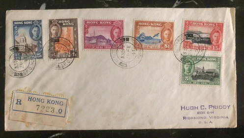
1941 Hong Kong First Day Cover FDC 100 Years British Colony Stamp Set MI 163-68Mynt Auctions4.6(697)See Sold PriceFeb 26, 2024
1940s Sudan Italian Prisoner of War POW Postcard Cover To Asmara Eritrea MedicalMynt Auctions4.6(697)See Sold PriceFeb 26, 2024
1919 Lome Togo Anglo French Occupation Gold Coast Cover to Buchs SwitzerlandMynt Auctions4.6(697)See Sold PriceFeb 26, 2024
1935 England Airmail Postcard Cover London to Njoro Kenya Colony British KUTMynt Auctions4.6(697)See Sold PriceFeb 29, 2024
AN ANTIQUE FOLDING MAP OF THE BRITISH ISLES DATED 1873Hutchinson Scott Auctioneers4.4(42)See Sold PriceFeb 28, 2024
Chatelain - 3 Maps of the British Isles (England, Ireland, Scotland)Trillium Antique Prints & Rare Books4.5(32)See Sold PriceFeb 24, 2024
De Jode, Rare, pub. 1593 - Map of the British Isles [England, Scotland, Ireland] (Angliae Scotiae etTrillium Antique Prints & Rare Books4.5(32)See Sold PriceFeb 24, 2024
Map: A 17thC engraved map of the British Isles titled A Generall Mapp of the Isles of GreatClaydon Auctioneers Ltd4.3(125)See Sold PriceFeb 26, 2024
1932 Juba Sudan First Flight Airmail Cover To Johannesburg South Africa 25 FlowMynt Auctions4.6(697)See Sold PriceMar 01, 2024
BRITISH AFRICAN COLONIES. West Africa Ascension St. Helena Mauritius 1876 mapJasper524.5(9.9k)See Sold PriceFeb 28, 2024
COLONIES FRANÇAISES en AFRIQUE. Africa Sénégal Madagascar. LEVASSEUR c1850 mapJasper524.5(9.9k)See Sold PriceFeb 28, 2024
Johnson's Africa. Colonies & tribes. Liberia Nile Delta Cape Colony 1866 mapJasper524.5(9.9k)See Sold PriceFeb 28, 2024
Stanford, Edward 1901 Large Map. Geological Map of the British IslesAlbion Auctions4.7(341)See Sold PriceMar 01, 2024
Stanford, Edward 1901 Large Map. Hydrographical Map of the British IslesAlbion Auctions4.7(341)See Sold PriceMar 01, 2024
Stanford, Edward 1901 Large Map. Stereographical Map of The British IslesAlbion Auctions4.7(341)See Sold PriceMar 01, 2024
Paterson & Mogg 1822 Pair of British Road Maps. Rye, Eastbourne, SouthamptonAlbion Auctions4.7(341)See Sold PriceMar 01, 2024
Paterson & Mogg 1822 Pair of British Road Maps. Deal, Hythe, Shoreham, ChichesterAlbion Auctions4.7(341)See Sold PriceMar 01, 2024
6 pcs Vintage Paper Maps. Vancouver Island, British Columbia. Upper Elk Creek Sheet. See pics.Crawford Family Auctions LLC4.6(122)See Sold PriceMay 25, 2024


![De Jode, Rare, pub. 1593 - Map of the British Isles [England, Scotland, Ireland] (Angliae Scotiae et (1 of 2)](https://p1.liveauctioneers.com/6581/319571/171593327_1_x.jpg?height=282&quality=70&version=1707853304)


