ATLAS of ANTIENT GEOGRAPHY by SAMUEL BUTLER 1843John McInnis Auctioneers,LLC4.5(505)See Sold PriceFeb 24, 2024
18TH C. ANTIQUE MAP: FRENCH & INDIAN WAR, FRAMEDThomaston Place Auction Galleries4.4(394)See Sold PriceFeb 24, 2024
Rand McNally Railroad Map Cabinet w/ 21 Railroad MapsRail & Road Auctions4.6(165)See Sold PriceMar 08, 2024
Keith Haring - Ink on New York Map, Best Buddies, Inscribed, Signed, and DatedSapphire Auction Gallery4.1(67)See Sold PriceMar 02, 2024
LATE 17TH C. FRENCH MAP OF THE NEW WORLD BY ALEXIS-HUBERT JAILLOT (1632-1712)Thomaston Place Auction Galleries4.4(394)See Sold PriceFeb 24, 2024
Central Railroad of New Jersey Map of Sandy Hook Route-ca. 1903JM Hobby Supply and Railroad Artifact Auctions4.4(127)See Sold PriceFeb 24, 2024
Lot of Six Mixed Atlas Box Cars-HO Scale-New in BoxJM Hobby Supply and Railroad Artifact Auctions4.4(127)See Sold PriceFeb 25, 2024
Rand McNally/Santa Fe Railroad Map of Iowa-1912JM Hobby Supply and Railroad Artifact Auctions4.4(127)See Sold PriceFeb 24, 2024
NICOLAES VISSCHER (NETHERLANDS, 1618-1709) MAP OF THE NEW WORLDThomaston Place Auction Galleries4.4(394)See Sold PriceFeb 24, 2024
17TH C. WORLD MAP BY NICOLAES VISSCHER (NETHERLANDS, 1618-1709)Thomaston Place Auction Galleries4.4(394)See Sold PriceFeb 24, 2024
Lot of Six Mixed Atlas Cabooses-HO Scale-New in BoxJM Hobby Supply and Railroad Artifact Auctions4.4(127)See Sold PriceFeb 25, 2024
Laurie & Whitle, "An Actual Survey of the Provinces ofLaurie & Whitle, "An Actual Survey of the Provinces of Bengal, Bohar, etc. by James Rennell from a map by Andrew Dury," 1794, in two parts, Each- H. - 21 1/2 in., W. - 28 3/4 in. (2 Pcs.)See Sold Price
SoldDury (Andrew) - An Actual Survey of the Provinces ofthe survey by Major James Rennell, Surveyor General to the honourable the East India Company, engraved map with original hand-colouring on 2 sheets, unjoined, approx 995 x 1500mm., if joined, the sheeSee Sold Price
SoldIndia.- Dury (Andrew) An Actual Survey of the ProvincesIndia.- Dury (Andrew) An Actual Survey of the Provinces of Bengal, Bahar &c., By Major James Rennell [...] published from a drawing by A. Dury, large two-sheet wall map of Bengal, illustrating the couSee Sold Price
SoldMAP, Guadeloupe, LaurieGuadeloupe. Richard Holmes Laurie, Guadaloupe, Done from Actual Surveys and Observations of the English, Whilst the Island Was in Their Possession, with Subsequent Improvements, 1830 (dated). Hand ColSee Sold Price
MAP - Tobago. JefferysTobago. Jefferys/Laurie & Whittle, Tobago from Actual Surveys and Observation, 1810 (dated). Hand Color. This classic map of Tobago illustrates the rapid development of sugar plantations. Each large dSee Sold Price
Sauthier's Map of New York 1776A Map of the Province of New-York Reduc'd from the large Drawing of that Province, Compiled from actual Surveys by Order of His Excellency William Tryon Esqr. Captain General & Governor of the Same, BSee Sold Price
SoldIndia.- Laurie & Whittle (publishers) A New Map of theIndia.- Laurie & Whittle (publishers) A New Map of the Jaghir Lands, on the Coast of Coromandel, The Territory Belonging To The East India Company Round Madras From An Actual Survey In The PossessionSee Sold Price
SoldIndia.- Laurie & Whittle (publishers) A New Map of theIndia.- Laurie & Whittle (publishers) A New Map of the Jaghir Lands, on the Coast of Coromandel, The Territory Belonging To The East India Company Round Madras From An Actual Survey In The PossessionSee Sold Price
SoldMontresor, Map of Province of New YorkMONTRESOR, John (1736-1799). A Map of the Province of New York with Part of Pensilvania and New England from an actual survey by Captain Montresor, Engineer, 1775. Engraved map with original color inSee Sold Price
SoldMONTRESOR, John. Map of the Province of New York,MONTRESOR, John. Map of the Province of New York, with Part of Pennsylvania, and New England...Map of the Province of New York, with Part of Pennsylvania, and New England, from an Actual SurveSee Sold Price
Laurie And WhittleLaurie And Whittle,A new Map of Ireland compiled from actual surveys and regulated by the latest astronomical observations by Joseph Enony, geographer,Published by Laurie and Whittle, 53 Fleet St. LonSee Sold Price
St. Vincent Survey, Thomas Jefferys 1794Title: St. Vincent from an actual Survey made in the year 1773, After the Treaty with the Caribs Subject: St. Vincent Maker: Thomas Jefferys Date: 1794, Laurie & Whittle: London Size: 24 x 18.2 inchesSee Sold Price
1774 Jeffrey's Map of the Most Inhabited Part of New"Containing the Provinces of Massachusets Bay and New Hampshire with the Colonies of Conecticut and Rhode Island Divided into Counties and Townships; the whole completed from Actual Surveys and its SiSee Sold Price
Montresor's mapping of the Hudson River watershedMONTRESOR, John (1736- 1799). A Map of the Province of New York with Part of Pensilvania and New England from an actual survey by Captain Montresor, Engineer, 1775. Engraved map with original color inSee Sold Price
John MontresorMap of the Province of New York, with Part of Pennsylvania , and New England, from an Actual Survey by Captain Montresor, Engineer, 1775. Copperplate engraving with original outline hand color Paper sSee Sold Price
SoldAntique Map of PennsylvaniaHand-painted copper engraved antique map, "A Map of Pennsylvania Exhibiting not only The Improved Parts of that Province, but also its Extensive Frontiers. Laid down from actual surveys, and chiefly fSee Sold Price
SoldDetailed colored map of Nova Scotia, 1861Heading: (Nova Scotia) Author: MacKinlay, A. & W. Title: MacKinlay's Map of the Province of Nova Scotia, Including the Island of Cape Breton. Compiled by Actual Recent Surveys Place Published: LiverpoSee Sold Price
SoldRARE H/C MANUSCRIPT ACTUAL SURVEY MAP STOCKPORTLOT (2) RARE H/C MANUSCRIPT ACTUAL SURVEY MAP STOCKPORT FOR JACOB DOWNING/WM.DRINKER W/ SECTION, BLOCK & LOT W/ PROPERTY OWNERS INCL. ROAD FROM STANTONVILLE TO STOCKPORT AND SAMUEL PRESTON'S PROPERTY,See Sold Price
SoldEARLY NEW YORK STATE ACTUAL SURVEY MAPEARLY NEW YORK STATE ACTUAL SURVEY MAP FOR COUNTIES ALONG SUSQUAHANNAH RIVER, INCL. CLINTON, CHENANGO, GREEN, ETC. 18TH C. 15 1/2" X 21"See Sold Price
Sold1795 Amos Doolittle “Vermont from Actual Survey”-1795 Amos Doolittle “Vermont from Actual Survey”- printed by Mathew Carey, wide margins, folds as issued, (tear, repair on fold at 9:00, tear on fold at 3:00, some staining), 15” x 12.25”, oveSee Sold Price
SoldAntique Map, County of Dorset from an Actual Survey,Greenwood & Co. (British, 19th century), "Map of the county of Dorset from an Actual Survey, made in the years 1825 & 1826," 1829, hand-colored copper-engraved map, engraved by H. Frost, published inSee Sold Price
SoldCary (John) Carys Actual Survey of the Country FifCary (John) Carys Actual Survey of the Country Fifteen Miles round London...,engraved vignette title, explanation, double-page general map and 50 detailed maps, all maps with partial hand-coloSee Sold Price
SoldMap of Vermont from actual Survey. "Engraved for CMap of Vermont from actual Survey. "Engraved for Carey's American Edition of Guthrie's Geography improved" some paper missing, not affecting map. browning. ss: 15"h x 12"wSee Sold Price
SoldBudgen (Richard) - An Actual Survey of the County of6 sheets, including a decorative cartouche with title, the dedication cartouche, 3 folding maps and 1 sheet of engravings, each sheet c.375 x 550mm, some browning and surface dirt, bound into contempoSee Sold Price
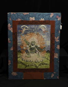
18/19thC Tibetan Thangka of a fierce deity. ActualThe Buddha Gallery4.4(29)See Sold PriceMar 13, 2024
19th 60's Chinese Food Stamps from different provinces and citiesFind Treasure4.1(15)See Sold PriceApr 07, 2024
BOTH TITLE PAGES OF COLLINS" COASTAL SURVEY, 1776, IN MATCHING FRAMESThomaston Place Auction Galleries4.4(394)See Sold PriceFeb 24, 2024
OGILVY & BOWEN c1736 Original Map of Oxfordshire Berkshire Etc.Luis Porretta Fine Arts4.3(10)See Sold PriceMar 02, 2024
MAP - Dufour, A. H. ( Malte / Brun ) :MAP - ESPAGNE PARTIE SUD DIVISEE EN PROVINCES ANCIENNES ( MAPLuis Porretta Fine Arts4.3(10)See Sold PriceMar 02, 2024
Neuweilers Beer Quart Cone Top PRETTY AND MINTY ACTUAL 215-13Morean Auctions4.5(33)See Sold PriceFeb 25, 2024
Perone Beer Quart Cone Top GRAIL CAN UNIQUE ACTUAL 217-7Morean Auctions4.5(33)See Sold PriceFeb 25, 2024
Fitzgerald Beer 1940s Ball Tap Knob ULTRA RARE ACTUAL 214Morean Auctions4.5(33)See Sold PriceFeb 25, 2024
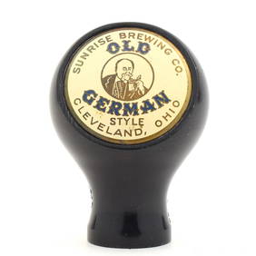
Old German Sunrise Brewing Ball Tap Knob RARE ACTUAL 492Morean Auctions4.5(33)See Sold PriceFeb 25, 2024
Utagawa HIROSHIGE (1797-1858): Views of the Provinces, Bird & Flowers, a.o. / Limited edition set,Jasper524.5(9.9k)See Sold PriceFeb 28, 2024
Hiroshige Woodblock - Tanba Province: KanegasakaFloating World Auctions4.7(236)See Sold PriceMar 01, 2024
Utagawa Toyokuni III Woodblock - Settsu ProvinceFloating World Auctions4.7(236)See Sold PriceMar 01, 2024
Laurie Hogin (American, b. 1963) Untitled (Revolution Horses) #2, 1992Freeman's | Hindman4.4(1.6k)See Sold PriceMar 07, 2024
Chinese scroll, bird on a branch, signed, scroll is 78.5" long, 24.25" wide, actual scene is 44.75"Hudson Valley Auctioneers LLC Beacon NY4.7(561)See Sold PriceFeb 26, 2024
Set of 4 Maps - Netherlands - Seven United Provinces - Germany - Sweden, Denmark, Norway, FinlandProverde Auctions4.3(3)See Sold PriceFeb 28, 2024
Hiroshige (Japanese) Woodblock Print, Hoki ProvinceLion and Unicorn4.7(1.9k)See Sold PriceMar 14, 2024