ATLAS of ANTIENT GEOGRAPHY by SAMUEL BUTLER 1843John McInnis Auctioneers,LLC4.5(505)See Sold PriceFeb 24, 2024
18TH C. ANTIQUE MAP: FRENCH & INDIAN WAR, FRAMEDThomaston Place Auction Galleries4.4(393)See Sold PriceFeb 24, 2024
Rand McNally Railroad Map Cabinet w/ 21 Railroad MapsRail & Road Auctions4.6(165)See Sold PriceMar 08, 2024
Keith Haring - Ink on New York Map, Best Buddies, Inscribed, Signed, and DatedSapphire Auction Gallery4(67)See Sold PriceMar 02, 2024
LATE 17TH C. FRENCH MAP OF THE NEW WORLD BY ALEXIS-HUBERT JAILLOT (1632-1712)Thomaston Place Auction Galleries4.4(393)See Sold PriceFeb 24, 2024
Central Railroad of New Jersey Map of Sandy Hook Route-ca. 1903JM Hobby Supply and Railroad Artifact Auctions4.4(127)See Sold PriceFeb 24, 2024
Lot of Six Mixed Atlas Box Cars-HO Scale-New in BoxJM Hobby Supply and Railroad Artifact Auctions4.4(127)See Sold PriceFeb 25, 2024
Rand McNally/Santa Fe Railroad Map of Iowa-1912JM Hobby Supply and Railroad Artifact Auctions4.4(127)See Sold PriceFeb 24, 2024
NICOLAES VISSCHER (NETHERLANDS, 1618-1709) MAP OF THE NEW WORLDThomaston Place Auction Galleries4.4(393)See Sold PriceFeb 24, 2024
17TH C. WORLD MAP BY NICOLAES VISSCHER (NETHERLANDS, 1618-1709)Thomaston Place Auction Galleries4.4(393)See Sold PriceFeb 24, 2024
Lot of Six Mixed Atlas Cabooses-HO Scale-New in BoxJM Hobby Supply and Railroad Artifact Auctions4.4(127)See Sold PriceFeb 25, 2024
SoldLarge scale framed map of FranceLarge scale framed map of France. 56 1/2"h x 64 1/2"wSee Sold Price
Large framed and matted hand-colored map of FrancLarge framed and matted hand-colored map of France by Nocolaum Visser, c.1680, with extensive detailing. 23”x29”See Sold Price
Large Framed Map of TX RailroadsVintage large scale map of Tx showing the existing railroads and topographical features. Measures 26x37 inches. Archival framing. Good clean condition and easy to read.See Sold Price
Large, framed map of Gaul, Wells c1700Double page copper engraved map of France engraved by Robert Spofforth and published for "A new sett of maps both of antient and present geography.” Shows ancient political and administrative divisiSee Sold Price
SoldLarge Scale City Of New Haven Connecticut Map 1851City of New Haven Connecticut map. Framed, and glued to board. Published by Colins & Clark, Philadelphia, Pennsylvania 1851. Overall condition is fair, with uniform toning. See Sold Price
SoldVintage Map Of Paris France C 1944Vintage Map Of Paris France Scale 1:1000 C 1944 A vintage framed map of Paris France in a wood toned frame. Creases and foxing to paper. Not examined out of frame. Vintage maps, collectible. MeasuresSee Sold Price
SoldFramed Christopher Greenwood Map of London printed inMap of London from an actual survey made in the years 1824, 1825 & 1826, Published by the Proprietors, Greenwood, Pringle & Co, London, Engraved by James & Josiah Neele, fine large scale map with contSee Sold Price
SoldSanson Map of the WorldMappe-Monde Geo-Hydrographique... Nicolas Sanson (1600-1667). Engraved map with original hand color in outline. Paris: A. Jaillot, c. 1691. 25 x 38 inches sheet, 35 x 48 inches framed. Large-scale worSee Sold Price
SoldLarge-Scale Vintage JASPER JOHNS Exhibition PosterLarge-scale vintage and framed JASPER JOHNS exhibition poster for the Museum of Modern Art in New York. Poster features a print of Johns’ 1961 oil painting titled ‘Map’. Image depicts an abstracSee Sold Price
SoldGeological Map of Long and Staten Island with EnvironsWilliam W. Mather (1804-1859). Hand-colored Lithograph. New York, 1842. 25 1/8 x 53 3/4 inches, 30 x 58 3/8 inches framed. Magnificent 1842 Large-Scale Geological Map of Long Island. This 1842 map wasSee Sold Price
SoldSigned Footballers of the World framed display,Signed Footballers of the World framed display, comprising a large scale map of the world applied with 20 banknotes each bearing the autograph of an international footballing legend and accompanied bySee Sold Price
Old Master Style Framed Giclee on Canvas World MapOld Master Style Framed Giclee on Canvas World Map. Large scale decorator piece. Measures 55 x 50 inches. From a designer decorated Connecticut home.See Sold Price
SoldOld Master Style Framed Giclee on Canvas World MapOld Master Style Framed Giclee on Canvas World Map. Large scale decorator piece. Measures 55 x 50 inches. From a designer decorated Connecticut home.See Sold Price
SoldMontanus 1673 Map of South America & AmazonMontanus and Dapper. Based off Gerritsz's work. Richly embellished with large title cartouche and distance scale along with Native Brazilian nobles. Conservation framed. MEASUREMENTS: Map 14" high x 1See Sold Price
SoldWW2 'WESTERN FRONT' in 1940. Bird's eye view before invasion of France 1940 mapTITLE/CONTENT OF MAP: 'Daily Mail Air-View Map of the Western Front' DATE PRINTED: 1940 IMAGE SIZE: Approx 97.0 x 74.0cm, 38 x 29 inches (Large) TYPE: Vintage colour map; Scale 10 miles: 1 inch CONDITSee Sold Price
SoldNorth Central California mapFramed oil on panel, Whimsical large-scale map of North Central California, San Francisco to Lake Tahoe, by Stephanie Taylor (American), overall: 70''h x 56''wSee Sold Price
SoldFramed Photograph - Mixed Dirigible Malecot of 1908**Originally Listed At $200** Europe, France, first half of the 20th century from ca. 1908 photograph. Framed and matted under glass, a limited edition large scale black and white chromogenic print enSee Sold Price
SoldMartha's Vineyard mapNewer copy of a 1913 G.W. Eldridge map of Martha's Vineyard. Large scale with descriptive detail including villages, roads, bays, etc... matted and framed. 35" high x 46" wideSee Sold Price
Framed Photograph - Mixed Dirigible Malecot of 1908**Originally Listed At $200** Europe, France, first half of the 20th century from ca. 1908 photograph. Framed and matted under glass, a limited edition large scale black and white chromogenic print frSee Sold Price
Framed Photograph - Mixed Dirigible Malecot of 1908Europe, France, first half of the 20th century from ca. 1908 photograph. Framed and matted under glass, a limited edition large scale black and white chromogenic print from a famous photograph, most lSee Sold Price
Framed Photograph "Accident de la 'Fregate' en 1910"Europe, France, first half of the 20th century black and white chromogenic print from ca. 1910 photograph. Framed and matted under glass, a limited edition, large scale, black-and-white chromogenic prSee Sold Price
SoldLarge-scale world map in two hemispheres prepared by N.Mappe-Monde Geo-Hydrographique...Alexis-Hubert Jaillot (1632-1712). Engraved map with original hand color. Amsterdam: P. Mortier, 1691. 24 1/2 x 38 1/4 inches sheet, 35 1/2 x 49 1/2 inches framed. LarSee Sold Price
SoldHolzel Largescale Chromo of South AmericaPlateau van Anahuac, #9. Eduard Holzel (1817-1885). from Geographische Charakterbilder. Chromolithograph Wien: E. Holzel, 1887. 23 1/4 x 30 3/4 inches sheet, 34 1/2 x 42 1/2 inches framed. Extremely rSee Sold Price
SoldHolzel Largescale Chromo of South AmericaMangrovekuste in Venezuela, #21. Eduard Holzel (1817-1885). from Geographische Charakterbilder. Chromolithograph Wien: E. Holzel, 1887. 23 1/4 x 30 3/4 inches sheet, 34 1/2 x 42 1/2 inches framed. ExtSee Sold Price
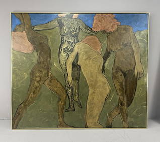
Phillip Vander Weg (American b.1943) PaintingEpic Auctions and Estate Sales4.6(210)See Sold PriceMar 02, 2024
Phillip Vander Weg "Dance #2" Painting 83.5" x 71"Epic Auctions and Estate Sales4.6(210)See Sold PriceMar 02, 2024
1867 Map of the Railroads of The State of New YorkRail & Road Auctions4.6(165)See Sold PriceMar 08, 2024
RARE Georges Fouille "Trompette des Gardes"Old Toy Soldier Auctions USA4.8(1.1k)See Sold PriceMar 15, 2024
1736 LARGE MAP OF SILESIA POLAND OPPAVIENSIS antique 25 by 34 3/4"Jasper524.5(9.9k)See Sold PriceFeb 27, 2024
1736 LARGE MAP OF SILESIA POLAND KARNOVIENSIS antique 25 x 4 3/4" Duchy of KrnovJasper524.5(9.9k)See Sold PriceFeb 27, 2024
WEST AFRICA. French. Gold Coast Ghana. inset Gambia; Sierra Leone 1920 mapJasper524.5(9.9k)See Sold PriceFeb 28, 2024
NAMIBIA. South West Africa protectorate. HARMSWORTH 1920 old antique map chartJasper524.5(9.9k)See Sold PriceFeb 28, 2024
MEDITERRANEAN.Tunisia & Libyan coast.Sicily.Gulf of Sirte.BARTHOLOMEW 1952 mapJasper524.5(9.9k)See Sold PriceFeb 28, 2024
Chester Fields Building For The Future Bald Eagle Large Scale Bronze SculptureOAB Auctions4.2(97)See Sold PriceMar 10, 2024