ATLAS of ANTIENT GEOGRAPHY by SAMUEL BUTLER 1843John McInnis Auctioneers,LLC4.5(505)See Sold PriceFeb 24, 2024
18TH C. ANTIQUE MAP: FRENCH & INDIAN WAR, FRAMEDThomaston Place Auction Galleries4.4(393)See Sold PriceFeb 24, 2024
Rand McNally Railroad Map Cabinet w/ 21 Railroad MapsRail & Road Auctions4.6(165)See Sold PriceMar 08, 2024
Keith Haring - Ink on New York Map, Best Buddies, Inscribed, Signed, and DatedSapphire Auction Gallery4(67)See Sold PriceMar 02, 2024
LATE 17TH C. FRENCH MAP OF THE NEW WORLD BY ALEXIS-HUBERT JAILLOT (1632-1712)Thomaston Place Auction Galleries4.4(393)See Sold PriceFeb 24, 2024
Central Railroad of New Jersey Map of Sandy Hook Route-ca. 1903JM Hobby Supply and Railroad Artifact Auctions4.4(127)See Sold PriceFeb 24, 2024
Lot of Six Mixed Atlas Box Cars-HO Scale-New in BoxJM Hobby Supply and Railroad Artifact Auctions4.4(127)See Sold PriceFeb 25, 2024
Rand McNally/Santa Fe Railroad Map of Iowa-1912JM Hobby Supply and Railroad Artifact Auctions4.4(127)See Sold PriceFeb 24, 2024
NICOLAES VISSCHER (NETHERLANDS, 1618-1709) MAP OF THE NEW WORLDThomaston Place Auction Galleries4.4(393)See Sold PriceFeb 24, 2024
17TH C. WORLD MAP BY NICOLAES VISSCHER (NETHERLANDS, 1618-1709)Thomaston Place Auction Galleries4.4(393)See Sold PriceFeb 24, 2024
Lot of Six Mixed Atlas Cabooses-HO Scale-New in BoxJM Hobby Supply and Railroad Artifact Auctions4.4(127)See Sold PriceFeb 25, 2024
SoldLarge map of Sherman's operations in Civil WarHeading: (Civil War) Author: Title: Military Map Showing the Marches of the United States Forces Under the Command of Maj. Genl. W.T. Sherman U.S.A. during the Years 1863, 1864, and 1865… Place PubSee Sold Price
UNITED STATES WAR DEPARTMENT - CIVIL WAR MAP SHOWINGUnited States War Department - Civil War Map Showing The Operations Of The Armies Against Richmond And Petersburg, 1865 - 29 3/4 X 40 In. - Giclée On Canvas - Museum Wrapped - Large Piece Of Art - ThSee Sold Price
UNITED STATES WAR DEPARTMENT - CIVIL WAR MAP SHOWINGUnited States War Department - Civil War Map Showing The Operations Of The Armies Against Richmond And Petersburg, 1865 - 29 3/4 X 40 In. - Giclée On Canvas - Museum Wrapped - Large Piece Of Art - ThSee Sold Price
United States War Department - Civil War Map ShowingUnited States War Department - Civil War Map Showing The Operations Of The Armies Against Richmond And Petersburg, 1865 - 29 3/4 X 40 In. - Giclée On Canvas - Museum Wrapped - Large Piece Of Art - ThSee Sold Price
Sold(CIVIL WAR.) Kossak, William. Military Map sho(CIVIL WAR.) Kossak, William. Military Map showing the Marches of the United States Forces under Command of Maj. Genl. W. T. Sherman during the Years 1863, 1864, 1865. Large folding lithographed map,See Sold Price
1863 Civil War map of Mississippi RiverOriginal and authentic 1863 “Map of Mississippi, Showing the Field Operations of Generals Sherman, Grant and Banks.” Published at the beginning of 1863 in Harper’s Weekly. Small piece missing frSee Sold Price
Sold"The Atlanta Campaign", Framed 1874 Civil War MapAmerican, last quarter 19th century. "Map IV Illustrating the Military Operations of The Atlanta Campaign", lithograph on paper, published by American Photo-Lithographic Co. (New York) in 1874. LargeSee Sold Price
Sold1874 General J.E. Johnston Military Ops Civil War 1 Ed.1874 General Joseph E. Johnston Narrative of Military Operations Civil War. Large Hardcover Book (6 1/2 x9 1/4") bound in brown gilt-stamped decorative Cloth. Narrative of Military Operations DirectedSee Sold Price
Large 1864 U. S. map showing Civil War fortsJohnson’s great map of the United States produced at a time when the outcome of the Civil War was still in doubt. Many forts are located along the East Coast, indicating how the war was on everySee Sold Price
SoldLarge Civil War map of United States 1863Heading: (United States - Civil War) Author: Lloyd, James T. Title: Lloyd's New Map of the United States, the Canadas and New Brunswick from the Latest Surveys Showing Every Railroad & Station FinisheSee Sold Price
SoldCIVIL WAR SHERMAN'S MARCH MAP FOLIO OF ATLANTAFramed plate 16 map of General Sherman's "March to the Sea" Atlanta and North Georgia section, taken from the 1864 Coast Survey, including frame measures 24 by 20 inches, and is very good.See Sold Price
Large Civil War map of the United States. ETTLING.TITLE/CONTENT OF MAP: 'Map of the United States of North America, Upper & Lower Canada, New Brunwick, Nova Scotia & British Columbia. Mexico, Cuba, Jamaica, St. Domingo and the Baham Islands by T EttlSee Sold Price
Large Civil War map of the United States. ETTLING.TITLE/CONTENT OF MAP: 'Map of the United States of North America, Upper & Lower Canada, New Brunwick, Nova Scotia & British Columbia. Mexico, Cuba, Jamaica, St. Domingo and the Baham Islands by T EttlSee Sold Price
Civil War Battles Map 20th Army Corps 1864This large Civil War map, 31" x 20 " framed, was part of the "Official Records of the Union and Confederate Army," a massive effort of over 100 volumes produced by the U. S. Government after the war.See Sold Price
MAP antique SAVANNAH GA GENERAL SHERMAN ARMY CIVIL WAROriginal Lithograph Plate LXX (70) of the 175 Plates of The Official Folio Historical Record of The Official Atlas to Accompany the Official Records of the Union and Confederate Armies, Ordered by ActSee Sold Price
MAP antique SAVANNAH GA GENERAL SHERMAN ARMY CIVIL WAROriginal Lithograph Plate LXX (70) of the 175 Plates of The Official Folio Historical Record of The Official Atlas to Accompany the Official Records of the Union and Confederate Armies, Ordered by ActSee Sold Price
SoldLarge map of U.S. at start of Civil WarHeading: Author: Stanford, Edward Title: Stanford's Railway and County Map of the United States and Territories Place Published: London Publisher: Date Published: 1861 Description:See Sold Price
SoldCIVIL WAR SHERMAN'S MARCH FOLDING MAPCIVIL WAR SHERMAN'S MARCH FOLDING MAP "Military Map Showing The Marches Of The United States Forces Under Command of Maj. Genl. W. T. Sherman. U. S. A. During The Years 1863, 1864, 1865", published 18See Sold Price
Decorative Historic Civil War Large Pocket Map.Phelps & Watson (fl. 1860's). Phelps & Watson's Historical and Military Map of the Border & Southern States. Lithographed map with orignal hand color. Phelps & Watson, 1863. 25½" x 35½" Map showSee Sold Price
Decorative Historical Civil War Large Pocket MapPhelps & Watson (fl. 1860's). Phelps & Watson's Historical and Military Map of the Border & Southern States. Lithographed map. Phelps & Watson, 1863. 25½ x 35½" sheet. Map showing from PA to NESee Sold Price
Sold(CIVIL WAR, MAP) The Historical Map. Indianapolis,(CIVIL WAR, MAP) The Historical Map. Indianapolis: Asher, 1862. 12mo, red cloth over printed blue paper boards. 56 pp., with large fold-out color map of the Civil War and four black and white in-textSee Sold Price
American Civil War.- Poe (Capt O.E.) U.S Eng. MapAmerican Civil War.- Poe (Capt O.E.) U.S Eng. Map 1 Illustrating the Military Operations of the Atlanta Campaign,lithographed military map, depicting civil war operations, battlefields, positiSee Sold Price
SoldAmerican Civil War.- Poe (Capt O.E.) U.S Eng. MapAmerican Civil War.- Poe (Capt O.E.) U.S Eng. Map 1 Illustrating the Military Operations of the Atlanta Campaign,lithographed military map, depicting civil war operations, battlefields, positiSee Sold Price
Large Civil War era mapHeading: Author: Lloyd, James T. Title: Lloyd's New Map of the United States the Canadas and New Brunswick From the latest Surveys Showing Every Railroad & Station Finished to June 1863 and The AtlanSee Sold Price
1885 CIVIL WAR 1ed Famous Memoirs US Grant Sheridan Sherman 6v RARE LOT MapsSchilb Antiquarian Rare Books4.8(428)See Sold PriceMar 10, 2024
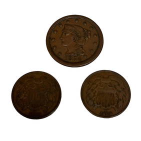
Two US 2 Cent Coins and 1854 Large One CentPremier Auction Galleries4.4(331)See Sold PriceMar 09, 2024
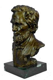
Large US President Abraham Lincoln Bronze Bust StatueWeatherham Estate Treasures3.9(159)See Sold PriceMar 07, 2024
Large lot of assorted prints. 18th-20th century. To include: North American and other maps, CivilTremont Auctions4.5(297)See Sold PriceFeb 25, 2024
Civil War Map, Positions of the Army of the Ohio Front oh Dalton GA Dated 1864 34"L x 24"TSwisher Bros. Auction LLC4.4(255)See Sold PriceFeb 24, 2024
Civil War Map, Positions of the 16th Army Corps Dated 1864 34"L x 24"TSwisher Bros. Auction LLC4.4(255)See Sold PriceFeb 24, 2024
1864 Civil War Accounts 1ed Gettysburg Vicksburg McClellan Sherman Bugle BlastSchilb Antiquarian Rare Books4.8(428)See Sold PriceMar 31, 2024
1900 Civil War Secret Service Lincoln Assassination National Detective PoliceSchilb Antiquarian Rare Books4.8(428)See Sold PriceMar 31, 2024
Cram's Global War Atlas 1939 Maps WWIINorth American Artifact Auctions4.7(198)See Sold PriceApr 20, 2024
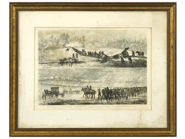
ANTIQUE AMERICAN CIVIL WAR ETCHINGS BY EDWIN FORBESAntique Arena Inc.4.5(878)See Sold PriceFeb 24, 2024
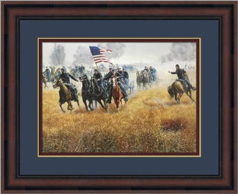
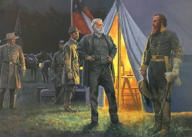
Mort Kunstler Civil War Large Print - The Return Of Stuart Custom FramedMynt Auctions4.6(697)See Sold PriceFeb 27, 2024
[CIVIL WAR]. WILD, Edward Augustus (1825-1891). Collection of items related to abolitionist,Freeman's | Hindman4.4(1.6k)See Sold PriceFeb 27, 2024
[BUFFALO SOLDIERS]. A large collection of photographs and documents related to 19th-20th centuryFreeman's | Hindman4.4(1.6k)See Sold PriceFeb 27, 2024
First World War.- Petre (F.Loraine), Wilfrid Ewart & Major General Lowther. The Scots Guards in theForum Auctions4.3(53)See Sold PriceFeb 29, 2024
Mort Kunstler Civil War Large Print Dilger at Gettysburg Custom FramedMynt Auctions4.6(697)See Sold PriceMar 02, 2024
Operation Torch Nov 1942-May 1943. World War 2. Western Mediterranean 1966 mapJasper524.5(9.9k)See Sold PriceFeb 28, 2024
Antique Rail Road Tickets and Passes of the Peoria, Pekin and Jacksonville R.R.-Cairo and VincennesJasper524.5(9.9k)See Sold PriceMar 07, 2024
David Moriarty Large Original Oil Painting On Board Landscape Signed Framed ArtOAB Auctions4.2(97)See Sold PriceMar 10, 2024


![[CIVIL WAR]. WILD, Edward Augustus (1825-1891). Collection of items related to abolitionist, (1 of 4)](https://p1.liveauctioneers.com/197/319238/171468118_1_x.jpg?height=282&quality=70&version=1707520367)
![[BUFFALO SOLDIERS]. A large collection of photographs and documents related to 19th-20th century (1 of 6)](https://p1.liveauctioneers.com/197/319238/171468141_1_x.jpg?height=282&quality=70&version=1707520367)