MATTHEWS c1856 Map Of Upper Canada Ontario Indian Land Agency Divisions Scarce!Luis Porretta Fine Arts4.3(10)See Sold PriceMar 02, 2024
DEVINE c1856 Dr Salters Map Of Lake Huron Ontario Indian Lands etc. No. 7 ScarceLuis Porretta Fine Arts4.3(10)See Sold PriceMar 02, 2024
DUNLEVIE c1856 Map Counties Of Gaspe & Bonaventure Quebec Canada SCARCE! #1Luis Porretta Fine Arts4.3(10)See Sold PriceMar 02, 2024
DUNLEVIE c1856 Map Counties Of Gaspe & Bonaventure Quebec Canada SCARCE! #2Luis Porretta Fine Arts4.3(10)See Sold PriceMar 02, 2024
Map UNITED COUNTIES LEEDS & GRENVILLE by Walling 1861 Rare Canada Map 5ft x 5ftLuis Porretta Fine Arts4.3(10)See Sold PriceMar 02, 2024
Ambroise TARDIEU c1822 Map Venice Napoleon Italian Campaign 17" x 11"Luis Porretta Fine Arts4.3(10)See Sold PriceMar 02, 2024
Large Format Map of the Manhattan Grid System by BurrBURR, David (1803-1875). Map of the City and County of New York with the Adjacent Country. Engraved map with original hand color. Ithaca, NY: Stone & Clark, 1839. 20 1/2" x 50 1/2" visible, 35" x 64"See Sold Price
Sold1872 Northern Pacific Railroad System MapNorthern Pacific Railroad large format system map: "Map of the Northern Pacific Railroad and Tributary County; 1872. Unframed. CONDITION: fold lines as issued; moderate toning throughout; laid down upSee Sold Price
SoldPenna. Central Rail Road System Map (1871)Pennsylvania Central Rail Road large format system map: "Map of Pennsylvania Central Rail Road and Its Connecting Lines", April 1, 1871, with elapsed time and fare tables, [Note: The Penna. Railroad sSee Sold Price
Scarce and large RR system map of Eastern Texas, 1898Highly informative, scarce large format map of Eastern Texas showing the extensive rail system in the state toward the end of the 19th century. From George F. Cram’s 1898 Bankers and Brokers RaiSee Sold Price
SoldPRE WWII OFFICIAL BOEING PHOTOGRAPH LOT28 Official Boeing Corporation c1920s/30s large format 9.75" x 7.75" photographs showing Boeing aircraft including planes in flight as well as plant assembly. Also included are 4 Boeing systems maps.See Sold Price
SoldScarce 1864 and 1866 Dripps maps of NYCDetailed and scarce large format 1864 and 1866 maps of New York City and Vicinity by Matthew Dripps, both appearing in Valentine's Manual. The 1864 map covers the entire island of Manhattan as well asSee Sold Price
Double-page RR map of Michigan/Wisconsin, 1874Large format, two-page vintage map of northern Great Lakes states. Shows railway system throughout the states at that time. Counties are distinguished by full and original hand coloring done at the tiSee Sold Price
SoldLARGE FORMAT MAP OR PRINT DISPLAYMeasures 36 x 33.5 x 33.5 inches, display only - no contents.See Sold Price
SoldBradford Atlas with Large-Format Map of TexasBradford Atlas with the Large-Format Map of Texas 3. [ATLAS]. BRADFORD, T[homas] G[amaliel] & S[amuel] G[riswold] Goodrich. A Universal, Illustrated Atlas, Exhibiting a Geographical, Statistical, andSee Sold Price
SoldLarge Format Map of BostonLarge map of Boston in burlwood frame. Modern copy showing Downtown and South Boston, Dorchester Bay, Quincy Bay, the South Shore, Cohasset, Duxbury, and onward to Cape Cod and Provincetown. Overall dSee Sold Price
SoldRare Large Format Map of New York City, 1876“Map of New York City South of 135th Street, Published by Matthew Dripps, 1876, 103 Fulton St.”, single sheet lithographic map with hand coloring, “showing new arrangement, docks, piers anSee Sold Price
SoldAntique large format map: "L'Archiduchae D'AustricAntique large format map: "L'Archiduchae D'Austriche", Circa 1692, Sanson, 24.5" x 37" (sheet)See Sold Price
SoldAntique large format map: "Germania in Priscas SuaAntique large format map: "Germania in Priscas Suas", 18th century, 21.5" x 37.5" (sheet)See Sold Price
SoldJOHN CARYA New Map of Italy, Including The Islands of Sicily, Sardinia and Corsica, with the Post Roads… 1799 Hand Colored engraving on paper Dimensions: 20" x 23" Note: "Gorgeous large format map of Italy,See Sold Price
Colton: Map of Minnesota, 1867Huge 1867 Minnesota map by Colton. 17 x 24.25. Very fine example of this early large format map. Finely engraved map of the state with inset of the north-eastern portion at upper right. Highly detaileSee Sold Price
Sold1849 India Shewing The Post Roads And Dawk StationsThis remarkably detailed large format map of India and parts of bordering countries highlights the means of transportation in mid-19th century India of both people and goods in the vast region depicteSee Sold Price
SoldLous Charles Desnos Map of Paris 1766Louis Charles Desnos (1725-1805), "Nouveau Plan de Paris, ses Faubourgs, et ses Environs," Paris, 1766. Decorative hand colored engraving large format map of Paris, showing a highly detailed treatmentSee Sold Price
Sold1813 Pinkerton Map of the Arabian Peninsula and the RedTitle/Content of Map: 1813 Pinkerton Map of the Arabian Peninsula and the Red Sea -- Arabia Date: 1813, London Cartographer: J Pinkerton Size: 20 X 28 in. This is a stunning large format map of the ArSee Sold Price
Extremely scarce and early map of Ohio, M. Carey 1814One of the most influential early maps of Ohio and the first large format map of Ohio to appear in an atlas. This 1816 example is the identical map that appeared in Carey’s 1814 General Atlas. TSee Sold Price
Sold1856 Map of the State of FloridaApproved by the Surveyor General on October 1st, of 1856, this large format map of Florida was part of an annual report. Showing great detail of coastal regions and towns, with counties listed in largSee Sold Price
SoldRand McNally & Co: Map of Brooklyn & Vicinity, 1903Rand McNally & Co’s Map of Brooklyn & Vicinity, 1903. 19 x 26.25 inches. Rand McNally's huge map of Brooklyn is the same as the only large format map of Brooklyn to appear in a general Commercial AtSee Sold Price
Scarce RR map of Oklahoma/Indian Ters. – 1897Large format map of the rapidly changing neighboring territories. Oklahoma Territory still showing several native reservations, mostly around present day Ponca City, and a single letter named county sSee Sold Price
SoldRussia.- Jaillot (Alexis-Hubert) La Russie Blanche ouRussia.- Jaillot (Alexis-Hubert) La Russie Blanche ou Moscovie Divisee Suivant l'Estendue Des Royaumes Duches, large format map of Russia, extending from the Baltic and Black Seas to Grande Tartarie aSee Sold Price
Union Pacific RR Map of the United States-1926JM Hobby Supply and Railroad Artifact Auctions4.4(127)See Sold PriceFeb 24, 2024
1890s PHILADELPHIA PHILLIES BASEBALL TEAM PHOTOJohn McInnis Auctioneers,LLC4.5(505)See Sold PriceFeb 25, 2024
SEN. EDWARD M. KENNEDY PHOTOS and NOTE etcJohn McInnis Auctioneers,LLC4.5(505)See Sold PriceFeb 25, 2024
NINA AUCHINCLOSS WEDDING & CORRESPONDENCEJohn McInnis Auctioneers,LLC4.5(505)See Sold PriceFeb 25, 2024
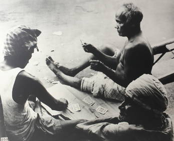
John Swope (American 1908-1979) Large format Silver Gelatin photograph CeylonGlobal Auctions Company4.3(36)See Sold PriceMar 03, 2024
BIRGER SANDZEN (1871-1954) PENCIL SIGNED BLOCK PRINTSoulis Auctions4.8(953)See Sold PriceFeb 24, 2024
SCARCE LARGE 'CLEOPATRA' PRINT AFTER MAXFIELD PARRISHSoulis Auctions4.8(953)See Sold PriceFeb 24, 2024
LARGE MECHANICAL PRINT 'STARS' AFTER MAXFIELD PARRISHSoulis Auctions4.8(953)See Sold PriceFeb 24, 2024
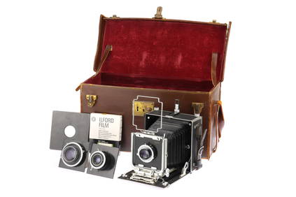
An Micro Precision Micro Technical VI Large Format Folding Bed Camera,Flints Auctions Ltd4.4(71)See Sold PriceFeb 29, 2024
Robert de Vaugondy - Map of Canada - Mer de l' Ouest or Sea of the West and a Northwest PassageProverde Auctions4.3(3)See Sold PriceFeb 28, 2024
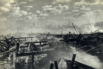
HENRI CARTIER BRESSON, 1947 NEW YORK CITY MANHATTAN FIRE AFTERMATHWhite Knight Auction, Inc4.7(252)See Sold PriceMar 03, 2024
Henri Cartier Bresson, 1947 New York City Manhattan Fire AftermathWhite Knight Auction, Inc4.7(252)See Sold PriceFeb 29, 2024