ATLAS of ANTIENT GEOGRAPHY by SAMUEL BUTLER 1843John McInnis Auctioneers,LLC4.6(502)See Sold PriceFeb 24, 2024
18TH C. ANTIQUE MAP: FRENCH & INDIAN WAR, FRAMEDThomaston Place Auction Galleries4.4(386)See Sold PriceFeb 24, 2024
Rand McNally Railroad Map Cabinet w/ 21 Railroad MapsRail & Road Auctions4.6(165)See Sold PriceMar 08, 2024
Keith Haring - Ink on New York Map, Best Buddies, Inscribed, Signed, and DatedSapphire Auction Gallery4(67)See Sold PriceMar 02, 2024
LATE 17TH C. FRENCH MAP OF THE NEW WORLD BY ALEXIS-HUBERT JAILLOT (1632-1712)Thomaston Place Auction Galleries4.4(386)See Sold PriceFeb 24, 2024
Central Railroad of New Jersey Map of Sandy Hook Route-ca. 1903JM Hobby Supply and Railroad Artifact Auctions4.4(126)See Sold PriceFeb 24, 2024
Lot of Six Mixed Atlas Box Cars-HO Scale-New in BoxJM Hobby Supply and Railroad Artifact Auctions4.4(126)See Sold PriceFeb 25, 2024
Rand McNally/Santa Fe Railroad Map of Iowa-1912JM Hobby Supply and Railroad Artifact Auctions4.4(126)See Sold PriceFeb 24, 2024
NICOLAES VISSCHER (NETHERLANDS, 1618-1709) MAP OF THE NEW WORLDThomaston Place Auction Galleries4.4(386)See Sold PriceFeb 24, 2024
17TH C. WORLD MAP BY NICOLAES VISSCHER (NETHERLANDS, 1618-1709)Thomaston Place Auction Galleries4.4(386)See Sold PriceFeb 24, 2024
Lot of Six Mixed Atlas Cabooses-HO Scale-New in BoxJM Hobby Supply and Railroad Artifact Auctions4.4(126)See Sold PriceFeb 25, 2024
La Principauté de Liege et le Duché de Limbourg. Belgium NL. VAUGONDY 1754 mapTITLE OF MAP (NOT PRINTED ON THE PAGE):'La Principauté de Liége et le Duché de Limbourg. Par le Sr. Robert de Vaugondy Géographe ordinaire du Roy. Avec Privilege' DATE PRINTED: 175See Sold Price
La Principauté de Liege et le Duché de Limbourg. NL Belgium. VAUGONDY 1754 mapTITLE OF MAP (NOT PRINTED ON THE PAGE):'La Principauté de Liége et le Duché de Limbourg. Par le Sr. Robert de Vaugondy Géographe ordinaire du Roy. Avec Privilege' DATE PRINTED: 175See Sold Price
La Principaute De Liege Et Le Duche De Limbourg ...Title/Content of Map: La Principaute De Liege Et Le Duche De Limbourg ... 1754" Date: 1757 Cartographer: ROBERT DE VAUGONDY, GILLES (1686-1766) Publisher: LES AUTEURS ET BOUDET Size: 1875Height - 18WiSee Sold Price
Partie Meridion. du Duché de Brabant. South Brabant Belgium. VAUGONDY 1752 mapTITLE OF MAP (NOT PRINTED ON THE PAGE):'Partie Meridion. du Duché de Brabant où se trouvent le Quartier de Bruxelles et de Louvain, la Seigneurie de Malines; et une partie de l'Eveché dSee Sold Price
Partie Meridion. du Duché de Brabant. Belgium South Brabant. VAUGONDY 1752 mapTITLE OF MAP (NOT PRINTED ON THE PAGE):'Partie Meridion. du Duché de Brabant où se trouvent le Quartier de Bruxelles et de Louvain, la Seigneurie de Malines; et une partie de l'Eveché dSee Sold Price
Gouvernement Général de Provence. Alpes Côte d'Azur. France. VAUGONDY 1754 mapTITLE OF MAP (NOT PRINTED ON THE PAGE):'Gouvernement Général de Provence, divise en ses Vigueries, avec les pays circonvoisins, le Comtat Vénaissin, la Principauté d'Orange, et lesSee Sold Price
1760 Maire/Leclerk Map of Eastern Belgium and Liege -- Carte De La Principaute De Liege Et De SesTitle: 1760 Maire/Leclerk Map of Eastern Belgium and Liege -- Carte De La Principaute De Liege Et De Ses Environs … Cartographer: C Maire/N Leclerk Year / Place: 1760 c., Liege Map Dimension (inSee Sold Price
1760 Maire/Leclerk Map of Eastern Belgium and Liege -- Carte De La Principaute De Liege Et De SesTitle: 1760 Maire/Leclerk Map of Eastern Belgium and Liege -- Carte De La Principaute De Liege Et De Ses Environs … Cartographer: C Maire/N Leclerk Year / Place: 1760 c., Liege Map Dimension (inSee Sold Price
1760 Maire/Leclerk Map of Eastern Belgium and Liege --Title: 1760 Maire/Leclerk Map of Eastern Belgium and Liege -- Carte De La Principaute De Liege Et De Ses Environs … Cartographer: C Maire/N Leclerk Year / Place: 1760 c., Liege Map Dimension (in.):See Sold Price
Carte du Duche de Luxembourg. Duchy of Luxemburg. S Belgium. VAUGONDY 1753 mapTITLE OF MAP (NOT PRINTED ON THE PAGE):'Carte du Duche de Luxembourg, dans laquelle on trouve la partie Meridionale & limitrophe de la Seigneurie de Lyege. Par le Sr. Robert de Vaugondy GéographeSee Sold Price
SoldLow Countries.- Nicolas Le Clerc (R.P.) Carte De LaLow Countries.- Nicolas Le Clerc (R.P.) Carte De La Principaute De Liege Et De Ses Environs..., large and detailed map of Liege and its environs, augmented to include Brabant and Breda by Everard KintSee Sold Price
Low Countries.- Nicolas Le Clerc (R.P.) Carte De LaLow Countries.- Nicolas Le Clerc (R.P.) Carte De La Principaute De Liege Et De Ses Environs..., large and detailed map of Liege and its environs, augmented to include Brabant and Breda by Everard KintSee Sold Price
Comtés de Hainaut, et de Cambrésis. Belgium/France. Cambrai. VAUGONDY 1754 mapTITLE OF MAP (NOT PRINTED ON THE PAGE):'Comtés de Hainaut, et de Cambrésis, avec les confins du Comté de Flandre, du Duché de Brabant, du Comté de Namur, et une partie de la SSee Sold Price
Comtés de Hainaut, et de Cambrésis. Cambrai. Belgium/France. VAUGONDY 1754 mapTITLE OF MAP (NOT PRINTED ON THE PAGE):'Comtés de Hainaut, et de Cambrésis, avec les confins du Comté de Flandre, du Duché de Brabant, du Comté de Namur, et une partie de la SSee Sold Price
Etats de la Couronne d'Aragon… Catalonia Catalunya. NE Spain VAUGONDY 1752 mapTITLE OF MAP (NOT PRINTED ON THE PAGE):'Etats de la Couronne d'Aragon, ou se trouvent les Royaumes d'Aragon et de Navarre, la Principauté de Catalogne. Par le Sr. Robert de Vaugondy fils GeographSee Sold Price
Partie Méridionale du Cercle d'Autriche. Southern Austria. VAUGONDY 1752 mapTITLE OF MAP (NOT PRINTED ON THE PAGE):'Partie Méridionale du Cercle d'Autriche, qui comprend la basse partie du Duché de Stirie, le Duché de Carinthie, divisé en haute et basse; lSee Sold Price
Partie Méridionale du Cercle d'Autriche. Slovenia Austria. VAUGONDY 1752 mapTITLE OF MAP (NOT PRINTED ON THE PAGE):'Partie Méridionale du Cercle d'Autriche, qui comprend la basse partie du Duché de Stirie, le Duché de Carinthie, divisé en haute et basse; lSee Sold Price
Duché de Savoye… Duchy of Savoie. Aosta & French Alps. VAUGONDY 1751 old mapTITLE OF MAP (NOT PRINTED ON THE PAGE):'Duché de Savoye qui comprend le Chablais, le Fossigny, le Génevois, la Savoye Propre, la Tarentaise et la Maurienne; dressé d'après la GrandSee Sold Price
Duché de Savoye… Duchy of Savoie. French Alps. Aosta. VAUGONDY 1751 old mapTITLE OF MAP (NOT PRINTED ON THE PAGE):'Duché de Savoye qui comprend le Chablais, le Fossigny, le Génevois, la Savoye Propre, la Tarentaise et la Maurienne; dressé d'après la GrandSee Sold Price
Soldde la Tour: Antique Map of Poland Lithuania, 1771TITLE/CONTENT OF MAP: 'Etats de Pologne et de Lithuanie, divisés par Palatinats et Provinces Ecclesiastiques. Avec le Roiaume de Prusse et le Duché de Curlande. D'après d'exactes connaissances acquSee Sold Price
Le Royaume d'Angleterre divisé selon les 7 royaumes… England VAUGONDY 1753 mapTITLE OF MAP (NOT PRINTED ON THE PAGE):'Le Royaume d'Angleterre, divisé selon les sept Royaumes, ou Heptarchie des Saxons, avec la Principauté de Galles; et subdivise en Shires ou ComtéSee Sold Price
SoldVaugondy: Map of La Judée, 1785Map of La Judée depuis le retour de la captivité ... N. S. Jesus-Christ. Sr. Robert de Vaugondy. Size with Margin 47 x 42 cm. 1785. Please note that this lot has a confidential reserve. When you leSee Sold Price
SoldMAP OF VA & MD, after Peter Fry & Peter JeffersonMAP OF VA & MD, after Peter Fry & Peter Jefferson; Carte de la Virginie et du Maryland. [Paris]: 1755. Hand-colored double-page engraved map Robert de Vaugondy's important reduction of Fry and JeffersSee Sold Price
Robert de Vaugondy: Map of Judea, the Holy Land, 1657Carte de la Terre de Canaan ou Terre Promise a Abraham et la Posterite dans Laquelle on a Trace la fortie du people…. By: Robert de Vaugondy Date: 1657 (circa) Paris Dimensions: 18.75 x 23 inches (4See Sold Price
LARGE LATE 17TH C. DUTCH CHART OF CANADA, GREAT LAKES, NEW FRANCE, LABRADOR, HUDSON BAY, BY PIERREThomaston Place Auction Galleries4.4(386)See Sold PriceFeb 24, 2024
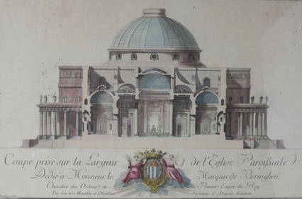
Charles Dupuis French 18th century, Pair Hand Colored Engravings, ArchitecturalGlobal Auctions Company4.3(36)See Sold PriceMar 03, 2024
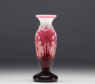
CHARDER, Charles SCHNEIDER (1881-1953) - French glass - Vase with floral decoration.GOLDFIELD AUCTION4.3(32)See Sold PriceMar 02, 2024
Luc LANEL (1893-1965) pour CHRISTOFLE. Ménagère en métal argenté modèle Atlas comprenant douzeValoir Pousse-Cornet4.3(4)See Sold PriceFeb 24, 2024
Pierre CHAREAU (1883-1950) Enfilade moderniste variante du modèle MA 788 à caisson cubiqueValoir Pousse-Cornet4.3(4)See Sold PriceFeb 24, 2024
André CAZENAVE (1928-2003) pour Atelier A: Réunion de trois lampes caillou en fibre de verre etValoir Pousse-Cornet4.3(4)See Sold PriceFeb 24, 2024
LOUIS XIV (1643-1715, roi de France 1651-1715) – 1702IEGOR Auctions4.2(133)See Sold PriceFeb 28, 2024
Map of St. Kitts and Nevis Depot de la Marine, Paris, 1758Global Auctions Company4.3(36)See Sold PriceMar 03, 2024
D'Entrecasteaux - Australia: Chart of Van Diemen's Land (New Holland). 3Trillium Antique Prints & Rare Books4.5(30)See Sold PriceFeb 24, 2024
Vaillant - Kealakekua Bay, Hawaii (Village de Kearakekoua, Iles Sandwich). 44Trillium Antique Prints & Rare Books4.5(30)See Sold PriceFeb 24, 2024
Vaillant - Honolulu, Hawaii (Vue de Honolulu, Iles Sandwich). 45Trillium Antique Prints & Rare Books4.5(30)See Sold PriceFeb 24, 2024
Vaillant - Hawaiian Dance (Scene de Danse aux Iles Sandwich). 42Trillium Antique Prints & Rare Books4.5(30)See Sold PriceFeb 24, 2024
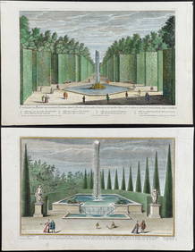
Demortain - 4 Fountain & Garden EngravingsTrillium Antique Prints & Rare Books4.5(30)See Sold PriceFeb 24, 2024
First Copy of Gautier's Le Roman de la Momie - 13 Original Watercolors by George Barbier (2 VolumesTrillium Antique Prints & Rare Books4.5(30)See Sold PriceFeb 24, 2024
1764 Bellin Map of Antigua -- Carte de l'Isle d'Antigue Situee par la Latitude 17 Degres et par laJasper524.5(9.8k)See Sold PriceFeb 27, 2024
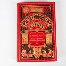
Jules Verne, Le Village Aerien, A Un Elephant & A L'EventailLion and Unicorn4.7(1.8k)See Sold PriceMar 10, 2024