La Perouse Chart of NW Coast on 3 sheets 1798Title: Chart of the North West Coast of America. Explored by the Boussole and Astrolabe in 1786 Author: La Pérouse, Jean François Galaup de Description: Copper-engraved chart on 3 sheets. Each sheetSee Sold Price
Sold1798 Antique Maps La Perouse Views NW Coast (3)Circa 1798 Antique Maps, set of three with Views of the North West Coast of America. G. G. and J. Robinson, Paternoster Row, London. La Perouse. Measure 11 in. x 17 in. On rag paper. Unframed, loose aSee Sold Price
Carte Particuliere de la Côte du Nord-Ouest de l'Author: La Pérouse, Jean François Galaup de Two copper-engraved charts. Each approx. 49x68 cm. (19½x26¾"). The first and second sheets of La Perouse's important chart of the west coast and archipeSee Sold Price
SoldCa.1798 La Perouse China Seas Chart of DiscoveriesCa.1798 La Perouse Sheet I and II Chart of Discoveries in the Seas of China and Tartary. Published by G. G. and J. Robinson, Paternoster Row, London. Tape across center on verso. Measure 17 in. x 22 iSee Sold Price
SoldLa Perouse. Côte du Nord-Ouest de l'AmériqueLa Perouse (Jean Francois Galoup de) Carte Particuliere de la Côte du Nord-Ouest de l'Amérique,North-west coast of America from Alaska to California, on 3 sheets, the first extending from MounSee Sold Price
SoldChart of Pacific Coast on 3 sheets 1850Heading: Author: United States Coast Survey Title: Reconnoissance of the Western Coast of the United States from Monterey to the Columbia River in three sheets... By the Hydrographic Party under theSee Sold Price
SoldChart of Pacific Coast on 3 sheets 1851Heading: Author: United States Coast Survey Title: Reconnoissance of the Western Coast of the United States from Monterey to the Columbia River in three sheets... By the Hydrographic Party under theSee Sold Price
Chart of Pacific Coast on 3 sheets 1851Heading: Author: U.S. Coast Survey A.D. Bache Superintendent Title: Reconnoissance of the Western Coast of the United States from Monterey to the Columbia River in three sheets... By the HydrographicSee Sold Price
Chart of Pacific Coast on 3 sheets 1850Heading: Author: U.S. Coast Survey A.D. Bache Superintendent Title: Reconnoissance of the Western Coast of the United States from Monterey to the Columbia River in three sheets... By the HydrographicSee Sold Price
Carte Particuliere de la Côte du Nord-Ouest de l'Author: La Pérouse, Jean François Galaup de Description: Two copper-engraved charts. Each approx. 49x68 cm. (19½x26¾"). The first and second sheets of La Perouse's important chart of the west coasSee Sold Price
JEAN-FRANCOIS DE GALAUP LA PEROUSE - CHART OF THE GREATJean-francois De Galaup La Perouse - Chart Of The Great Pacific Ocean, 1799 - 30 X 21 3/4 In. - This Giclée Print Is Gallery Stretched And Ready To Hang Or Lean Against A Wall, Or Display On An EaselSee Sold Price
Sold5 Pacific island maps[Pacific Islands]. 5 engraved maps. ++ [La Perouse]. Chart Of Necker Island [Hawaii]. Neale engraver. Lon: G.G & J. Robinson, 1798. 14 1/2 x 17 7/8 in. on thin paper. Folds, short tear in margin. InseSee Sold Price
SoldA Voyage Round the World La Pérouse 3 vol. 1798Heading: Author: La Pérouse, Jean-François de Galaup Title: A Voyage Round the World, in the Years 1785, 1786, 1787, and 1788 Place Published: London Publisher:Printed for J Johnson Date PublisSee Sold Price
SoldCa.1798 La Perouse Maps and Charts (6)Circa 1798 six La Perouse maps and charts published by G. G. and J. Robinson, Paternoster Row, London. All taped across center on verso. Measure approximately 22 in. x 17.25 in. portrait and 17.25 in.See Sold Price
MAP - Southeastern Alaska. La PerouseSoutheastern Alaska. Jean Francois Galoup, Comte La Perouse, Plan of the Entrance of the Port of Bucarelli on the North West Coast of America..., 1798 (dated). Black & White. This large-scale chart coSee Sold Price
SoldCharts of Northwest Coast and Alaska 1797Title: Carte Particuliere de la Côte du Nord-Ouest de l'Amérique reconnue par les Frégates Françaises La Boussole et l'Astrolabe en 1786. 1e. [& 2e.] Feuille Author: La Pérouse, Jean François GaSee Sold Price
Charts of Northwest Coast and Alaska 1797Title: Carte Particuliere de la Côte du Nord-Ouest de l'Amérique reconnue par les Frégates Françaises La Boussole et l'Astrolabe en 1786. 1e. [& 2e.] Feuille Author: La Pérouse, Jean François GaSee Sold Price
Bay of Bengal - East Coast, sheet 3 Koronge Island toTitle/Content of Map: Bay of Bengal - East Coast, sheet 3 Koronge Island to White Point British Admiralty Chart 823, published in 1873 Date Printed: 1873 Cartographer: British Admiralty Material/MediuSee Sold Price
Two charts of the West Coast 1797Heading: Author: La Pérouse, Jean Francois Galaup de Title: Two charts of the Pacific Northwest coast from the atlas of the account of the voyages of La Pérouse Place Published: Paris Publisher:See Sold Price
Pacific Charts by La PérouseTitle: Three charts on two sheets, from the Atlas to La Pérouse's Voyage Author: La Pérouse, Jean François Galaup de Description: Includes: Carte d'une Partie du Grande Océan à l'E. et SE. de laSee Sold Price
LA PEROUSE. Lot of 9 maps, sold togetherLA PEROUSE. Lot of 9 maps sold together. Engraved maps hand coloured in outline. Each approx. 38 x 49 cm.VUES DE LA COTE DU NORD-OUEST DE L'AMERIQUE. ** CHART OF THE NORTHWEST COAST OF AMERICA. ** PLASee Sold Price
French Chart of San Diego 1798Heading: Author: La Perouse, Jean François Galaup de. Title: Plan of the Port of S. Diego en California situatr in 32o 39" 0' of Latitude North & 12o 4' 0" West of St. Blas from a Survey in 1782 PlaSee Sold Price
SoldFrench Chart of San Diego 1798Heading: Author: La Perouse, Jean François Galaup de Title: Plan of the Port of S. Diego en California situatr in 32° 39' 0" of Latitude North & 12° 4' 0" West of St. Blas from a Survey in 1782 PlSee Sold Price
SoldDépôt de la Marine. 3 Newfoundland chartsDépôt de la Marine. Publishers.- Plan du Havre de Petit Port; Plan de L'ile et du mouillage de Cod-Roy; Plan du Havre de Lark, 3 charts of the Newfoundland coast, 3 engraved charts, each c.530See Sold Price
LATE 18TH C. VERY LARGE CHART OF NORTHEAST CANADA BY DES BARRES (1721-1824), 1780, FRAMEDThomaston Place Auction Galleries4.4(386)See Sold PriceFeb 24, 2024
LARGE LATE 17TH C. DUTCH CHART OF CANADA, GREAT LAKES, NEW FRANCE, LABRADOR, HUDSON BAY, BY PIERREThomaston Place Auction Galleries4.4(386)See Sold PriceFeb 24, 2024
Haida Ghuut Eagle Copper NW Coast Tribal Art by Bill Reid (1920-1998)Cowboy Joe's Antiques4.7(189)See Sold PriceFeb 27, 2024
Haida Ghuut Copper Frog NW Coast Tribal Art by Bill Reid (1920-1998)Cowboy Joe's Antiques4.7(189)See Sold PriceFeb 27, 2024
after Salvator Rosa 1615-1673 Engraving La Pythonisse d'Endor ChasselatGlobal Auctions Company4.3(36)See Sold PriceMar 03, 2024
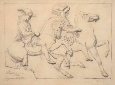
Georges Seurat (French, 1859-1891) - Parthénon (Fragment de la Frise)Freeman's | Hindman4.5(158)See Sold PriceFeb 27, 2024
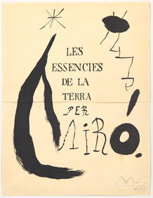
Joan Miró (Spanish, 1893-1983) - Projet pour la Page de Titre de l’Album 'Les EssenciesFreeman's | Hindman4.5(158)See Sold PriceFeb 27, 2024
James Ensor (Belgian, 1860-1949) - Le Luminisme, Le Futurisme, La Gravure à L'Eau-Forte (LaFreeman's | Hindman4.5(158)See Sold PriceFeb 27, 2024
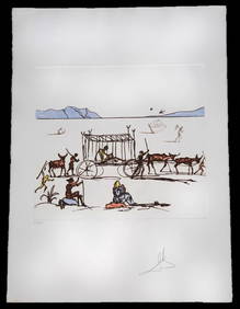
Salvador Dali "Judgement" Color Etching & AquatintNapoleon's Fine Art4.4(75)See Sold PriceFeb 25, 2024
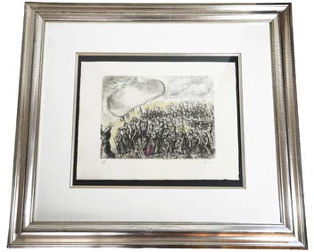
[ENSLAVEMENT & ABOLITION]. A group of 3 prints related to the Atlantic slave trade, including plansFreeman's | Hindman4.4(1.6k)See Sold PriceFeb 27, 2024
[CIVIL WAR]. Letter from Captain Henry R. Sibley in which he expresses his pro-EmancipationFreeman's | Hindman4.4(1.6k)See Sold PriceFeb 27, 2024
D'Entrecasteaux - Australia: Chart of Van Diemen's Land (New Holland). 3Trillium Antique Prints & Rare Books4.5(30)See Sold PriceFeb 24, 2024
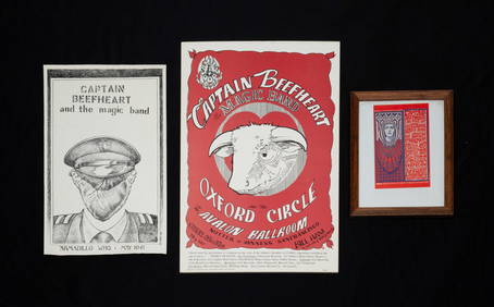
CAPTAIN BEEFHEART TWO POSTERS AND POSTCARD.Amelia Jeffers, Auctioneers & Appraisers4.6(101)See Sold PriceMar 09, 2024


![[ENSLAVEMENT & ABOLITION]. A group of 3 prints related to the Atlantic slave trade, including plans (1 of 3)](https://p1.liveauctioneers.com/197/319238/171468007_1_x.jpg?height=282&quality=70&version=1707520367)
![[CIVIL WAR]. Letter from Captain Henry R. Sibley in which he expresses his pro-Emancipation (1 of 2)](https://p1.liveauctioneers.com/197/319238/171468116_1_x.jpg?height=282&quality=70&version=1707520367)