SoldKS, NE, CO, WY, DK, Montana 1874 Hand Colored MapThis is a hand colored 1872 map titled, "County Map of Kansas, Nebraska, Colorado, Wyoming, Dakota, Montana." The map is marked across the bottom, "Entered according to Act of Congress in the year 187See Sold Price
SoldBAKER, Samuel W., Sir (1821-1893). Ismailïa. London:BAKER, Samuel W., Sir (1821-1893). Ismailïa. London: Macmillan and Co., 1874. 2 volumes, 4to (220 x 144 mm). 2 hand-colored maps (1 folding, torn from stub); numerous plates including frontispieces.See Sold Price
Sold1874 ATLAS OF SENECA CO. NY BY POMEROY, MAPS.1874 ATLAS OF SENECA CO. NY BY POMEROY, MAPS. 45 PGS HAND COLORED MAPS INCL. BUSIN. DIRECTORIES, EXPLANATIONS, POPULATION, POST OFFICES, ETC. PUBLISHED BY POMEROY, WHITMAN & CO, PHIL. 1874. ORIG. HARDSee Sold Price
Sold1874 ATLAS OF WAYNE CO. NY MAPS BY BEERS.1874 ATLAS OF WAYNE CO. NY MAPS BY BEERS. 87 PGS OF HAND COLORED MAPS INCL. BUSIN. DIRECTORY, DISTANCE TABLE, POST OFFICES, POPULATION, ETC. PUBLISHED BY D. G. BEERS & CO, PHIL. 1874. NEW GREEN CLOTHSee Sold Price
COLTON, G.W. and C.B. Colton's New railroad Map of theCOLTON, G.W. and C.B. Colton's New railroad Map of the States of OH, MI, IN, IL, MO, WI & IA. MN, NE & KS. New York, 1870. Engraved folding map hand-colored in wash and outline, sheet 21 6/8 x 29 1/8See Sold Price
Sold1874 ATLAS OF ONTARIO CO. NY MAPS.1874 OF ATLAS ONTARIO CO. NY MAPS. 83 PGS HAND COLORED MAPS. INCLUDES STATE MAP, OUTLINE PLAN, DISTANCE TABLE, POST OFFICES, POPULATIONS, EXPLANATIONS. PUBLISHED BY POMEROY, WHITMAN & CO. PHILADELPHIASee Sold Price
Sold1874 OF ATLAS ONTARIO CO. NY MAPS.1874 OF ATLAS ONTARIO CO. NY MAPS. 83 PGS HAND COLORED MAPS. INCLUDES STATE MAP, OUTLINE PLAN, DISTANCE TABLE, POST OFFICES, POPULATIONS, EXPLANATIONS. PUBLISHED BY POMEROY, WHITMAN & CO. PHILADELPHIASee Sold Price
SoldMap of Oregon, Washington, Idaho, & Montana 1867 TThis is an 1867 hand colored map titled, "Map of Oregon, Washington, Idaho, and part of Montana." "Entered according to Act of Congress in the year 1867 by S. Augustus Mitchell in the Clerks Office ofSee Sold Price
SoldMap of Oregon, Washington, Idaho, & Montana 1866 TThis is an 1866 hand colored map titled, "Map of Oregon, Washington, Idaho, and part of Montana." "Entered according to Act of Congress in the year 1866 by S. Augustus Mitchell Jr. in the Clerks OfficSee Sold Price
SoldMontana Idaho & Wyoming 1894 W.M. Bradley This isThis is an original rare map of Montana Idaho and Wyoming from 1894. The piece is from Wm. M. Bradley in 1894 showing a great condition. This is a hand colored map. The map is on a matte board protectSee Sold Price
Sold1874 Atlas of Cuyahoga County OhioThis is an 1874 atlas of Cuyahoga County, Ohio. The atlas was published by Titus, Simmons & Titus. The atlas features hand colored maps and lithographs throughout. The atlas shows good condition. It mSee Sold Price
SoldJohnson's Map of Montana & Surrounding States 1865This is a hand colored original 1865 map titled, "Johnson's Nebraska, Dakota, Idaho, Montana and Wyoming. Published by A.J. Johnson, New York." The bottom right of the map is marked, "Entered accordinSee Sold Price
SoldRand, McNally & Co. Hand-colored Lithographed Map ofOregon. Rand, McNally & Co. from Indexed Atlas of the World. Hand-colored Lithograph. Chicago: Rand, McNally & Co, c. 1884. 21 3/4 x 29 inches. Beautiful, hand-colored map from Rand, McNally & Co.’sSee Sold Price
SoldUnited States: 1882 Hand-Colored Map by G.W. & CUnited States: 1882 Hand-Colored Map by G.W. & C. Colton & Co., in Vintage Frame, See Sold Price
SoldHand-colored map of New York by David H. Burr, EnHand-colored map of New York by David H. Burr, Engd. By Rawdon, Clark & Co., Albany & Rawdon, Wright & Co., New York. 20”x25”See Sold Price
19thc Colton Hand-colored Map of Germany19th Century hand-colored atlas map of Germany, No. 1 Published by J. H. Colton & Co., with inset maps of Bremen & Hamburg. 13 1/2" X 16 1/2".See Sold Price
19thc Colton Hand-colored Map of Germany19th Century hand-colored atlas map of Germany, No. 1 Published by J. H. Colton & Co., with inset maps of Bremen & Hamburg. 13 1/2" X 16 1/2".See Sold Price
19thc Colton Hand-colored Map of Germany19th Century hand-colored atlas map of Germany, No. 1 Published by J. H. Colton & Co., with inset maps of Bremen & Hamburg. 13 1/2" X 16 1/2".See Sold Price
SoldHand-colored maps, A. Guyot's Geography(Lot of 4) Assorted hand-colored engraved maps, including: two ''Maps of the World,'' 1872, ''Winds of the World'' and ''Temperature of the Air,'' printed by Scribner Armstrong and Co., for A. Guyot'sSee Sold Price
SoldHand-Colored Atlas, 1848MITCHELL'S SCHOOL ATLAS. Philadelphia: Thomas, Cowperthwait & Co., 1848. 11.75" x 9". [8] pp. + 27 (of 28) hand-colored maps on 22 sheets (lacks map of Antarctic), including several small maps inset aSee Sold Price
Sold[Atlas] Commercial edition of Colton's Atlas 1856Colton, J.H. Colton's Atlas of America. New York J.H. Colton and Co., 1856. 19" x 15.5". Philadelphia Commercial Edition with large number of ads. 61 (of 63) hand-colored maps/plans, some bound out ofSee Sold Price
Sold1 piece. Hand-Colored Lithographic Map. G.W. & C.1 piece. Hand-Colored Lithographic Map. G.W. & C.B. Calton & Co. Map of the State of Florida. New York, 1882. Approx. 26 x 27 inches; 660 x 685 mm. Some creasing & occasional minor spotting & soiling.See Sold Price
SoldNine hand-colored engraved maps, 19th Century(Lot of 9) Unframed hand-colored engraved maps consisting of: ''Map of the World, Course of Tidal Waves,'' 1872, published by Scribner, Armstrong and Co., ''Map of the World,'' 1860, printed by CharleSee Sold Price
SoldHand-Colored Engraved Maps, 19th Century, Oceans(Lot of 6) Hand-colored 19th century engraved maps, including: ''Map of the World, Course of Tidal Waves,'' 1872, Published by Scribner, Armstrong and Co.; ''Grossen Ocean,'' ''Atlantic Ocean,'' and 'See Sold Price
LATE 17TH C. FRENCH MAP OF THE NEW WORLD BY ALEXIS-HUBERT JAILLOT (1632-1712)Thomaston Place Auction Galleries4.4(389)See Sold PriceFeb 24, 2024
18TH C. ANTIQUE MAP: FRENCH & INDIAN WAR, FRAMEDThomaston Place Auction Galleries4.4(389)See Sold PriceFeb 24, 2024
NICOLAES VISSCHER (NETHERLANDS, 1618-1709) MAP OF THE NEW WORLDThomaston Place Auction Galleries4.4(389)See Sold PriceFeb 24, 2024
Japanese Woodblock c1950 Valley Of Trees Hand Colored 10" x 7"Luis Porretta Fine Arts4.3(10)See Sold PriceMar 02, 2024
An early Dutch hand colored engraving map by Georg Balthasar Probst (1732-1801)Ostantix Auctions4.4(10)See Sold PriceFeb 27, 2024
[ARCTIC]. BOWEN, Emanuel. A New & Accurate Map of the North...Potter & Potter Auctions4.6(544)See Sold PriceMar 07, 2024
[LITHOGRAPHY]. [NATIVE AMERICANS]. Group of Five Hand-Color...Potter & Potter Auctions4.6(544)See Sold PriceMar 07, 2024
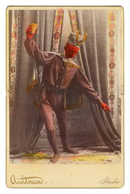
Hand-Colored Large Cabinet Card of the Devi...Potter & Potter Auctions4.6(544)See Sold PriceMar 07, 2024
[CHICAGO]. Rare Pre-Fire Illinois Map: “Blanchard’s Map of ...Potter & Potter Auctions4.6(544)See Sold PriceMar 07, 2024
[MAPS]. DUFOUR, Auguste-Henri (1795-1865). Bound Volume of ...Potter & Potter Auctions4.6(544)See Sold PriceMar 07, 2024
Fifth Avenue New York Antique Hatch & Co.hand colored "Row of Dwelling Houses"Collective Hudson4.5(56)See Sold PriceMar 01, 2024
Johann Homann Hand-Colored Map Engraving, c. 1730Auctions at Showplace4.6(731)See Sold PriceMar 17, 2024
Willem Blaeu, Etc. 17th C. Antiquarian Maps, 2Auctions at Showplace4.6(731)See Sold PriceMar 17, 2024
D'Oyly (Calcutta, India) - Procession of the CurruckpoojaTrillium Antique Prints & Rare Books4.5(30)See Sold PriceFeb 24, 2024
Audubon - Common Osprey Fish Hawk. 15Trillium Antique Prints & Rare Books4.5(30)See Sold PriceFeb 24, 2024
Donovan - Mermaid, Merman, & Rufous Orang Outang (Orangutan). 59Trillium Antique Prints & Rare Books4.5(30)See Sold PriceFeb 24, 2024
Wilson - Carolina Parrot & Flycatchers. 26Trillium Antique Prints & Rare Books4.5(30)See Sold PriceFeb 24, 2024
Catesby, Folio - Red Bellied Woodpecker & Hairy Woodpecker with Black Oak. 1-19Trillium Antique Prints & Rare Books4.5(30)See Sold PriceFeb 24, 2024


![[Atlas] Commercial edition of Colton's Atlas 1856 (1 of 9)](https://p1.liveauctioneers.com/3532/79779/41533465_1_x.jpg?height=282&quality=70&version=1444167022)


![[ARCTIC]. BOWEN, Emanuel. A New & Accurate Map of the North... (1 of 1)](https://p1.liveauctioneers.com/928/318880/171360917_1_x.jpg?height=282&quality=70&version=1707501302)
![[LITHOGRAPHY]. [NATIVE AMERICANS]. Group of Five Hand-Color... (1 of 5)](https://p1.liveauctioneers.com/928/318880/171361074_1_x.jpg?height=282&quality=70&version=1707501302)
![[CHICAGO]. Rare Pre-Fire Illinois Map: “Blanchard’s Map of ... (1 of 2)](https://p1.liveauctioneers.com/928/318880/171361260_1_x.jpg?height=282&quality=70&version=1707501302)
![[MAPS]. DUFOUR, Auguste-Henri (1795-1865). Bound Volume of ... (1 of 2)](https://p1.liveauctioneers.com/928/318880/171361279_1_x.jpg?height=282&quality=70&version=1707501302)