ATLAS of ANTIENT GEOGRAPHY by SAMUEL BUTLER 1843John McInnis Auctioneers,LLC4.6(502)See Sold PriceFeb 24, 2024
18TH C. ANTIQUE MAP: FRENCH & INDIAN WAR, FRAMEDThomaston Place Auction Galleries4.4(386)See Sold PriceFeb 24, 2024
Rand McNally Railroad Map Cabinet w/ 21 Railroad MapsRail & Road Auctions4.6(165)See Sold PriceMar 08, 2024
Keith Haring - Ink on New York Map, Best Buddies, Inscribed, Signed, and DatedSapphire Auction Gallery4(67)See Sold PriceMar 02, 2024
LATE 17TH C. FRENCH MAP OF THE NEW WORLD BY ALEXIS-HUBERT JAILLOT (1632-1712)Thomaston Place Auction Galleries4.4(386)See Sold PriceFeb 24, 2024
Central Railroad of New Jersey Map of Sandy Hook Route-ca. 1903JM Hobby Supply and Railroad Artifact Auctions4.4(126)See Sold PriceFeb 24, 2024
Lot of Six Mixed Atlas Box Cars-HO Scale-New in BoxJM Hobby Supply and Railroad Artifact Auctions4.4(126)See Sold PriceFeb 25, 2024
Rand McNally/Santa Fe Railroad Map of Iowa-1912JM Hobby Supply and Railroad Artifact Auctions4.4(126)See Sold PriceFeb 24, 2024
NICOLAES VISSCHER (NETHERLANDS, 1618-1709) MAP OF THE NEW WORLDThomaston Place Auction Galleries4.4(386)See Sold PriceFeb 24, 2024
17TH C. WORLD MAP BY NICOLAES VISSCHER (NETHERLANDS, 1618-1709)Thomaston Place Auction Galleries4.4(386)See Sold PriceFeb 24, 2024
Lot of Six Mixed Atlas Cabooses-HO Scale-New in BoxJM Hobby Supply and Railroad Artifact Auctions4.4(126)See Sold PriceFeb 25, 2024
Johnson's France Spain and PortugalTitle/Content of Map: Johnson's France Spain and Portugal Date: 1865 Cartographer: JOHNSON, ALVIN JEWETT Size: 23.25x17 Scarce new Johnson regional map showing all of southwestern Europe. WaterstainedSee Sold Price
Johnson's France Spain and PortugalPublication Date: 1865 Title: Johnson's France Spain and Portugal Cartographer: JOHNSON, ALVIN JEWETT Publisher: JOHNSON AND WARD Height: 23.25 Width: 17 Scarce new Johnson regional map showing all ofSee Sold Price
Johnson's France, Spain and Portugal. Corsica Gibraltar Iberia 1865 old mapTITLE/CONTENT OF MAP: 'Johnson's France, Spain, and Portugal // Corsica - Gibraltar Rock' DATE PRINTED: 1865 IMAGE SIZE: Approx 60.0 x 45.5cm, 23.75 x 17.75 inches (Large); Please note that this is aSee Sold Price
ANCIENT ROMAN BALKANS. Illyricum Dacia Moesia Macedonia. ARROWSMITH 1828 mapTITLE/CONTENT OF MAP: 'Johnson's France, Spain, and Portugal // Corsica - Gibraltar Rock' DATE PRINTED: 1865 IMAGE SIZE: Approx 60.0 x 45.5cm, 23.75 x 17.75 inches (Large); Please note that this is aSee Sold Price
Johnson's Map of France, Spain & Portugal, 1864Original engraving Map of France, Spain & Portugal from World Atlas by Johnson, New York, 1864. Map includes significant vignettes of Corsica and Gibraltar. Displayed in a wood frame and UV protectantSee Sold Price
SoldA.J. Johnson Map of France, Spain, and PortugalWith inset map of Gibraltar Rock. 23" X 17" (31.5" X 25")See Sold Price
1865 Johnson's Map of France, Spain, and Portugal, Johnson & Ward NY19th century. A hand-colored United States published map of France, Spain, and Portugal. Published by Johnson and Ward, New York USA. Marked as page 80/81. Overall good condition; some toning throughSee Sold Price
A.J. Johnson Map of France, Spain, and PortugalWith inset map of Gibraltar Rock. 23" X 17" (31.5" X 25")See Sold Price
SoldALVIN JEWETT JOHNSON, (American, 1827-1884), France,ALVIN JEWETT JOHNSON (American, 1827-1884) France, Spain and Portugal, 1865 Hand colored engraving Includes the Balearic Islands of Majorca, Minorca and Ibiza. Lower right hand quadrant features insetSee Sold Price
SoldA.J. Johnson antique maps(lot of 2) Unframed antique maps by A.J. Johnson "England and Wales" (circa 1865) image: approx. 26.75"H x 18"W and "France, Spain & Portugal" (circa 1864), image: approx. 26.75"H x 18"WSee Sold Price
Map of Empire of France, Spain & Portugal, 1868Original engraving from Johnson's Atlas of the World, 1868. Map includes vignette of Malta and details cities, towns and territories. Dimensions: 18" x 26". No Reserve This item ships from Ocean View,See Sold Price
Map of Empire of France, Spain & Portugal, 1868Original engraving from Johnson's Atlas of the World, 1868. Map includes vignette of Malta and details cities, towns and territories. Dimensions: 18" x 26". This item ships from Ocean View, DE.See Sold Price
SoldFrance, Spain & Portugal. Inserts of Corsica and rockFrance, Spain & Portugal. Inserts of Corsica and rock of Gibraltar 1868 A.J. Johnson 18" x 26 1/3" Hand colored engraved Map. Published in New York in Johnson's New Illustrated Family Atlas of the WorSee Sold Price
Map of Empire of France, Spain & Portugal, 1868Original engraving from Johnson's Atlas of the World, 1868. Map includes vignette of Malta and details cities, towns and territories. Dimensions: 18" x 26". No Reserve Buyer pays shipping - ships fromSee Sold Price
SoldJohnson and Ward, New York, Hand-Colored MapsTwo Johnson and Ward, New York, Hand-Colored Engraved Maps, one of France, Spain and Portugal, 1863, the other a Johnson and Ward similarly colored engraved map of England and Wales, also third quarteSee Sold Price
SoldJohnson and Ward, New York, Hand-Colored MapsTwo Johnson and Ward, New York, Hand-Colored Engraved Maps, one of France, Spain and Portugal, 1863, the other a Johnson and Ward similarly colored engraved map of England and Wales, also third quarteSee Sold Price
SoldMitchell: Map of France Spain Portugal Helvetia 18621862 Mitchell Map of France, Spain, Portugal and Helvetia. An attractive map of Southwestern Europe. Switzerland and Corsica are shown in inserts. Lots of topographical details along with towns and ciSee Sold Price
SoldMitchell: Map of France, Spain, & Portugal, 1864Title: Map of France, Spain, and Portugal by Mitchell Date: 1864 Dimensions (inches): 14 x 17 Medium: Hand Colored Lithograph Condition: Good Condition Please note that this lot has a confidential rSee Sold Price
Mitchell: Antique Map of France Spain Portugal, 1869Title/Content of Map: France, Spain, Portugal with insert of Switzerland Date Printed: 1869 Cartographer: Augustus S. Mitchell Material/Medium: Paper Size: 12" x 15" Hand colored engraved Map. From hiSee Sold Price
Sold1862 Mitchell Map of France, Spain, Portugal andTitle/Content of Map: 1862 Mitchell Map of France, Spain, Portugal and Helvetia -- Map of France, Spain and Portugal Cartographer: S Mitchell Size: 13.5 X 11 in. An attractive map of Southwestern EuroSee Sold Price
Mitchell: Antique Map of France, Spain, Portugal, 1862Title/Content of Map: Map of France, Spain, and Portugal. | Switzerland In Cantons | Island of Corsica. Date Printed: 1862 ca. Cartographer: MITCHELL, SAMUEL AUGUSTUS (JR.) Size: Quarto – 10.75 H xSee Sold Price
Mitchell: Antique Map of France, Spain, Portugal 1862Title/Content of Map: 1862 Mitchell Map of France, Spain, Portugal and Helvetia -- Map of France, Spain and Portugal Date Printed: 1862, Philadelphia Cartographer: S Mitchell Size: 13.5 X 11 in. An atSee Sold Price
Mitchell: Antique Map of France Spain Portugal, 1869Title: Map of France, Spain, and Portugal by Mitchell Date: 1869 Medium: Hand Colored Lithograph Dimensions (inches): 14 x 17 Condition: Good Condition Samuel Augustus Mitchell (1790-1860) was an AmerSee Sold Price
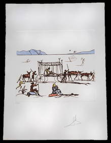
SALVADOR DALI (FRANCE/SPAIN, 1904-1989)Thomaston Place Auction Galleries4.4(386)See Sold PriceFeb 25, 2024
Original Milo Modern Art Bull Bronze Statue Figure Abstract Mid CenturyHouse of Treasure4.4(50)See Sold PriceFeb 29, 2024
Bronze Sculpture Statue Abstract Bull Horns Figurine Stock Broker Sale Gift DecorHouse of Treasure4.4(50)See Sold PriceFeb 29, 2024
Salvador Dali Monochromatic Engraving Titled LA DaliHeritage Gallery Auctions4.4(56)See Sold PriceMar 10, 2024
16 page stamp album Monaco, Spain, France, Portugal 1850-1980Bazaar of Persia4.3(23)See Sold PriceFeb 24, 2024
Salvador Dali "Judgement" Color Etching & AquatintNapoleon's Fine Art4.4(75)See Sold PriceFeb 25, 2024
Salvador Dali "The Age of Anxiety" Color LithographNapoleon's Fine Art4.4(75)See Sold PriceFeb 25, 2024
Salvador Dali Philosophy Illuminated by the LightNapoleon's Fine Art4.4(75)See Sold PriceFeb 25, 2024
Signed Original Fierce Bull Bronze Sculpture - 5.5" x 11"Weatherham Estate Treasures3.9(157)See Sold PriceMar 14, 2024
Pair of Large Noble Heraldic Shields in Renaissance carved wood, Spain or Portugal 16th century -Templum Fine Art Auctions4.3(8)See Sold PriceFeb 28, 2024
Book: A Concise Historical, Biographical & Genealogical Atlas of the Principal Events in theClaydon Auctioneers Ltd4.3(125)See Sold PriceFeb 26, 2024
Vintage Poster Air France Poster, Spain, 1960 By François VERNIER OriginalJasper524.5(9.8k)See Sold PriceFeb 28, 2024
Guthrie, William 1812 Antique Map. Spain and PortugalAlbion Auctions4.6(336)See Sold PriceMar 01, 2024
Joseph Meyer - Set of 20 Prints - Views of Austria - Germany - Italy - Switzerland - France - SpainProverde Auctions4.3(3)See Sold PriceFeb 28, 2024
The Last Coins of Europe 12 Coins Set - Spain, Portugal, France, Italy, Ireland, Belgium, Luxemburg,Andrew's Coin & Jewelry4.5(209)See Sold PriceMar 07, 2024