ATLAS of ANTIENT GEOGRAPHY by SAMUEL BUTLER 1843John McInnis Auctioneers,LLC4.6(502)See Sold PriceFeb 24, 2024
18TH C. ANTIQUE MAP: FRENCH & INDIAN WAR, FRAMEDThomaston Place Auction Galleries4.4(386)See Sold PriceFeb 24, 2024
Rand McNally Railroad Map Cabinet w/ 21 Railroad MapsRail & Road Auctions4.6(165)See Sold PriceMar 08, 2024
Keith Haring - Ink on New York Map, Best Buddies, Inscribed, Signed, and DatedSapphire Auction Gallery4(67)See Sold PriceMar 02, 2024
LATE 17TH C. FRENCH MAP OF THE NEW WORLD BY ALEXIS-HUBERT JAILLOT (1632-1712)Thomaston Place Auction Galleries4.4(386)See Sold PriceFeb 24, 2024
Central Railroad of New Jersey Map of Sandy Hook Route-ca. 1903JM Hobby Supply and Railroad Artifact Auctions4.4(126)See Sold PriceFeb 24, 2024
Lot of Six Mixed Atlas Box Cars-HO Scale-New in BoxJM Hobby Supply and Railroad Artifact Auctions4.4(126)See Sold PriceFeb 25, 2024
Rand McNally/Santa Fe Railroad Map of Iowa-1912JM Hobby Supply and Railroad Artifact Auctions4.4(126)See Sold PriceFeb 24, 2024
NICOLAES VISSCHER (NETHERLANDS, 1618-1709) MAP OF THE NEW WORLDThomaston Place Auction Galleries4.4(386)See Sold PriceFeb 24, 2024
17TH C. WORLD MAP BY NICOLAES VISSCHER (NETHERLANDS, 1618-1709)Thomaston Place Auction Galleries4.4(386)See Sold PriceFeb 24, 2024
Lot of Six Mixed Atlas Cabooses-HO Scale-New in BoxJM Hobby Supply and Railroad Artifact Auctions4.4(126)See Sold PriceFeb 25, 2024
SoldJOHN TALLIS - Islands in the AtlanticJOHN TALLIS in the United Kingdom 1817 - 1876 JOHN RAPKIN in the United Kingdom 1813 - 1899 Islands in the Atlantic. 1850 Steel engraving Signed and titled Sizes 27.6 x 35.8 cm Comes from the work "ThSee Sold Price
John Tallis, 1851 Map of Islands in the Atlantic.With vignette views and decorative borders. Includes Pegasus Bermuda certificate. Image: 14" x 10".See Sold Price
SoldTallis, John (Pub) 1852 Map. Islands in the AtlanticShowing Canary Islands, Madeira and Bermuda. Steel Engraved Map with Original Outline Hand Color Published 1852-56 by John Tallis, London for "The Universal Pronouncing Dictionary" by Thomas Wright. DSee Sold Price
Tallis map of Atlantic Islands with vignettesTitle: Islands in the Atlantic Author: Tallis, John Description: Steel-engraved map, hand-colored in outline; 6 engraved vignettes. 32x22.5 cm. (12½x8¾") plus decorative border.Drawn and engraved bySee Sold Price
SoldTallis: Map of Islands of the Atlantic, 1853Islands of the Atlantic - Bermuda, Canary & Azores by Tallis. Original lithograph by John Tallis & Company of London, c. 1853. Map features Azores, Madeira, Bermuda, Canary & Cape Verde Islands. VingnSee Sold Price
SoldISLANDS IN THE ATLANTIC, TALLIS MAP, 1851Illustrations drawn and engraved by H. Winkles, map drawn and engraved by J. Rapkin. John Tallis, although he only issued a World Atlas, is among the best-known of all map-makers.See Sold Price
SoldIslands in the Atlantic19th Century hand tinted engraved map titled "Islands in the Atlantic" with illustrations by Henry Winkle and map drawn by J. Rapkin. With inscription "John Tallis & Company London New York". Sight SiSee Sold Price
Sold19thc Map: West India Islands, John Tallis & CoFramed 19th century antique map. West India Islands, John Tallis & Company, London and New York, Published 1851. Hand colored, the map drawn and engraved by J. Rapkin. The illustrations by H. Warren &See Sold Price
SoldThree Maps of the West IndiesThe West Indies from the Best Authorities, c. 1790. West Indies from the Best Authorities. C. Brightly & E. Kinnersley, Bungay, Suffolk, c. 1806. West India Islands. John Tallis, J. Rapkin c. 1851. ImSee Sold Price
John Tallis: Map of Channel Islands, 1850Map: Channel Islands Maker: John Tallis Date: ca. 1850 Origin: London Size: 13 x 10 inches This is an ornate and highly decorative map illustrates Jersey & Guernsey with an English Channel inset. TheSee Sold Price
Sold1851 Tallis Map of Islands in the Atlantic1851 Tallis Map of Islands in the Atlantic J. Tallis 1851 London 14 x 10 in. plus matting Beautiful steel engraved map consisting of four maps of the islands: the island groups of Cape Verde, CanariesSee Sold Price
SoldJOHN TALLIS MAP OF POLYNESIA & PACIFIC ISLANDSWith COA. Steelplate engraving, dated 1851. Spots of hand coloring. Dimensions: (Frame) H 19.25" x W 22.5", (Sight) H 10.5" x W 14" Condition: No issues to note.See Sold Price
Islands in the Indian Ocean Map, Tallis, 1851Islands in the Indian Ocean Map. The superb Atlantic Islands map from Tallis' Illustrated Atlas extending from the east coast of Africa and Madagascar to southern Indian, Ceylon, and Southeast Asia. WSee Sold Price
SoldMALAY, ARCHIPELAGO,OR EAST INDIA ISLANDS MAPMALAY, ARCHIPELAGO,OR EAST INDIA ISLANDS MAP BY JOHN TALLIS & COMPANY, LONDON & NEW YORK. ILLUSTRATIONS BY H. WARREN & ENGRAVED BY T. SMITH. MAP DRAWN AND ENGRAVED BY J RAPKIN. 10 AND 1/2 BY 14 AND 1/See Sold Price
Lot of 4 steel-engraved maps by John TallisTitle: Lot of 4 steel-engraved maps by John Tallis Author: Tallis, John Description: Includes: Islands in the Indian Ocean. * Northern India. * Russia in Asia. * Turkey in Europe. Together, 4 steel-enSee Sold Price
SoldTallis, John (Pub) 1852 Map Islands in the Indian OceanSteel Engraved Map with Original Outline Hand Color Published 1852-56 by John Tallis, London for "The Universal Pronouncing Dictionary" by Thomas Wright. Drawn & Engraved by John Rapkin. Centre fold aSee Sold Price
SoldFIFTEEN MAPS, SCENIC ENGRAVINGSMAPS, SCENIC ENGRAVINGS, 19th c.- 20th c: Three Johnson & Ward steele engraved maps c, 1865; John Tallis & Co. map of West India Islands; St. Goar on the Rhein, Germany; handcolored steele engraving,See Sold Price
SoldAtlantic Islands. The New General Atlas. John Thomson.Maker: Thomson, John. Origin: Edinburgh, Thomson, 1817. Medium: Original engraving hand-colored at publication. Sheet size: 21 x 26 in. No Reserve: This lot starts at $1 and has no reserve as a courteSee Sold Price
SoldTallis, John (Pub) 1852 Map Falkland Islands, PatagoniaSteel Engraved Map with Original Outline Hand Color Published 1852-56 by John Tallis, London for "The Universal Pronouncing Dictionary" by Thomas Wright. Drawn & Engraved by John Rapkin. Centre fold aSee Sold Price
SoldTallis, John (Pub) 1852 Map. Channel IslandsSteel Engraved Map with Original Outline Hand Color Published 1852-56 by John Tallis, London for "The Universal Pronouncing Dictionary" by Thomas Wright. Drawn & Engraved by John Rapkin. Centre fold aSee Sold Price
SoldTallis (John) New Zealand; PolynesiaTallis (John) New Zealand; Polynesia, or Islands in the Pacific Ocean; Australia,with decorative borders and vignette views, 3 engraved maps by Rapkin, with original outline hand-colouring, c.See Sold Price
Atlantic Islands.Title/Content of Map: Atlantic Islands. Date Printed: 1817 Cartographer: THOMSON, JOHN & CO. Size: 22.75X23.3 No.40 from Thomson's New General Atlas 1817. T. Clerk sculpt. Unusual image showing six reSee Sold Price
Atlantic Islands.Title: Atlantic Islands. Publication Date: 1817 Cartographer: THOMSON, JOHN & CO.Publisher: JOHN THOMSON, JUNR. & CO. Size: 22.75Height - 23.3Width No.40 from Thomson's New General Atlas 1817. T. ClerSee Sold Price
SoldTallis, John (Pub) 1852 Map. West India IslandsSteel Engraved Map with Original Outline Hand Color Published 1852-56 by John Tallis, London for "The Universal Pronouncing Dictionary" by Thomas Wright. Drawn & Engraved by John Rapkin. Centre fold aSee Sold Price
Illuminated Manuscript Leaf of John the EvangelistSchmidt's Antiques Inc. Since 19114.8(431)See Sold PriceMar 02, 2024
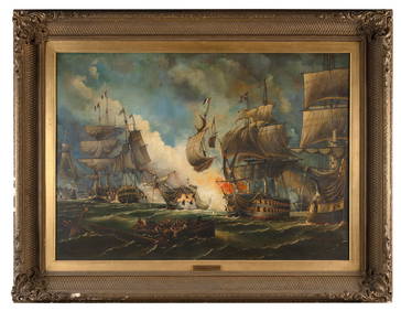
WILLIAM GRIFFIN (United Kingdom, 19th Century), "Battle of the Glorious 1st June"., Oil on canvas,Eldred's4.7(409)See Sold PriceFeb 27, 2024
Medieval Stained Glass Panel with Saint John on PatmosTimeLine Auctions Ltd.4.5(183)See Sold PriceMar 05, 2024
Hiroshi Sugimoto - North Atlantic Ocean, Cape Breton IslandSapphire Auction Gallery4(67)See Sold PriceMar 02, 2024
From the Atlantic to the Pacific 1902North American Artifact Auctions4.6(182)See Sold PriceApr 20, 2024
JURASSIC PARK (1993) - Production-Made Sick Triceratops Spikes in Frill DisplayPropstore4.2(6)See Sold PriceMar 12, 2024
Book: The History of the Island of Minorca / Menorca, by John Armstrong. Printed for L. Davis andClaydon Auctioneers Ltd4.3(125)See Sold PriceFeb 26, 2024
NORTHERN AFRICA. Morocco Tunisia Algeria. Caravan routes. RAPKIN/TALLIS 1851 mapJasper524.5(9.8k)See Sold PriceFeb 28, 2024
NORTHERN AFRICA. Morocco Tunisia Algeria. Caravan routes.TALLIS/RAPKIN 1851 mapJasper524.5(9.8k)See Sold PriceFeb 28, 2024
NORTHERN AFRICA. Morocco Tunisia Algeria. Caravan routes. RAPKIN/TALLIS 1851 mapJasper524.5(9.8k)See Sold PriceFeb 28, 2024
Framed John Barber S&N Deal Island MorningRapid Estate Liquidators and Auction Gallery4.5(1.1k)See Sold PriceFeb 28, 2024
The Christian Economy Translated from Greek 1839Rapid Estate Liquidators and Auction Gallery4.5(1.1k)See Sold PriceFeb 28, 2024