ATLAS of ANTIENT GEOGRAPHY by SAMUEL BUTLER 1843John McInnis Auctioneers,LLC4.6(502)See Sold PriceFeb 24, 2024
18TH C. ANTIQUE MAP: FRENCH & INDIAN WAR, FRAMEDThomaston Place Auction Galleries4.4(386)See Sold PriceFeb 24, 2024
Rand McNally Railroad Map Cabinet w/ 21 Railroad MapsRail & Road Auctions4.6(165)See Sold PriceMar 08, 2024
Keith Haring - Ink on New York Map, Best Buddies, Inscribed, Signed, and DatedSapphire Auction Gallery4(67)See Sold PriceMar 02, 2024
LATE 17TH C. FRENCH MAP OF THE NEW WORLD BY ALEXIS-HUBERT JAILLOT (1632-1712)Thomaston Place Auction Galleries4.4(386)See Sold PriceFeb 24, 2024
Central Railroad of New Jersey Map of Sandy Hook Route-ca. 1903JM Hobby Supply and Railroad Artifact Auctions4.4(126)See Sold PriceFeb 24, 2024
Lot of Six Mixed Atlas Box Cars-HO Scale-New in BoxJM Hobby Supply and Railroad Artifact Auctions4.4(126)See Sold PriceFeb 25, 2024
Rand McNally/Santa Fe Railroad Map of Iowa-1912JM Hobby Supply and Railroad Artifact Auctions4.4(126)See Sold PriceFeb 24, 2024
NICOLAES VISSCHER (NETHERLANDS, 1618-1709) MAP OF THE NEW WORLDThomaston Place Auction Galleries4.4(386)See Sold PriceFeb 24, 2024
17TH C. WORLD MAP BY NICOLAES VISSCHER (NETHERLANDS, 1618-1709)Thomaston Place Auction Galleries4.4(386)See Sold PriceFeb 24, 2024
Lot of Six Mixed Atlas Cabooses-HO Scale-New in BoxJM Hobby Supply and Railroad Artifact Auctions4.4(126)See Sold PriceFeb 25, 2024
SoldJohn Speed (British, 1552-1629) Engraved Map of SussexJohn Speed (British, 1552-1629) Engraved Map of Sussex with Colors British, 17th century. An engraved and hand-colored map of Sussex, full title: Sussex Described and divided into Rapes with the situaSee Sold Price
SoldJohn Speed (British, 1552-1629) Engraved Map ofJohn Speed (British, 1552-1629) Engraved Map of Scotland with Colors British, 17th century. An engraved map of Scotland with hand-coloring, full title: The Kingdome of Scotlantd in cartouche at upperSee Sold Price
John Speed (British 1552-1629)/Anglesey, 1610/handJohn Speed (British 1552-1629)/Anglesey, 1610/hand coloured engraved map, 39cm x 51cmSee Sold Price
SoldHand colored engraved map, John Speed, BritainFramed hand colored copper engraved map, ""Britain as it was Divided in the time of the English Saxons,"" by John Speed (British,1552-1629), image: 15""h x 20""w, overall: 26""h x 31""wSee Sold Price
SoldJohn Speed "The Countye Palatine of Chester" MapJohn Speed (British, 1552-1629) "The Countye Palatine of Chester with that Most Ancient Citie Described," engraved map on paper, 17th century, richly hand-colored, the image detailed with figures, seaSee Sold Price
John Speed (British 1552-1629)/Rutlandshire with OakhamJohn Speed (British 1552-1629)/Rutlandshire with Oakham and Stanford with the arms of the Duke of Rutland/hand coloured engraved map, 38cm x 51cmSee Sold Price
Sold17th C. John Speed, Huntington & Ely MapJohn Speed (British, 1552-1629), "Huntington, both Shire and Shire Town with the ancient citie Ely Described," hand colored, double engraved-page map originally created by noted cartographer, John SpeSee Sold Price
SoldJohn Speed (1552-1629) British 'Oxfordshire', aJohn Speed (1552-1629) British 'Oxfordshire', a hand-coloured engraved map, titled 'Oxfordshire described with ye Citie and the Armes of the Colledges of ty famous University. Ao. 1605.', with an inseSee Sold Price
SoldJohn Speed (1552-1629) British after John NordenJohn Speed (1552-1629) British after John Norden (c.1546/48-c.1626) British. "Sussex", Map, 15.25" x 20.25".See Sold Price
Speed, Map of AsiaAsia. John Speed (1552-1629). Engraved map. London: G. Humble, 1626. 17 1/2 x 21 3/4 inches sheet, 26 1/2 x 31 1/2 inches framed. This beautiful carte-a-figures map is the first English printed map ofSee Sold Price
SoldSpeed Map of CarolinaA New Description of Carolina. John Speed (c. 1552-1629). Engraved map with original hand color. London, 1676. 16 3/4 x 22 inches visible, 22 x 27 inches framed.See Sold Price
SoldSpeed Map of AfricaAfricae, Described, the Manners of their Habits, and Buildinge…John Speed (1552-1629). Engraved map with original hand color. London: Bassett & Chiswell, 1676. 17 1/4 x 22 inches sheet, 26 1/2 x 31See Sold Price
Speed Map of AsiaSPEED, John (1551 or 1552 - 1629). Asia. Copperplate Engraved Map. From A Prospect of the Most Famous Parts of the World...with these Empires and Kingdoms. London: 1676. 17 1/8" x 22" sheet; 26 1/2" xSee Sold Price
SoldSpeed Map of Carolina, 1676SPEED, John (1552-1629). A New Description of Carolina. Engraved map with original hand color. London: 1676. 16 3/4” x 22” sheet, 21” x 27” framed. Important early map of the Carolinas to rendSee Sold Price
Speed Map of East Indies*** START PRICE IS THE RESERVE *** [Asia] SPEED, John (1552-1629). A New Map of East India. Engraved map. London: 1676. 17" x 21 1/2" sheet. Comparable: Bloomsbury Auctions, 2013 - £1,769. The mSee Sold Price
SoldSpeed Map of AmericaSPEED, John (1552-1629). America, with those known parts in that unknowne worlde. Engraved map. London: G. Humble, 1626. 17 1/4" x 21 3/4" sheet, 26 1/2" x 31 1/2" framed. English text on verso, threeSee Sold Price
Speed Map of Dorsetshyre*** START PRICE IS THE RESERVE *** [Europe] SPEED, John (1552-1629). Dorsetshyre with the Shyre-Towne Dorechester Described... Engraved map with hand color in full. London, c. 1610. 16" x 21" visible,See Sold Price
Speed Octavo Atlas*** START PRICE IS THE RESERVE *** [Atlas] SPEED, John (1552-1629). A Prospect of the Most Famous Parts of the World. London: Roger Rea, 1668. Oblong 8vo., (4 x 6 4/8 inches). Fine engraved double-hemSee Sold Price
SoldJOHN SPEED (BRITISH, 1552-1629) MAP OF THE WORLDJOHN SPEED (BRITISH, 1552-1629) MAP OF THE WORLD, hand-colored engraving on paper, titled "A New and Accurat Map of the World Drawne according to ye truest Descriptions latest Discoveries & best obserSee Sold Price
SoldJOHN SPEED (BRITISH, 1552-1629) MAP OF THE WORLDJOHN SPEED (BRITISH, 1552-1629) MAP OF THE WORLD, (UPDATED 6/14/16) hand-colored engraving on laid paper, titled "A New and Accurat Map of the World Drawne according to ye truest Descriptions latest DSee Sold Price
SoldKingdom of IrelandJohn Speed (1552-1629). Engraved map. London: 1610 (1676). 17 1/4 x 22 inches. A rare, early printing of John Speed’s renowned map of Ireland. The map is decorated with a panel of costume figures deSee Sold Price
SoldThe WorldJohn Speed (1552-1629). Engraved map. London: 1626. 17 1/2 x 21 3/4 inches, 26/1/2 x 31 1/2 inches framed. The work of John Speed’s ‘New and Accurat Map of the World’ has an extraordinary degreeSee Sold Price
SoldAmericaJohn Speed (1552-1629). Engraved map. London: 1626. 17 1/2 x 21 3/4 inches, 26/1/2 x 31 1/2 inches framed. John Speed’s masterpiece map of America, published in 1676, one was still very much influenSee Sold Price
SoldAfricaJohn Speed (1552-1629). Engraved map. London: 1626. 17 1/2 x 21 3/4 inches, 26/1/2 x 31 1/2 inches framed. John Speed’s map of Africa is very handsome. It sits proudly in the middle, while all arounSee Sold Price
17TH C. MAP OF THE BERKSHIRES BY JOHN SPEED, FRAMEDThomaston Place Auction Galleries4.4(386)See Sold PriceFeb 24, 2024
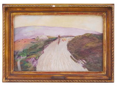
JOHN BARAGWANATH KING BRITISH WATERCOLOR PAINTINGAntique Arena Inc.4.5(852)See Sold PriceFeb 24, 2024
Arrowsmith & Lewis - Map of North AmericaTrillium Antique Prints & Rare Books4.5(30)See Sold PriceFeb 24, 2024
Arrowsmith & Lewis - Map of LouisianaTrillium Antique Prints & Rare Books4.5(30)See Sold PriceFeb 24, 2024
Arrowsmith & Lewis - Map of the United StatesTrillium Antique Prints & Rare Books4.5(30)See Sold PriceFeb 24, 2024
Map: An engraved and hand coloured map titled The Countie of Nottingham described The Shire TownesClaydon Auctioneers Ltd4.3(125)See Sold PriceFeb 26, 2024
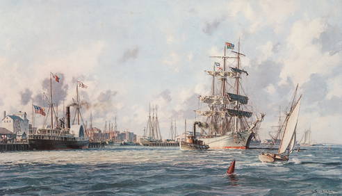
John Stobart Galveston the Bark Elissa Signed LithographConcept Art Gallery4.7(508)See Sold PriceMar 06, 2024
Fielding (Henry) The Works, with An Essay on His Life and Genius by Arthur Murphy, 10 vol., newForum Auctions4.3(52)See Sold PriceFeb 29, 2024
Kent & Sussex.- Moss (W.G.) The History and Antiquities of the Town and Port of Hastings, 1824; andForum Auctions4.3(52)See Sold PriceFeb 29, 2024
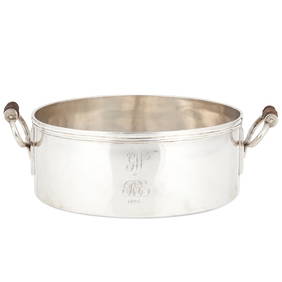
Fifteen American Fiddleback Coin Silver Spoons by Various MakersGray's Auctioneers4.5(186)See Sold PriceMar 06, 2024
Churchill & Nieuhof 1744 Folio Map. Batavia Indonesia East IndiesAlbion Auctions4.6(336)See Sold PriceMar 01, 2024
Paterson & Mogg 1822 Pair of British Road Maps. Deal, Hythe, Shoreham, ChichesterAlbion Auctions4.6(336)See Sold PriceMar 01, 2024
Herman Moll A New Map of Ye North Parts of AmericaWillow Auction House4.5(283)See Sold PriceMar 14, 2024