JOHN REID - MAP OF NORTH AMERICA, 1796John Reid - Map Of North America, 1796 - 36 X 28 3/4 In. - This Giclée Print Is Gallery Stretched And Ready To Hang Or Lean Against A Wall, Or Display On An Easel. - A Giclée Print Is The Highest QuSee Sold Price
JOHN REID - MAP OF NORTH AMERICA, 1796John Reid - Map Of North America, 1796 - 36 X 28 3/4 In. - This Giclée Print Is Gallery Stretched And Ready To Hang Or Lean Against A Wall, Or Display On An Easel. - A Giclée Print Is The Highest QuSee Sold Price
John Reid - Map Of North America, 1796John Reid - Map Of North America, 1796 Size: 36 X 28 3/4 In. - This Is A Gallery Stretched Giclee Print On Canvas. The Piece Was Printed On High Quality Artist Grade 350 Gsm, Acid-free, Archival CanvaSee Sold Price
JOHN REID - MAP OF NORTH AMERICA, 1796 - Giclée onJOHN REID - MAP OF NORTH AMERICA, 1796 - Giclée on Canvas 36 x 28 3/4 in.See Sold Price
JOHN REID - MAP OF NORTH AMERICA, 1796John Reid - Map Of North America, 1796 - 36 X 28 3/4 In. - This Giclée Print Is Gallery Stretched And Ready To Hang Or Lean Against A Wall, Or Display On An Easel. - A Giclée Print Is The Highest QuSee Sold Price
SoldGeneral Map of North America...John Reid & W. Winterbotham. from the American Atlas. New York: J. Reid, L. Wayland & C. Smith, 1796. Engraved Map with Orignal Hand-color in Outline. 16 1/2 x 20 inchesSee Sold Price
Sold18th century map of North America,18th century map of North America, "A General Map of North America Drawn from the Best Surveys", from [American Atlas], published by John Reid, 1796, engraving on laid paper, page 16-1/2 x 19-3/8 in.;See Sold Price
JOHN REID - MAP OF SOUTH AMERICA, 1796JOHN REID - MAP OF SOUTH AMERICA, 1796 - 36 x 29 3/8 in. - Museum Wrapped The Piece Of Art Is Ready To Hang Or Lean Against A Wall, Or Display On An Easel. - A Giclée Print Is The Highest Quality PriSee Sold Price
JOHN REID - MAP OF SOUTH AMERICA, 1796 - GICLÉE ONJohn Reid - Map Of South America, 1796 - Giclée On Canvas 36 X 29 3/8 In. - A Giclée Print Is The Highest Quality Print Available Today. Because There Is No Visible Dot Screen Pattern, The ResultingSee Sold Price
JOHN REID - MAP OF SOUTH AMERICA, 1796John Reid - Map Of South America, 1796 - Giclée On Canvas - 36 X 29 3/8 In.~~A giclée print falls between serigraph and lithograph in quality. Although they can be made on paper, Giclees on canvas mSee Sold Price
JOHN REID - MAP OF SOUTH AMERICA, 1796John Reid - Map Of South America, 1796 - 36 X 29 3/8 In. - Giclée Print - Gallery Stretched - Ready to hang.See Sold Price
John Reid - Map Of South America, 1796John Reid - Map Of South America, 1796 Size: 36 X 29 3/8 In. - This Is A Gallery Stretched Giclee Print On Canvas. The Piece Was Printed On High Quality Artist Grade 350 Gsm, Acid-free, Archival CanvaSee Sold Price
JOHN REID - MAP OF SOUTH AMERICA, 1796John Reid - Map Of South America, 1796 - 36 X 29 3/8 In. - This Giclée Print Is Gallery Stretched And Ready To Hang Or Lean Against A Wall, Or Display On An Easel. - A Giclée Print Is The Highest QuSee Sold Price
JOHN REID - MAP OF SOUTH AMERICA, 1796John Reid - Map Of South America, 1796 - 36 X 29 3/8 In. - This Giclée Print Is Gallery Stretched And Ready To Hang Or Lean Against A Wall, Or Display On An Easel. - A Giclée Print Is The Highest QuSee Sold Price
JOHN REID - MAP OF SOUTH AMERICA, 1796JOHN REID - MAP OF SOUTH AMERICA, 1796 - 36 x 29 3/8 in. - Museum Wrapped The Piece Of Art Is Ready To Hang Or Lean Against A Wall, Or Display On An Easel. - A Giclée Print Is The Highest Quality PriSee Sold Price
JOHN REID - MAP OF THE UNITED STATES OF AMERICA, 1796John Reid - Map Of The United States Of America, 1796 - 36 X 28 3/4 In. - This Giclée Print Is Gallery Stretched And Ready To Hang Or Lean Against A Wall, Or Display On An Easel. - A Giclée Print IsSee Sold Price
JOHN REID - MAP OF THE UNITED STATES OF AMERICA, 1796John Reid - Map Of The United States Of America, 1796 - 36 X 28 3/4 In. - This Giclée Print Is Gallery Stretched And Ready To Hang Or Lean Against A Wall, Or Display On An Easel. - A Giclée Print IsSee Sold Price
John Reid - Map Of The United States Of America, 1796John Reid - Map Of The United States Of America, 1796 Size: 36 X 28 3/4 In. - This Is A Gallery Stretched Giclee Print On Canvas. The Piece Was Printed On High Quality Artist Grade 350 Gsm, Acid-free,See Sold Price
JOHN REID - MAP OF THE UNITED STATES OF AMERICA, 1796John Reid - Map Of The United States Of America, 1796 - 36 X 28 3/4 In. - Giclée Print - Gallery Stretched - Ready to hang.See Sold Price
SoldMAP OF THE UNITED STATES OF AMERICA, 1796"JOHN REID"MAP OF THE UNITED STATES OF AMERICA, 1796"30 x 23 7/8 in. This Giclée is high-resolution and of the highest quality, has a color permanence rating in excess of 100 years. Printed on Canvas,See Sold Price
Reduced Section of a General Map of North America DrawnTitle: Reduced Section of a General Map of North America Drawn from the Best Surveys 1795... Prublication Date: c1861 Cartographer: LT. WARREN'S MEMOIR PLATE I Publisher: JOHN REID /J. BIEN (LITH.) SiSee Sold Price
Sold2 Antique maps2 Antique maps- John Wilkes- North America- engraved map wiht hand-coloring, 1796, engraved by Neele, fair condition with paper toning and staining throughout; and Cook/Hogg- Sketch of Nootka Sound, ASee Sold Price
Tanner: Antique Map of South America, 1796Map: A General Map of South America from the Best Surveys, 1796. Publication Date: 1796 Authors: John Reid, B. Tanner Publisher: John Reid Size: Folio – 14.25 H x 17.5 W Inches B. Tanner sculpt. PolSee Sold Price
Tanner: Map of South America from the Best Surveys 1796Map: A General Map of South America from the Best Surveys, 1796. Date: 1796 Authors: JOHN REID, TANNER, B. Publisher: JOHN REID Size: Folio – 14.10 H x 17.30 W Inches The South America map from theSee Sold Price
Arrowsmith & Lewis - Map of North AmericaTrillium Antique Prints & Rare Books4.5(30)See Sold PriceFeb 24, 2024
Carey, pub. 1796 - Map of the Tennassee State formerly part of North Carolina (Tennessee)Trillium Antique Prints & Rare Books4.5(30)See Sold PriceFeb 24, 2024
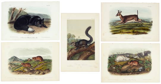
Audubon - 8 Quadruped LithographsTrillium Antique Prints & Rare Books4.5(30)See Sold PriceFeb 24, 2024
Audubon, Imperial Folio - 4 Lithographs of Squirrel, Rat, MiceTrillium Antique Prints & Rare Books4.5(30)See Sold PriceFeb 24, 2024
Audubon, Imperial Folio - American Cross Fox. 6Trillium Antique Prints & Rare Books4.5(30)See Sold PriceFeb 24, 2024
Audubon, Imperial Folio - Canada Lynx. 16Trillium Antique Prints & Rare Books4.5(30)See Sold PriceFeb 24, 2024
Map: An 18thC engraved and hand coloured map of North America and South America, titled DeClaydon Auctioneers Ltd4.3(125)See Sold PriceFeb 26, 2024
New and Correct Map of North America With the West India Islands,Jasper524.5(9.8k)See Sold PriceFeb 27, 2024
First 50 plates from Audubon's Quad Quarto (all in Vol. I)PBA Galleries4.7(383)See Sold PriceMar 07, 2024
Nearly complete set of plates from Vol. III Quad QuartoPBA Galleries4.7(383)See Sold PriceMar 07, 2024