ATLAS of ANTIENT GEOGRAPHY by SAMUEL BUTLER 1843John McInnis Auctioneers,LLC4.6(502)See Sold PriceFeb 24, 2024
18TH C. ANTIQUE MAP: FRENCH & INDIAN WAR, FRAMEDThomaston Place Auction Galleries4.4(386)See Sold PriceFeb 24, 2024
Rand McNally Railroad Map Cabinet w/ 21 Railroad MapsRail & Road Auctions4.6(165)See Sold PriceMar 08, 2024
Keith Haring - Ink on New York Map, Best Buddies, Inscribed, Signed, and DatedSapphire Auction Gallery4(67)See Sold PriceMar 02, 2024
LATE 17TH C. FRENCH MAP OF THE NEW WORLD BY ALEXIS-HUBERT JAILLOT (1632-1712)Thomaston Place Auction Galleries4.4(386)See Sold PriceFeb 24, 2024
Central Railroad of New Jersey Map of Sandy Hook Route-ca. 1903JM Hobby Supply and Railroad Artifact Auctions4.4(126)See Sold PriceFeb 24, 2024
Lot of Six Mixed Atlas Box Cars-HO Scale-New in BoxJM Hobby Supply and Railroad Artifact Auctions4.4(126)See Sold PriceFeb 25, 2024
Rand McNally/Santa Fe Railroad Map of Iowa-1912JM Hobby Supply and Railroad Artifact Auctions4.4(126)See Sold PriceFeb 24, 2024
NICOLAES VISSCHER (NETHERLANDS, 1618-1709) MAP OF THE NEW WORLDThomaston Place Auction Galleries4.4(386)See Sold PriceFeb 24, 2024
17TH C. WORLD MAP BY NICOLAES VISSCHER (NETHERLANDS, 1618-1709)Thomaston Place Auction Galleries4.4(386)See Sold PriceFeb 24, 2024
Lot of Six Mixed Atlas Cabooses-HO Scale-New in BoxJM Hobby Supply and Railroad Artifact Auctions4.4(126)See Sold PriceFeb 25, 2024
John Cary: Map of the Middle States, 1806Map: Middle States Maker: John Cary Date: 1806 Size: 30 x 30 inches Medium: Original copperplate engraving John Cary (1754-1835) was an English cartographer who is known for his maps, globes, and hisSee Sold Price
SoldJohn Cary, London, Hand-Colored Map of U.S.John Cary, London, Hand-Colored Engraved Map of the United States, 1806, handsomely presented in a gilt-edged gold leaf and watercolor-banded pale blue French mat within a narrow giltwood frame in theSee Sold Price
SoldCary, ''A New Map of the United States...,'' 1806[United States]. John Cary. A New Map Of The United States Of America, From the latest Authorities. Double-page engraved map of the U.S. extending to Mississippi River. Lon: Cary, 1806. 20 x 22 3/8 inSee Sold Price
SoldCary's Map of the Southern United States, 1806A New Map of Part of the United States of North America Containing the Carolinas and Georgia, Also the Floridas and Part of the Bahama Islands, etc. by John Cary, 1806, a partially hand-coSee Sold Price
SoldCary Map of the United States of America 1806Title: A New Map of the United States of America from the Latest Authorities Author: Cary, John Description: Copper-engraved map, hand-colored. 46x51 cm. (18x20").The U.S. to just beyond the MississipSee Sold Price
SoldJohn Cary. A New Map of the United States of AmeJohn Cary. A New Map of the United States of America, from the Latest Authorities.<See Sold Price
Sold1806 Map of the United States of America, Cary1806 Engraved Map entitled "A New Map of the United States of America, From the Latest Authorities", by John Cary, Engraver, map measures H.22" x W.24"; frame dimensions slightly largerSee Sold Price
SoldCARY, JOHN. A New Map of the United States ofCARY, JOHN. A New Map of the United States of America. Double-page engraved map, 470x585 mm, wide margins; hand-colored; some staining in the lower margin (not near the image). London, 1806 All itemsSee Sold Price
SoldJohn Cary 1806, Three Maps of North AmericaThree hand colored maps of North America by John Cary, London, 1806. 1st map - "A New Map of North America" showing continent of North America. 2nd map - "A New Map of Part of the United States contaiSee Sold Price
SoldJOHN CARY, HAND COLORED MAP, 1806, PART OF USAJOHN CARY, HAND COLORED MAP, 1806, "A NEW MAP OF PART OF THE UNITED STATES OF NORTH AMERICA":17 7/8" x 20 1/4", unframed. Ex. Collection Nancy and the late G. Mennen Williams.See Sold Price
Cary (John) - A New Map of Part of the United States offrom New Brunswick to North Carolina, engraved map with original hand-colouring in outline, 520 x 580mm., central vertical fold, some faint offsetting, 1806.See Sold Price
SoldCARY, JOHN. A New Map of Part of the United StCARY, JOHN. A New Map of Part of the United States of North America. Engraved map, 510x575 mm, wide margins; hand-colored; minor scattered soiling. London, 1806 New York, Vermont, New Hampshire, MassaSee Sold Price
SoldA New Map of the United States of AmericaBy John Cary, Engineer, 1806. "From the Latest Authorities." Small tears on margins, not affecting image. Quite soiled in one area. 21 3/8" x 25 1/8". From the Mill Mountain, Virginia estate of W.P. HSee Sold Price
SoldJohn Cary (British, 1754-1835)John Cary (British, 1754-1835), "A New Map of Part of The United States of North America Containing the Carolinas and Georgia, also The Floridas and Part of The Bahama Islands & C.", London, 1806, hanSee Sold Price
SoldA map of Georgia the Carolinas Floridas and Bahamas by John Cary 1806John Cary, a large, early 19th century engraved, colored map titled "A New Map of Part of the United States of North America Containing the Carolinas and Georgia, Also the Floridas and part of the BahSee Sold Price
SoldCary Map of Florida, Georgia, North Carolina, SouthCary, John (British, 1754-1835). A New Map of Part of the United States of North America, Containing the Carolinas and Georgia, also the Floridas and Part of the Bahama Islands. London: 1806. EngravedSee Sold Price
SoldMap, New Map of North America, J. Cary, 1806This lot is a map created by famed cartographer John Cary. It depicts the United States and the rest of North America following the Louisiana Purchase and the changing of borders. The hand-colorings aSee Sold Price
SoldJohn Cary Map, 1806John Cary, "A New Map of North America from the Latest Authorities", London, 1806, hand-colored engraved map, showing the U.S. after the Louisiana Purchase and before the exploration by Lewis & Clark,See Sold Price
SoldJohn Cary, Map United States, Treaty of Peace 1783John Cary (London, 1754-1835) "An Accurate Map of the United States of America, with Part of the Surrounding Provinces agreeable to the Treaty of Peace of 1783", 1783 (created/published) Hand coloredSee Sold Price
SoldJohn Cary Map of North America 1806John Cary, "A New Map of North America from the Latest Authorities", London, 1806, hand-colored engraved map, showing the U.S. after the Louisiana Purchase and before the exploration by Lewis & Clark,See Sold Price
SoldMap of Middle States of America John C. Rufsell 1794Rufsell, John C. Map of the middle states of America... London: H.D. Symonds, 1794Dimensions: 14 1/4" X 18 1/8"Note: Plate from Historical Geographical.. View of the United States. Insert of Long IslaSee Sold Price
SoldAN 1811 UNITED STATES MAP BY JOHN CARYA New Map of Part of the United States of North America Exhibiting the Western Territory, Kentucky, Pennsylvania, Maryland, Virginia & c. also the Lakes Superior Michigan Huron Ontario & Erie with UppSee Sold Price
SoldJohn Cary. A New Map Of America. 1806 [ca. 1808].[Cary, John/America New Map] A NEW MAP OF AMERICA, From the Latest Authorities By John Cary, Engraver. 1806. From an edition of Cary’s “New Universal Atlas.” [C. 1808. Phillis, Atlases, 714 listSee Sold Price
SoldJohn Cary. A NEW MAP OF AMERICA 1806, [ca. 1808].[New World] A NEW MAP OF AMERICA, From the Latest Authorities By John Cary, Engraver. 1806. From an edition of Cary’s “New Universal Atlas.” [C. 1808. Phillis, Atlases, 714 lists this as Plate 5See Sold Price
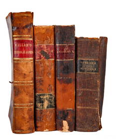
BOOKS on AMERICAN-EUROPEAN HISTORY & KING CHARLESJohn McInnis Auctioneers,LLC4.6(502)See Sold PriceFeb 24, 2024
1963 J.F.K. for US PRESIDENT RE-ELECTION MATERIALJohn McInnis Auctioneers,LLC4.6(502)See Sold PriceFeb 25, 2024
1905 20th Century Atlas of Boone County IllinoisMatthew Bullock Auctioneers4.7(1.8k)See Sold PriceFeb 24, 2024
JOHN J. AUDUBON (1785-1851) LITHOGRAPH, 1948, 19IN x 25IN (48cm x 64cm)The Rug LifeSee Sold PriceMar 07, 2024
JOHN J. AUDUBON (1785-1851) LITHOGRAPH TITLED FORK TAILED FLYCATCHER, 19IN x 25IN (48cm x 64cm)The Rug LifeSee Sold PriceMar 07, 2024
JOHN J. AUDUBON (1785-1851) LITHOGRAPH TITLED CANADA JAY, 19IN x 25IN (48cm x 64cm)The Rug LifeSee Sold PriceMar 07, 2024
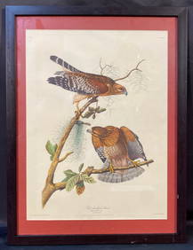
JOHN J. AUDUBON (1785-1851) LITHOGRAPH TITLED RED SHOULDERED HAWK, 19IN x 25IN (48cm x 64cm)The Rug LifeSee Sold PriceMar 07, 2024
Map: A 19thC engraved map titled Gloucestershire from the Best Authorities, after John Cary. Approx.Claydon Auctioneers Ltd4.3(125)See Sold PriceFeb 26, 2024
Map: A 19thC engraved and hand coloured map of Buckingham titled A New Map of BuckinghamshireClaydon Auctioneers Ltd4.3(125)See Sold PriceFeb 26, 2024
Map: A 19thC engraved map of West Riding, titled A Map of the North Part of the West Riding ofClaydon Auctioneers Ltd4.3(125)See Sold PriceFeb 26, 2024
Fielding (Henry) The Works, with An Essay on His Life and Genius by Arthur Murphy, 10 vol., newForum Auctions4.3(52)See Sold PriceFeb 29, 2024


![John Cary. A New Map Of America. 1806 [ca. 1808]. (1 of 3)](https://p1.liveauctioneers.com/179/93063/47518594_1_x.jpg?height=282&quality=70&version=1472482862)
![John Cary. A NEW MAP OF AMERICA 1806, [ca. 1808]. (1 of 3)](https://p1.liveauctioneers.com/179/82189/42599758_1_x.jpg?height=282&quality=70&version=1447864785)