Gothic Revival Stained Glass Window of The ResurrectionSchmidt's Antiques Inc. Since 19114.8(440)See Sold PriceMar 02, 2024
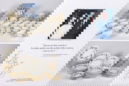
THE FITZGERALD FAMILY TEA and DINNER SERVICEJohn McInnis Auctioneers,LLC4.5(505)See Sold PriceFeb 25, 2024
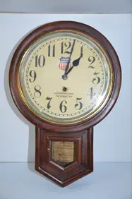
Union Pacific RR Cheyenne, WY Locomotive Shop ClockJM Hobby Supply and Railroad Artifact Auctions4.4(127)See Sold PriceFeb 24, 2024
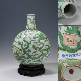
A CHINESE PORCELAIN GREEN ENAMELED DRAGON MOON FLASK BIANHUBerkeley Auction Gallery4.4(16)See Sold PriceMar 03, 2024
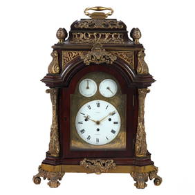
Antique George III Musical Bracket Clock by Hare LondonHill Auction Gallery 4.7(1k)See Sold PriceFeb 28, 2024
No Reserve Early 20th century French / Flemish Design Tapestry 6 ft 2 in x 4 ft 9 in (1.87 m x 1.44Nazmiyal Auctions4.4(36)See Sold PriceFeb 25, 2024
Central Anatolia Konya Antique Rug 4 ft 8 in x 3 ft 8 in (1.42 m x 1.11 m)Nazmiyal Auctions4.4(36)See Sold PriceFeb 25, 2024
PAIR MAGNIFICENT AND LARGE CLOISONNE ENAMEL CRANES INCENSE BURNERSBerkeley Auction Gallery4.4(16)See Sold PriceMar 03, 2024
From Davide Halevim Collection Antique Persian Mohtashem Kashan Rug 10'11" x 7'10" (3.32 m x 2.38 m)Nazmiyal Auctions4.4(36)See Sold PriceFeb 25, 2024
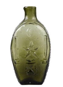
RARE COVENTRY GLASS WORKS MASONIC FLASKJohn McInnis Auctioneers,LLC4.5(505)See Sold PriceFeb 25, 2024
Empire by Buccellati Italy Sterling Silver Flatware Set 99 pieces DinnerBidhaus4.3(773)See Sold PriceFeb 25, 2024
John Cary: A New Map of the Circle of Bavaria, 1799By: John Cary Date: 1799 (Dated) London Dimensions: 18 x 20 inches (45.7 cm x 50.8 cm) Description: This is an authentic hand-colored antique map by the prominent cartographer John Cary, which depictsSee Sold Price
Sold(4) EARLY ENGLISH ENGRAVED MAPS BY JOHN CARYHand-colored Engraved Atlas Folio Maps of Europe, including: 'Circle of Bavaria', 1799; 'County of Tyrol and the Republic of Venice; Duchy of Mantua &c &c', 1799; 'Bohemia and Moravia', 1801; 'CircleSee Sold Price
Sold(4) EARLY MAPS OF EUROPE BY CARYHand colored Engraved Atlas Folio Maps of Europe, by John Cary, including: 'Circle of Bavaria', 1799; 'County of Tyrol and the Republic of Venice; Duchy of Mantua &c', 1799; 'Bohemia and Moravia', 180See Sold Price
SoldJohn Cary: Westphalia GermanyMap: A New Map of the Circle of Westphalia (Germany) Maker: John Cary From Cary's New Universal Atlas Origin: London Date: 1808 (Map dated 1799) Medium: Engraving hand-colored at publication Sheet SizSee Sold Price
SoldJohn Cary New Map of France Engraving 1799John Cary (ca. 1754–1835), "A New Map of France, Divided into Departments, as decreed by the National Assembly, MDCCXC," 1799. Hand colored engraved map of France. Dimensions: Sight; height: inSee Sold Price
SoldCary (J) A New Map of the Circle of AustriaCary (John) A New Map of the Circle of Austria,Austria and environs, engraved map with original hand-colouring, 460 x 515mm., central vertical fold, slightly discoloured, one or 2 minor marginSee Sold Price
19th C. European Maps - Austria, Saxony, HollandTHREE ANTIQUE EUROPEAN MAPS including: (1) John Cary (British, 1754-1835). "A New Map of the Circle of Austria, from the Latest Authorities." London, 1801. An attractive 1801 map of Austria by BritishSee Sold Price
Sold1799 Map ITALY JOHN CARY "A New Map of Piedmont" 18th CA beautifully engraved and colored 18th Century map of Italy. This piece is entitled: "A New Map of Piedmon the Duchies of Savoy and Milan; and the Republic of Genoa; with their Subdivisions." EngraveSee Sold Price
1799 Map ITALY JOHN CARY "A New Map of Piedmont" 18th CThis is a beautifully engraved and colored 18th Century map of Italy. This piece is entitled: "A New Map of Piedmon the Duchies of Savoy and Milan; and the Republic of Genoa; with their Subdivisions."See Sold Price
SoldJohn Cary: Lower Saxony Germany 1808Map: A New Map of the Circle of Lower Saxony (Germany) Maker: John Cary From Cary's New Universal Atlas Origin: London Date: 1808 (Map dated 1801) Medium: Engraving hand-colored at publication Sheet SSee Sold Price
SoldJohn Cary (British, 1754-1835) Framed Map AssortmentJohn Cary (British, 1754-1835) Framed Map Assortment c.1875, (3) maps including a 1799 'New Map of Germany,' 1804 'New Map of Europe' and 1805 'New Map of Africa' Height: 18.50 inches, Width: 21.75 inSee Sold Price
SoldCARY, FRANCE, SWISSERLAND- (2) HC ENGR,C.1800Artist: John Cary, Title: A New Map of France & New Map of Swisserland - two, Printmaker: John Cary, Pub: John Cary, Date: C.1806 & C.1799, Medium: Hand-colored engraving, Paper size: 20 1/2 x 24 eachSee Sold Price
A new map of Suabia, dat. 1799Württemberg, Baden, und angrenzende Gebiete. Gestochen von John Cary. Kupferstich, Mittelfalte. Blattgröße 55x65cm.See Sold Price
Sold1799 ITALIAN PIEDMONT MAP BY CARY1799 Italian map A NEW MAP OF PIEDMONT by John Cary, published London. VG condition with some toning to paper. 19.25 x 21.25 inches plus 1" frame.See Sold Price
A New Map of Piedmont by John Cary 1799Map: A New Map of Piedmont Maker: John Cary Size: Folio - 17.75 inches high x 20.25 inches wide Date: 1799 "The Duchies of Savoy and Milan; and the Republic of Genoa; with their subdivisions." PleaseSee Sold Price
SoldA New Map Of The Russian Empire, 1799.[Russia]. J. Cary. A New Map Of the Russian Empire. Divided into its Governments. Double-page engraving. Lon: John Cary, 1799. 18 x 39 3/4 in. Contemporary hand-coloring, with mountain ridges and swamSee Sold Price
John Cary: Map of the Russian Empire, 1799Map: A New Map of the Russian Empire, Divided into its Governments; from the Latest Authorities Maker: John Cary Date: 1799 Origin: London Size: 18 x 40 inches A magnificent map of the Russian EmpireSee Sold Price
SoldJOHN CARYA New Map of Italy, Including The Islands of Sicily, Sardinia and Corsica, with the Post Roads… 1799 Hand Colored engraving on paper Dimensions: 20" x 23" Note: "Gorgeous large format map of Italy,See Sold Price
Cary: Map of Kingdom of Prussia, 1799Map: A New Map of the Kingdom of Prussia with its Divisions into Provinces and Governments from the Latest Authorities By: John Cary Date: 1799 (Dated) London Dimensions: 18 x 20 inches (45.7 cm x 50.See Sold Price
JOHN CARYA New Map of Italy, Including The Islands of Sicily, Sardinia and Corsica, with the Post Roads… 1799 Hand Colored engraving on paper Dimensions: 20" x 23" Note: "Gorgeous large format map of ItaSee Sold Price
1799 Cary Map of Central and West Germany-- A New Map of the Circles of the Upper and Lower RhineTitle: 1799 Cary Map of Central and West Germany-- A New Map of the Circles of the Upper and Lower Rhine from the Latest Authorities Cartographer: J Cary Year / Place: 1799, London Map Dimension (in.)See Sold Price
John Cary: Germany, Divided into Circles 1819Map: Germany, Divided into Circles Maker: John Cary Publishing: John Cary, London Date: 1819 Size: 9 x 11.2 inches (230 x 282mm) Medium: Hand colored engraving From Cary's New Universal Atlas John CarSee Sold Price
Sold15 maps by John Cary. Handcolored outline.[Cary, John] 15 Maps. Lon: John Cary, cartouches 1799-1806. [Probably from the 1808 edition of “A New Universal Atlas.”] About 18” x 20” at outer edge of border, with variation. Orig hand-coloSee Sold Price
John Cary: New Map of the Kingdom of Portugal 1801Map: A New Map of the Kingdom of Portugal, Divided Into Its Provinces, from the Latest Authorities Maker: John Cary Publishing: London 1801 Size: 18 x 20.5 inches Detailed map of its topography, proviSee Sold Price
WESLEY REV. JOHN Sermons On Several Occasions c1854 Full Tree Calf Vol. IILuis Porretta Fine Arts4.3(10)See Sold PriceMar 02, 2024
Audubon - 8 Quadruped LithographsTrillium Antique Prints & Rare Books4.5(33)See Sold PriceFeb 24, 2024
Audubon, Amsterdam Ed - American Robin. 131Trillium Antique Prints & Rare Books4.5(33)See Sold PriceFeb 24, 2024
Audubon, NYSE Best Watercolor Ed - Pair: Brown Pelican & Reddish EgretTrillium Antique Prints & Rare Books4.5(33)See Sold PriceFeb 24, 2024
Map: A 19thC engraved map titled Gloucestershire from the Best Authorities, after John Cary. Approx.Claydon Auctioneers Ltd4.3(125)See Sold PriceFeb 26, 2024
Map: A 19thC engraved and hand coloured map of Buckingham titled A New Map of BuckinghamshireClaydon Auctioneers Ltd4.3(125)See Sold PriceFeb 26, 2024
Map: A 19thC engraved map of West Riding, titled A Map of the North Part of the West Riding ofClaydon Auctioneers Ltd4.3(125)See Sold PriceFeb 26, 2024
1738 RUSSIA SIBERIA & GREAT TARTARY Description illustrated ANTIQUE in ENGLISHJasper524.5(9.9k)See Sold PriceFeb 27, 2024
Fielding (Henry) The Works, with An Essay on His Life and Genius by Arthur Murphy, 10 vol., newForum Auctions4.4(54)See Sold PriceFeb 29, 2024
Guthrie, William 1812 Antique Map. Spain and PortugalAlbion Auctions4.7(341)See Sold PriceMar 01, 2024