ATLAS of ANTIENT GEOGRAPHY by SAMUEL BUTLER 1843John McInnis Auctioneers,LLC4.6(502)See Sold PriceFeb 24, 2024
18TH C. ANTIQUE MAP: FRENCH & INDIAN WAR, FRAMEDThomaston Place Auction Galleries4.4(386)See Sold PriceFeb 24, 2024
Rand McNally Railroad Map Cabinet w/ 21 Railroad MapsRail & Road Auctions4.6(165)See Sold PriceMar 08, 2024
Keith Haring - Ink on New York Map, Best Buddies, Inscribed, Signed, and DatedSapphire Auction Gallery4(67)See Sold PriceMar 02, 2024
LATE 17TH C. FRENCH MAP OF THE NEW WORLD BY ALEXIS-HUBERT JAILLOT (1632-1712)Thomaston Place Auction Galleries4.4(386)See Sold PriceFeb 24, 2024
Central Railroad of New Jersey Map of Sandy Hook Route-ca. 1903JM Hobby Supply and Railroad Artifact Auctions4.4(126)See Sold PriceFeb 24, 2024
Lot of Six Mixed Atlas Box Cars-HO Scale-New in BoxJM Hobby Supply and Railroad Artifact Auctions4.4(126)See Sold PriceFeb 25, 2024
Rand McNally/Santa Fe Railroad Map of Iowa-1912JM Hobby Supply and Railroad Artifact Auctions4.4(126)See Sold PriceFeb 24, 2024
NICOLAES VISSCHER (NETHERLANDS, 1618-1709) MAP OF THE NEW WORLDThomaston Place Auction Galleries4.4(386)See Sold PriceFeb 24, 2024
17TH C. WORLD MAP BY NICOLAES VISSCHER (NETHERLANDS, 1618-1709)Thomaston Place Auction Galleries4.4(386)See Sold PriceFeb 24, 2024
Lot of Six Mixed Atlas Cabooses-HO Scale-New in BoxJM Hobby Supply and Railroad Artifact Auctions4.4(126)See Sold PriceFeb 25, 2024
John Arrowsmith - Map of the Colony of New ZealandMap of the Colony of New Zealand from Official Documents, 1844, Hand coloured engraving, Inscribed, Provenance: Estate of Frederick and Evelyn Page, WellingtonSee Sold Price
SoldTallis, John (Pub) 1852 Map. New ZealandSteel Engraved Map with Original Outline Hand Color Published 1852-56 by John Tallis, London for "The Universal Pronouncing Dictionary" by Thomas Wright. Drawn & Engraved by John Rapkin. Centre fold aSee Sold Price
John Bartholomew: Map of New Zealand, 1898Map: New Zealand Maker: John Bartholomew From The Citizen's Atlas Date: 1898 Size: 14 x 18 inches Please note that this lot has a confidential reserve. When you leave a bid in advance of the auction,See Sold Price
SoldBartholomew, John 1922 Pair Maps. New Zealand & Pacific"New Zealand" and "Islands of Oceania" The latter showing Hawaii and other Pacific Islands. Large Lithograph Maps Published 1922 by The Times, London for "The Times Survey Atlas of the World" Maps bySee Sold Price
SoldRapkin, John 1860 Antique Map of New ZealandSteel Engraved Map Published 1860 by The London Printing & Published Company, London for "The Royal Dictionary-Cyclopedia for Universal Reference" by Thomas Wright. Drawn & Engraved by John Rapkin. FoSee Sold Price
SoldBartholomew, John 1922 Large Map of New ZealandLarge Lithograph Map Published 1922 by The Times, London for "The Times Survey Atlas of the World" Maps by John George Bartholomew of the Edinburgh Geographical Institute. Centre fold as issued. PaperSee Sold Price
SoldMAPS IN BOOK - New Zealand. PetreNew Zealand. Henry William Petre, Map of the Colony of New Zealand, from Official Documents [bound in] An Account of the Settlements of the New Zealand Company..., 1841 (published). Black & White. ThiSee Sold Price
SoldNew Zealand.- Reid (John) Map of the Province of OtagoNew Zealand.- Reid (John) Map of the Province of Otago New Zealand, hanging lithographic wall map with hand-colouring, 1080 x 980 mm (42 1/2 x 38 1/2 in), laid on linen with original wooden support, sSee Sold Price
SoldAustralia.- Gold mining.- Gall & Inglis (EdinburghAustralia.- Gold mining.- Gall & Inglis (Edinburgh publishers) Australian Colonies and New Zealand, 5 maps on one sheet as issued, with areas for gold mining delineated in gold-coloured ink, lithograpSee Sold Price
SoldGisborne COLONY OF NEW ZEALAND 1891 Folding MapsTitle: The Colony of New Zealand Author: William Gisborne Publisher: E. A. Petherick & Co. Printing Year: 1891 Condition/Details: Bound in its original blue marbled boards with ¾ leather binding,See Sold Price
New Zealand 1891Title/Content of Map: New Zealand 1891 Date Printed: 1891 Material/Medium: Paper Size: approx. 11x14.5 inches Additional Info: John W. Illif & Co., Chicago Reserve: $30.00 Shipping: Domestic: Flat-ratSee Sold Price
SoldBryce, James 1881 Map of New ZealandLithograph Map Published 1881, London for ""The International Atlas and Geography..." by James Bryce. Maps by Edward Weller & John Bartholomew. Uncommon. Paper Size: 18 x 13 inch (46 x 33cm) Good CondSee Sold Price
SoldBryce, James 1881 Map of New Zealand South IslandLithograph Map Published 1881, London for ""The International Atlas and Geography..." by James Bryce. Maps by Edward Weller & John Bartholomew. Uncommon. Paper Size: 18 x 13 inch (46 x 33cm) Good CondSee Sold Price
Sold1871 Map of New ZealandAuthor: Bartholomew Title: 1871 Map of New Zealand Medium: Ink on Paper Dimensions: 10.5"X13" Map of New Zealand dated 1871. Engraved for John Bartholomew and co. Published in Edinburgh and London. KeSee Sold Price
SoldBryce, James 1881 Map of New Zealand North IslandLithograph Map Published 1881, London for ""The International Atlas and Geography..." by James Bryce. Maps by Edward Weller & John Bartholomew. Uncommon. Paper Size: 18 x 13 inch (46 x 33cm) Good CondSee Sold Price
Bryce, James 1881 Map of New Zealand North IslandLithograph Map Published 1881, London for ""The International Atlas and Geography..." by James Bryce. Maps by Edward Weller & John Bartholomew. Uncommon. Paper Size: 18 x 13 inch (46 x 33cm) Good CondSee Sold Price
Bryce, James 1881 Map of New Zealand North IslandLithograph Map Published 1881, London for ""The International Atlas and Geography..." by James Bryce. Maps by Edward Weller & John Bartholomew. Uncommon. Paper Size: 18 x 13 inch (46 x 33cm) Good CondSee Sold Price
Bryce, James 1881 Map of New Zealand North IslandLithograph Map Published 1881, London for ""The International Atlas and Geography..." by James Bryce. Maps by Edward Weller & John Bartholomew. Uncommon. Paper Size: 18 x 13 inch (46 x 33cm) Good CondSee Sold Price
SoldTallis map of New ZealandTitle: New Zealand Author: Tallis, John Description: Steel-engraved map, hand-colored in outline; 4 engraved vignettes. 30.5x22 cm. (12x8¾") plus decorative border.The islands of New Zealand, with viSee Sold Price
Sold[Morison (Rev. John)] Australia as it is[Morison (Rev. John)] Australia as it is...with Notices of New Zealand...by a Clergyman,first edition, half-title, folding lithographed map of New Zealand, lacking map of Australia, endpapersSee Sold Price
Bryce, James 1881 Map of New ZealandLithograph Map Published 1881, London for ""The International Atlas and Geography..." by James Bryce. Maps by Edward Weller & John Bartholomew. Uncommon. Paper Size: 18 x 13 inch (46 x 33cm) Good CondSee Sold Price
Map of New ZealandDrawn and engraved by John Rapkin with illustrations by H. Warren and engraved by J.B. Allen 355 x 279mmSee Sold Price
SoldMap of Jamaica, 1839Map of Jamaica, 1839A nicely colored map of the island nation of Jamaica, “compiled chiefly fro manuscripts in the colonial office and admiralty by John Arrowsmith”. This map shows high deSee Sold Price
SoldJames Herbert Veitch A TRAVELLER'S NOTES 1896 AntiqueTitle: A Traveller's Notes: or, Notes of a tour through India, Malaysia, Japan, Corea, The Australian Colonies and New Zealand during the years 1891 - 1893, With Map and Photogravures, And also numeroSee Sold Price
WESLEY REV. JOHN Sermons On Several Occasions c1854 Full Tree Calf Vol. IILuis Porretta Fine Arts4.3(10)See Sold PriceMar 02, 2024
ANTHONY D. (A.D.) BLAKE (New Zealand, 1951-), "The Flying Fish and John Gilpin Meet off Cape HornEldred's4.7(409)See Sold PriceFeb 27, 2024
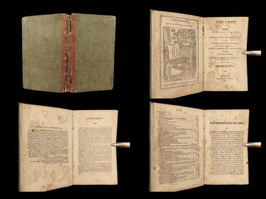
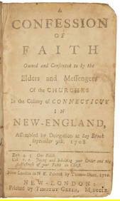
1825 SALEM WITCHCRAFT Blue Laws of 1650 Connecticut Colonial Witch Trials New HavenSchilb Antiquarian Rare Books4.8(421)See Sold PriceMar 31, 2024
D'Entrecasteaux - Map of Australia (New Holland), New Zealand, and southern Asia and surroundingTrillium Antique Prints & Rare Books4.5(30)See Sold PriceFeb 24, 2024
Arrowsmith & Lewis - Map of PolynesiaTrillium Antique Prints & Rare Books4.5(30)See Sold PriceFeb 24, 2024
Arrowsmith & Lewis - Map of North AmericaTrillium Antique Prints & Rare Books4.5(30)See Sold PriceFeb 24, 2024
Arrowsmith & Lewis - Map of the World on Mercator's ProjectionTrillium Antique Prints & Rare Books4.5(30)See Sold PriceFeb 24, 2024
Arrowsmith & Lewis - Map of LouisianaTrillium Antique Prints & Rare Books4.5(30)See Sold PriceFeb 24, 2024
Arrowsmith & Lewis - Map of the United StatesTrillium Antique Prints & Rare Books4.5(30)See Sold PriceFeb 24, 2024
Map: A 19thC engraved and hand coloured map of Buckingham titled A New Map of BuckinghamshireClaydon Auctioneers Ltd4.3(125)See Sold PriceFeb 26, 2024
Fielding (Henry) The Works, with An Essay on His Life and Genius by Arthur Murphy, 10 vol., newForum Auctions4.3(52)See Sold PriceFeb 29, 2024
9 Note Cards From the 1580's John White Drawings of the "New World"GCB Estate Sales4.5(86)See Sold PriceMar 02, 2024
Guthrie, William 1812 Antique Map. Spain and PortugalAlbion Auctions4.6(336)See Sold PriceMar 01, 2024


![[Morison (Rev. John)] Australia as it is (1 of 1)](https://p1.liveauctioneers.com/410/10729/2560460_1_x.jpg?height=282&quality=70)