ATLAS of ANTIENT GEOGRAPHY by SAMUEL BUTLER 1843John McInnis Auctioneers,LLC4.5(505)See Sold PriceFeb 24, 2024
18TH C. ANTIQUE MAP: FRENCH & INDIAN WAR, FRAMEDThomaston Place Auction Galleries4.4(393)See Sold PriceFeb 24, 2024
Rand McNally Railroad Map Cabinet w/ 21 Railroad MapsRail & Road Auctions4.6(165)See Sold PriceMar 08, 2024
Keith Haring - Ink on New York Map, Best Buddies, Inscribed, Signed, and DatedSapphire Auction Gallery4.1(67)See Sold PriceMar 02, 2024
LATE 17TH C. FRENCH MAP OF THE NEW WORLD BY ALEXIS-HUBERT JAILLOT (1632-1712)Thomaston Place Auction Galleries4.4(393)See Sold PriceFeb 24, 2024
Central Railroad of New Jersey Map of Sandy Hook Route-ca. 1903JM Hobby Supply and Railroad Artifact Auctions4.4(127)See Sold PriceFeb 24, 2024
Lot of Six Mixed Atlas Box Cars-HO Scale-New in BoxJM Hobby Supply and Railroad Artifact Auctions4.4(127)See Sold PriceFeb 25, 2024
Rand McNally/Santa Fe Railroad Map of Iowa-1912JM Hobby Supply and Railroad Artifact Auctions4.4(127)See Sold PriceFeb 24, 2024
NICOLAES VISSCHER (NETHERLANDS, 1618-1709) MAP OF THE NEW WORLDThomaston Place Auction Galleries4.4(393)See Sold PriceFeb 24, 2024
17TH C. WORLD MAP BY NICOLAES VISSCHER (NETHERLANDS, 1618-1709)Thomaston Place Auction Galleries4.4(393)See Sold PriceFeb 24, 2024
Lot of Six Mixed Atlas Cabooses-HO Scale-New in BoxJM Hobby Supply and Railroad Artifact Auctions4.4(127)See Sold PriceFeb 25, 2024
John Andrews and Andrew Drury, map of Enford,John Andrews and Andrew Drury, map of Enford, Wiltshire, circa 1810, 48cm x 65cm, framedSee Sold Price
London.- Andrews (John) and Andrew Dury. - A Map of theand Andrew Dury. A Map of the Country Sixty Five Miles Round London from Actual Surveys, 19 of 20 double-page sheets, lacking sheet 12 due west of London, with large oval title on sheet 1, dedicationSee Sold Price
SoldAndrews & Dury. A Map of the County of KentAndrews (John) and Andrew Dury A Map of the County of Kent,index map, only, for the 25-sheet map of Kent, engraved map with original hand-colouring in outline, 515 x 725mm., central vertical fSee Sold Price
SoldAndrews (John)Andrews (John) and Andrew Dury. A Map of the Country Sixty Five Miles Round London from Actual Surveys, engraved map on 20 double-page sheets with large oval title on sheet 1, dedication ovalSee Sold Price
Andrews (John) and Andrew Dury. A New Travelling MAndrews (John) and Andrew Dury. A New Travelling Map of the Country Round LondonExtending from the North to South 190 Miles and East to West 150 Miles, engraved map with hand-colouring, 1010 xSee Sold Price
SoldHERTFORDSHIRE. DURY, ANDREW & JOHN ANDREWSHertfordshire. Dury, Andrew and John Andrews. A Topographical Map of Hartford-Shire, from an Actual Survey, folding dissected map backed on to linen, on 36 sheets, a few manuscript marks, offsetting,See Sold Price
SoldSussex.- South Coast.- Andrews (John) and Andrew Dury.Sussex.- South Coast.- Andrews (John) and Andrew Dury. Two sheets from 'A Map of the Country Sixty Five Miles Round London', sheet 18 and 19, showing from Little Hampton to Rye, including Brighton, LeSee Sold Price
SoldKent.- Andrews (John Andrew Dury and W. Herbert) - A25-sheet map, with index map and plan of Canterbury in addition, 27 sheet double-page engraved map sheets, unjoined, many with original hand-colouring in outline, occasional slight browning, generallySee Sold Price
Andrews (John Andrew Dury and William Herbert - A25-sheet map, with index map and plan of Canterbury in addition, 27 sheet double-page engraved map sheets, unjoined, many with original hand-colouring in outline, occasional slight browning, generallySee Sold Price
SoldAndrew Dury and John Andrews, 'A Topographical Map ofAndrew Dury and John Andrews, 'A Topographical Map of Hartford-shire From An Actual Survey...', hand coloured engraving, published 1766, mounted over margins, 52 x 69cm; and: Robert Morden, 'ShropshirSee Sold Price
SoldKent.- Andrews (John) and Andrew Dury. After - Afacsimile 25 double-sheet county map, with index sheet, maroon cloth mounted with publisher's paper label, folio (515 x 405mm.), Lympne Castle, Kent, Harry Margary, 1968.See Sold Price
London.- Andrews (John) Andrews's Accurate Map of theLondon.- Andrews (John) Andrews's Accurate Map of the Country, Twenty-Five Miles Round London, showing north west of central London, from Windsor to Rochford in the east, and from Sevenoak up to Ware,See Sold Price
Andrews (John) Andrews's New and Accurate Map of tAndrews (John) Andrews's New and Accurate Map of the Country Thirty Miles Round London,from Stevenage to East Grinstead, and from Great Marlow to Canvey Island, title panel above, engraved mapSee Sold Price
SoldAndrews (John) Andrews's New and Accurate Map of tAndrews (John) Andrews's New and Accurate Map of the Country Thirty Miles Round London,from Stevenage to East Grinstead, and from Canvey Island to Great Marlow, title panel above, engraved mapSee Sold Price
SoldIsle of Wight.- Andrews (John) - A Topographical Map ofhand colouring, sectioned onto linen with a cloth edging, inset subscribers list and plan of Newport, slip case, rubbed, 960 x 1230mm, [c.1775].See Sold Price
London.- Andrews (John) A New Travelling Map of theLondon.- Andrews (John) A New Travelling Map of the Country Round London Extending from the North to South 190 Miles and East to West 150 Miles, engraved map with hand-colouring, 1010 x 1230 mm (43 1/See Sold Price
SoldWW2 MEM-O-MAP OKINAWA 1945WW2 MEM-O-MAP OKINAWA 1945 by John Drury- Measures 15x12_x000D_See Sold Price
Druru Map of Eastern Europe and TurkeyDRURY, Andrew (Late 18th Century).Map of the present seat of war between the Russians, Poles and Turks...Engraved map with original hand color in outline on four sheets.London, c. 1770-1790.35 1/2" xSee Sold Price
Sold(2 re: Maps of the American Revolution) History o(2 re: Maps of the American Revolution) History of the War with America, France, Spain, and Holland; Commencing in 1775 and Ending 1783. Volume IV. By John Andrews. London, 1786. 1st ed. 4 maps and 9See Sold Price
Andrews (John) A New and Accurate Map of the CountAndrews (John) A New and Accurate Map of the Country Twenty-Five Miles Round London,from Welwyn to East Grinstead, and from Windsor Great Park to Sheerness, title panel above, engraved map witSee Sold Price
SoldAndrews (John) A New and Accurate Map of the CountAndrews (John) A New and Accurate Map of the Country Twenty-Five Miles Round London,from Welwyn to Tunbridge Wells, and from Rochford to Windsor, engraved map with original hand-colouring in oSee Sold Price
Andrews (John) - Andrews's New and Accurate Map of thesheet 7 only (of 20), showing north west of central London, from Amersham to Waltham Abbey in the east, and from Twyford up to Beachwood Park, engraving with hand-colouring, 520 x 700mm., central vertSee Sold Price
Sold1761 MAP OF NORTH AMERICA BY ROCQUE18th century map GENERAL MAP OF NORTH AMERICA 1754-1761 by John Rocque, London by A. Drury, 2 part map, 35.5 x 36 inches, good condition.See Sold Price
SoldLondon.- Mogg (Edward) New Map of the Country FortLondon.- Mogg (Edward) New Map of the Country Forty-Five Miles Round London,outline colouring, linen backed, original card case, worn, 970x1180mm, 1821 § Andrews (John) A New and Accurate MapSee Sold Price
John Boydell / Carlo Dolci 1768 Scarce Engraving Death of St Andrew 17" x 12"Luis Porretta Fine Arts4.3(10)See Sold PriceMar 02, 2024
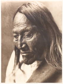
Edward S Curtis American 1868-1952 Photogravure Wedding GuestsGlobal Auctions Company4.3(36)See Sold PriceMar 03, 2024
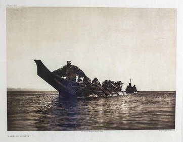
Edward S Curtis American 1868-1952 Photogravure Klickitat River PhotographGlobal Auctions Company4.3(36)See Sold PriceMar 03, 2024
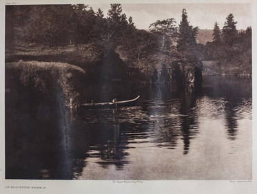
Catherwood - General View of Uxmal, Taken from the Archway of Las Monjas, Looking SouthTrillium Antique Prints & Rare Books4.5(32)See Sold PriceFeb 24, 2024
Foulis.- Dryden (John, translator).- Virgilius Maro (Publius) The Works, 3 vol., Robert & AndrewForum Auctions4.3(53)See Sold PriceFeb 29, 2024
San Xavier Del Bac Mission, Edward S. Curtis photogravurePBA Galleries4.7(385)See Sold PriceMar 07, 2024
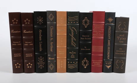
(10) limited ed books on US presidentsWilliam Bunch Auctions & Appraisals4.6(878)See Sold PriceFeb 27, 2024
John Senex Map of Louisiana & Mississippi RiverWillow Auction House4.5(289)See Sold PriceMar 14, 2024
1987 Canada Silver Dollar, 400th Anniversary of John Davis ' Exploration KM154 ProofAndrew's Coin & Jewelry4.5(209)See Sold PriceMar 07, 2024
1964 Hard Cover Used John F. Kennedy Half Dollar Collection Starting 1964 Whitman Folder # 9699 BookAndrew's Coin & Jewelry4.5(209)See Sold PriceMar 07, 2024
CAPTAIN FANTASTIC & BROWN DIRT COWBOY ELTON JOHN 1975 MCA-2142 W/INSERTS/POSTERAndrew's Coin & Jewelry4.5(209)See Sold PriceMar 07, 2024
Elton John - Rock Of The Westies-LP- MCA-2163 1st 1975 USAAndrew's Coin & Jewelry4.5(209)See Sold PriceMar 07, 2024
Mighty Marvel Must Haves (2002) - #2 - "Amazing Spider-Man #36, Incredible Hulk #34, Daredevil #26,Andrew's Coin & Jewelry4.5(209)See Sold PriceMar 07, 2024
The Amazing Spider-Man #432 (Vol. 1) [Comic] Tom DeFalco; John Romita Jr. and Bud LaRosaAndrew's Coin & Jewelry4.5(209)See Sold PriceMar 07, 2024


![Ice On Fire [Vinyl] Elton John (1 of 1)](https://p1.liveauctioneers.com/2742/320466/172198302_1_x.jpg?height=282&quality=70&version=1708642023)


![The Amazing Spider-Man #432 (Vol. 1) [Comic] Tom DeFalco; John Romita Jr. and Bud LaRosa (1 of 1)](https://p1.liveauctioneers.com/2742/320466/172198550_1_x.jpg?height=282&quality=70&version=1708642023)