1952 ROBERT F. KENNEDY HANDWRITTEN LETTERJohn McInnis Auctioneers,LLC4.5(505)See Sold PriceFeb 25, 2024
CASED PRESENTATION HALF HULL MODEL OF THE BARQUE "HAWTHORNBANK" Last Quarter of the 19th CenturyEldred's4.7(419)See Sold PriceFeb 27, 2024
Lot Of 14 Jack Daniels And Country Club Glass Spirit BottlesRbfinearts4.5(578)See Sold PriceFeb 24, 2024
PR OF 17TH C. SPANISH BRASS CANDLESTICKSThomaston Place Auction Galleries4.4(393)See Sold PriceFeb 24, 2024
Lake Shore and Michigan Southern RR Special Excursions Timetable-July 7-13, 1892JM Hobby Supply and Railroad Artifact Auctions4.4(127)See Sold PriceFeb 24, 2024
Tiffany & Co. Sterling Silver Corkscrew Bottle OpenerSJ Auctioneers4.5(167)See Sold PriceMar 03, 2024
Johann Matthias Hasii (1684-1742) Engraved map ofJohann Matthias Hasii (1684-1742) Engraved map of Russia with a portrait of the Empress Anna Ioanovna in cartouch Engraving, etching, watercolour First half of XVIII c The workshop of the followers ofSee Sold Price
SoldAfricaJohann Matthias Hase (1684-1742). engraved map with original hand-color in full. Nuremberg, c. 1740. 21 x 24 inches, 32 1/2 x 35 1/2 inches framed. Map of Africa by the first cartographer to use a sciSee Sold Price
SoldCarte De l'AsieJohann Matthias Hasius (1684-1742). Leipzig, 1774. Engraved map with original hand color in part. 24 x 21 inches sheet, 32 1/2 x 35 1/2 inches framed. Stunning Color Map of Asia by HasiusSee Sold Price
Haas Map of Europe, 1743HAAS, Johann Matthias (1684-1742). Europa Secundum Legitimas Projectionis Stereographicae Regulas et juxta recentissimas observationes... Engraved map with original hand color in part. Nuremburg: HommSee Sold Price
SoldMap, Johann Matthias Haase/ Homann Heirs, ImperiiJohann Matthias Haase (German, 1684-1742)/ Homann Heirs, "Imperii Russici et Tatariae Universae tam majoris et Asiaticae quam minoris et Europae Tabula..." 1739, hand-colored copper engraved map, sheeSee Sold Price
Johann Matthias Haas (German, 1684-1742) - Map of theJohann Matthias Haas (Germany, 1684-1742) - Map of the Kingdoms of David and Solomon, Nuremberg, 1739. Regni Davidici et Salomonaei Descriptio Geographica cum Vicinis regionibus Syriae et Aegypti. ColSee Sold Price
Hasius Map of AsiaCarte de L'Asie projectee stereographiquement tiree des relations et observations... Johann Matthais Hasius (1684-1742). Engraved map with hand color. Nurnberg, 1744. 24 x 21 inches sheet, 32 1/2 x 35See Sold Price
SoldHomann Heirs Americas MapHomann Heirs and Johann Matthuas Haas (1684-1742).? Americae Mappa generalis... Engraved map with orignal hand color. Nuremburg: 1764. 21 1/4" x 24 1/4" sheet, 33" x 36" framed. This is a handsome, deSee Sold Price
Homann Heirs: Antique Map of Great Tartary, 1739Map: Tartariae. Maioris five Asiaticae tabvla Publication Date: 1739 Cartographer: Johann Matthias Haas (1684-1742) Publisher: Homann heirs 1739 Nuremberg Size: Double Folio – 18.75 H x 21.5 W IncheSee Sold Price
SoldAN ANTIQUE MAP, "Americæ Mappa Generalis," 1746,AN ANTIQUE MAP, "Americæ Mappa Generalis," 1746, hand colored engraving, published by Johann Baptist Homann (1664-1724) with special acknowledgement to Johann Matthias Hase (1684-1742) and AugustSee Sold Price
SoldAN ANTIQUE MAP, "Americæ Mappa Generalis," 1746,AN ANTIQUE MAP, "Americæ Mappa Generalis," 1746, hand colored engraving, published by Johann Baptist Homann (1664-1724) with special acknowledgement to Johann Matthias Hase (1684-1742) and AugustSee Sold Price
SoldTartariae. Maioris five Asiaticae tabvlaTitle/Content of Map: Tartariae. Maioris five Asiaticae tabvla Cartographer: Johann Matthias Haas (1684-1742) Height (inches): 18.75 Width (inches): 21.5Year: 1739 quae praesertim complectit TartariamSee Sold Price
SoldHaas & Heirs, map of AfricaHaas & Heirs, map of Africa, Johann Matthias Haas (German, 1684-1742), "Leonis Africani", 1737, 21"h x 25.25"w (sheet), unframed Provenance: Property from a major corporate art collection, NYSee Sold Price
SoldTWO EARLY MAPS. Map of Africa by Johann Matthias HTWO EARLY MAPS. Map of Africa by Johann Matthias Hase (German, 1684-1742), engraving on laid paper with handcoloring, 18th Century, 24"h. 27"w. (framed); and a map of Greece and Crete by Guillaume DelSee Sold Price
JOHANN MATTHIAS HASE ENGRAVING MAP AFRICA, 18TH C.Unframed map, engraving on paper, "'Africa Secundum Legitimas Projectionis Stereographicae regulas," Johann Matthias Hase (German, 1684-1742), cartouche with title in lower left corner, illustrated wiSee Sold Price
Hasas Europe Lithuanian Polish[1743 Map of Europe with the Lithuanian-Polish State in it] Creator Johanas Matias Hasas (Johann Matthias Haas; Hassius Hase Hasio Haase) 1684-1742). Cartoon entry: "Europa Secundum legitimas ProjectiSee Sold Price
SoldJohann Matthias Hase Homann Heirs World MapJohann Mathias Hase (1684-1742), "Planiglobii Terrestris Mappa Universalis: Utrumque Hemisphaerium Orient. et Occidentale Repraesentans," Nuremberg: Homann Heirs, 1746. Hand colored map of the world iSee Sold Price
SoldJohann Matthias Haas, ''Hungariae...,'' [Ca. 1740[Hungary/Balkans]. Johann Matthias Hass. Hungariae Ampliori Signific Atu Et Veteris.../ Carte d'Hongrie... Double-page engraved map of most of the Balkan Peninsula, with Latin title in cartouche at loSee Sold Price
Johann Matthias Haas "Landkarte "Asia secundum(1684 - 1742) grenzkolorierte Kupferstichkarte/Papier unten links in der Platte bezeichnet datiert 1744 große und hochfein illustrierte Karte des asiatischen Kontinents und der südSee Sold Price
SoldEurasia. Homann Heirs, 1744.[Asia]. Homann Heirs. Asia Secundum Legitimas Projectionis Stereographicae Regulas et Juxta Recentissimas Observation... Double-page engraved map A.G. Boehme after a map drawn by Johann Matthias Haas.See Sold Price
Antique Colored Map - Europe - Balkans - Hungary - Romania - Bulgaria - HeirsOriginally colored engraved map of the Balkans by Johann Matthias Hase printed by Homann Heirs. Shows Hungary, Romania, Bulgaria, the former Yugoslavia (Croatia, Serbia, Bosnia, Macedonia), Albania anSee Sold Price
SoldHomann map, Imperii Russici et Tartariae, 1739[Russia & Asia]. Johann Matthias Haas. Imperii Russici Et Tatariae Universal Tam Majoris Et Asiaticae, Quam Minoris Et Europaeae Tabula.... Double-page map engraved by K.A. Schneider, revision of an eSee Sold Price
SoldHomman Map of the AmericasHOMANN, Johann Baptist (1664-1724).Totius Americae Septentrionalis et Meridionalis Novissima Repraesentatio.Engraved map with hand color in full.Nuremberg: Homann, c. 1742.20 3/4" x 23 5/8" sheet. HomSee Sold Price
SoldMatthiae Hasii (1684-1742, Homann Heirs), "EuropaMatthiae Hasii (1684-1742, Homann Heirs), "Europa Secundum," 1743, hand colored, H. - 20 3/8 in., W. - 24 1/8 in.See Sold Price
17th Century Hand Colored Engraved Map of GermanyGlobal Auctions Company4.3(36)See Sold PriceMar 03, 2024
18th Century Hess Germany Hand colored Engraved MapGlobal Auctions Company4.3(36)See Sold PriceMar 03, 2024
[MAP]. NICHOLLS, Sutton (1668-1729). An Epitome of Sr. Will...Potter & Potter Auctions4.6(545)See Sold PriceMar 07, 2024
Arrowsmith & Lewis - Map of the United StatesTrillium Antique Prints & Rare Books4.5(32)See Sold PriceFeb 24, 2024
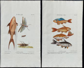
Edwards & Seligmann - 3 Fish EngravingsTrillium Antique Prints & Rare Books4.5(32)See Sold PriceFeb 24, 2024
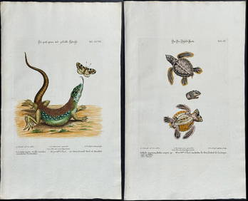
Edwards & Seligmann - 5 Engravings of Lizards, Snake, & Sea TurtleTrillium Antique Prints & Rare Books4.5(32)See Sold PriceFeb 24, 2024
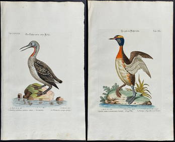
Edwards & Seligmann - Pair of Diver or Loon EngravingsTrillium Antique Prints & Rare Books4.5(32)See Sold PriceFeb 24, 2024
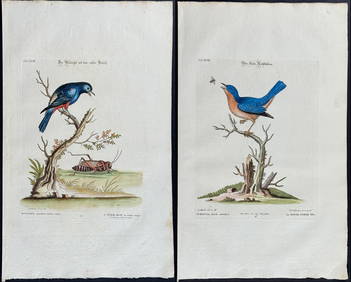
Edwards & Seligmann - 4 Bird EngravingsTrillium Antique Prints & Rare Books4.5(32)See Sold PriceFeb 24, 2024
Churchill & Nieuhof 1744 Folio Map. Batavia Indonesia East IndiesAlbion Auctions4.7(341)See Sold PriceMar 01, 2024
Cooke, George 1801 Antique Map. United States of AmericaAlbion Auctions4.7(341)See Sold PriceMar 01, 2024
Herman Moll A New Map of Ye North Parts of AmericaWillow Auction House4.5(289)See Sold PriceMar 14, 2024


![[MAP]. NICHOLLS, Sutton (1668-1729). An Epitome of Sr. Will... (1 of 1)](https://p1.liveauctioneers.com/928/318880/171361281_1_x.jpg?height=282&quality=70&version=1707501302)