ATLAS of ANTIENT GEOGRAPHY by SAMUEL BUTLER 1843John McInnis Auctioneers,LLC4.6(502)See Sold PriceFeb 24, 2024
18TH C. ANTIQUE MAP: FRENCH & INDIAN WAR, FRAMEDThomaston Place Auction Galleries4.4(386)See Sold PriceFeb 24, 2024
Rand McNally Railroad Map Cabinet w/ 21 Railroad MapsRail & Road Auctions4.6(165)See Sold PriceMar 08, 2024
Keith Haring - Ink on New York Map, Best Buddies, Inscribed, Signed, and DatedSapphire Auction Gallery4(67)See Sold PriceMar 02, 2024
LATE 17TH C. FRENCH MAP OF THE NEW WORLD BY ALEXIS-HUBERT JAILLOT (1632-1712)Thomaston Place Auction Galleries4.4(386)See Sold PriceFeb 24, 2024
Central Railroad of New Jersey Map of Sandy Hook Route-ca. 1903JM Hobby Supply and Railroad Artifact Auctions4.4(126)See Sold PriceFeb 24, 2024
Lot of Six Mixed Atlas Box Cars-HO Scale-New in BoxJM Hobby Supply and Railroad Artifact Auctions4.4(126)See Sold PriceFeb 25, 2024
Rand McNally/Santa Fe Railroad Map of Iowa-1912JM Hobby Supply and Railroad Artifact Auctions4.4(126)See Sold PriceFeb 24, 2024
NICOLAES VISSCHER (NETHERLANDS, 1618-1709) MAP OF THE NEW WORLDThomaston Place Auction Galleries4.4(386)See Sold PriceFeb 24, 2024
17TH C. WORLD MAP BY NICOLAES VISSCHER (NETHERLANDS, 1618-1709)Thomaston Place Auction Galleries4.4(386)See Sold PriceFeb 24, 2024
Lot of Six Mixed Atlas Cabooses-HO Scale-New in BoxJM Hobby Supply and Railroad Artifact Auctions4.4(126)See Sold PriceFeb 25, 2024
SoldJohann B. Homann (Ger., 1664-1724) Pair of MapsJohann Baptist Homann (German, 1664-1724). Pair of hand-colored map engravings. Date of original publication: 1715. "Totius Africae Nova Repraesentatio." 20 1/4 x 23 3/4 inches. "Totius Regn sive GallSee Sold Price
SoldJohann B Homann (Ger, 1664-1724) Pair of MapsJohann Baptist Homann (German, 1664-1724). Pair of hand-colored map engravings. Date of original publication: 1715. "Totius Africae Nova Repraesentatio." 20 1/4 x 23 3/4 inches. "Totius Regn sive GallSee Sold Price
Johann B Homann (Ger, 1664-1724) Pair of MapsJohann Baptist Homann (German, 1664-1724). Pair of hand-colored map engravings. Date of original publication: 1715. "Totius Africae Nova Repraesentatio." 20 1/4 x 23 3/4 inches. "Totius Regn sive GallSee Sold Price
Johann B Homann (Ger, 1664-1724) Pair of MapsJohann Baptist Homann (German, 1664-1724). Pair of hand-colored map engravings. Date of original publication: 1715. "Totius Africae Nova Repraesentatio." 20 1/4 x 23 3/4 inches. "Totius Regn sive GallSee Sold Price
Johann B Homann (Ger, 1664-1724) Pair of MapsJohann Baptist Homann (German, 1664-1724) Pair of hand-colored map engravings Date of original publication: 1715 "Totius Africae Nova Repraesentatio" 20 1/4 x 23 3/4 inches "Totius Regn sive Galliae FSee Sold Price
Johann B Homann (Ger, 1664-1724) Pair of MapsJohann Baptist Homann (German, 1664-1724) Pair of hand-colored map engravings Date of original publication: 1715 "Totius Africae Nova Repraesentatio" 20 1/4 x 23 3/4 inches "Totius Regn sive Galliae FSee Sold Price
SoldMap, "Cataloniae" Johann Baptist Homann, c.1720Johann Baptist Homann (German, b.1664-1724). 1720 map of Catalonia region of Spain by cartographer Johann Baptist Homann. Place / Date: Nuremberg, c.1720. Antiquarian Map, "Principatus Cataloniae necSee Sold Price
Striking portrait of Johann Baptiste Homann. From hisTitle: Striking portrait of Johann Baptiste Homann. From his atlas by Homann heirs 1762 Date/Period: 1762 Materials: Copper plate engraved Size: 20 x 12 1/2”. J. B. Homann (1664-1724) was a self tauSee Sold Price
Striking portrait of Johann Baptiste Homann. From hisTitle: Striking portrait of Johann Baptiste Homann. From his atlas by Homann heirs 1762 Date/Period: 1762 Materials: Copper plate engraved Size: 20 x 12 1/2”. J. B. Homann (1664-1724) was a self tauSee Sold Price
Striking portrait of Johann Baptiste Homann. From hisTitle: Striking portrait of Johann Baptiste Homann. From his atlas by Homann heirs 1762 Date/Period: 1762 Materials: Copper plate engraved Size: 20 x 12 1/2”. J. B. Homann (1664-1724) was a self tauSee Sold Price
Striking portrait of Johann Baptiste Homann. From hisTitle: Striking portrait of Johann Baptiste Homann. From his atlas by Homann heirs 1762 Date/Period: 1762 Materials: Copper plate engraved Size: 20 x 12 1/2”. Description: J. B. Homann (1664-1724) wSee Sold Price
SoldPair of late 17th/early 18th Century Maps-Denmark andPair of late 17th/early 18th century maps including; 1.) Framed map titled "Tabula Generalis Iutiae" by Johann Baptist Homann (1664-1724). This hand-colored map of Denmark was published in 1710 and meSee Sold Price
Homann, Johann B. Archiducatus Austriae InferiorisHomann, Johann Baptist Archiducatus Austriae Inferioris É C. 1720 Copperplate engraving; area coloured Printed area: 58.6 x 48.6 cm; 23 x 19 in This map by Johann Baptist Hohmann (1664-1724) shows thSee Sold Price
SoldJohann Baptista Homann, (German, 1664-1724), MapJohann Baptista Homann (German, 1664-1724) Map of Wurtzenburg, Germany hand colored engraving 18 1/4 x 22 inches. Property from the Estate of Marcia B. Nachtrieb.See Sold Price
SoldJ. B. HOMMAN 1733 MAP OF HOLLANDHOMANN, Johann Baptist, (German, 1664-1724): Map after Homann, circa 1733, Nuremburg, "Tabula Comitatus Hollandiae", partially hand colored engraving. Cartouche upper left. Plate size 23 1/4" x 19 3/4See Sold Price
TOTIUS AMERICAE SEPTENTRIONALIS ET MERIDIONALIS MAP BYTOTIUS AMERICAE SEPTENTRIONALIS ET MERIDIONALIS MAP BY J. B. HOMANN, CIRCA 1737. 20" x 23" NOTE: Johann Baptist Homann (March 20, 1664 - July 1, 1724) was the most prominent and prolific map publisherSee Sold Price
"TOTIUS AMERICAE SEPTENTRIONALIS ET MERIDIONALIS" MAP"TOTIUS AMERICAE SEPTENTRIONALIS ET MERIDIONALIS" MAP BY J. B. HOMANN, CIRCA 1737. 20" x 23" Note: Johann Baptist Homann (March 20, 1664 - July 1, 1724) was the most prominent and prolific map publishSee Sold Price
"TOTIUS AMERICAE SEPTENTRIONALIS ET MERIDIONALIS" MAP"TOTIUS AMERICAE SEPTENTRIONALIS ET MERIDIONALIS" MAP BY J. B. HOMANN, CIRCA 1737. 20" x 23" NOTE: Johann Baptist Homann (March 20, 1664 - July 1, 1724) was the most prominent and prolific map publishSee Sold Price
SoldTOTIUS AMERICAE SEPTENTRIONALIS ET MERIDIONALIS MAP BYTOTIUS AMERICAE SEPTENTRIONALIS ET MERIDIONALIS MAP BY J. B. HOMANN, CIRCA 1737. 20" x 23". Framed. NOTE: Johann Baptist Homann (March 20, 1664 - July 1, 1724) was the most prominent and prolific mapSee Sold Price
TOTIUS AMERICAE SEPTENTRIONALIS ET MERIDIONALIS MAP BYTOTIUS AMERICAE SEPTENTRIONALIS ET MERIDIONALIS MAP BY J. B. HOMANN, CIRCA 1737, 20" x 23". Framed.NOTE: Johann Baptist Homann (March 20, 1664 - July 1, 1724) was the most prominent and prolific map pSee Sold Price
TOTIUS AMERICAE SEPTENTRIONALIS ET MERIDIONALIS MAP BYTOTIUS AMERICAE SEPTENTRIONALIS ET MERIDIONALIS MAP BY J. B. HOMANN, CIRCA 1737, 20" x 23". NOTE: Johann Baptist Homann (March 20, 1664 - July 1, 1724) was the most prominent and prolific map publisheSee Sold Price
TOTIUS AMERICAE SEPTENTRIONALIS ET MERIDIONALIS MAP BYTOTIUS AMERICAE SEPTENTRIONALIS ET MERIDIONALIS MAP BY J. B. HOMANN, CIRCA 1737, 20" x 23". Framed.NOTE: Johann Baptist Homann (March 20, 1664 - July 1, 1724) was the most prominent and prolific map pSee Sold Price
TOTIUS AMERICAE SEPTENTRIONALIS ET MERIDIONALIS MAP BYTOTIUS AMERICAE SEPTENTRIONALIS ET MERIDIONALIS MAP BY J. B. HOMANN, CIRCA 1737, 20" x 23". Framed.NOTE: Johann Baptist Homann (March 20, 1664 - July 1, 1724) was the most prominent and prolific map pSee Sold Price
TOTIUS AMERICAE SEPTENTRIONALIS ET MERIDIONALIS MAP BYTOTIUS AMERICAE SEPTENTRIONALIS ET MERIDIONALIS MAP BY J. B. HOMANN, CIRCA 1737. 20" x 23" NOTE: Johann Baptist Homann (March 20, 1664 - July 1, 1724) was the most prominent and prolific map publisherSee Sold Price
PAIR OF WORLD WAR II JAPANESE NAVAL BINOCULARS CAPTURED BY H.M.S. "EURYALUS" 1943-1945 Case heightEldred's4.7(409)See Sold PriceFeb 27, 2024
1876 The Centennial Exhibition Pennsylvania Railroad Worlds Fair Guide with Map and Trade CardRail & Road Auctions4.6(165)See Sold PriceMar 07, 2024
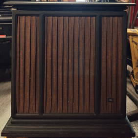
Pair of Vintage JBL C61 Sovereign II Cabinet SpeakersHeritage Gallery Auctions4.4(56)See Sold PriceMar 10, 2024
LEUNG KUI-TING (CHINESE B. 1945) INK AND COLOR ON PAPERSoulis Auctions4.8(953)See Sold PriceFeb 24, 2024
Pair KAWS (Brian Donnelly (b. 1974)) Companion Vinyl FiguresHughes Auctions4.4(165)See Sold PriceFeb 25, 2024
Johann Homann Hand-Colored Map Engraving, c. 1730Auctions at Showplace4.5(726)See Sold PriceMar 17, 2024
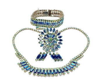
FINE JEWELRY LOT BY B. DAVID 4 SIGNED PIECES NECKLACE BRACELET BROOCH EARRINGS RHINESTONENoble House Collection Gallery4.5(114)See Sold PriceFeb 28, 2024
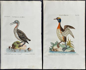
Edwards & Seligmann - Pair of Diver or Loon EngravingsTrillium Antique Prints & Rare Books4.5(30)See Sold PriceFeb 24, 2024
Audubon, NYSE Best Watercolor Ed - Pair: Brown Pelican & Reddish EgretTrillium Antique Prints & Rare Books4.5(30)See Sold PriceFeb 24, 2024
1736 LARGE MAP OF SILESIA POLAND OPPAVIENSIS antique 25 by 34 3/4"Jasper524.5(9.8k)See Sold PriceFeb 27, 2024
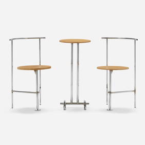
Shiro Kuramata, Three-legged B chairs, pair and tableLos Angeles Modern Auctions4.4(24)See Sold PriceFeb 28, 2024
Extensive Paris Porcelain Lavender Ground Porcelain Part Service with Monogram 'B'STAIR4.6(286)See Sold PriceMar 06, 2024
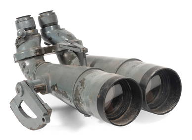
GREEN WING TEAL PAIR, B. WHITEFrank and Frank Sporting Collectibles LLC4.7(166)See Sold PriceMar 10, 2024
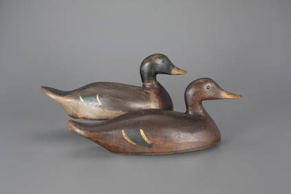
ONE-THIRD SIZE RED-BREASTED MERGANSER PAIR, B. SEABROOKFrank and Frank Sporting Collectibles LLC4.7(166)See Sold PriceMar 10, 2024