SoldJoan Blaeu (1596 - 1673), by and after, a two-page map,Joan Blaeu (1596 - 1673), by and after, a two-page map, Darbiensis Comitatvs, Vernacul Darbie Shire (sic, Derbyshire), proto-Baroque cartouche and allegory to lower-left margin, two pages of Latin topSee Sold Price
SoldAfter Joan Blaeu (1596-1673), Coloured map ofAfter Joan Blaeu (1596-1673), Coloured map of Gloucestershire, Glocestria Decatus VulgoGlocester. The upper left corner with twelve shields, ten featuring family coats of arms and two blank. A decoratSee Sold Price
SoldJoan Blaeu Map ca. 1690 "Aethiopia Superior vel IJoan Blaeu (1596-1673). Map of central Africa, "Aethiopia superior vel interior, vulgo Abissinorum sive Presbiteri Ioannis imperium." Initially from Blaeu's "Atlas Major." 1635. Dimensions: Sheet; heiSee Sold Price
SoldBlaeu Map of BrazilMaritima Brasiliae Universa. Joan Blaeu (1596-1673). Engraved map with original color in part. Amsterdam: Blaeu, 1647. 21 x 24 1/2 inches sheet, 32 1/2 x 36 inches framed. This separately issued and rSee Sold Price
SoldJOAN BLAEU (DUTCH, 1596-1673) MAP OF THE VOLGA RIVERJOAN BLAEU (DUTCH, 1596-1673) MAP OF THE VOLGA RIVER, hand-colored, on laid paper, retaining bold likely original colors, based after the travels of Adamo Oleario, cartouche depicting reindeers. UnfraSee Sold Price
SoldBlaeu, Map of the BalkansIllyricum Hodiernum Quod Scriptores...Joan Blaeu (1596-1673). Engraved map with original hand color. Amsterdam, c. 1680.See Sold Price
SoldFirst Dutch map to focus on the Lesser AntillesCanibales Insulae... Joan Blaeu (1596-1673). Engraved map with original hand color in outline. Amsterdam, 1662.. 20 1/2 x 24 inches sheet, 30 x 33 1/2 inches framed. This is the first Dutch chart to fSee Sold Price
Engraved Map of Northumbria by BlaeuComitatus Northvmbria Vernacule Northumberland. Joan Blaeu (1596-1673). Engraved map with original hand color in outline. Amsterdam, c. 1647. 20 x 23 3/4 inches sheet. Title banderole supported by putSee Sold Price
Sold(Europe), Blaeu, Willem (1571-1638) and Blaeu, Jan(Europe), Blaeu, Willem (1571-1638) and Blaeu, Jan (1596-1673), six double-page folding maps, Amsterdam, c. 1630-1640, all uncolored, mostly regions of Germany and one of Macedonia, folio, (scatteredSee Sold Price
Original Timothy Pont, Blaeu, Joannes Atlas of ScotlandLidalia vel Lidisdalia regio, Lidisdail / Auct. Timotheo Pont. By: Pont, Timothy, 1560-1614? Blaeu, Joan, 1596-1673. This beautifully engraved map covers the Liddell River valley on the border of ScotSee Sold Price
Sold17th Century Map of Evian France-BlaeuCopper plate engraved map by Joan Blaeu (1596-1673) being a birds eye view of the town of Evian-les-Bains, in the French of department Haute-Savoie. Map measures 17.5" x 22" and is housed in a frame mSee Sold Price
Joan Blaeu Engraved Map from the Atlas of Scotland - Caithness region NE ScotlandBLAEU, Joan (1596-1673). Cathenesia / Caithness. Engraved map with original hand color. Amsterdam: Joan Blaeu, 1654-1662. [Dutch Text on verso]. 20 1/8" x 24 5/8" sheet. In 1654 Joan Blaeu applied forSee Sold Price
Original Timothy Pont, Blaeu, Joannes Atlas of ScotlandLidalia vel Lidisdalia regio, Lidisdail / Auct. Timotheo Pont. By: Pont, Timothy, 1560-1614? Blaeu, Joan, 1596-1673. This beautifully engraved map covers the Liddell River valley on the border of ScotSee Sold Price
Original Timothy Pont, Blaeu, Joannes Atlas of ScotlandLidalia vel Lidisdalia regio, Lidisdail / Auct. Timotheo Pont. By: Pont, Timothy, 1560-1614? Blaeu, Joan, 1596-1673. This beautifully engraved map covers the Liddell River valley on the border of ScotSee Sold Price
SoldJoan Blaeu Map of Amersfoort ca. 1650Joan Blaeu (1596-1673), "Amisfurtum," Amsterdam, ca. 1650. Hand colored map of the town of Amersfoort in the Netherlands. Dimensions: Sight; height: 16 1/4 in x width: 20 1/4 in. Framed; height: 17 3/See Sold Price
SoldWillem Blaeu (1571-1638) and Jan Blaeu (1596-1673Willem Blaeu (1571-1638) and Jan Blaeu (1596-1673) Sterlinensis Praefectura. Sterlin-Shyr, double-page engraved map hand-coloured in outline, 41.5 x 52.4cm, [Amsterdam: Blaeu, 1654], framed and glazedSee Sold Price
SoldWillem Blaeu (1571-1638) and Jan Blaeu (1596-1673Willem Blaeu (1571-1638) and Jan Blaeu (1596-1673) Strath-Navernia. Strath-Navern, double-page engraved map hand-coloured in outline, text on verso, repair to central fold and upper left corner, frameSee Sold Price
Joan Blaeu Engraved Map from the Atlas of Scotland - SoutherlandiaBLAEU, Joan (1596-1673). Southerlandia. [Southerland, Scotland]. Engraved map with original hand color. Amsterdam: Joan Blaeu, 1654-1662. [Dutch Text on verso]. 20 1/4" x 24 1/2" sheet. In 1654 Joan BSee Sold Price
Joan Blaeu Engraved Map from the Atlas of Scotland - County of Brecknock (Brecon) in WalesBLAEU, Joan (1596-1673). Comitatus Brechiniae / Breknoke. Engraved map with original hand color. Amsterdam: Joan Blaeu, 1654-1662. [Dutch Text on verso]. 20 1/8" x 24" sheet. In 1654 Joan Blaeu applieSee Sold Price
Joan Blaeu Engraved Map from the Atlas of Scotland - County of BerkshireBLAEU, Joan (1596-1673). Bercheria Vernacule Barkshire. Engraved map with original hand color. Amsterdam: Joan Blaeu, 1654-1662. [Dutch Text on verso]. 20" x 23 7/8" sheet. Windsor castle, first builtSee Sold Price
Joan Blaeu (Dutch 1596-1673)/Lincolnia Comitatus/handJoan Blaeu (Dutch 1596-1673)/Lincolnia Comitatus/hand coloured engraved map, 43cm x 51cmSee Sold Price
Sold2 Joan Blaeu Large Architectural Arc EngravingsJohannes Blaeu (Netherlandish, 1596-1673). Two Roman Arc engravings comprising of Arcus Septimii & Arcus Imperatoris Titi. On laid paper. Approx. 36.5" x 41.25" (framed), 18.625" x 23.625" (plate sideSee Sold Price
SoldJoan Blaeu (1596 - 1673) Ducatus Eboracensis parsJoan Blaeu (1596 - 1673) Ducatus Eboracensis pars Borealis, The North Riding or York Shire, color engraved map, sight size 15" x 20". Provenance: Estate of Mark W. Izard MD, Cider Brook Road, Avon, CTSee Sold Price
Blaeu Joan map Lithuania BelarusJoan Blaeu (1596-1673) MAGNI DVCATVS LITHVANIE et Regionum Adiacentium Exacta Descriptio Â… 1648, copper engraving on paper, watercolor, 45 x 52 cm, Amsterdam Dimensions (in cm): 45 x 52See Sold Price
Chicago Danville and Vincennes RR Gold Bond Prospectus Book-1872JM Hobby Supply and Railroad Artifact Auctions4.4(127)See Sold PriceFeb 24, 2024
Cleveland and Mahoning RR 2nd Annual Report-December 20, 1854JM Hobby Supply and Railroad Artifact Auctions4.4(127)See Sold PriceFeb 24, 2024
Northern Pacific RR 17th Annual Report-Version 1-September 15, 1881JM Hobby Supply and Railroad Artifact Auctions4.4(127)See Sold PriceFeb 24, 2024
Northern Pacific RR 17th Annual Report-Version 2-September 15, 1881JM Hobby Supply and Railroad Artifact Auctions4.4(127)See Sold PriceFeb 24, 2024
Chicago Milwaukee and St Paul RY To the Lakes of Wisconsin and Minnesota Book-1909JM Hobby Supply and Railroad Artifact Auctions4.4(127)See Sold PriceFeb 24, 2024
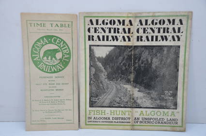
Algoma Central RY March 12, 1944 Public Timetable and BrochureJM Hobby Supply and Railroad Artifact Auctions4.4(127)See Sold PriceFeb 24, 2024
ABRAHAM ORTELIUS (1527-1598) MAP OF ROMAN GAUL (FRANCE)Thomaston Place Auction Galleries4.4(393)See Sold PriceFeb 24, 2024
WILLEM JANSZOON BLAEU (NETHERLANDS, 1571-1638) MAP OF UMBRIAThomaston Place Auction Galleries4.4(393)See Sold PriceFeb 24, 2024
Willem Blaeu, Etc. 17th C. Antiquarian Maps, 2Auctions at Showplace4.6(740)See Sold PriceMar 17, 2024
1704 DESCRIPTION OF ALL THE SEATS OF THE PRESENT WARS OF EUROPE antique w/ MAPSJasper524.5(9.9k)See Sold PriceFeb 27, 2024
SOUTHERN AFRICA.Inset Ascension Is.; European colonies 1914;St Helena 1920 mapJasper524.5(9.9k)See Sold PriceFeb 28, 2024
OLD ILLUSTRATED 1902 CROSS-COVERED LANDS JOURNEY TO CALCUTTA, INDIA, 2 VOLUMESNY Elizabeth 4.2(86)See Sold PriceMar 03, 2024
THE WHOLE CHRONICLE OF POLYBIUS ANCIENT IN ENGLISH, 1756NY Elizabeth 4.2(86)See Sold PriceMar 03, 2024
1675: ANTIQUE ILLUSTRATED JULIUS CAESAR MAPS OF ROMAN HISTORYNY Elizabeth 4.2(86)See Sold PriceMar 03, 2024