ATLAS of ANTIENT GEOGRAPHY by SAMUEL BUTLER 1843John McInnis Auctioneers,LLC4.6(502)See Sold PriceFeb 24, 2024
18TH C. ANTIQUE MAP: FRENCH & INDIAN WAR, FRAMEDThomaston Place Auction Galleries4.4(386)See Sold PriceFeb 24, 2024
Rand McNally Railroad Map Cabinet w/ 21 Railroad MapsRail & Road Auctions4.6(165)See Sold PriceMar 08, 2024
Keith Haring - Ink on New York Map, Best Buddies, Inscribed, Signed, and DatedSapphire Auction Gallery4(67)See Sold PriceMar 02, 2024
LATE 17TH C. FRENCH MAP OF THE NEW WORLD BY ALEXIS-HUBERT JAILLOT (1632-1712)Thomaston Place Auction Galleries4.4(386)See Sold PriceFeb 24, 2024
Central Railroad of New Jersey Map of Sandy Hook Route-ca. 1903JM Hobby Supply and Railroad Artifact Auctions4.4(126)See Sold PriceFeb 24, 2024
Lot of Six Mixed Atlas Box Cars-HO Scale-New in BoxJM Hobby Supply and Railroad Artifact Auctions4.4(126)See Sold PriceFeb 25, 2024
Rand McNally/Santa Fe Railroad Map of Iowa-1912JM Hobby Supply and Railroad Artifact Auctions4.4(126)See Sold PriceFeb 24, 2024
NICOLAES VISSCHER (NETHERLANDS, 1618-1709) MAP OF THE NEW WORLDThomaston Place Auction Galleries4.4(386)See Sold PriceFeb 24, 2024
17TH C. WORLD MAP BY NICOLAES VISSCHER (NETHERLANDS, 1618-1709)Thomaston Place Auction Galleries4.4(386)See Sold PriceFeb 24, 2024
Lot of Six Mixed Atlas Cabooses-HO Scale-New in BoxJM Hobby Supply and Railroad Artifact Auctions4.4(126)See Sold PriceFeb 25, 2024
Jeffreys Map of Gulf CoastJEFFERYS, Thomas (1719-1771). The Western Coast of Louisiana and the coast of New Leon. Copperplate engraving from The West India Atlas. London, 1794. 21 x 27 1/2 inches sheet, 33 x 39 inches framed FSee Sold Price
1728 Laval Map, Gulf Coast, Mississippi River - FlordiaItem: 1728 Laval Map, Gulf Coast, Mississippi River - Flordia Description: Laval Map of the Gulf Coast from the Mississippi River to Flordia Dimensions: 8.5 x 19.5 in Please note that this lot has a cSee Sold Price
SoldU S Coast Survey 1896 LG Map. Gulf Coast. Florida, MI"Sketch Showing Progress of Surveys on the Gulf Coast Lake Pontchartrain Mobile and Pensacola Bays" Detailed map showing New Orleans to Santa Rosa Sound, with inset showing Tortugas Harbor. Large LithSee Sold Price
SoldMap of Gulf Coast for US Coast SurveyMap of Gulf Coast for US Coast Survey , "U.S. Coast Survey....Section No. 8, 1845-1851", lithograph, with later hand-coloring, sight 15 1/2 in. x 22 3/4 in., framed Provenance: Estate of Julia Evans RSee Sold Price
SoldAntique Map of Gulf CoastAntique Map of Gulf Coast , "Preliminary Chart No. 26 of the Sea Coast of the United States from Mobile Bay Ala. to Lake Bogue La...", 1857, electrotype, with later hand-coloring, sheet 21 in. x 42 1/See Sold Price
SoldMap of Gulf Coast, 1861, by Pessou & Simon, N.O."Hydrographical & Topographical Map of Parts of the States of Louisiana, Mississippi & Alabama, Compiled from the U.S. Coast Surveys", 1861, by William H. Wilder, published by Messrs. Holle & Co., ExcSee Sold Price
SoldZatta map of Gulf Coast & New Orleans 1778Title: Luigiana Inglese, colla Parte Occidentale della Florida, della Giorgia, e Carolina Meridionale Author: Zatta, Antonio Description: Copper-engraved map, hand-colored in outline. 32x42 cm. (12½xSee Sold Price
Framed Nautical Map Florida Gulf CoastFramed Nautical Map of Florida Gulf Coast from Estero Bay to Lemon Bay, including Charlotte Harbor. Framed under glass approx. 46.75" x 36.75".See Sold Price
Zatta map of Gulf Coast & New Orleans 1778Title: Luigiana Inglese, colla Parte Occidentale della Florida, della Giorgia, e Carolina Meridionale Author: Zatta, Antonio Description: Copper-engraved map, hand-colored in outline. 32x42 cm. (12½xSee Sold Price
SoldGuastecan Reg.Title: Guastecan Reg. Maker: Ortelius, Abraham Origin: Mexico; Antwerp Date: [1587] Materials/Color: Hand ColoredW:8.8H:3.9 Description: Trimmed from folio map; shows Gulf coast of Mexico and city ofSee Sold Price
d'Anvile: Antique Map of the Gulf Coast, 1752Carte de la Louisiane'. French forts/missions. Gulf Coast. The map shows the Gulf Coast of what are today the US states of Florida, Alabama, Mississippi and Louisiana between approximately the Texan bSee Sold Price
Bonne: Antique Map of Mexico & Gulf Coast, 1780Map: L'ancien Et Le Nouveau Mexique, Avec La Floride Et Las Basse Louisiane. Partie Occidentale/Partie Orientale Publication Date: 1780 Authors: BONNE, RIGOBERT Size: 14.10 H x 10.30 W Inches Map of MSee Sold Price
SoldSDUK: Antique Map of US Gulf Coast, 1846Title/Content of Map: 'NORTH AMERICA, SHEET XIII., Parts of Louisiana, Arkansas, Mississippi, Alabama & Florida' Native American settlements are named on the map west of the Mississippi, some marked wSee Sold Price
SoldC. WEIGEL: Delisle Map of the Gulf CoastThe Delisle Map of the Gulf Coast, by Christoph Weigel (1654-1725), "Novissima Tabula Regionis Ludovicianae Gallice dictae la Louisiane", 1734, Nuremberg, copper-plated engraved map, hand-colored, onSee Sold Price
GEOMAP EXECUTIVE REFERENCE MAP SW TEXAS GULF COASTFramed Geomap Company 2003 Edition Executive Reference map 313, Southwest Texas Gulf Coast, sight: approx 48.25"h, 40.25"w, overall: approx 51"h, 43"w Start Price: $50.00See Sold Price
Wytfliet Map of the Gulf CoastWytfliet, Cornelius (1555-1597). Florida et Apalche. Woodcut. A Douay, 1605. 11 3/4” x 14” sheet. Highly important map of the Southeast and Gulf Coast of North America, from the Rio Escondido, froSee Sold Price
Sold18th C. French Map of the Gulf CoastFrancois de Pages, Pierre Marie (1740-1792). Carte d'un partie de l'Amerique Septentrionale... Espagne et du la Louisiane... Engraved map. Paris: Ches Moutard, c. 1782. 13 ¼" x 18 ¾" sheet, 22 �See Sold Price
Carrafa Gulf Coast MapCarrafa, John [Juan] (1787-1869). Carta de las costas de la Escambia, Alabama y Bocas del Rio Misisipi, la Luisiana, Tejas.... Engraved map. Madrid: Direccion de Hidrografia, 1846. 26 1/4" x 39 1/2" sSee Sold Price
DeLisle Gulf Coast MapDelisle, Guillaume (1675-1726). Cartes du Mexique et la Floride. Engraved map with original hand color in outline. Paris, 1703. 20 1/4" x 28 1/2" sheet, 32" x 40" framed.See Sold Price
Fleischer Engraved Map of the Gulf CoastCharte eines theils von Nord-America enthaltend ein Stuck von Neu-Spanien und Louisiana. Johannes Georg Fleischer (1690-1765). Copperplate engraving with original hand color. Frankfurt, 1786. 13 1/2 xSee Sold Price
SoldSet of 14 United States Gulf Coast maps, publisheSet of 14 United States Gulf Coast maps, published at Washington, D.C., US Coast and Geodetic Survey; some have plot points marked: 1) Louisiana, Chandeleur and Breton Sounds, 2nd ed., Jun 1947, 2) MiSee Sold Price
SoldBellin: Gulf of Mexico / West Indies, 1771Carte du Golphe de Mexique et des Isles de l'Amerique/Kaart van de Golf van Mexico The prolific French cartographer Bellin's West Indies and Gulf Coast map for Prévost's influential Histoire GénéraSee Sold Price
SoldPervviae avriferae regionis typus - La Florida -Abraham Ortelius (1527 – 1598). The Earliest Printed Map of the Gulf Coast from Florida to Texas. Ortelius’s maps are considered among the most beautiful ever produced, and the seamless combinatioSee Sold Price
SoldHomann Heirs Map of the West Indies and Mexico 17Homann Heirs, "Mappa Geographica complectens I. Indiae Occidentalis Partem Mediam Circum Isthmum Panamensem," Nuremberg, 1740. Hand colored map of the Gulf Coast, Florida, and the Caribbean, with inseSee Sold Price
VERACRUZ CULTURE, GULF COAST MEXICO, C. 550-950 AD, FLUTEThomaston Place Auction Galleries4.4(386)See Sold PriceFeb 24, 2024
Henry Lawrence Faulkner Winged Angel Saint Icon Gilt Oil Kentucky Key West NY Gay LGBTQ InterestHess Fine Auctions4.5(197)See Sold PriceMar 02, 2024
(3) Baseballs: 1975 Gulf Coast, 1969 Pacific Coast, 1970 American Association LeagueDana J. Tharp Auctions4.7(268)See Sold PriceFeb 24, 2024
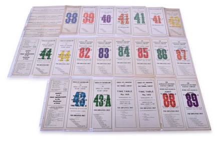
Twenty-Five Kansas City Southern Lines Railway Employee Timetables - 1931 to 1949Rail & Road Auctions4.6(165)See Sold PriceMar 08, 2024
Twenty-Three Kansas City Southern and Kansas City, Shreveport & Gulf Railway Employee Timetables -Rail & Road Auctions4.6(165)See Sold PriceMar 08, 2024
New and Correct Map of North America With the West India Islands,Jasper524.5(9.8k)See Sold PriceFeb 27, 2024
Carte du Golfe de Guinée'. Gulf of Guinea. Nigeria & Cameroon. BELLIN 1747 mapJasper524.5(9.8k)See Sold PriceFeb 28, 2024
Coste Occidentale d’Afrique…' West Africa. Gulf of Guinea. BELLIN 1746 mapJasper524.5(9.8k)See Sold PriceFeb 28, 2024
Gulf of Guinea. Ghana Togo Benin Nigeria. ADMIRALTY sea chart 1928 (1954) mapJasper524.5(9.8k)See Sold PriceFeb 28, 2024
Carte du Golfe de Guinée. Gulf of Guinea Nigeria Cameroon BELLIN/SCHLEY 1748 mapJasper524.5(9.8k)See Sold PriceFeb 28, 2024
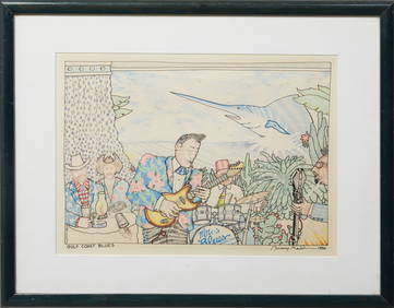
Bunny Matthews (American/Louisiana, 1951-2021), "Gulf Coast Blues," 1986, H.- 11 1/4 in., W.- 15 1/2Crescent City Auction Gallery4.3(229)See Sold PriceMar 09, 2024
LOU PINIELLA CHRIS SABO SIGNED OFFICIAL GULF COAST LEAGUE BALL CINCINNATI REDS3 Kings Auction4.3(194)See Sold PriceFeb 27, 2024