MATTHEWS c1856 Map Of Upper Canada Ontario Indian Land Agency Divisions Scarce!Luis Porretta Fine Arts4.3(10)See Sold PriceMar 02, 2024
DEVINE c1856 Dr Salters Map Of Lake Huron Ontario Indian Lands etc. No. 7 ScarceLuis Porretta Fine Arts4.3(10)See Sold PriceMar 02, 2024
DUNLEVIE c1856 Map Counties Of Gaspe & Bonaventure Quebec Canada SCARCE! #1Luis Porretta Fine Arts4.3(10)See Sold PriceMar 02, 2024
DUNLEVIE c1856 Map Counties Of Gaspe & Bonaventure Quebec Canada SCARCE! #2Luis Porretta Fine Arts4.3(10)See Sold PriceMar 02, 2024
Map UNITED COUNTIES LEEDS & GRENVILLE by Walling 1861 Rare Canada Map 5ft x 5ftLuis Porretta Fine Arts4.3(10)See Sold PriceMar 02, 2024
Ambroise TARDIEU c1822 Map Venice Napoleon Italian Campaign 17" x 11"Luis Porretta Fine Arts4.3(10)See Sold PriceMar 02, 2024
SoldJefferys Map of Pennsylvania after Scull, 1775JEFFERYS, Thomas (c. 1719-1771; After SCULL, Nicolas II (1687-1761). A Map of Pennsylvania exhibiting not only the Improved Parts of that Provinces, but also its Extensive Frontiers... Scull publishedSee Sold Price
SoldSCULL, William (after); and Thomas JEFFERYS. A MaSCULL, William (after); and Thomas JEFFERYS. A Map of Pennsylvania Exhibiting not only the Improved Parts of that Province, but also its Extensive Frontiers. [London: Sayer & Bennett, 1775].See Sold Price
Scull Map of Pennsylvania 1775A Map of Pennsylvania...William Scull (1739-1784). Engraved map. London: Sayer & Bennett, 1775. 29 1/2 x 54 inches sheet, 35 x 59 1/2 inches framed. Sayer and Bennett published this revised edition inSee Sold Price
SoldSCULL. A Map of Pennsylvania. 1775MAP - SCULL, William; after. A Map of Pennsylvania exhibiting not only the improved parts of that Province by also its extensive Frontier.London: Sayer & Bennett, 10 June 1775. Hand-colored eSee Sold Price
SoldAfter Thomas Jefferys (English), "Map of Pennsylvania,"After Thomas Jefferys (English), "Map of Pennsylvania," "Map of New York and New Jersey," "Map of Pennsylvania," "Map of New England," 1775, four 20th c. reproductions, (4 Pcs.), unframed, H.- 29 1/2See Sold Price
Sold(Maps and Charts, America), Sayer, Robert & Bennet(Maps and Charts, America), Sayer, Robert & Bennett, John, A Map of Pennsylvania...from the late Map of W. Scull Published in 1770, London, 1775, hand-colored, three sheets joined, framed, sight sizeSee Sold Price
Sold[Maps] Scull, W(illiam)., A Map of Pennsylvania...[Maps] Scull, W(illiam). A Map of Pennsylvania Exhibiting not only the Improved Parts of that Province, but also it's Extensive Frontiers... >London: Printed for Robt. Sayer & J. Bennett, 1775. EngravSee Sold Price
SoldWilliam Scull (American, 1739-1784), A Map ofWilliam Scull (American, 1739-1784), A Map of Pennsylvania Exhibiting Not Only the Improved Parts of that Province, but also its Extensive Frontiers London: Sayer and Bennett, 1775. matted and framed.See Sold Price
THOMAS JEFFERYS - MAP OF PENNSYLVANIA, 1776Thomas Jefferys - Map Of Pennsylvania, 1776 - Giclée On Canvas - 44 X 23 In. A Giclée Print Is The Highest Quality Print Available Today. Because There Is No Visible Dot Screen Pattern, The ResultinSee Sold Price
THOMAS JEFFERYS - MAP OF PENNSYLVANIA, 1776Thomas Jefferys - Map Of Pennsylvania, 1776 - 30 X 15 5/8 In. - This Giclée Print Is Gallery Stretched And Ready To Hang Or Lean Against A Wall, Or Display On An Easel. - A Giclée Print Is The HigheSee Sold Price
THOMAS JEFFERYS - MAP OF PENNSYLVANIA, 1776Thomas Jefferys - Map Of Pennsylvania, 1776 - 40 X 20 7/8 In. - This Giclée Print Is Gallery Stretched And Ready To Hang Or Lean Against A Wall, Or Display On An Easel. - A Giclée Print Is The HigheSee Sold Price
THOMAS JEFFERYS - MAP OF PENNSYLVANIA, 1776THOMAS JEFFERYS - MAP OF PENNSYLVANIA, 1776 - 36 x 18 3/4 in. - Museum Wrapped The Piece Of Art Is Ready To Hang Or Lean Against A Wall, Or Display On An Easel. - A Giclée Print Is The Highest QualitSee Sold Price
THOMAS JEFFERYS - MAP OF PENNSYLVANIA, 1776Thomas Jefferys - Map Of Pennsylvania, 1776 - 36 X 18 3/4 In. - Giclée Print - Gallery Stretched - Ready to hang.See Sold Price
THOMAS JEFFERYS - MAP OF PENNSYLVANIA, 1776Thomas Jefferys - Map Of Pennsylvania, 1776 - Giclée On Canvas - 36 X 18 3/4 In.~~A giclée print falls between serigraph and lithograph in quality. Although they can be made on paper, Giclees on canSee Sold Price
THOMAS JEFFERYS - MAP OF PENNSYLVANIA, 1776Thomas Jefferys - Map Of Pennsylvania, 1776 - 40 X 20 7/8 In. - This Giclée Print Is Gallery Stretched And Ready To Hang Or Lean Against A Wall, Or Display On An Easel. - A Giclée Print Is The HigheSee Sold Price
THOMAS JEFFERYS - MAP OF PENNSYLVANIA, 1776Thomas Jefferys - Map Of Pennsylvania, 1776 - Giclée On Canvas - 36 X 18 3/4 In.See Sold Price
Thomas Jefferys - Map Of Pennsylvania, 1776Thomas Jefferys - Map Of Pennsylvania, 1776 Size: 36 X 18 3/4 In. - This Is A Gallery Stretched Giclee Print On Canvas. The Piece Was Printed On High Quality Artist Grade 350 Gsm, Acid-free, ArchivalSee Sold Price
THOMAS JEFFERYS - MAP OF PENNSYLVANIA, 1776Thomas Jefferys - Map Of Pennsylvania, 1776 - 40 X 20 7/8 In. - This Giclée Print Is Gallery Stretched And Ready To Hang Or Lean Against A Wall, Or Display On An Easel. - A Giclée Print Is The HigheSee Sold Price
THOMAS JEFFERYS -MAP OF PENNSYLVANIA, 1776 - GICLÉE ONThomas Jefferys -map Of Pennsylvania, 1776 - Giclée On Canvas -40 X 20 7/8 In. - A Giclée Print Is The Highest Quality Print Available Today. Because There Is No Visible Dot Screen Pattern, The ResuSee Sold Price
THOMAS JEFFERYS - MAP OF PENNSYLVANIA, 1776Thomas Jefferys - Map Of Pennsylvania, 1776 - 36 X 18 3/4 In. - Giclée Print - Gallery Stretched - Ready to hang.See Sold Price
THOMAS JEFFERYS - MAP OF PENNSYLVANIA, 1776Thomas Jefferys - Map Of Pennsylvania, 1776 - 44 X 23 In. - This Giclée Print Is Gallery Stretched And Ready To Hang Or Lean Against A Wall, Or Display On An Easel. - A Giclée Print Is The Highest QSee Sold Price
THOMAS JEFFERYS - MAP OF PENNSYLVANIA, 1776Thomas Jefferys - Map Of Pennsylvania, 1776 - 36 X 18 3/4 In. - This Giclée Print Is Gallery Stretched And Ready To Hang Or Lean Against A Wall, Or Display On An Easel. - A Giclée Print Is The HigheSee Sold Price
THOMAS JEFFERYS - MAP OF PENNSYLVANIA, 1776Thomas Jefferys - Map Of Pennsylvania, 1776 - 44 X 23 In. - This Giclée Print Is Gallery Stretched And Ready To Hang Or Lean Against A Wall, Or Display On An Easel. - A Giclée Print Is The Highest QSee Sold Price
THOMAS JEFFERYS -MAP OF PENNSYLVANIA, 1776 - GICLÉE ONThomas Jefferys -map Of Pennsylvania, 1776 - Giclée On Canvas -44 X 23 In. - A Giclée Print Is The Highest Quality Print Available Today. Because There Is No Visible Dot Screen Pattern, The ResultinSee Sold Price
Ohio and Pennsylvania RR 1st Annual Report-1849JM Hobby Supply and Railroad Artifact Auctions4.4(127)See Sold PriceFeb 24, 2024
Ohio and Pennsylvania RR 2nd Annual Report-March 4, 1850JM Hobby Supply and Railroad Artifact Auctions4.4(127)See Sold PriceFeb 24, 2024
Ohio and Pennsylvania RR 2nd Annual Report-1850JM Hobby Supply and Railroad Artifact Auctions4.4(127)See Sold PriceFeb 24, 2024
Crams Township and Railroad Map of Pennsylvania-1898JM Hobby Supply and Railroad Artifact Auctions4.4(127)See Sold PriceFeb 24, 2024
Fort Wayne and Pennsylvania RR 1880 Public TimetableJM Hobby Supply and Railroad Artifact Auctions4.4(127)See Sold PriceFeb 24, 2024
Pennsylvania Central/Pittsburgh Ft Wayne and Chicago 1870 Public TimetableJM Hobby Supply and Railroad Artifact Auctions4.4(127)See Sold PriceFeb 24, 2024
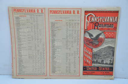
Pennsylvania Railroad July 8, 1885 Public TimetableJM Hobby Supply and Railroad Artifact Auctions4.4(127)See Sold PriceFeb 24, 2024
Pennsylvania Railroad May 29, 1904 Public TimetableJM Hobby Supply and Railroad Artifact Auctions4.4(127)See Sold PriceFeb 24, 2024
1888 Hand Book of the Pennsylvania Lines Containing Maps of Principal Cities - First EditionRail & Road Auctions4.6(165)See Sold PriceMar 07, 2024
1855 Guide for the Pennsylvania Railroad with an Extensive Map from the Pennsylvania RailroadRail & Road Auctions4.6(165)See Sold PriceMar 07, 2024
1876 The Centennial Exhibition Pennsylvania Railroad Worlds Fair Guide with Map and Trade CardRail & Road Auctions4.6(165)See Sold PriceMar 07, 2024
Early Pennsylvania Railroad Literature - 1881 New York and Chicago Limited Timetable Brochure andRail & Road Auctions4.6(165)See Sold PriceMar 07, 2024
1904 Pennsylvania Railroad Winter Excursions Book with Fold Out MapRail & Road Auctions4.6(165)See Sold PriceMar 07, 2024
Pair of Early Railroad Maps - 1874 Delaware, Lackawanna & Western and 1876 Pennsylvania RailroadRail & Road Auctions4.6(165)See Sold PriceMar 07, 2024
Pair of Early Railroad Maps - 1862 Pittsburgh, Ft. Wayne & Chicago Railway and 1873 PennsylvaniaRail & Road Auctions4.6(165)See Sold PriceMar 07, 2024
1822 MAP of LEEWARD ISLANDS GEOGRAPHICAL STATISTICAL HISTORICAL antique 17.5x22"Jasper524.5(9.9k)See Sold PriceFeb 27, 2024
1822 MAP of NORTH & SOUTH AMERICA GEOGRAPHICAL STATISTICAL HISTORICAL antiqueJasper524.5(9.9k)See Sold PriceFeb 27, 2024
George F. Cram - Historical Map of Pittsburgh Allegheny PennsylvaniaProverde Auctions4.3(3)See Sold PriceFeb 28, 2024
Vintage Street Map of Pittsburgh, Pennsylvania - Rand McNallyProverde Auctions4.3(3)See Sold PriceFeb 28, 2024
Monmouth, Illinois Vintage Topography MapRapid Estate Liquidators and Auction Gallery4.5(1.1k)See Sold PriceFeb 28, 2024
Antique Pennsylvania Map Fragment incl Wellersburg and New CentervilleCordier Auctions & Appraisals4.4(1.5k)See Sold PriceMar 02, 2024


![[Maps] Scull, W(illiam)., A Map of Pennsylvania... (1 of 1)](https://p1.liveauctioneers.com/65/182149/91633639_1_x.jpg?height=282&quality=70&version=1602635207)