ATLAS of ANTIENT GEOGRAPHY by SAMUEL BUTLER 1843John McInnis Auctioneers,LLC4.6(502)See Sold PriceFeb 24, 2024
18TH C. ANTIQUE MAP: FRENCH & INDIAN WAR, FRAMEDThomaston Place Auction Galleries4.4(386)See Sold PriceFeb 24, 2024
Rand McNally Railroad Map Cabinet w/ 21 Railroad MapsRail & Road Auctions4.6(165)See Sold PriceMar 08, 2024
Keith Haring - Ink on New York Map, Best Buddies, Inscribed, Signed, and DatedSapphire Auction Gallery4(67)See Sold PriceMar 02, 2024
LATE 17TH C. FRENCH MAP OF THE NEW WORLD BY ALEXIS-HUBERT JAILLOT (1632-1712)Thomaston Place Auction Galleries4.4(386)See Sold PriceFeb 24, 2024
Central Railroad of New Jersey Map of Sandy Hook Route-ca. 1903JM Hobby Supply and Railroad Artifact Auctions4.4(126)See Sold PriceFeb 24, 2024
Lot of Six Mixed Atlas Box Cars-HO Scale-New in BoxJM Hobby Supply and Railroad Artifact Auctions4.4(126)See Sold PriceFeb 25, 2024
Rand McNally/Santa Fe Railroad Map of Iowa-1912JM Hobby Supply and Railroad Artifact Auctions4.4(126)See Sold PriceFeb 24, 2024
NICOLAES VISSCHER (NETHERLANDS, 1618-1709) MAP OF THE NEW WORLDThomaston Place Auction Galleries4.4(386)See Sold PriceFeb 24, 2024
17TH C. WORLD MAP BY NICOLAES VISSCHER (NETHERLANDS, 1618-1709)Thomaston Place Auction Galleries4.4(386)See Sold PriceFeb 24, 2024
Lot of Six Mixed Atlas Cabooses-HO Scale-New in BoxJM Hobby Supply and Railroad Artifact Auctions4.4(126)See Sold PriceFeb 25, 2024
Jaillot/Sanson: Antique Map of the Balkans, 1716Title/Content of Map: LE ROYAUME DE HONGRIE, ET LES ESTATS QUI ONT ESTÉ SUJETS ET DEPENDANS DE SA COURONNE ...’ Date Printed: 1716 Cartographer: Published by Hubert Jaillot from the plate by NicolaSee Sold Price
Seutter: Antique Map Balkans, Hungary to Greece, 1740Title/Content of Map: Balkan's from Hungary to Greece Date Printed: c1740 Cartographer: Matthaus Seutter Material/Medium: Paper Size: 23 1/2" x 19 3/4" Original hand colored copperplate engraved. PublSee Sold Price
Tanner: Antique Map of Balkans with Greece, 1843Title/Content of Map: Balkans with Greece by Tanner Date Printed: 1843 Cartographer: H.C. Tanner Material/Medium: Paper Size: 17" x 14" Hand colored engraved Map based on the work of H.C. Tanner fromSee Sold Price
SoldTanner: Antique Map of Balkans with Greece, 1843Title/Content of Map: Balkans with Greece by Tanner Date Printed: 1843 Material/Medium: Paper Provenance: New York Please note that this lot has a confidential reserve. When you leave a bid in advanceSee Sold Price
Seutter: Antique Map of The Balkans, 1740Title/Content of Map: The Balkans or southeastern Europe Date Printed: c1740 Cartographer: Matthuas Seutter Material/Medium: Paper Size: 19" x 23" Original hand colored copperplate engraved. PublishedSee Sold Price
Homann Heirs: Antique Map of Hungary & Balkans, 1750Title/Content of Map: Hvngariae Ampliori Significatu... Carte D'hongrie En General..." Date Printed: 1750 ca. Cartographer: HOMANN HEIRS Publisher/Place: HOMANN HEIRS 1750 ca. NUREMBERG Size: Folio ��See Sold Price
Fries: Antique Map of Greece & Balkans, 1541Map: 1541 Fries Map of Greece and Balkans -- Tabula Nova Graeciae, Sclavoniae, & Bulgariae Cartographer: T Fries Year / Place: 1541, Vienna Map Dimensions: 12.8 x 15.8 in. Condition: Very Good. ClearSee Sold Price
SoldLattre: Antique Map of The Balkans, 1791Title/Content of Map: The Balkan's Date Printed: 1791 Cartographer: J Lattre Material/Medium: Paper Size: 11" x 8 1/2" Published in Petit Atlas Moderne Ou Collection De Cartes Elementaire. Published iSee Sold Price
Antique Colored Map - Europe - Balkans - Hungary - Romania - Bulgaria - HeirsOriginally colored engraved map of the Balkans by Johann Matthias Hase printed by Homann Heirs. Shows Hungary, Romania, Bulgaria, the former Yugoslavia (Croatia, Serbia, Bosnia, Macedonia), Albania anSee Sold Price
Homann Heirs: Antique Map of Hungary & North BalkansTitle/Content of Map: Hvngariae Ampliori Significatu... Carte D'hongrie En General..." Date Printed: 1750 ca. Cartographer: HOMANN HEIRS Size (inches): 7.9x6.4 Detailed map of Hungary and the northernSee Sold Price
Van Keulen: Antique Map of Gulf of Venice, 1716Title/Content of Map: Pas-Caart van de Weder zytsche Zee-kusten soo van Italia als Dalmatia en Griecken inde Golff van Venetien , , , 1716 [Large inset of Corfu] Date Printed: 1716 Cartographer: Van KSee Sold Price
Anonymous: Antique Chart Map of Dunkirk, England. 1716Map: Plan des environs de Dunkerque et Mardick avec le Nouveaux Canal fait pour l'ecoulement des eaux du pays a la mer Date Printed: 1716 Cartographer: Anonymous Size: 13 x 9 Condition: Good. Paper miSee Sold Price
Johnson's Austria, Turkey in Europe and Greece. Balkans 1865 old antique mapTITLE/CONTENT OF MAP: 'Johnson's Austria, Turkey in Europe and Greece // Candia' DATE PRINTED: 1865 IMAGE SIZE: Approx 45.5 x 63.0cm, 18 x 24.75 inches (Large); Please note that this is a folding map.See Sold Price
Johnson's Austria, Turkey in Europe and Greece. Balkans 1865 old antique mapTITLE/CONTENT OF MAP: 'Johnson's Austria, Turkey in Europe and Greece // Candia' DATE PRINTED: 1865 IMAGE SIZE: Approx 45.5 x 63.0cm, 18 x 24.75 inches (Large); Please note that this is a folding map.See Sold Price
Turkey in Europe Hungary. Balkans. PAYNE 1798 old antique map plan chartTITLE/CONTENT OF MAP: 'Turkey in Europe and Hungary' DATE PRINTED: 1798 IMAGE SIZE: Approx 18.5 x 22.0cm, 7.25 x 8.75 inches (Medium) TYPE: Antique copperplate engraved map with original hand colourinSee Sold Price
Turkey in Europe Hungary. Balkans. PAYNE 1798 old antique map plan chartTITLE/CONTENT OF MAP: 'Turkey in Europe and Hungary' DATE PRINTED: 1798 IMAGE SIZE: Approx 18.5 x 22.0cm, 7.25 x 8.75 inches (Medium) TYPE: Antique copperplate engraved map with original hand colourinSee Sold Price
SoldAN ANTIQUE CELESTIAL MAP, "Theoria PlanetarumAN ANTIQUE CELESTIAL MAP, "Theoria Planetarum Primariarum," NUREMBERG, 1716-1724, hand colored engraving on paper, a page fragment from Atlas Coelestis, plate number 4, after Johann Homann (1664-1724See Sold Price
Hungary with Turky in Europe. Balkans Greece Ukraine 1782 old antique mapTITLE/CONTENT OF MAP: 'Hungary with Turky in Europe' DATE PRINTED: 1782 IMAGE SIZE: Approx 18.5 x 22.5cm, 7.25 x 9 inches (Medium); Please note that this is a folding map. TYPE: Antique engraved coppeSee Sold Price
Hungary with Turky in Europe. Balkans Greece Ukraine 1782 old antique mapTITLE/CONTENT OF MAP: 'Europa cum Insulis et Regionibus intra Paludem Maeotida et Mare Hyrcanum sitis' DATE PRINTED: 1828 IMAGE SIZE: Approx 26.0 x 32.0cm, 10.25 x 12.5 inches (Large) TYPE: Antique coSee Sold Price
SoldAntique Maps: Turcic Imperii Imago, 2 Maps, oneDetailed map covering the Ottoman territories in the Balkans, Anatolia, Levant, Arabia and North Africa published by Henricus Hondius in Atlas sive Cosmographicae Meditationes de Fabrica Mundi et FabrSee Sold Price
Bonne: Antique Map of Turkey in Europe & Asia, 1780Title/Content of Map: 'La Turquie d'Europe et celle d'Asie'. A map of Turkey in Europe and Asia, the Balkans & Black Sea and the Levant Date Printed: 1780 Image Size: Approx 23.0 x 34.0cm, 9 x 13.5 inSee Sold Price
Sold(2) antique maps of Europe by Nicolas De Fer(2) antique maps of Europe by Nicolas De Fer, "Les Suisses, Leurs Sujets et Leurs Alliez", black and white map, 1715 and "Le Golfe De Venise", hand-colored map, 1716, by Nicolas De Fer and P. StarckmaSee Sold Price
Bonne: Antique Map of Turkey in Europe & Asia, 1780Title/Content of Map: 'La Turquie d'Europe et celle d'Asie' A map of Turkey in Europe and Asia, the Balkans & Black Sea and the Levant Date Printed: 1780 Image Size: Approx 23.0 x 34.0cm, 9 x 13.5 incSee Sold Price
SoldAntique Maps(lot of 2) Continental School (18th/19th century), Map of Mediterranean, from "La Geographie Sacree," 1716 and "Planisphere Physique," a map of the Southern Hempishere, engraved by Desbruslins, hand-cSee Sold Price
17TH C. ANTIQUE MAP SIEGE OF LA ROCHELLE, FRANCE, FRAMEDThomaston Place Auction Galleries4.4(386)See Sold PriceFeb 24, 2024
18TH C. ANTIQUE MAP: FRENCH & INDIAN WAR, FRAMEDThomaston Place Auction Galleries4.4(386)See Sold PriceFeb 24, 2024
Framed Hand Colored Antique Map of the Department of Nord, FranceDonny Malone Auctions4.5(1.7k)See Sold PriceMar 04, 2024
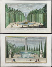
Demortain - 4 Fountain & Garden EngravingsTrillium Antique Prints & Rare Books4.5(30)See Sold PriceFeb 24, 2024
AFRICA. Pre 'Scramble for Africa'. BARTHOLOMEW 1876 old antique map plan chartJasper524.5(9.8k)See Sold PriceFeb 28, 2024
Cooke, George 1801 Antique Map. United States of AmericaAlbion Auctions4.6(336)See Sold PriceMar 01, 2024
Cooke, George 1801 Antique Map. Italy, Sicily, Sardinia & CorsicaAlbion Auctions4.6(336)See Sold PriceMar 01, 2024
Francis McNally - Antique Map of Ohio, Indiana & KentuckyProverde Auctions4.3(3)See Sold PriceFeb 28, 2024
Francis McNally - Antique Map of Washington, Oregon, Idaho, Nevada, Utah & ArizonaProverde Auctions4.3(3)See Sold PriceFeb 28, 2024
Antique Map of Poland, 1700 by Guillaume De Lisle, ParisAntiques Online Auctions4.6(407)See Sold PriceMar 14, 2024