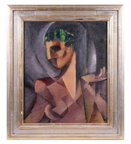
ITALIAN RENAISSANCE PERIOD PAINTINGThomaston Place Auction Galleries4.4(386)See Sold PriceFeb 24, 2024
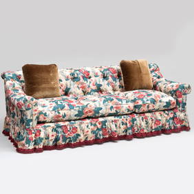
Linen Chintz Tufted Upholstered Three Seat Sofa, With a Fringed Skirt and A Pair of Leopard PillowsSTAIR4.6(286)See Sold PriceMar 06, 2024
A Greek Linen and Embroidered Robe A Yemeni Embroidered Robe A Syrian Textile with Cross-StitchNazmiyal Auctions4.4(34)See Sold PriceFeb 26, 2024
Vintage Woodmark Originals Inc., Mary Webb Wood, 1976, Wing Back Arm Chairs, PairNorthgate Gallery, Inc.4.5(34)See Sold PriceMar 02, 2024
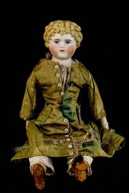
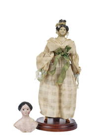
QUEEN ANNE DOLL & HEAD and SHOULDER PLATEJohn McInnis Auctioneers,LLC4.6(502)See Sold PriceFeb 24, 2024
FRANK W. HANDLEN (KENNEBUNKPORT, ME/NJ, 1916-2023)Thomaston Place Auction Galleries4.4(386)See Sold PriceFeb 25, 2024
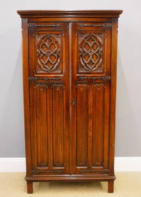
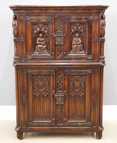
BOSTON LINEN PRESS ATTRIB. TO EMMONS & ARCHIBALD BOSTON, ORIGINAL BRASS (93" TALL X 50" WIDE X 20"Carlsen Gallery, Inc.4.6(163)See Sold PriceMar 03, 2024
SoldJacques-Petit 'Carte D Europe' 1946 Map PosterJacques-Petit 'Carte D Europe' 1946 Pictorial Map Poster. Poster depicts the foods of Europe with artwork by Pierre Herault. Poster has been professionally linen backed. Poster measures 23.5 x30.5" onSee Sold Price
SoldBellin (J N) Carte Réduite des Mers du NordBellin (Jacques Nicolas) Carte Réduite des Mers du Nord,the North sea, Labrador, Greenland, Iceland, Scandinavia, the British Isles, and the northern regions of northern Europe, engraved map wSee Sold Price
MAP, Russia in Europe, BellinRussia in Europe. Jacques Nicolas Bellin, Carte de la Moscovie Europeene. I. Feuille, 1764 (published). Hand Color. This striking map of Russia extends as far east as the Ural Mountains and Kama RiverSee Sold Price
SoldBELLIN (Jacques-Nicolas)BELLIN (Jacques-Nicolas) Le Petit atlas maritime. Recueil de cartes et plans des quatre parties du monde, en cinq volumes. [Paris] [ ,chez l’auteur] 1,764. 5 volumes in-4, veau havane marbré, dos �See Sold Price
Original 18th c. H/C Engraved Lattré Map of EuropeAntique Original Hand-colored Engraved Map of Europe from PETIT ATLAS MODERNE ou collection de cartes élémentaires dédié à la jeunesse | Engraved and published in Paris by Jean Lattr�See Sold Price
SoldOriginal 18th c. H/C Engraved Lattré Map of EuropeAntique Original Hand-colored Engraved Map of Europe from PETIT ATLAS MODERNE ou collection de cartes élémentaires dédié à la jeunesse | Engraved and published in Paris by Jean Lattr [Chez LattreSee Sold Price
SoldMap, N. BellinFramed engraved map of eastern North America, the Atlantic Ocean and Western Europe, ''Carte de l'Ocean Occidental et Partie de l'Amerique Septentrionale,'' by Jacques-Nicolas Bellin (French, 1703-177See Sold Price
SoldEuropean volume of Bellin's maritime atlas, 1764Heading: Author: Bellin, Jacques Nicolas Title: Le Petit Atlas Maritime. Tome IV. Contenant l'Europe et les Divers Etats qu'elle renferme excepté la France Place Published: Paris Publisher: DateSee Sold Price
Carte De La Petit Bukharie Et Pays VoisinsTitle: Carte De La Petit Bukharie Et Pays Voisins Publication Date: 1749 Cartographer: BELLIN, JACQUES NICOLAS, ELDER (1703-1772) Publisher: DIDOT Size: 8.6X12.25 "tiree des auteurs anglois pour serviSee Sold Price
SoldSet 3 Propaganda Posters UK WWII India Europe GreeceSet of three posters. 1. Original vintage propaganda poster – The Bureau Of Current Affairs – Map Review No. 2, 1946. Printed by Fosh & Cross Ltd., London. Contents: Map of changes in EuSee Sold Price
SoldBellin Map of the Atlantic Ocean 1766Jacques-Nicolas Bellin (1703-1772), "Carte Reduite de l'Ocean Occidental Contenant Partie des Costes d'Europe et d'Afrique: depuis le 51e degre de latitude septentrionale jusqu'a l'Equateur et cellesSee Sold Price
SoldGrp: 17 Maps from Nicolas Bellin "Le Petit AtlasThis lot includes 17 Jacques Nicolas Bellin (1703-1772) (Publisher: Didot, Paris) 18th Century Maps from "Le Petit Atlas Maritime Recueti de Cartes et Plans des Quatre Parlies du Monde en Cinq VolumesSee Sold Price
Sold1764 BELLIN JACQUES NICOLAS (1703 - 1772) INCISIONE in1764 BELLIN JACQUES NICOLAS (1703 - 1772) INCISIONE in bianco e nero "Isle de Sicile" (cm 20 x 33,5) tratta dal libro Petit atlas maritime recueil de cartes et plans des quatre parties du monde. AnnoSee Sold Price
SoldNouvelle Carte du Royaume de BengaleBy Jacques Nicolas Bellin, Paris, 1764[In Le Petit Atlas Maritime, vol. III]27.5 cm x 34.5 cm (H x W; all measurements are approximate)Original outline color (turquoise) to coast and rivers.*WatermarkSee Sold Price
Lot of 4 Maps of Bengal, 1747-1779Nouvelle Carte du Royaume de Bengale By Jacques Nicolas Bellin, Paris, 1764 In Le Petit Atlas Maritime, vol. III 27.5 cm x 34.5 cm (H x W; all measurements are approximate) Original outline color (turSee Sold Price
SoldMap, Jacques-Nicolas BellinJacques-Nicolas Bellin (French, 1703–1772), "Carte de L'Empire du Japon," engraving from the 'Petit Atlas Francois', "Plan de la ville et du port de Nangasaki," "Plan de Jedo," and "Plan de la VilleSee Sold Price
SoldJacques Nicholas Bellin (French, 1703-1772)Jacques Nicholas Bellin (French, 1703-1772), "Carte du Golphe du Mexique et des Isles de l'Amerique", 1754, hand-colored engraved map from Le Petit Atlas Maritime, 10 3/4 in. x 14 3/4 in., framedSee Sold Price
SoldJacques Nicolas Bellin MapsJacques Nicolas Bellin , "Plan de La Nouvelle Orleans" and "Carte des Embouchures du Mississipi", two hand-colored engraved maps, from Le Petit Atlas Maritime, 1764, 7 1/2 in. x 11 in., framed . ProveSee Sold Price
SoldBellin, Jacques Nicolas (1703-1772) Plan de la VilBellin, Jacques Nicolas (1703-1772) Plan de la Ville de Boston, and Carte de la Baye de Baston [sic]. from Petit Atlas Maritime. Paris, 1764. Two small folio engraved mSee Sold Price
MAPS, Nile River, Egypt, BellinNile River, Egypt. Jacques Nicolas Bellin, [Lot of 2] Carte des Embouchures du Nil, et Partie de son Cours le Delta et l'Isthme de Suez [and] Carte Exacte du Cours du Nil, from Le Petit Atlas MaritimeSee Sold Price
SoldBellin Jacques Nicolas et CroiseyBellin Jacques Nicolas et Croisey Carte de l’Isle de Corse. 1764, in Petit atlas maritime, tome IV - 22 x 40 cm.See Sold Price
Prémière Partie De La Carte D'Europe 1756 MapPrémière Partie De La Carte D'europe'. D'anville. Western Europe 1756 Old Map. Title/content of Map: 'prémière Partie De La Carte D'europe Contenant La France, L'alemagne, L'italie, L'espagne, & LSee Sold Price
SoldPair of German "Europe 1915" Illustrated Map PosterPair of German "Europe 1915" Illustrated Map Posters, Lucas Grafe, Sommerfchau uber Europa and Gedrangte Fruhjahrsubersicht von Europa im Jahre 1915, on linen, 22 x 27 3/4 in.See Sold Price
Carte de L'Europe. Map of Europe. MALTE-BRUN c1871 oldTITLE/CONTENT OF MAP: 'Carte de l'Europe [Map of Europe]' DATE PRINTED: c1871 IMAGE SIZE: Approx 33.5 x 46.5cm, 13.25 x 18.25 inches (Large); Please note that this is a folding map. TYPE: Antique 19thSee Sold Price
Two (2) Antique 18th C. Copper Engraved Framed Maps - America & EuropeMagnusson Art Group4.5(46)See Sold PriceMar 14, 2024
1758 MAP PARTIE DE LA MER GLACIALE contenants La Nouvelle Zemble RUSSIA antiqueJasper524.5(9.8k)See Sold PriceFeb 27, 2024
1749 MAP CARTE DE LA TARTARIE ORIENTALE RUSSIA & CHINA antique EASTERN TARTARYJasper524.5(9.8k)See Sold PriceFeb 27, 2024
Railways & Transport.- [Prospectus] The Dorking, Brighton, and Arundel Atmospheric Railway, byForum Auctions4.3(52)See Sold PriceFeb 29, 2024
1764 Bellin Map of Mari-Galante Near Guadeloupe -- Carte de l'Isle de Mari-GalanteJasper524.5(9.8k)See Sold PriceFeb 27, 2024
1764 Bellin Map of St. Kitts -- Carte de l'Isle St. ChristopheJasper524.5(9.8k)See Sold PriceFeb 27, 2024
1764 Bellin Map of Antigua -- Carte de l'Isle d'Antigue Situee par la Latitude 17 Degres et par laJasper524.5(9.8k)See Sold PriceFeb 27, 2024
1764 Bellin Chart of Three South Haitian Bays -- Carte des Bayes du Mesle des Flamands et deJasper524.5(9.8k)See Sold PriceFeb 27, 2024
Barthelemy, Jean 1790 Map. Greece - Essa sur la Bataille de PlateeAlbion Auctions4.6(336)See Sold PriceMar 01, 2024
Barthelemy, Jean 1790 Map. Greece - Plan de L'AcademieAlbion Auctions4.6(336)See Sold PriceMar 01, 2024
Barthelemy, Jean 1790 Map. Greece - Essai sur les Environs de DelphesAlbion Auctions4.6(336)See Sold PriceMar 01, 2024
Photography - Set of 10 CDV Photo - Portraits from EuropeProverde Auctions4.3(3)See Sold PriceFeb 28, 2024
Photography - Set of 20 CDV Photo - Portraits from EuropeProverde Auctions4.3(3)See Sold PriceFeb 28, 2024


![Railways & Transport.- [Prospectus] The Dorking, Brighton, and Arundel Atmospheric Railway, by (1 of 1)](https://p1.liveauctioneers.com/5458/319736/171654703_1_x.jpg?height=282&quality=70&version=1708010439)


