ATLAS of ANTIENT GEOGRAPHY by SAMUEL BUTLER 1843John McInnis Auctioneers,LLC4.6(504)See Sold PriceFeb 24, 2024
18TH C. ANTIQUE MAP: FRENCH & INDIAN WAR, FRAMEDThomaston Place Auction Galleries4.4(389)See Sold PriceFeb 24, 2024
Rand McNally Railroad Map Cabinet w/ 21 Railroad MapsRail & Road Auctions4.6(165)See Sold PriceMar 08, 2024
Keith Haring - Ink on New York Map, Best Buddies, Inscribed, Signed, and DatedSapphire Auction Gallery4.1(67)See Sold PriceMar 02, 2024
LATE 17TH C. FRENCH MAP OF THE NEW WORLD BY ALEXIS-HUBERT JAILLOT (1632-1712)Thomaston Place Auction Galleries4.4(389)See Sold PriceFeb 24, 2024
Central Railroad of New Jersey Map of Sandy Hook Route-ca. 1903JM Hobby Supply and Railroad Artifact Auctions4.4(126)See Sold PriceFeb 24, 2024
Lot of Six Mixed Atlas Box Cars-HO Scale-New in BoxJM Hobby Supply and Railroad Artifact Auctions4.4(126)See Sold PriceFeb 25, 2024
Rand McNally/Santa Fe Railroad Map of Iowa-1912JM Hobby Supply and Railroad Artifact Auctions4.4(126)See Sold PriceFeb 24, 2024
NICOLAES VISSCHER (NETHERLANDS, 1618-1709) MAP OF THE NEW WORLDThomaston Place Auction Galleries4.4(389)See Sold PriceFeb 24, 2024
17TH C. WORLD MAP BY NICOLAES VISSCHER (NETHERLANDS, 1618-1709)Thomaston Place Auction Galleries4.4(389)See Sold PriceFeb 24, 2024
Lot of Six Mixed Atlas Cabooses-HO Scale-New in BoxJM Hobby Supply and Railroad Artifact Auctions4.4(126)See Sold PriceFeb 25, 2024
SoldIndia.- Rennell (James) Description of the Roads inIndia.- Rennell (James) Description of the Roads in Bengal and Bahar, first edition, folding frontispiece map, double page table at end, map torn at folds and repaired, margins torn with slight loss,See Sold Price
-. Rennell (James) A Description of the Roads in B-. Rennell (James) A Description of the Roads in Bengal and Bahar,first edition, folding frontispiece map, double page table at end, map torn at folds and repaired, margins torn with slight loSee Sold Price
Rennell (James) A Description of the Roads in BenRennell (James) A Description of the Roads in Bengal and Bahar,first edition, folding frontispiece map, double page table at end, map torn at folds and repaired, margins torn with slight lossSee Sold Price
SoldIndia.- Rennell (James) A Bengal Atlas, with additionalIndia.- Rennell (James) A Bengal Atlas: containing Maps of the War and Commerce on that side of Hindoostan, second edition, letterpress title and contents leaf, engraved index map, double-page view anSee Sold Price
SoldIndia.- Rennell (James) A Map of the North Part ofIndia.- Rennell (James) A Map of the North Part of Hindostan or A Geographical Survey of the Provinces of Bengal, Bahar, Awd, Ellahabad, Agra and Delhi, detailed map of northern India, based upon RennSee Sold Price
SoldIndia.- Rennell (James) Memoir of a Map of Hindoostan;India.- Rennell (James) Memoir of a Map of Hindoostan; or the Mogul's Empire, second edition, 5 engraved maps, 4 folding, the large map in 2 parts, hand-coloured in outline and with large vignette, moSee Sold Price
SoldIndia.- Rennell (James) A Map of Hindoostan or theIndia.- Rennell (James) A Map of Hindoostan or the Mogul Empire, large detailed map of India and Sri Lanka, coveringthe Bay of Bengal, including the coasts of Myanmar and Thailand, engraving with handSee Sold Price
SoldIndia.- Rennell (James) A Map of the North Part ofIndia.- Rennell (James) A Map of the North Part of Hindostan or A Geographical Survey of the Provinces of Bengal, Bahar, Awd, Ellahabad, Agra and Delhi, detailed map of northern India, based upon RennSee Sold Price
Comparative Geography of Western AsiaTitle: A Treatise on the Comparative Geography of Western Asia Author: Rennell, James Description: 2 volumes. lxiv, (3)-390; viii, 420 pp. (8vo) 21.5x13.5 cm (8½x5¼") period full cSee Sold Price
SoldIndia.- Rennell (Major James) Five maps from Rennell'sIndia.- Rennell (Major James) Five maps from Rennell's 'Bengal Atlas', including 'The River Ganges from Patna to Surdah with Plans of Patna and Monghir', 'The River Ganges from Allahabad to Patna withSee Sold Price
SoldCassell's Illustrated History of IndiaTitle: Cassell's Illustrated History of India Author: Grant, James Description: 2 volumes. xii, 576; xii, 588 pp. Profusely illustrated with wood engravings. (4to) 10¼x7½, period half morocco and maSee Sold Price
SoldCassell's Illustrated History of IndiaTitle: Cassell's Illustrated History of India Author: Grant, James Description: 2 volumes. xii, 576; xii, 588 pp. Profusely illustrated with wood engravings. (4to) 10¼x7½, period half morocco and maSee Sold Price
SoldMill's History of British India 9 vols. 1848Title: The History of British India Author: Mill, James Description: With Notes and Continuation by Horace Hayman Wilson. 9 volumes. With 2 folding copper-engraved maps, 1 of them hand-colored in outlSee Sold Price
Mill's History of British India 9 vols. 1848Title: The History of British India Author: Mill, James Description: With Notes and Continuation by Horace Hayman Wilson. 9 volumes. With 2 folding copper-engraved maps, 1 of them hand-colored in outlSee Sold Price
SoldRennell (James) Neueste Karte von HindostanRennell (James) after. Neueste Karte von Hindostan, Bengalen etc., India, with large title cartouche with vignette of coastal scene, 'Britannia' and native figures, engraved map on 4 sheets, uSee Sold Price
Rennell (James) A Map of Bengal etcRennell (James) A Map of Bengal, Bahar, Oude & Allahabad, with part of Agra and Delhi exhibiting the Course of the Ganges from Hurdwar to the Sea,engraved map of northern India on 2 sheets, joSee Sold Price
Rennell (James) A Map of BengalRennell (James) A Map of Bengal, Bahar, Oude & Allahabad, with part of Agra and Delhi exhibiting the Course of the Ganges from Hurdwar to the Sea, engraved map of northern India on 2 sheets, jSee Sold Price
SoldRennell (James) A Map of Bengal etcRennell (James) A Map of Bengal, Bahar, Oude & Allahabad, with part of Agra and Delhi exhibiting the Course of the Ganges from Hurdwar to the Sea,engraved map of northern India on 2 sheets, joSee Sold Price
SoldRennell (James) A Map of Bengal, Bahar,Rennell (James) A Map of Bengal, Bahar, Oude & Allahabad, with part of Agra and Delhi exhibiting the Course of the Ganges from Hurdwar to the Sea,engraved map of northern India on 2 sheets, joSee Sold Price
SoldNimrod The Chase, The Road and The TurfTitle: The Chase, The Road and The Turf Author: Nimrod [Apperley, Charles James] Description: [xxii], 334 pp. Illustrated with portraits, color plates, etc. 10x7¼, red half morocco and tan cloth, spiSee Sold Price
Nimrod The Chase, The Road and The TurfTitle: The Chase, The Road and The Turf Author: Nimrod [Apperley, Charles James] Description: [xxii], 334 pp. Illustrated with portraits, color plates, etc. 10x7¼, red half morocco and tan cloth, spiSee Sold Price
SoldMill's History of British India 6 volumesHeading: 296367_14.jpg Author: Title: Mill, James Place Published: The History of British India Publisher:London Date Published: James Madden, et al. Description: 1840 6 volSee Sold Price
SoldIndia.- Horsburgh (James, publisher) This Chart of GoaIndia.- Horsburgh (James, publisher) This Chart of Goa and Murmagoa Roads, Surveyed in 1812, Is Inscribed to Capt. Jas. Horsburgh By his Friend David Inverarity, detailed chart showing from Aguada toSee Sold Price
SoldAfter Major James Rennell (1742-1830) British. "TheAfter Major James Rennell (1742-1830) British. "The Peninsula of India", Map, Unframed, 19" x 17", and Ten other various Maps of the World by other hands, Eleven (11).See Sold Price
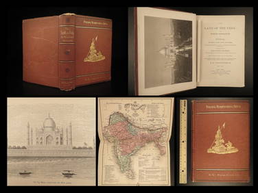
1872 INDIA Land of the Veda Travel Exploration Voyages Hindu Sepoy RebellionSchilb Antiquarian Rare Books4.8(422)See Sold PriceMar 31, 2024
Lot of 4 Vintage James Bond 007 Road Race HO Slot CarsBodnar's Auction Sales4.6(612)See Sold PriceMar 28, 2024
India.- Numismatics.- [Steuart (Sir James)] A Collection of Miscellanies relative to Coinage inForum Auctions4.3(53)See Sold PriceFeb 29, 2024
Pair of Antique East India Porcelain Plate & TureenAkiba Galleries4.7(1.8k)See Sold PriceFeb 29, 2024
INDIA WITHIN THE GANGES SUSAN GOLE ILLUSTRATED MAPS EARLY CARTOGRAPHYJasper524.5(9.8k)See Sold PriceFeb 27, 2024
WEST AFRICA Explorers' routes Senegal Ashanti. Mountains of Kong. SDUK 1857 mapJasper524.5(9.8k)See Sold PriceFeb 28, 2024
AFRICA. Map pre-dating much exploration. Mountains of Kong. SDUK 1851 oldJasper524.5(9.8k)See Sold PriceFeb 28, 2024
WEST AFRICA explorers' routes. Beaufort Gray Park Dochard Caillie. SDUK 1874 mapJasper524.5(9.8k)See Sold PriceFeb 28, 2024
WEST AFRICA I Explorers' routes Senegal Ashanti Ivory Gold Coast. SDUK 1851 mapJasper524.5(9.8k)See Sold PriceFeb 28, 2024
WEST AFRICA showing early explorers' routes & Mountains of Kong. SDUK 1844 mapJasper524.5(9.8k)See Sold PriceFeb 28, 2024
PRE COLONIAL WESTERN AFRICA. Shows Mountains of Kong. Tribes. WELLER 1863 mapJasper524.5(9.8k)See Sold PriceFeb 28, 2024
James Fitzmaurice-Kelly: Litterature espagnole. 1913 EditionChurchill Galleries3.7(216)See Sold PriceFeb 26, 2024
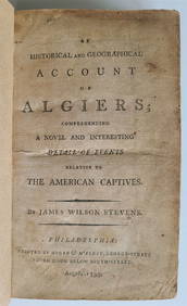
1797 PIRACY: A HISTORICAL & GEOGRAPHICAL ACCOUNT OF ANCIENNY Elizabeth 4.3(85)See Sold PriceMar 03, 2024


![India.- Numismatics.- [Steuart (Sir James)] A Collection of Miscellanies relative to Coinage in (1 of 1)](https://p1.liveauctioneers.com/5458/319736/171654578_1_x.jpg?height=282&quality=70&version=1708010439)