ATLAS of ANTIENT GEOGRAPHY by SAMUEL BUTLER 1843John McInnis Auctioneers,LLC4.6(502)See Sold PriceFeb 24, 2024
18TH C. ANTIQUE MAP: FRENCH & INDIAN WAR, FRAMEDThomaston Place Auction Galleries4.4(386)See Sold PriceFeb 24, 2024
Rand McNally Railroad Map Cabinet w/ 21 Railroad MapsRail & Road Auctions4.6(165)See Sold PriceMar 08, 2024
Keith Haring - Ink on New York Map, Best Buddies, Inscribed, Signed, and DatedSapphire Auction Gallery4(67)See Sold PriceMar 02, 2024
LATE 17TH C. FRENCH MAP OF THE NEW WORLD BY ALEXIS-HUBERT JAILLOT (1632-1712)Thomaston Place Auction Galleries4.4(386)See Sold PriceFeb 24, 2024
Central Railroad of New Jersey Map of Sandy Hook Route-ca. 1903JM Hobby Supply and Railroad Artifact Auctions4.4(126)See Sold PriceFeb 24, 2024
Lot of Six Mixed Atlas Box Cars-HO Scale-New in BoxJM Hobby Supply and Railroad Artifact Auctions4.4(126)See Sold PriceFeb 25, 2024
Rand McNally/Santa Fe Railroad Map of Iowa-1912JM Hobby Supply and Railroad Artifact Auctions4.4(126)See Sold PriceFeb 24, 2024
NICOLAES VISSCHER (NETHERLANDS, 1618-1709) MAP OF THE NEW WORLDThomaston Place Auction Galleries4.4(386)See Sold PriceFeb 24, 2024
17TH C. WORLD MAP BY NICOLAES VISSCHER (NETHERLANDS, 1618-1709)Thomaston Place Auction Galleries4.4(386)See Sold PriceFeb 24, 2024
Lot of Six Mixed Atlas Cabooses-HO Scale-New in BoxJM Hobby Supply and Railroad Artifact Auctions4.4(126)See Sold PriceFeb 25, 2024
SoldIndia.- Kitchin (Thomas) A New Map of Indostan or EastIndia.- Kitchin (Thomas) A New Map of Indostan or East Indies, map of India, with parts of Nepal and Tibet, Pakistan and Bangladesh, engraved map with hand-colouring on laid paper without watermark, pSee Sold Price
1773 India & 1761-9 India, “General Map of India…”A General Map of the East Indies and that part of China where the Europeans have any Settlements or commonly any Trade By Thomas Kitchin Engraved for the London Magazine, ca. 1761-9 30 cm x 42.5 cm WaSee Sold Price
SoldMiddle East.- Kitchin (Thomas) New map of Persia.Middle East.- Kitchin (Thomas) New map of Persia. Divided into its Provinces from the latest Authorities, engraving with hand-colouring on laid paper without watermark, sheet 435 x 360 mm (17 x 14 1/4See Sold Price
Blair (Rev. John) The East IndiesBlair (Rev. John) The East Indiesincluding more particularly The British Dominions on the Continent of India, engraved map by Thomas Kitchin, 430 x 575mm., on Whatman laid paper, watermarked 1See Sold Price
SoldKitchin, Thomas 1785 Antique Map of The East IndiesCopper Engraved Map Published 1783-85, London for "A New Geographical, Historical and Commercial Grammar..." by William Guthrie. Drawn and Engraved by Thomas Kitchin (Kitchen) and John Barber. Rare, ESee Sold Price
SoldRollos & Vaugondy 1765 Map of The East Indies & India"The East Indies distinguishing the Empires and Kingdoms on the Continent commonly call'd India" Copper Engraved Map Published 1764-66, London for "A New History of England..." by Thomas Mortimer. MapSee Sold Price
SoldMap of the European Settlements in the East IndiesBy Thomas Kitchin, Sr., (“Hydrographer to his Majesty”)Published by T. Cadell, (London), 178334 cm x 35 cm Watermarked paper (“VI” and a fleur de lis symbol). Mounted on archivSee Sold Price
SoldA General Map of India, including the Empire ofEngraved by Thomas Kitchin, 1773[In The Naval History of Great Britain; including the Lives of the Admirals, and other Illustrious Commanders and Navigators, Who have contributed to spread the Fame, aSee Sold Price
The East Indies, with the Roads, By Thomas Jefferys,Published by Robert Sayer, London, 1768 “To the Directors of the Honble East India Company, Thos Jefferys humbly Dedicates this Map.” a 53.5 cm x 138 cm b 55 cm x 138 cm Assembled: 108 cmSee Sold Price
SoldKitchin, Thomas. A New Map of North & South Carolina &Kitchin, Thomas. A New Map of North & South Carolina & Georgia"for the London Magazine," circa 1770, copperplate engraving without color. Presented in a mat, unframed. Plate 7 1/8 x 9.25 in. From a prSee Sold Price
SoldKITCHIN, THOMAS. A New Map of the British Empire inKITCHIN, THOMAS. A New Map of the British Empire in Nth. America. Hand-colored engraved folding map of colonial North America from George Millar's New and Universal System of Geography. 13½x15See Sold Price
SoldKitchin (Thomas) - A New Map of Edinburghshire,with ornamental title cartouche, engraved map with outline hand-colouring, 175 x 220mm., vertical folds, surface abrasions upper right, tipped into mount , [c.1760] § Bowen (Thomas) A New & AccurSee Sold Price
SoldKitchin (Thomas) A New Map of IrelandKitchin (Thomas) A New Map of Ireland Divided into Provinces, Counties , &c.,pictorial title cartouche depicting rural landscape (uncoloured), engraved map with full original hand-colouring, 6See Sold Price
SoldKitchin (Thomas) A New Map of EdinburghshireKitchin (Thomas) A New Map of Edinburghshire,with ornamental title cartouche, engraved map with outline hand-colouring, 175 x 220mm., vertical folds, surface abrasions upper right, tipped intoSee Sold Price
SoldKitchin (Thomas) A New Improved Map of NorthumberlKitchin (Thomas) A New Improved Map of Northumberland,engraved county map with large cartouche, dedication, and descriptive text, coloured by hand, dissected and mounted on damask, in originalSee Sold Price
SoldThomas Kitchin's New Map of Ireland Ca. 1795Laurie & Whittle Publishers circa 1795 map. Thomas Kitchins Hydrographer to his majesty. A New Map of Ireland Divided into Provinces & Counties. Frame: 27.5" x 24 3/8" image sight: 26.25" x 23 1/8". HSee Sold Price
Thomas Kitchin's New Map of Ireland Ca. 1795Laurie & Whittle Publishers circa 1795 map. Thomas Kitchins Hydrographer to his majesty. A New Map of Ireland Divided into Provinces & Counties. Frame: 27.5" x 24 3/8" image sight: 26.25" x 23 1/8". HSee Sold Price
MAP, Persia & the Caucasus, KitchinPersia & the Caucasus. Thomas Kitchin, New Map of Persia Divided into Its Provinces from the Latest Authorities, 1782 (circa). Hand Color. This attractive map covers the Persian Empire, which includedSee Sold Price
Kitchin (Thomas) Improved Map of HampshireKitchin (Thomas) A New Improved Map of Hampshire,engraved map partly hand-coloured in outline, dissected and linen-backed, 504 x 710 mm., n.d. [c.1760].See Sold Price
SoldThomas Kitchin, A New Map of China. 1782Thomas Kitchin, A New Map of China made by order of the Emperor. London, 1782. Published in George H. Millar's 'New Complete & Universal System of Geography'. Impression measures 13.5x15.25'' on 14.5xSee Sold Price
SoldTHOMAS KITCHIN - A NEW MAP OF THE KINGDOM OF FRANCE,Thomas Kitchin - A New Map Of The Kingdom Of France, 1790 - Giclée On Canvas 36 X 31 1/4 In. - A Giclée Print Is The Highest Quality Print Available Today. Because There Is No Visible Dot Screen PatSee Sold Price
SoldThomas Kitchin, "A New Map of England and Wales",Thomas Kitchin, "A New Map of England and Wales", Divided into Counties; Showing all the Cities, Burough and Market Towns, with the Roads & Drawn from the latest surveys", hand-colored copperplate engSee Sold Price
SoldAmerica.- Kitchin (Thomas) A New and Accurate Map ofAmerica.- Kitchin (Thomas) A New and Accurate Map of the British Dominions in America, According to the Treaty of 1763; Divided into the Several Provinces and Jurisdictions..., scarce unrecorded map oSee Sold Price
THOMAS KITCHIN - A NEW MAP OF ITALY WITH THE ISLANDS OFThomas Kitchin - A New Map Of Italy With The Islands Of Sicily, Sardinia & Corsica, 1790 - 25 7/8 X 30 In. - This Giclée Print Is Gallery Stretched And Ready To Hang Or Lean Against A Wall, Or DisplaSee Sold Price
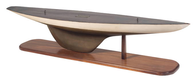
FULL HULL MODEL OF THE AMERICA'S CUP YACHT "COLUMBIA" Circa 1899 Height on stand 10". Length 49.5".Eldred's4.7(409)See Sold PriceFeb 27, 2024
Portfolio of 15 County Maps by Robert Morden (English 1650-1703)Nadeau's Auction Gallery4.7(401)See Sold PriceFeb 24, 2024
[ARCTIC]. BOWEN, Emanuel. A New & Accurate Map of the North...Potter & Potter Auctions4.6(539)See Sold PriceMar 07, 2024
[LITHOGRAPHY]. Group of 41 Trade Cards for American Domesti...Potter & Potter Auctions4.6(539)See Sold PriceMar 07, 2024
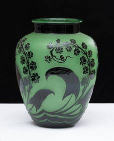
Steuben Acid-etched "Indian" Pattern Glass Vase, early 20th centuryCollective Hudson4.5(54)See Sold PriceMar 01, 2024
Great Apostle Saint Paul subduing the Evil Portuguese colonial of Goa, Portuguese colonial work fromTemplum Fine Art Auctions4.3(8)See Sold PriceFeb 28, 2024
Arrowsmith & Lewis - Map of North AmericaTrillium Antique Prints & Rare Books4.5(30)See Sold PriceFeb 24, 2024
Arrowsmith & Lewis - Map of the United StatesTrillium Antique Prints & Rare Books4.5(30)See Sold PriceFeb 24, 2024
Map: An 18thC engraved map titled A New and Improved Map of Oxfordshire.. after Thomas Kitchin.Claydon Auctioneers Ltd4.3(125)See Sold PriceFeb 26, 2024
New and Correct Map of North America With the West India Islands,Jasper524.5(9.8k)See Sold PriceFeb 27, 2024
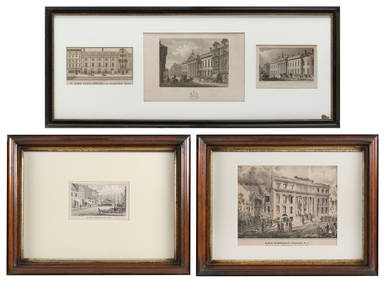
FIVE ARCHITECTURAL PRINTS OF HISTORIC NEW YORK AND LONDON BUILDINGS 19th CenturyEldred's4.7(409)See Sold PriceMar 07, 2024
Guthrie, William 1812 Antique Map. Spain and PortugalAlbion Auctions4.6(336)See Sold PriceMar 01, 2024


![[ARCTIC]. BOWEN, Emanuel. A New & Accurate Map of the North... (1 of 1)](https://p1.liveauctioneers.com/928/318880/171360917_1_x.jpg?height=282&quality=70&version=1707501302)
![[LITHOGRAPHY]. Group of 41 Trade Cards for American Domesti... (1 of 1)](https://p1.liveauctioneers.com/928/318880/171361100_1_x.jpg?height=282&quality=70&version=1707501302)