ATLAS of ANTIENT GEOGRAPHY by SAMUEL BUTLER 1843John McInnis Auctioneers,LLC4.6(502)See Sold PriceFeb 24, 2024
18TH C. ANTIQUE MAP: FRENCH & INDIAN WAR, FRAMEDThomaston Place Auction Galleries4.4(386)See Sold PriceFeb 24, 2024
Rand McNally Railroad Map Cabinet w/ 21 Railroad MapsRail & Road Auctions4.6(165)See Sold PriceMar 08, 2024
Keith Haring - Ink on New York Map, Best Buddies, Inscribed, Signed, and DatedSapphire Auction Gallery4(67)See Sold PriceMar 02, 2024
LATE 17TH C. FRENCH MAP OF THE NEW WORLD BY ALEXIS-HUBERT JAILLOT (1632-1712)Thomaston Place Auction Galleries4.4(386)See Sold PriceFeb 24, 2024
Central Railroad of New Jersey Map of Sandy Hook Route-ca. 1903JM Hobby Supply and Railroad Artifact Auctions4.4(126)See Sold PriceFeb 24, 2024
Lot of Six Mixed Atlas Box Cars-HO Scale-New in BoxJM Hobby Supply and Railroad Artifact Auctions4.4(126)See Sold PriceFeb 25, 2024
Rand McNally/Santa Fe Railroad Map of Iowa-1912JM Hobby Supply and Railroad Artifact Auctions4.4(126)See Sold PriceFeb 24, 2024
NICOLAES VISSCHER (NETHERLANDS, 1618-1709) MAP OF THE NEW WORLDThomaston Place Auction Galleries4.4(386)See Sold PriceFeb 24, 2024
17TH C. WORLD MAP BY NICOLAES VISSCHER (NETHERLANDS, 1618-1709)Thomaston Place Auction Galleries4.4(386)See Sold PriceFeb 24, 2024
Lot of Six Mixed Atlas Cabooses-HO Scale-New in BoxJM Hobby Supply and Railroad Artifact Auctions4.4(126)See Sold PriceFeb 25, 2024
SoldIllustrated Historical Atlas''Illustrated Historical Atlas, The State of Minnesota'', dated 1874, 18''h, 15''w, 1-3/4''d; cover loose and shows wear from use, pages 67-68 and 139-140 missing, tears, staining and folds throughoutSee Sold Price
Illustrated Historical Atlas of the State of Minnesota.Title/Content of Map: Illustrated Historical Atlas of the State of Minnesota. Date: 1874 Cartographer: A.T. Andreas Publisher: A.T. Andreas Size: 17.8"H x 14.5"W Irregular paging. Rare state atlas witSee Sold Price
Illustrated Historical Atlas of the State of Minnesota.Publication Date: 1874 Title: Illustrated Historical Atlas of the State of Minnesota. Primary Authors: A.T. Andreas Publisher: A.T. Andreas Irregular paging. Rare state atlas with an early national raSee Sold Price
SoldANDREAS, A. T. An Illustrated Historical AtlasANDREAS, A. T. An Illustrated Historical Atlas of the State of Minnesota. Profusion of hand-colored mapsheets, numerous lithographed views and portraits of local characters, plus 3 folding color lithoSee Sold Price
SoldANDREAS, A. T. An Illustrated Historical AtlasANDREAS, A. T. An Illustrated Historical Atlas of the State of Minnesota. Profusion of hand-colored mapsheets, numerous lithographed views and portraits of local characters. Folio, 440x370 mm, publishSee Sold Price
SoldANDREAS, A. T.; and BASKIN, FORSTER & Co. IlluANDREAS, A. T.; and BASKIN, FORSTER & Co. Illustrated Historical Atlas of the State of Indiana. Profusion of color printed mapsheets, numerous lithographed views and portraits of local characters. FolSee Sold Price
Sold1 vol. Baskin, Forster and Company. Ill1 vol. Baskin, Forster and Company. Illustrated Historical Atlas of the State of Indiana. Chicago, 1876. Folio, orig. 1/4 sheep & brown cloth, gilt; spine rubbed, hinges stressed. 149 color maps, plaiSee Sold Price
Sold[Atlas/Iowa]. Andreas, A.T. Illustrated Historical[Atlas/Iowa]. Andreas, A.T. Illustrated Historical Atlas Of The State Of Iowa. A. T. Andreas. 4to. (Iowa City: State Historical Society, 1970). 4to. 580pp. Leatherette. Very Good. **Full of drawings,See Sold Price
Sold[IOWA] - ANDREAS, Alfred Theodore (1839-1900) Ill[IOWA] - ANDREAS, Alfred Theodore (1839-1900) Illustrated Historical Atlas of the State of Iowa.Illustrated Historical Atlas of the State of Iowa. Chicago: 1875. Lithographic half title and dSee Sold Price
SoldMunger HISTORICAL ATLAS OF NEW YORK STATE 1941Title: Historical Atlas of New York State Editor: Wm. P. Munger Publisher: Frank E. Richards (Phoenix, NY) Printing Year: 1941 Condition/Details: This large folio vintage state atlas is illustrateSee Sold Price
Antique Hardesty Atlas of Ohio and World, 1882Title/Content of Map: 1882 Hardesty Atlas of Lawrence and Gallia Co., Ohio and World -- Historical Hand-Atlas Illustrated, Containing Large Scale Copper Plate Maps of Each State… Together with ComplSee Sold Price
Sold1882 Historical Hand Atlas, H. H. Hardesty Map1882 Historical Hand Atlas Illustrated, H. H. Hardesty 11.5 X 15. This Hard-to-find Atlas Has Been Rebound—it Will Look Great on Your Shelf. Several State Maps (texas/indian Territory, California/laSee Sold Price
Hardesty: Antique Atlas of Lawrence and Gallia Co, 1882Title/Content of Map: 1882 Hardesty Atlas of Lawrence and Gallia Co., Ohio and World -- Historical Hand-Atlas Illustrated, Containing Large Scale Copper Plate Maps of Each State… Together with ComplSee Sold Price
Sold1882 Hardesty Atlas of the USA, Bible Geography andTitle/Content of Map: 1882 Hardesty Atlas of the USA, Bible Geography and Lawrence Co., Ohio -- Historical Hand-Atlas Illustrated, Containing Large Scale Copper Plate Maps of Each State… Together wiSee Sold Price
SoldHistorical Hand-Atlas Illustrated Hardesty 1882Title: Historical Hand-Atlas Illustrated, Containing Large Scale Copper Plate Maps of Each State and Territory of the United States, and the Provinces of Canada, Together with a Complete Reference MapSee Sold Price
SoldH H Hardesty HISTORICAL HAND‐ATLASH H Hardesty HISTORICAL HAND‐ATLAS ILLUSTRATED COPPER PLATE MAPS 1882 Elephant Folio Antique Decorative Gilt Fold‐Out Engraved Tipped‐In Color Railroad US States Provinces Canada WorSee Sold Price
Scarce h/c map of southern states, Hardesty 1875Striking map of six southern states from the very scarce Jones & Hamilton version of H. Hardesty’s 1875 Historical Atlas of the World Illustrated. David Rumsey suggests this map and several others fSee Sold Price
Scarce h/c map of Plains states, Hardesty 1875A unique and pleasing map of five Plains states from the very scarce Jones & Hamilton version of H. Hardesty’s 1875 Historical Atlas of the World Illustrated. David Rumsey suggests this map and seveSee Sold Price
SoldH H Hardesty HISTORICAL HAND‐ATLASH H Hardesty HISTORICAL HAND‐ATLAS ILLUSTRATED COPPER PLATE MAPS 1882 Elephant Folio Antique Decorative Gilt Fold‐Out Engraved Tipped‐In Color Railroad US States ProvinceSee Sold Price
SoldNew Railroad Map of the United States and the Dominion of CanadaPublication Date: 1876 Title: New Railroad Map of the United States and the Dominion of Canada Cartographer: Publisher: BASKIN, FORSTER & CO. Height: 16.25 Width: 26 From their Illustrated HistoricalSee Sold Price
Sold(3) Early Florida Maps, Bloomfield, Colton, 1880sThree early Florida maps including Bloomfield's Illustrated Historical Guide to St. Augustine, along with two copies of G.W. & C.B. Colton's New Sectional Map of the State of Florida. All circa 1880s.See Sold Price
T. G. Bradford. UNITED STATES. Handcol. (1838).[UNITED STATES/Bradford Map] Map 4-5 from: T. G. Bradford. “An Illustrated Atlas, Geographical, Statistical, And Historical, Of The United States, And Adjacent Countries,” atlas published Bos: WeeSee Sold Price
SoldBradford TEXAS 1838 w/ South Boundary Neuces River[TEXAS.] Map 39 from T. G. Bradford, “An Illustrated Atlas, Geographical, Statistical, And Historical, Of The United States, And Adjacent Countries,” atlas published Bos: Weeks, Jordan, and CompanSee Sold Price
SoldMAP, Arkansas, BradfordArkansas. Thomas Gamaliel Bradford, Arkansas, from An Illustrated Atlas, Geographical, Statistical, and Historical, of the United States…, 1838 (dated). Hand Color. This copper engraved map by G.W.See Sold Price
ARMS, EQUIPMENT AND ATLAS of the CIVIL WAR 3 Book Set in New ConditionNorth American Artifact Auctions4.6(182)See Sold PriceApr 20, 2024
Illustrated World-Atlas and Gaszetteer by Hammond-Doubleday 1954North American Artifact Auctions4.6(182)See Sold PriceApr 20, 2024
HAMMOND'S READY REFERENCE HISTORICAL ATLAS 1920North American Artifact Auctions4.6(182)See Sold PriceApr 20, 2024
CTO Sterling silver Minnesota State Seal charmOmni Auction House Corp4.6(90)See Sold PriceFeb 29, 2024
RJL Vintage sterling silver Minnesota state charmOmni Auction House Corp4.6(90)See Sold PriceFeb 29, 2024
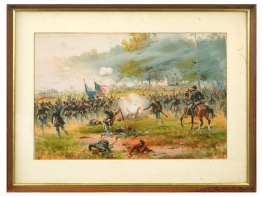
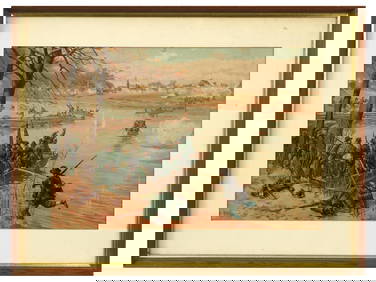
ANTIQUE AMERICAN CIVIL WAR LITHO BY THURE DE THULSTRUPAntique Arena Inc.4.5(852)See Sold PriceFeb 24, 2024
ANTIQUE AMERICAN CIVIL WAR LITHO BY THURE DE THULSTRUPAntique Arena Inc.4.5(852)See Sold PriceFeb 24, 2024
ANTIQUE AMERICAN CIVIL WAR LITHO BY THURE DE THULSTRUPAntique Arena Inc.4.5(852)See Sold PriceFeb 24, 2024
[CIGARETTE CARDS]. A Group of 22 “Ocean and River Steamers ...Potter & Potter Auctions4.6(539)See Sold PriceMar 07, 2024
Howard Hopalong Cassady 1955 Sports Illustrated 10/24 Ohio State 18942Mynt Auctions4.6(680)See Sold PriceFeb 28, 2024
[CIVIL RIGHTS]. A pair of 1936 publications related to the National Negro Congress.Freeman's | Hindman4.4(1.6k)See Sold PriceFeb 27, 2024
Wilson - Carolina Parrot & Flycatchers. 26Trillium Antique Prints & Rare Books4.5(30)See Sold PriceFeb 24, 2024
Book: A Concise Historical, Biographical & Genealogical Atlas of the Principal Events in theClaydon Auctioneers Ltd4.3(125)See Sold PriceFeb 26, 2024
Illustrated Historical Register 1876Chupp Auctions & Real Estate, LLC4.6(244)See Sold PriceMar 22, 2024
1948 T.B. Walker Indian Portraits Softcover BookMatthew Bullock Auctioneers4.7(1.8k)See Sold PriceMar 02, 2024
HISTORICAL ILLUSTRATED ANTIQUE 37 ENGRAVINGS FROM THE NETHERLANDS, 1744NY Elizabeth 4.3(84)See Sold PriceMar 03, 2024
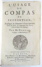
1691 APPLICATION OF COMPASS ILLUSTRATED HISTORICAL APPLICATION OF THE PROPORTION COMPANYNY Elizabeth 4.3(84)See Sold PriceMar 03, 2024
WORLD ILLUSTRATED HISTORICAL CHRONIC VOLUMES 2 FOLIO EDITION 1979NY Elizabeth 4.3(84)See Sold PriceMar 03, 2024
Robert H Labberton - Map of The Territory of the Present United States - The territory of theProverde Auctions4.3(3)See Sold PriceFeb 28, 2024


![[Atlas/Iowa]. Andreas, A.T. Illustrated Historical (1 of 1)](https://p1.liveauctioneers.com/179/1435/617472_1_x.jpg?height=282&quality=70)
![[IOWA] - ANDREAS, Alfred Theodore (1839-1900) Ill (1 of 2)](https://p1.liveauctioneers.com/839/22704/7944687_1_x.jpg?height=282&quality=70)


![[CIGARETTE CARDS]. A Group of 22 “Ocean and River Steamers ... (1 of 1)](https://p1.liveauctioneers.com/928/318880/171361499_1_x.jpg?height=282&quality=70&version=1707501302)

![[CIVIL RIGHTS]. A pair of 1936 publications related to the National Negro Congress. (1 of 5)](https://p1.liveauctioneers.com/197/319238/171467856_1_x.jpg?height=282&quality=70&version=1707520367)