SoldHOWELL, Reading (after) - Joseph T. SCOTT. A MapHOWELL, Reading (after) - Joseph T. SCOTT. A Map of the State of Pennsylvania from Mr. Howell's large Map. Philadelphia: [Matthew Carey?], c. 1794. Map engraved by Joseph T. Scott (310 x 510See Sold Price
Sold1793 Joseph T. Scott's map of Kentuckyfrom the United States Gazetteer. sight size: H6 1/4" W7 3/8"See Sold Price
Sold1795 Joseph T. Scott's Map of Southwest Territoryfrom the United States Gazetteer. site size: H6 1/4" W7 3/8"See Sold Price
Sold1795 Joseph T. Scott's Map of Northwest Territoryfrom the United States Gazetteer. sight size: H6 1/4" W7 3/8"See Sold Price
SoldAmerica,- The American Revolution.- Howell (Reading) AAmerica.- The American Revolution.- Howell (Reading) A Map of the State of Pennsylvania by Reading Howell, MDCCXCII To Thomas Mifflin Governor ... This Map is respectfully Inscribed by the Author, shoSee Sold Price
SoldHOWELL. A Map of the State of Pennsylvania. 1810MAP - HOWELL, Reading. A Map of the State of Pennsylvania.[Philadelphia]: 1810. Folding hand-colored engraved map (537x852 mm) engraved by J. Vallance after Howell. Sectioned and linen-backeSee Sold Price
SoldReading Howell MAP OF PENNSYLVANIA 1791 RareTitle: Map of Pennsylvania Publisher: Reading Howell (engraved by J. Trenchard) Medium: Antique map Year: 1791 Condition/Details: This antique map, inscribed to the Legislature and Governor of PenSee Sold Price
Reading Howell Map of PennsylvaniaA Reading Howell map of Pennsylvania, laid down on paper. Map: 20-3/4 x 26-1/2 in.See Sold Price
SoldHOWELL, Reading (after). A Map of the State of PeHOWELL, Reading (after). A Map of the State of Pennsylvania.Philadelphia: Kimber & Conrad, 1811. Map engraved by J. Vallance, hand-colored in outline (540 x 855 mm). Inset view of the SchuylSee Sold Price
SoldEarly 19th Century Map of Pennsylvania.Map titled "The State of Pennsylvania" reduced w/permission from Reading Howell's Map by Samuel Lewis. Engraved for Carey's American Edition of Gutherie's Geography Improved. Map measures 13" x 19" anSee Sold Price
Sold5V US Reference HISTORY OF MAPS OF NORTH AMERICA USA5V US Reference HISTORY OF MAPS OF NORTH AMERICA USA Cartography Books-On-Books 19th Century Alabama Dr John Mitchell Atlas Joseph Scott Southeast Early Maps Annotated Checklist Printed Manuscript LocSee Sold Price
Sold[Maps & Atlases] Scott, Joseph, The United States[Maps & Atlases] Scott, Joseph The United States Gazetteer: Containing an Authentic description of the Several States... Philadelphia: F. and R. Bailey, 1795. First edition. 12mo. vi, (288) pp. IllustSee Sold Price
SoldScott's US Gazetteer S.W. & N.W. Territory MapsDESCRIPTION: Southwest and Northwest Territory maps from Joseph Scott's The United States Gazetteer circa 1795. Includes: 1) N.W. Territory including Louisiana, Otogamies, Chippewa, Mascoutens, & CanaSee Sold Price
SoldJOSEPH T. SCOTT (AMERICAN, 18TH/19TH C.) MAP OFJOSEPH T. SCOTT (AMERICAN, 18TH/19TH C.) MAP OF VIRGINIA, on laid paper, titled "VIRGINIA" in upper left corner, above scale; printed for "The New and Universal Gazetteer". Late 18th century. 7 1/2" xSee Sold Price
SoldMap of Switzerland. "Joseph T.Scott, Sculpt." appxMap of Switzerland. "Joseph T.Scott, Sculpt." appx. 2" tear along right side, not affecting map. browning and stained. ss: 8"h x 11"wSee Sold Price
Atlas of the United States 1795-1800Publication Date: c1960 Title: Atlas of the United States 1795-1800 Primary Authors: SCOTT, JOSEPH Publisher: BLOCH AND COMPANY 1795 - 1800. Featuring maps produced by Joseph Scott. 4to, unpaged. facsSee Sold Price
Sold3 items: 1888 atlas, map, 1807 MD & DE geography.[Maryland/Philadelphia/Delaware]. 2 books + 1 map (total of 3). ++ Joseph Scott. A Geographical Description Of The States Of Maryland And Delaware; Also the Counties, Towns, Rivers, Bays and Islands.See Sold Price
Sold[MAP]. [SAN MATEO: HIGHLAND PARK]. N.P., n.d.366. [MAP]. [SAN MATEO: HIGHLAND PARK]. BALDWIN, Archibald S., Josiah R. Howell & Joseph H.P. Howard (agents). [Title on map verso] Map of Westerly Portion of San Mateo, Showing Highland Park andSee Sold Price
Sold1805 Wm. Kneass Map U.S. and Parts of LouisianaFrom A Geographical Dictionary of the United States of North America by Joseph Scott. Good condition; age toning, slight roll along top, small tear right side (with scotch tape repair to reverse), etcSee Sold Price
SoldTWO 18TH C. VT MAPS, J. SCOTT & J. WHITELAW.James Whitelaw 1794 engraved map of VT in an antique frame 21” x 17” overall, Joseph Scott 1795 State of Vermont in an antique frame 17” x 15” overall.See Sold Price
Sold3 Early Southern and TN Maps, inc. Mero District plusFour (4) items total, 3 unframed maps and 1 book excerpt. 1st item: Joseph Scott: THE SOUTHWEST TERRITORY, Scott's Gazetteer, Phila. 1795, showing the Mero district, Nashville, Knoxville, ClarksvilleSee Sold Price
SoldJoseph Scott bookSlott, Joseph- ''The United States Gazzetteer; Containing an Authentic Description of the Several States''- printed by F. and R. Bailey, Philadelphia, 1793, with all listed 10 maps hand bound in leathSee Sold Price
Sold1805 Geographical Dictionary of the United StatesA leather-bound book, "A Geographical Dictionary of the United States" by Joseph Scott, 1805: Archibald Bartram. Includes hand-colored, fold-out map.See Sold Price
SoldEarly Map of Tennessee, Daniel Smith, 1795A MAP OF THE TENNASSEE [sic] GOVERNMENT FORMERLY PART OF NORTH CAROLINA TAKEN CHIEFLY FROM SURVEYS BY GENL. D. SMITH & OTHERS, drawn by Daniel Smith, engraved by Joseph T. Scott, for "General Atlas FoSee Sold Price
Vintage Full Color World Map LithographThe Benefit Shop Foundation Inc.4.3(2.9k)See Sold PriceFeb 28, 2024
Nova Totius Full Color Geographical World MapThe Benefit Shop Foundation Inc.4.3(2.9k)See Sold PriceFeb 28, 2024
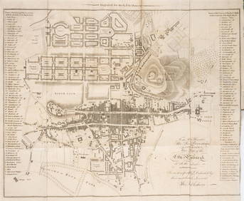
[MAP]. NICHOLLS, Sutton (1668-1729). An Epitome of Sr. Will...Potter & Potter Auctions4.6(545)See Sold PriceMar 07, 2024
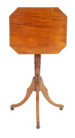
A GEORGE III MAHOGANY ADJUSTABLE READING TABLEHutchinson Scott Auctioneers4.4(42)See Sold PriceFeb 28, 2024
BACON'S ILLUSTRATED MAP OF YORKSHIRE 1876 BY EDWARD WELLER F.R.G.SHutchinson Scott Auctioneers4.4(42)See Sold PriceFeb 28, 2024
JANSSONS - A COLOURED MAP OF THE COUNTY OF WETMORLANDHutchinson Scott Auctioneers4.4(42)See Sold PriceFeb 28, 2024
A REGENCY MAHOGANY ADJUSTABLE OCCASIONAL/READING TABLEHutchinson Scott Auctioneers4.4(42)See Sold PriceFeb 28, 2024
A 19TH CENTURY HAND COLOURED MAP OF ORKNEY AND SHETLANDHutchinson Scott Auctioneers4.4(42)See Sold PriceFeb 28, 2024
AN ANTIQUE FOLDING MAP OF THE BRITISH ISLES DATED 1873Hutchinson Scott Auctioneers4.4(42)See Sold PriceFeb 28, 2024
1772 GREEK BIBLE NEW TESTAMENT antique BIBLIA LATIN text MAP NOVUM TESTAMENTUMJasper524.5(9.9k)See Sold PriceFeb 27, 2024
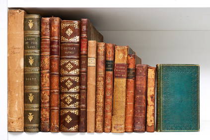
Cottle (Joseph) Alfred, an Epic Poem, in Twenty-Four Books, first edition, 1800; and others, 19thForum Auctions4.3(53)See Sold PriceFeb 29, 2024
Scotland.- Sir Walter Scott's Edinburgh.- The Post-Office annual directory, from Whitsunday 1808, toForum Auctions4.3(53)See Sold PriceFeb 29, 2024
JOSEPH KOSUTH (B. 1945) 'Double Reading #24', 1993 (This work is unique and accompanied by a cer...Bonhams4(320)See Sold PriceMar 01, 2024
SOUBERBIELLE JOSEPH: (1754-1846)International Autograph Auctions Europe S.L.4.4(52)See Sold PriceMar 14, 2024
A REGENCY MAHOGANY ADJUSTABLE OCCASIONAL/READING TABLEHutchinson Scott Auctioneers4.4(42)See Sold PriceJul 12, 2024


![[Maps & Atlases] Scott, Joseph, The United States (1 of 3)](https://p1.liveauctioneers.com/65/192593/97105501_1_x.jpg?height=282&quality=70&version=1611610147)


![[MAP]. [SAN MATEO: HIGHLAND PARK]. N.P., n.d. (1 of 5)](https://p1.liveauctioneers.com/514/38482/16500432_1_x.jpg?height=282&quality=70&version=1363615005)


![[MAP]. NICHOLLS, Sutton (1668-1729). An Epitome of Sr. Will... (1 of 1)](https://p1.liveauctioneers.com/928/318880/171361281_1_x.jpg?height=282&quality=70&version=1707501302)