ATLAS of ANTIENT GEOGRAPHY by SAMUEL BUTLER 1843John McInnis Auctioneers,LLC4.6(504)See Sold PriceFeb 24, 2024
18TH C. ANTIQUE MAP: FRENCH & INDIAN WAR, FRAMEDThomaston Place Auction Galleries4.4(389)See Sold PriceFeb 24, 2024
Rand McNally Railroad Map Cabinet w/ 21 Railroad MapsRail & Road Auctions4.6(165)See Sold PriceMar 08, 2024
Keith Haring - Ink on New York Map, Best Buddies, Inscribed, Signed, and DatedSapphire Auction Gallery4.1(67)See Sold PriceMar 02, 2024
LATE 17TH C. FRENCH MAP OF THE NEW WORLD BY ALEXIS-HUBERT JAILLOT (1632-1712)Thomaston Place Auction Galleries4.4(389)See Sold PriceFeb 24, 2024
Central Railroad of New Jersey Map of Sandy Hook Route-ca. 1903JM Hobby Supply and Railroad Artifact Auctions4.4(126)See Sold PriceFeb 24, 2024
Lot of Six Mixed Atlas Box Cars-HO Scale-New in BoxJM Hobby Supply and Railroad Artifact Auctions4.4(126)See Sold PriceFeb 25, 2024
Rand McNally/Santa Fe Railroad Map of Iowa-1912JM Hobby Supply and Railroad Artifact Auctions4.4(126)See Sold PriceFeb 24, 2024
NICOLAES VISSCHER (NETHERLANDS, 1618-1709) MAP OF THE NEW WORLDThomaston Place Auction Galleries4.4(389)See Sold PriceFeb 24, 2024
17TH C. WORLD MAP BY NICOLAES VISSCHER (NETHERLANDS, 1618-1709)Thomaston Place Auction Galleries4.4(389)See Sold PriceFeb 24, 2024
Lot of Six Mixed Atlas Cabooses-HO Scale-New in BoxJM Hobby Supply and Railroad Artifact Auctions4.4(126)See Sold PriceFeb 25, 2024
Homann: Antique Map of coastline of Lazio, 1745The map shows the coastline of Lazio with its hinterland from Rome (marked on the left hand edge of the map) south to Capo Circeo (right hand edge) DATE PRINTED: 1745 (This date is printed on the map)See Sold Price
SoldHomann: Antique Map of Lazio, Italy, 1745The map shows the coastline of Lazio with its hinterland from Rome (marked on the left hand edge of the map) south to Capo Circeo (right hand edge) Date Printed: 1745 (This date is printed on the map)See Sold Price
Homann Heirs: Antique Maps of British Colonies, 1745Map: Dominia Anglorum in America Septentrionali Subtitle: Dominia Anglorum in America Septentrionali Specialibus Mappis Londini primum a Mollio edita nune recusa ab Homannianis Hered. Creator: HomannSee Sold Price
Homann: Antique Map of the Papal Province, 1745Title/Content of Map: Patrimonio di S. Pietro. The map shows part of the west coast of Italy between Rome and Orbetello. Civitavecchia is shown in the centre of the coast. Other tows marked include ViSee Sold Price
JOHANN BAPTIST HOMANN BELGIUM MAPJOHANN BAPTIST HOMANN BELGIUM MAP: Flanders Old antique map of the coastline of Belgium with fortified towns and decorative title cartouche. By Johann Baptist Homann. Approx., 21'' h x 24'' w.See Sold Price
Il Lazio con le sue piu cospicue strade antiche eReserve Reduced! The map shows the coastline of Lazio with its hinterland from Rome (marked on the left hand edge of the map) south to Capo Circeo (right hand edge) DATE PRINTED: 1745 (This date is prSee Sold Price
SoldHomann: Antique Map of Italy, 1720Title/Content of Map: Italia Cursoria'. Italy general map Date Printed: c1720 Image Size: Approx 52.0 x 63.0cm, 20.5 x 24.75 inches (Large); Please note that this is a folding map. Type: Large antiqueSee Sold Price
Homann: Antique Map of the Americas, 1746Very beautiful map of America, big size, coloured by hand. Author: Homann Johan Baptist (1674-1724) publiched by Eredi Atlante: Maior Atlas scholasticus ex triginta sex generalibus et specialibus. DatSee Sold Price
Homann: Antique Map of the Solar System, 1752Title/Content of Map: 1752 Homann Solar System Map -- Systema Solare et Planetarium ex hypothesi Copernicana secundum elegantissimas Illustrissimi quondam Hugenii deductiones novissime collectum & exhSee Sold Price
Homann: Antique Map of Malta & Valetta View, 1720Map: Insularum Maltae et Gozae Cartographer: J. B. Homann Place & Date: Nurnberg / 1720 Size: 20" x 18" Condition: old color on islands and inset plan, cartouche and inset view in b&w; light overall aSee Sold Price
Homann: Antique Map of North & South America, 1740Map: Totius Americae Septentrionalis et Meridionalis Novissima Repraesentatio quam ex singulus recentium Geographorum Tabulis collecta luci publicae accomodavit Cartographer: HOMANN, Johannes BaptistaSee Sold Price
Homann: Antique Map of the World in Hemispheres, 1720Map: Planiglobii Terrestris Cumutroo Hemisphaerio Celesti Date Printed: 1720 Cartographer: J. B. Homann Material/Medium: Paper Size: 21" x 24" Condition: Excellent One of the most decorative world mapSee Sold Price
Homann: Antique Map of New England, 1720The map names New England as "Almouchi Cosen" as well as Nova Anglia, while present-day New York State is named variously as New Jork, Nieuw Nederland and Novum Belgium (New York, New Netherlands andSee Sold Price
Homann: Antique Map of New England, 1720Nova Anglia'.New England Novum Belgium.Long Island Jorck Shire. The map names New England as "Almouchi Cosen" as well as Nova Anglia, while present-day New York State is named variously as New Jork, NSee Sold Price
Homann: Antique Map of Denmark, 1720Map: Antique Map of Denmark -- Regni Daniae in quo sunt Ducatus Holsatia et Slesvicum Insulae Danicae Provinciae Iutia Scania Blekingia Nova Tabula Cartographer: J. Homann Year / Place: 1720 c NurnberSee Sold Price
SoldHomann: Antique Map of SouthEast Europe, 1753Title/Content of Map: 1753 Homann Map os the Danube and SouthEast Europe -- Fluviorum in Europa principis Danubii cum adiacentibus Regnis nec non totius Graeciae et Archipelagi Novissima Tabula Date PSee Sold Price
SoldJ.B. HOMANN ANTIQUE MAP OF MEXICO & NEW SPAINJ. B. Homann's map of Mexico, Florida, New England, the West Indies, and the Mississippi Valley. Dimensions: (Frame) H 20.5" x W 24.5", (Sight) H 18.5" x W 22..25" Condition: Colors faded. Some wear tSee Sold Price
Homann: Antique Map British Colonies in North AmericaDominia Anglorum in America Septentrionali'. The map shows British Possessions in North America in four panels. Top left: The gulf of St Lawrence with Newfoundland, New Brunswick and Nova Scotia. TopSee Sold Price
Homann: Antique Map of Germany, Poland, Austria, 1753Map: 1753 Homann Map of Germany, Poland, Austria -- Imperii Romano-Germanici in svos Status et Circulos divisi Tabula Generalis in Usus Iuventutis eru diendae… Cartographer: J. Homann Year / Place:See Sold Price
Homann: Antique Map of Danube, Southeast Europe, 1753Map: 1753 Homann Map of the Danube and Southeast Europe -- Fluviorum in Europa principis Danubii cum adiacentibus Regnis nec non totius Graeciae et Archipelagi Novissima Tabula Cartographer: J. HomannSee Sold Price
Homann: Antique Map of Danube & Southeast Europe, 1753Map: 1753 Homann Map of the Danube and SouthEast Europe -- Fluviorum in Europa principis Danubii cum adiacentibus Regnis nec non totius Graeciae et Archipelagi Novissima Tabula Date Printed: 1753 NurnSee Sold Price
SoldHomann: Antique Map of Spain & Portugal, 1753Title/Content of Map: 1753 Homann Map of Spain and Portugal -- Regnorum Hispaniae et Portugalliae, Tabula generalis de l' Isliana, aucta et ad Usum Scholarum… Date Printed: 1753 Nurnberg CartographeSee Sold Price
SoldHomann: Antique Map of Sicily Kingdom/Islands, 1747Title/Content of Map: Regni & insulae Siciliae'. Sicily kingdom/islands. Isole Eolie. The Contado (Contea) di Modica, or county of Modica is shown in red. The Aeolian Islands are marked at the top ofSee Sold Price
Homann: Antique Map of Crete & Aegean Islands, 1730Title/Content of Map: Insula Creta hodie Candia Cartographer: Homann Place & Date: Nuremberg / 1730 Size: 23" x 19" Condition: light browning along center fold; some staining along bottom of center foSee Sold Price
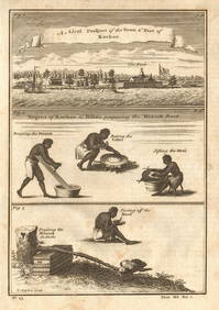
Guinea-Bissau Cacheu town Fortaleza de São José da Amura Preparing cassava 1745Jasper524.5(9.8k)See Sold PriceFeb 28, 2024
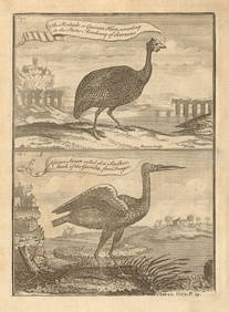
Pintado or Guinea-Hen. African Swan, or Gambian Stork. West African birds 1745Jasper524.5(9.8k)See Sold PriceFeb 28, 2024
West coast of Africa from Cape Blanco… Arguin bay, Mauritania. LABAT 1745 mapJasper524.5(9.8k)See Sold PriceFeb 28, 2024
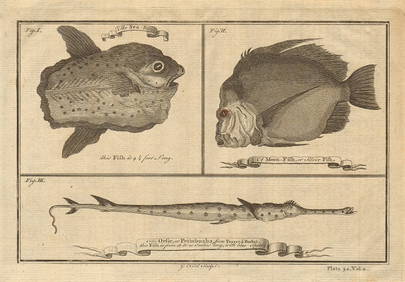
Ocean sunfish. Opah Moonfish. Orsie Petinbuaba Filefish. West African Fish 1745Jasper524.5(9.8k)See Sold PriceFeb 28, 2024
Coast & Islands between Cape Roxo. Guinea-Bissau & Bissagos. KITCHIN 1745 mapJasper524.5(9.8k)See Sold PriceFeb 28, 2024
La Barbarie de la Nigritie et de la Guinée'. West Africa. DE L’ISLE 1745 mapJasper524.5(9.8k)See Sold PriceFeb 28, 2024
West African fruit. Kola nut. Guava fruit. Kalabash Calabash tree 1745 printJasper524.5(9.8k)See Sold PriceFeb 28, 2024
Gambian birds. Monoceros. A bird with four wings. CHILD 1745 old antique printJasper524.5(9.8k)See Sold PriceFeb 28, 2024
East coast of Africa from the Cape… South Africa Mozambique. CHILD 1745 mapJasper524.5(9.8k)See Sold PriceFeb 28, 2024
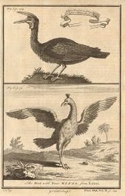
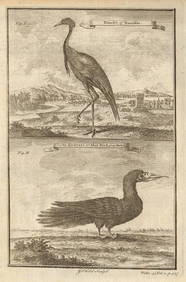
West African Birds. Crane Demoiselle. Alcatrazi or Mad-Bird. Albatross 1745Jasper524.5(9.8k)See Sold PriceFeb 28, 2024
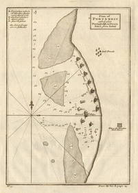
Plan of Portendic… Portu d'Addi or Penia. Portendick Mauritania. LABAT 1745 mapJasper524.5(9.8k)See Sold PriceFeb 28, 2024
Western coast of Africa… to the River Sanaga. Southern Mauritania LABAT 1745 mapJasper524.5(9.8k)See Sold PriceFeb 28, 2024
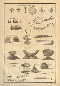
West Africa gold trinkets worn as spells and utensils. jewels ornaments 1745Jasper524.5(9.8k)See Sold PriceFeb 28, 2024