ATLAS of ANTIENT GEOGRAPHY by SAMUEL BUTLER 1843John McInnis Auctioneers,LLC4.6(502)See Sold PriceFeb 24, 2024
18TH C. ANTIQUE MAP: FRENCH & INDIAN WAR, FRAMEDThomaston Place Auction Galleries4.4(386)See Sold PriceFeb 24, 2024
Rand McNally Railroad Map Cabinet w/ 21 Railroad MapsRail & Road Auctions4.6(165)See Sold PriceMar 08, 2024
Keith Haring - Ink on New York Map, Best Buddies, Inscribed, Signed, and DatedSapphire Auction Gallery4(67)See Sold PriceMar 02, 2024
LATE 17TH C. FRENCH MAP OF THE NEW WORLD BY ALEXIS-HUBERT JAILLOT (1632-1712)Thomaston Place Auction Galleries4.4(386)See Sold PriceFeb 24, 2024
Central Railroad of New Jersey Map of Sandy Hook Route-ca. 1903JM Hobby Supply and Railroad Artifact Auctions4.4(126)See Sold PriceFeb 24, 2024
Lot of Six Mixed Atlas Box Cars-HO Scale-New in BoxJM Hobby Supply and Railroad Artifact Auctions4.4(126)See Sold PriceFeb 25, 2024
Rand McNally/Santa Fe Railroad Map of Iowa-1912JM Hobby Supply and Railroad Artifact Auctions4.4(126)See Sold PriceFeb 24, 2024
NICOLAES VISSCHER (NETHERLANDS, 1618-1709) MAP OF THE NEW WORLDThomaston Place Auction Galleries4.4(386)See Sold PriceFeb 24, 2024
17TH C. WORLD MAP BY NICOLAES VISSCHER (NETHERLANDS, 1618-1709)Thomaston Place Auction Galleries4.4(386)See Sold PriceFeb 24, 2024
Lot of Six Mixed Atlas Cabooses-HO Scale-New in BoxJM Hobby Supply and Railroad Artifact Auctions4.4(126)See Sold PriceFeb 25, 2024
Holland Map of St. JohnHolland, Samuel (1728-1801). A Map of the Island of St. John... Engraved map with original hand color in full. London, 1775. Published by Thomas Jefferys in the American Atlas. 21 3/4" x 30" sheet, 26See Sold Price
Antique Map of St. John Island (PEI) c1770Title: A Plan of the Island of St. John with the division of the Counties, Parishes & the Lots as granted by Government. Surveyed by Capt. Holland, 1765. Date: c1770. Second state of the map publishedSee Sold Price
Sold(CANADA.) Holland, Samuel; and Jefferys, Thomas. A Plan(CANADA.) Holland, Samuel; and Jefferys, Thomas. A Plan of the Island of St. John with the Divisions of the Counties Parishes & the Lots as Granted by Government Likewise the Soundings Round the CoastSee Sold Price
Booth Poverty Map: St John's Wood, 1902Map: 'Map G - Hampstead & St John's Wood (1900)' Date Printed: 1902 Image Size: Approx 45.0 x 29.0cm, 17.75 x 11.5 inches (Large) Type: Antique coloured linen-backed folding map. Artist/Cartographer/ESee Sold Price
LSE POVERTY OS PROOF MAP St Johns Wood Maida Vale Lisson Grove Regents Park 1928Title: LSE POVERTY OS PROOF MAP St Johns Wood Maida Vale Lisson Grove Regents Park 1928 Description: [Ordnance Survey] Edition of 1915 - London Sheet IV. 8. - Middlesex Sheet XVI. 8. St John's Wood -See Sold Price
BOOTH POVERTY MAP St John's Wood Hampstead Maida Vale Belsize Park Swiss C 1902Title: BOOTH POVERTY MAP St John's Wood Hampstead Maida Vale Belsize Park Swiss C 1902 Description: Map G - Hampstead & St John's Wood (1900)' by Charles Booth assisted by Jesse Argyle, Ernest Aves, GSee Sold Price
St. John's Harbour, Antigua. West Indies. The Lesser Antilles 1885 old mapTITLE/CONTENT OF MAP: 'St. John's Harbour, Antigua' DATE PRINTED: 1885 IMAGE SIZE: Approx 13.0 x 12.0cm, 5 x 4.75 inches (Small) TYPE: Antique wood-engraved map; Scale 1:40,000 CONDITION: Good; suitabSee Sold Price
St. John's Harbour, Antigua. West Indies. The Lesser Antilles 1885 old mapTITLE/CONTENT OF MAP: 'St. John's Harbour, Antigua' DATE PRINTED: 1885 IMAGE SIZE: Approx 13.0 x 12.0cm, 5 x 4.75 inches (Small) TYPE: Antique wood-engraved map; Scale 1:40,000 CONDITION: Good; suitabSee Sold Price
SoldImportant early map of St. Johns Island by T. JefferysA Map of the Island of St. John in the Gulf of St. Laurence...Thomas Jefferys (c. 1719 – 1771). Copperplate engraved map with handcolor in outline. London: Sayer & Bennett, 1775. 21 1/2 x 29 inchesSee Sold Price
SoldFRAMED MAP OF ST JOHN'S COLLEGE, CAMBRIDGEDavid Loggan, Collegium Sancti Johannis Evangelistae, double page engraving (of St Johns College Cambridge), 52 x 42cmSee Sold Price
SoldAtkinson (T.W.) Travels in AmoorAtkinson (T.W.) Travels in the regions of the upper and lower Amoor, tinted frontispiece, folding map, 1860 § St. John (H.C.) Notes and sketches from the wild coasts of Nipon, plates, foldingSee Sold Price
SoldFramed map, Jacques Nicholas Bellin, 1757, CanadaFramed handcolored map, Jacques Nicholas Bellin, 1757, Carte De L'Acadie, Isle Royale, et Pais Voisins...., map of Acadia, St. John's Island and the region extending to the St. John River in NortheastSee Sold Price
SoldBURROUGHS, Edgar Rice (1875-1950). Lost on VenusBURROUGHS, Edgar Rice (1875-1950). Lost on Venus.Tarzana: Edgar Rice Burroughs, Inc., 1935. Illustrated by St. John, map endpapers. Original blue cloth, red-stamped on upper cover and spine,See Sold Price
SoldTRAVEL. FANCOURT. HISTORY F YUCATAN.LONDON 1854. ORIGINAL CLOTH WITH MAP. BY CHARLES ST. JOHN FANCOURT. FINE COPY.See Sold Price
SoldBURROUGHS, Edgar Rice (1875-1950). Lost on Venus.BURROUGHS, Edgar Rice (1875-1950). Lost on Venus.Tarzana: Edgar Rice Burroughs, Inc., 1935. Illustrated by St. John, map endpapers. Original blue cloth, red-stamped on upper cover and spine,See Sold Price
SoldNautical Custom Tray and Towel HolderThe piece is hand crafted custom work featuring a St. Thomas & St. Johns Map surrounded by a wood frame and rope skirting. The tray also has chrome rope tie off. These are Mid-Century collectible's. TSee Sold Price
SoldGroup of 15 antique silver souvenir spoons11 Marked Sterling or 800, four spoons unmarked. All excellent quality and details. Includes Austria, Holland, Antwerp, Berne, Munchen, St, John, etc. total weighable silver over 5 OZTSee Sold Price
SoldTallis, John (Pub) 1852 Map. Holland. NetherlandsSteel Engraved Map with Original Outline Hand Color Published 1852-56 by John Tallis, London for "The Universal Pronouncing Dictionary" by Thomas Wright. Drawn & Engraved by John Rapkin. Centre fold aSee Sold Price
SoldSAYER, ROBERT. A Map of the Island of St. JohnSAYER, ROBERT. A Map of the Island of St. John in the Gulf of St. Laurence. Double-page engraved map, 380x715 mm, wide margins; hand-colored in outline; small closed tear just entering image from righSee Sold Price
BAYSWATER MAIDA VALE Paddington Bayswater Westbourne Park St Johns Wood 1900 mapTitle: BAYSWATER MAIDA VALE Paddington Bayswater Westbourne Park St Johns Wood 1900 map Description: Sheet 43 from Bacon's 1900 London street atlas covering part of West London including Paddington, BSee Sold Price
Map of West Indies Islands, St. Vincent, 1817Map: West Indies Islands. St. Vincent Maker: John Thomson & Co, Junr & Co. Date: 1817 Size: Double Folio, 19.6 inches high x 11.3 inches wide Part of No.52 from Thomson's New General Atlas 1817. KirkwSee Sold Price
SoldHOLLAND (BRITISH 1805-1880) St. Michael's MountHOLLAND, JOHN, BRITISH , " St. Michael's Mount, Cornwall" , oil on canvas 30 x 50 1/4 in (76.2 x 127.6 cm) signed lower leftSee Sold Price
SoldHand Colored Map St. Francisco De CampecheHand Colored Map St. Francisco De Campeche by John Ogilby, London, 1671 - Excellent condition - 11 3/4" x 14 1/4"See Sold Price
SoldBURROUGHS, Edgar Rice (1875–1950). Pellucidar. Chicago:BURROUGHS, Edgar Rice (1875–1950). Pellucidar. Chicago: A. C. McClurg, 1923. 8vo. Four sepia plates including frontispiece by J. Allen St. John and a map drawn by Burroughs. Publisher’s brSee Sold Price
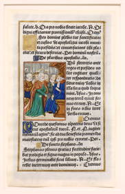
Illuminated Manuscript Leaf of St. JohnSchmidt's Antiques Inc. Since 19114.8(431)See Sold PriceMar 02, 2024
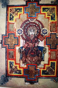
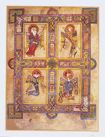
THE BOOK OF KELLS 3 x Limited Edition Serigraph Hand Made Prints Celtic ArtLuis Porretta Fine Arts4.3(10)See Sold PriceMar 02, 2024
THE BOOK OF KELLS 3 x Limited Edition 30 Color Serigraph Prints Celtic ArtLuis Porretta Fine Arts4.3(10)See Sold PriceMar 02, 2024
17TH C. MAP OF THE BERKSHIRES BY JOHN SPEED, FRAMEDThomaston Place Auction Galleries4.4(386)See Sold PriceFeb 24, 2024
John Boydell / Carlo Dolci 1768 Scarce Engraving Death of St Andrew 17" x 12"Luis Porretta Fine Arts4.3(10)See Sold PriceMar 02, 2024
Spanish school, XVII century. "Calvary. The Virgin and St. John before the Holy City". Oil on panel.Setdart Auction House4.1(22)See Sold PriceFeb 28, 2024
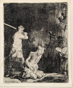
Rembrandt van Rijn. The Beheading of St. John the Baptist (1640). New Hollstein 183, III/III FairlyTremont Auctions4.6(293)See Sold PriceFeb 25, 2024
St. John Collection Luxury Knit Cardigan, USAThe Benefit Shop Foundation Inc.4.3(2.9k)See Sold PriceFeb 28, 2024
St John Starfish Sweater w Saks 5th Garment BagThe Benefit Shop Foundation Inc.4.3(2.9k)See Sold PriceFeb 28, 2024
St John 2 Pc Cardigan Jacket/Skirt Knit EnsembleThe Benefit Shop Foundation Inc.4.3(2.9k)See Sold PriceFeb 28, 2024
ANTIQUE RUSSIAN ICON ST JOHN CHRYSOSTOM W SILVER RIZAAntique Arena Inc.4.5(852)See Sold PriceFeb 24, 2024
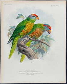
Mivart & Keulemans - Mitchell's LoryTrillium Antique Prints & Rare Books4.5(30)See Sold PriceFeb 24, 2024
Mivart & Keulemans - Verreaux's LoryTrillium Antique Prints & Rare Books4.5(30)See Sold PriceFeb 24, 2024
Mivart & Keulemans - Tahiti Lory, Ultramarine LoryTrillium Antique Prints & Rare Books4.5(30)See Sold PriceFeb 24, 2024
Mivart & Keulemans - Black-capped Lory & Red-breasted LoryTrillium Antique Prints & Rare Books4.5(30)See Sold PriceFeb 24, 2024
1764 Bellin Map of Antigua -- Carte de l'Isle d'Antigue Situee par la Latitude 17 Degres et par laJasper524.5(9.8k)See Sold PriceFeb 27, 2024
Russian Icon of St. John Chrysostom, 19th c., H.- 12 1/4 in., W.- 10 1/2 in.Crescent City Auction Gallery4.3(229)See Sold PriceMar 09, 2024
ST JOHN COLLECTION 2 PIECE KNIT OUTFIT SZ 10DejaVu Estate Sales & Auctions, LLC4.6(1.3k)See Sold PriceFeb 26, 2024