ATLAS of ANTIENT GEOGRAPHY by SAMUEL BUTLER 1843John McInnis Auctioneers,LLC4.6(504)See Sold PriceFeb 24, 2024
18TH C. ANTIQUE MAP: FRENCH & INDIAN WAR, FRAMEDThomaston Place Auction Galleries4.4(389)See Sold PriceFeb 24, 2024
Rand McNally Railroad Map Cabinet w/ 21 Railroad MapsRail & Road Auctions4.6(165)See Sold PriceMar 08, 2024
Keith Haring - Ink on New York Map, Best Buddies, Inscribed, Signed, and DatedSapphire Auction Gallery4.1(67)See Sold PriceMar 02, 2024
LATE 17TH C. FRENCH MAP OF THE NEW WORLD BY ALEXIS-HUBERT JAILLOT (1632-1712)Thomaston Place Auction Galleries4.4(389)See Sold PriceFeb 24, 2024
Central Railroad of New Jersey Map of Sandy Hook Route-ca. 1903JM Hobby Supply and Railroad Artifact Auctions4.4(126)See Sold PriceFeb 24, 2024
Lot of Six Mixed Atlas Box Cars-HO Scale-New in BoxJM Hobby Supply and Railroad Artifact Auctions4.4(126)See Sold PriceFeb 25, 2024
Rand McNally/Santa Fe Railroad Map of Iowa-1912JM Hobby Supply and Railroad Artifact Auctions4.4(126)See Sold PriceFeb 24, 2024
NICOLAES VISSCHER (NETHERLANDS, 1618-1709) MAP OF THE NEW WORLDThomaston Place Auction Galleries4.4(389)See Sold PriceFeb 24, 2024
17TH C. WORLD MAP BY NICOLAES VISSCHER (NETHERLANDS, 1618-1709)Thomaston Place Auction Galleries4.4(389)See Sold PriceFeb 24, 2024
Lot of Six Mixed Atlas Cabooses-HO Scale-New in BoxJM Hobby Supply and Railroad Artifact Auctions4.4(126)See Sold PriceFeb 25, 2024
SoldHistoire Generale Des Voiages with Maps, 1759Histoire Generale Des Voiages 1759 with fold-out maps. We ship most items in-house with the exception of furniture, large or heavy artwork, heavier items or extremely fragile items.See Sold Price
SoldJacques-Nicolas Bellin Map of Iceland ca. 1759Jacques-Nicolas Bellin (1703-1772) "Carte de L'Islande pour servir a la Continuation de l'Histoire generale des Voyages," ca. 1759. This engraved map of Iceland features a detailed depiction of the coSee Sold Price
SoldJacques-Nicolas Bellin Map of Iceland ca. 1759Jacques-Nicolas Bellin (French, 1703-1772). "Carte de L'Islande pour servir a la Continuation de l'Histoire generale des Voyages," ca. 1759. This engraved map of Iceland features a detailedSee Sold Price
Sold1759 Bellin Map Carte De L'isle De Saint DomingueMap of “Carte De L'Isle De Saint Domingue Pour Servir A L'histoire Generale Des Voyages Par M. B. Ing. De La Marine” By Jacques Bellin, , Printed At Paris 1759. Fine, Measures 15.5 X 10”. PleaseSee Sold Price
Suite Du Bresil, 1759Map: Suite du Bresil (Brazil) Publishing: Didot, Anville, J. B. B., Paris, 1759 Size: Octavo, 9.3 x 6.75 inches Described: "pour servir a l'Histoire generale des voyages... Tire de la carte d'AmeriqueSee Sold Price
c1758 Hand Colored Map of South AmericaHand colored map of South America by Jacques Bellin published circa 1759 entitled "Carte De L'Amerique Meridionale Pour l'Histoire Generale des Voyages". On fine paper. Light corner creases, else FineSee Sold Price
c1758 Hand Colored Map of South AmericaHand colored map of South America by Jacques Bellin published circa 1759 entitled "Carte De L'Amerique Meridionale Pour l'Histoire Generale des Voyages". On fine paper. Light corner creases, else FineSee Sold Price
Sold"Histoire Generale des Voiages" Paris 1754"Histoire Generale Des Voiages ou Nouvelle collection De Toutes les Relations De Voiages par Mer et par Terre, Qui ont ete publiees jusqu'a present dans les differentes Langues de toutes les Nations cSee Sold Price
SoldPrevost, Antoine Francois (Traductor). HistoirePrevost, Antoine Francois (Traductor). Histoire Générale des Voïages. Paris: Chez Didot, 1754.See Sold Price
SoldChina.- Bellin (Jacques Nicolas) L'Empire de la ChineChina.- Bellin (Jacques Nicolas) L'Empire de la Chine pour Servir a l'Histoire Generale des Voyages, map of China and Korea, with Canton, Nanking, and Taiwan described, title cartouche featuring floweSee Sold Price
SoldCarte de lOcean Occidental. North Atlantic Ocean FerroTITLE/CONTENT OF MAP: 'Carte de lOcean Occidental dressée pour servir à l'Histoire Generale des Voyages [Map of the Western Ocean]' DATE PRINTED: 1746 IMAGE SIZE: Approx 33.0 x 47.0cm, 13 x 18.5 incSee Sold Price
SoldAustralasia.- South Pacific.- Bellin (Jacques Nicolas)Australasia.- South Pacific.- Bellin (Jacques Nicolas) Carte Reduite de la Mer du Sud pour Servir a l'Histoire Generale des Voyages, map showing Eastern Australia with dotted lines, and joining both TSee Sold Price
Suite de l'Inde en deçà du Gange' South India Sri LankaTITLE OF THE MAP: 'Suite de la carte de l'Inde en deçà du Gange IIe Feuille, comprenant la Presqu'isle de l'Inde Pour servir à l'Histoire Générale des Voyages' A map of southern India and Sri LanSee Sold Price
SoldBellin: Map of Mexico City & Lake Texcoco, 1758Map Title: 'Carte du Lac de Mexique, et de ses Environs. Lors de le Conqueste des Espagnols Pour servir à l'Histoire Générale des Voyages' A map of Spanish colonial Mexico City on an island in LakeSee Sold Price
Sold3 Maps/Engravings incl: CARTE DE LA VIRGINIE...[North America/US/France] 3 Engravings. ++ CARTE DE LA VIRGINIE, DE LA BAYE CHESAPEACK, et Pays Voisins. Pour server a l’Histoire Generale des Voyages… Folding map. [Bellin. C. 1760s-1770s]. 7 ½�See Sold Price
Bellin: Antique Map of Southern India, 1758TITLE OF THE MAP: 'Suite de la carte de l'Inde en deçà du Gange IIe Feuille, comprenant la Presqu'isle de l'Inde Pour servir à l'Histoire Générale des Voyages' A map of southern India and Sri LanSee Sold Price
Bellin/Arkstee & Merkus: Detailed St. Lucia MapReserve Reduced! Bellin's elegant and highly detailed map of St. Lucia for Prevost's influential Histoire Générale des Voyages. The map is rich in topographical detail and place names and includes aSee Sold Price
SoldBellin/Arkstee & Merkus: Antique Map of Barbados, 1760Karte von der Insel Barbade Bellin's small map of Barbados for Prevost's influential Histoire Generale des Voyages. The map shows the island divided into parishes and includes many topographical detaiSee Sold Price
Bellin: Map of South India Sri Lanka Ceylon, 1758TITLE OF THE MAP: 'Suite de la carte de l'Inde en deçà du Gange IIe Feuille, comprenant la Presqu'isle de l'Inde Pour servir à l'Histoire Générale des Voyages' A map of southern India and Sri LanSee Sold Price
SoldBellin: Southern Africa / Cape of Good HopeBellin's map of southern Africa ("Hottentot country"), from the atlas of Prevost d'Exiles' influential collection of travel narratives, Histoire Generale des Voyages. The map extends from Saint HelenaSee Sold Price
Bellin: Antique Map of South America, 1754Amerique Meridionale Pour servir a l'Histoire Generale des Voyages Bellin's distinctive map of the South American continent, from the atlas of Prevost d'Exiles' influential travel book, Histoire GenerSee Sold Price
Bellin: Antique Map of Greenland and Iceland, 1770Carte du Groenland A beautifully engraved (and preserved) map of Greenland and Iceland, from Prevost d'Exiles' influential collection of travel narratives, Histoire Generale des Voyages. The map encomSee Sold Price
Suite de l'Inde en deçà du Gange' South India Sri LankaTITLE OF THE MAP: 'Suite de la carte de l'Inde en deçà du Gange IIe Feuille, comprenant la Presqu'isle de l'Inde Pour servir à l'Histoire Générale des Voyages' A map of southern India and Sri LanSee Sold Price
Bellin, Map of ArabiaCarte de la Coste D'Arabie, Mer Rouge, et Golfe de Perse. J. Nicolas Bellin (1703-1772). from L'Histoire Generale des Voyages. Engraved map. Paris, 1746-88. 9 1/2 x 11 1/2 inches sheetSee Sold Price
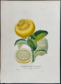
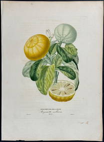
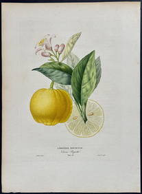
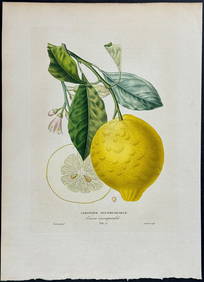
Risso - Lemon or Citrus Fruit. 73Trillium Antique Prints & Rare Books4.5(30)See Sold PriceFeb 24, 2024
Risso - Lemon or Citrus Fruit. 71Trillium Antique Prints & Rare Books4.5(30)See Sold PriceFeb 24, 2024
Linocier's L'Histoire des plantes - Volume with Numerous In Text Natural History Illustrations toTrillium Antique Prints & Rare Books4.5(30)See Sold PriceFeb 24, 2024
Albin - Bald or Vulturine Eagle. 2-3Trillium Antique Prints & Rare Books4.5(30)See Sold PriceFeb 24, 2024
Albin - King Vulture or Warwounen. 2-4Trillium Antique Prints & Rare Books4.5(30)See Sold PriceFeb 24, 2024
1758 MAP PARTIE DE LA MER GLACIALE contenants La Nouvelle Zemble RUSSIA antiqueJasper524.5(9.8k)See Sold PriceFeb 27, 2024
1749-1771 HISTORY OF ROMAN EMPERORS 12 VOLUMES antique ILLUSTRATED w/ MAPSJasper524.5(9.8k)See Sold PriceFeb 27, 2024
1749 MAP CARTE DE LA TARTARIE ORIENTALE RUSSIA & CHINA antique EASTERN TARTARYJasper524.5(9.8k)See Sold PriceFeb 27, 2024
Railways & Transport.- [Prospectus] The Dorking, Brighton, and Arundel Atmospheric Railway, byForum Auctions4.3(53)See Sold PriceFeb 29, 2024
1774: AN ANTIQUE ILLUSTRATED TWO-VOLUME HISTORY OF PERUVIAN DISCOVERY AND CONQUEST WITH MAPNY Elizabeth 4.3(85)See Sold PriceMar 03, 2024
Pieter Mortier (1661-1711) - Set of 2 Biblical Engravings - "Death of Herod Agrippa" - "PaulProverde Auctions4.3(3)See Sold PriceFeb 28, 2024
Pieter Mortier (1661-1711) - Set of 2 Biblical Engravings - "The apostles Paulus and Barnabas in theProverde Auctions4.3(3)See Sold PriceFeb 28, 2024


![Railways & Transport.- [Prospectus] The Dorking, Brighton, and Arundel Atmospheric Railway, by (1 of 1)](https://p1.liveauctioneers.com/5458/319736/171654703_1_x.jpg?height=282&quality=70&version=1708010439)


