ATLAS of ANTIENT GEOGRAPHY by SAMUEL BUTLER 1843John McInnis Auctioneers,LLC4.5(494)See Sold PriceFeb 24, 2024
18TH C. ANTIQUE MAP: FRENCH & INDIAN WAR, FRAMEDThomaston Place Auction Galleries4.4(386)See Sold PriceFeb 24, 2024
Rand McNally Railroad Map Cabinet w/ 21 Railroad MapsRail & Road Auctions4.6(165)See Sold PriceMar 08, 2024
Keith Haring - Ink on New York Map, Best Buddies, Inscribed, Signed, and DatedSapphire Auction Gallery3.9(67)See Sold PriceMar 02, 2024
LATE 17TH C. FRENCH MAP OF THE NEW WORLD BY ALEXIS-HUBERT JAILLOT (1632-1712)Thomaston Place Auction Galleries4.4(386)See Sold PriceFeb 24, 2024
Central Railroad of New Jersey Map of Sandy Hook Route-ca. 1903JM Hobby Supply and Railroad Artifact Auctions4.4(126)See Sold PriceFeb 24, 2024
Lot of Six Mixed Atlas Box Cars-HO Scale-New in BoxJM Hobby Supply and Railroad Artifact Auctions4.4(126)See Sold PriceFeb 25, 2024
Rand McNally/Santa Fe Railroad Map of Iowa-1912JM Hobby Supply and Railroad Artifact Auctions4.4(126)See Sold PriceFeb 24, 2024
NICOLAES VISSCHER (NETHERLANDS, 1618-1709) MAP OF THE NEW WORLDThomaston Place Auction Galleries4.4(386)See Sold PriceFeb 24, 2024
17TH C. WORLD MAP BY NICOLAES VISSCHER (NETHERLANDS, 1618-1709)Thomaston Place Auction Galleries4.4(386)See Sold PriceFeb 24, 2024
Lot of Six Mixed Atlas Cabooses-HO Scale-New in BoxJM Hobby Supply and Railroad Artifact Auctions4.4(126)See Sold PriceFeb 25, 2024
SoldHills Map of Philadelphia 10 Miles AroundHILLS, John [Surveyor], KNEASS, William (1780-1840) [Engraver], VARNUM, Joseph Bradley (1751-1821 ) [Publisher]. Plan of the city of Philadelphia and environs. Engraved map with original hand color, lSee Sold Price
Sold1847 MAP, CIRCUIT OF 10 MILES AROUND THE CITY OF1847 MAP, CIRCUIT OF 10 MILES AROUND THE CITY OF PHILADELPHIA; A.C. SEDNEY, C.E. ROBERT P. SMITH, PUBLISHER; 22 5/8 IN SQUARE; SOME WEAR, DAMAGE & CREASES- WAS FOLDED IN FOUR AT ONE TIMESee Sold Price
Map – "Twelve Miles Around Philadelphia" Published bMap – "Twelve Miles Around Philadelphia" Published by R.L. Barnes, 27 South 6th St. (22" x 21 ¾" + margins), folds into boards, hand colored, lined back, boards split + 5" tear along interior foldSee Sold Price
SoldRARE ANTEBELLUM POCKET MAP OF PHILADELPHIA"Sidney's Map of Ten Miles Round. Map Of The Circuit Ten Miles Around The City Of Philadelphia With the names of Villages, Roads, Mills, Property Owners, Taverns, & From Original Surveys by J.C. SidneSee Sold Price
Sold12 Miles Around Philadelphia 185812 Miles Around Philadelphia, R. L. Barnes, No 27, South 6th St, 1858. Hanging map, has been shellacked and has the top and bottom rods. Has some cracking throughout ut is in good condition. MeasuresSee Sold Price
SoldVicinity of Philadelphia 1847Heading: Author: Sidney, J.C. Title: Sidney's Map of Ten Miles round. / Map of the Circuit of Ten Miles Around The City of Philadelphia with the names of Villages, Roads, Mills, Property Owners, TaveSee Sold Price
SoldAtlas of Fifteen Miles Around Washington, 1878.[Map/Atlas] Hopkins, Griffith M. Atlas Of Fifteen Miles Around Washington Including The County Of Prince George Maryland. Philadelphia, G.M. Hopkins, 1878. Folio. 84pp. Disbound. Complete with 69 handSee Sold Price
SoldAntique Wall Map, "Sidney's Map of Twelve Miles ArAntique Wall Map, "Sidney's Map of Twelve Miles Around New York with the Names of Property Holders & C.," (Philadelphia: H. Camp, 1849), hand colored folding map w/linen backing, shows Manhattan and eSee Sold Price
SoldAtlas of Fifteen Miles Around Washington... 1879[Atlas] G. M. Hopkins. ATLAS OF FIFTEEN MILES AROUND WASHINGTON INCLUDING THE COUNTY OF MONTGOMERY MARYLAND. Philadelphia: Hopkins, 1879. [4], 84, [11] pp, of which 70 pages are occupied by maps. FoliSee Sold Price
SoldRare Sidney's Map Twelve Miles Around New YorkRare Sidney's Map Twelve Miles Around New York, Norman Friend (American/Danish, 1815-1871), "Sidney's Map Twelve Miles Around New York", 1849, chromo lithograph, 35.75"l x 36.25"w (sight), matted andSee Sold Price
Sold(1870 New York City roll map). 40 Miles Around New(1870 New York City roll map). 40 Miles Around New York pubbed by HH Lloyd & Co, NY, 1870. 28 ½" x 31 ½". With original black wooden rollers, string ties, and cloth edging intact. Varnished surface,See Sold Price
SoldMap: Historical War Map, 150 Miles Around RichmondCharles Magnus, New York, 1864; lithograph, printed in red and dark blue, 28 X 20 3/4 in., in protective frameSee Sold Price
Caster's Map 70 Miles Around Peterborough.Title: Caster's Map 70 Miles Around Peterborough. Cartographer: Caster, George C. Publisher: George C. Caster Height: 27 Width: 33.25 English folding road map with roads and county boundaries in colorSee Sold Price
Caster's Map 70 Miles Around Peterborough.Title/Content of Map: Caster's Map 70 Miles Around Peterborough. Date: 1890 ca. Cartographer: CASTER, GEORGE C. Size: 27X33.25 English folding road map with roads and county boundaries in colors. FoldSee Sold Price
Sold1867 Impressive Colorful Map of the New York AreaHistoric Maps Colorful Hand-colored 1867 Folding Map of New York 1867-Dated, Hand-colored Map, 40 MILES AROUND NEW YORK by H.H. Lloyd, Very Fine. Impressive Hand-colored Pocket Map measuring 29" x 27"See Sold Price
1867 Impressive Colorful Map of the New York AreaHistoric Maps Impressive Colorful 1867 Folding Map of New York 1867-Dated, Impressive Hand-colored Map, 40 MILES AROUND NEW YORK by H.H. Lloyd, Very Fine. Impressive Hand-colored Pocket Map measuringSee Sold Price
WESTERN FRONT' 1940 bird's eye view before invasion ofTITLE/CONTENT OF MAP: 'Daily Mail Air-View Map of the Western Front' DATE PRINTED: March 1940 IMAGE SIZE: Approx 97.0 x 74.0cm, 38 x 29 inches (Large) TYPE: Vintage colour map; Scale 10 miles: 1 inchSee Sold Price
1867 Impressive Colorful Map of the New York AreaHistoric Maps Colorful Hand-colored 1867 Folding Map of New York 1867-Dated, Hand-colored Map, 40 MILES AROUND NEW YORK by H.H. Lloyd, Very Fine. Impressive Hand-colored Pocket Map measuring 29" x 27"See Sold Price
SoldWW2 'WESTERN FRONT' in 1940. Bird's eye view before invasion of France 1940 mapTITLE/CONTENT OF MAP: 'Daily Mail Air-View Map of the Western Front' DATE PRINTED: 1940 IMAGE SIZE: Approx 97.0 x 74.0cm, 38 x 29 inches (Large) TYPE: Vintage colour map; Scale 10 miles: 1 inch CONDITSee Sold Price
Sold1873 Osgood Map of New England"Map of New England with adjacent portions of New York & Canada\". Published for James R. Osgood & Co\'s New England, A Hand Book for Travelers, Boston, 1873. Includes inset map \"15 Miles around BostSee Sold Price
Scots Magazine (1775)A. Murray and J. Cochran Edinburgh 1sr Edition Complete year including appendix for 1775.735 pages plus index.Volume 37. with fold out map "30 miles around Boston". Naturally has much America includinSee Sold Price
WESTERN FRONT' 1940 bird's eye view before invasion of France.WW2 1940 mapTITLE/CONTENT OF MAP: 'Daily Mail Air-View Map of the Western Front' DATE PRINTED: March 1940 IMAGE SIZE: Approx 97.0 x 74.0cm, 38 x 29 inches (Large) TYPE: Vintage colour map; Scale 10 miles: 1 inchSee Sold Price
Eastern Mediterranean & Black Sea chart. Ports lighthouses mail. LARGE 1927 mapTITLE/CONTENT OF MAP: 'Daily Mail Air-View Map of the Western Front' DATE PRINTED: March 1940 IMAGE SIZE: Approx 97.0 x 74.0cm, 38 x 29 inches (Large) TYPE: Vintage colour map; Scale 10 miles: 1 inchSee Sold Price
WW2 'WESTERN FRONT' in 1940. Bird's eye view before invasion of France 1940 mapTITLE/CONTENT OF MAP: 'Daily Mail Air-View Map of the Western Front' DATE PRINTED: 1940 IMAGE SIZE: Approx 97.0 x 74.0cm, 38 x 29 inches (Large) TYPE: Vintage colour map; Scale 10 miles: 1 inch CONDITSee Sold Price
PLANTERS PEANUTS c1930 Collectible Around The World With Mr Peanut Coloring BookLuis Porretta Fine Arts4.3(10)See Sold PriceMar 02, 2024
JOHN FULTON Coke Coal Mining Rare c1895 1st Edition TreatiseLuis Porretta Fine Arts4.3(10)See Sold PriceMar 02, 2024
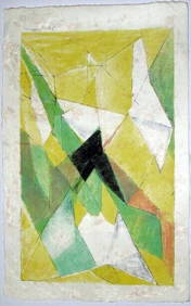
JAQUES VILLON (1875-1963) Hand Colored Cubist Lithograph ca1950Luis Porretta Fine Arts4.3(10)See Sold PriceMar 02, 2024
Persian Princess With Sword Bronze Sculpture on Marble Base FigurineHouse of Treasure4.4(50)See Sold PriceFeb 29, 2024
Persian Princess With Sword Bronze Sculpture on Marble Base FigurineKamy INC4.3(80)See Sold PriceFeb 29, 2024
Alexander Archipenko (American/Ukrainian, 1887-1964) - Walking WomanFreeman's | Hindman4.5(158)See Sold PriceFeb 27, 2024
Original 1994 'Speed' 35mm Film Movie Trailer/TeaserShakespeare Auctions4.3(1)See Sold PriceFeb 25, 2024
Richard Blow 20C Italian Pietra Dura Mosaic PlaqueHill Auction Gallery 4.7(1000)See Sold PriceFeb 28, 2024
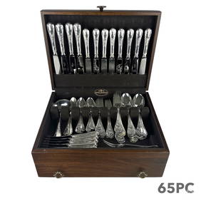
Christofle French Silverplate Marly Flatware SETHill Auction Gallery 4.7(1000)See Sold PriceFeb 28, 2024
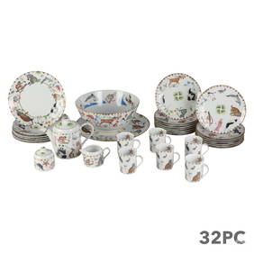
Lynn Chase Harmony Porcelain Table Service 32p SETHill Auction Gallery 4.7(1000)See Sold PriceFeb 28, 2024
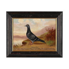
Andrew Beer (English, 1862-1954), Racing Pigeon Portrait, Swift and SureLeland Little4.5(686)See Sold PriceFeb 29, 2024
Bougainville's 1766 circumnavigation. France-Africa-Réunion. GENTS MAG 1774 mapJasper524.5(9.7k)See Sold PriceFeb 28, 2024
Bougainville's 1766 circumnavigation. France-Africa-Réunion. GENTS MAG 1774 mapJasper524.5(9.7k)See Sold PriceFeb 28, 2024
NORTH AFRICA. 'Biledulgerid', a former North African country. MALLET 1683 mapJasper524.5(9.7k)See Sold PriceFeb 28, 2024
Framed Vintage Map Of Le Port Au Prince In The Island Of Santo DomingoRapid Estate Liquidators and Auction Gallery4.5(1.1k)See Sold PriceMar 01, 2024
Herb Ritts, Richard Gere and Ileane (three works)Los Angeles Modern Auctions4.4(24)See Sold PriceMar 08, 2024


![Vintage Airplane Desk Model [Air France] (1 of 7)](https://p1.liveauctioneers.com/5755/320282/172113951_1_x.jpg?height=282&quality=70&version=1708463029)

