SoldHERMAN MOLL ENGRAVING, NEW MAP OF GREAT BRITAINHERMAN MOLL (DUTCH 1654-1732), HAND COLORED ENGRAVING, " A NEW MAP OF GREAT BRITAIN" 40" X 24" SIGHT:"A New Map of Great Britain, According to the Newest and Most Exact Observations By Herman Moll GeoSee Sold Price
SoldHerman Moll, (Dutch 1654-1732), The Empire of ChiHerman Moll (Dutch 1654-1732) The Empire of China and Island of Japan Agreeable to Modern History engraved map 10 1/2 x 10 1/4 inches.See Sold Price
SoldHerman Moll, (Dutch, 1654-1732), An engraved mapHerman Moll (Dutch, 1654-1732) An engraved map of Mexico or New Spain, Florida now called Louisiana and part of California, together with an engraved map of North America. 7 1/2 x 10 1/4 inches.See Sold Price
Map of Port Royal Harbor, SouthCarolina "A. Plan of Port Royal Harbor in Carolina with the proposed forts, depth of water & latitude...", after Herman Moll, Dutch, 1654-1732, 42 original drafts by Herman Moll, published in London bSee Sold Price
SoldHerman Moll (Dutch/English, 1654-1732)Herman Moll (Dutch/English, 1654-1732), "...Map of North America, According to ye Newest and most Exact Observations...", c. 1719, London, engraved copperplate map, on two joined sheets, in hand-colorSee Sold Price
SoldHerman Moll (1654 - 1732) The Turkish Empire in EuroHerman Moll (1654 - 1732) The Turkish Empire in Europe, Asia and Africa Copper engraving, two sheets, mounted on a canvas and watercolored in a later date 600x1000 mm. (defects) IT The Turkish EmpireSee Sold Price
SoldHerman Moll (1654? - 1732), by, The North Part of GreatHerman Moll (1654? - 1732), by, The North Part of Great Britain called Scotland, With Considerable Inprovements (sic) and many Remarks not Extant in any Map, According to the Newest and Exact ObservatSee Sold Price
SoldLocal Interest - Herman Moll (1654 - 1732), by andLocal Interest - Herman Moll (1654 - 1732), by and after, a map, Derby Shire (sic, Derbyshire), inset named-views of Pooles Hole (sic) and The Devils Arse (sic) to margin, with fossils and geologicalSee Sold Price
SoldCarolina & Bermuda 1716Map Title: Carolina & The Island Bermudos Maker: Herman Moll Date: 1716 Origin: Atlas Geographicus Size: 13 x 16 inches Medium: Copperplate engraving Herman Moll (1654-1732) was a London cartographer,See Sold Price
SoldAmerica by Herman Moll 1716Map Title: America, According to the Newest and Most Exact Observations Maker: Herman Moll Date: 1716 Origin: Atlas Geographicus Size: 13 x 16 inches Medium: Copperplate engraving Herman Moll (1654-17See Sold Price
SoldHerman Moll 1654-1732), "A New And Correct Map of theHerman Moll 1654-1732), "A New And Correct Map of the World," 1710, hand colored, H. - 22 in., W. - 38 in.See Sold Price
SoldHerman Moll (1654-1732), hand colored engraving mapHerman Moll (1654-1732), hand colored engraving map "A New and Correct Map of the WHOLE WORLD, Showing Y. e situation of its principal parts viz the oceans, Kingdoms, rivers, capes, ports, mountainsSee Sold Price
SoldTwo American Maps, H. Moll & Bellin, 1695 and 1757Grouping of two maps of America including, Item 1: Herman Moll (1654 -1732) "A Map of the English Plantations in America." Depicts the Americas from New England to South America. Published London, 169See Sold Price
SoldHerman Moll (1654-1732), London cartographer engraverHerman Moll (1654-1732), London cartographer engraver and publisher, A Map of the East Indies and the adjacent countries, with the settlements, factories and territories explaining what belongs to EngSee Sold Price
SoldMoll - Correct Map of the Whole World, 1719Herman Moll (1654?-1732), cartographer and publisher A New & Correct Map of the Whole World Shewing y.e Situation of its Principal Parts. Viz the Oceans, Kingdoms, Rivers, Capes, Ports, Mountains, WooSee Sold Price
SoldHerman Moll (1654-1732), "A New Map of Newfoundland,Herman Moll (1654-1732), "A New Map of Newfoundland, New Scotland..fishing banks," c. 1725, H. - 9 in., W. - 13 1/2 in.See Sold Price
SoldDenmark, Herman Moll 1700Title: Denmark Subject: Denmark Maker: Herman Moll Date: 1700 Materials: Hand colored copperplate engraving Size: 7.5 x 10.5 inches Herman Moll (1654-1732) was a London cartographer, engraver, and pubSee Sold Price
SoldGrp: 3 Maps of EuropeGroup of three maps of Europe. Includes one hand colored map of the Netherlands by Herman Moll (1654-1732), "A New Map of the United Provinces of Netherlands &c." London: Herman Moll, ca. 1701; one DuSee Sold Price
Map of the Island of Jamaica by Herman MollMap: A New Map of the Island of Jamaica Maker: Herman Moll Size: Double Octavo - 7 inches high x 10.1 inches wide Date: 1716 "By H. Moll, geographer." Herman Moll (1654-1732) was a London cartographerSee Sold Price
SoldMoll Engraved Map of AmericaA new map of the north parts of America claimed by France under ye names of Louisiana, Mississipi, Canada, and New France with ye adjoining territories of England and Spain. Herman Moll (1654-1732). ESee Sold Price
SoldSCARCE C.1720 MAP, NORTH AMERICA, MOLL, COD FISHFramed map, Herman Moll (1654-1732) "John, Lord Sommers...Map of North America", also known as the "Cod Fish Map", hand colored, c. 1720, western North America shown as "Parts Unknown", California shoSee Sold Price
SoldHerman Moll (1654-1732)Herman Moll (1654-1732), "To the Right Honourable John Lord Sommers...this Map of North America according to ye newest and most exact observations...", London, "Printed for I. Bowles... T. Bowles... PSee Sold Price
SoldHerman Moll (1654-1732) - A New and correct map of theHerman Moll (1654-1732) A New and Correct map of the Whole World, engraving 1719, on joined sheets with old folds, some hand-colouring, 71 x 120cm (visible)See Sold Price
SoldHerman Moll Map of South America, c.1711-1730A New and Exact Map of the Coast, Countries and Islands within the limits of the South Sea Company, by Herman Moll (1654-1732), copperplate engraving with hand coloring, (likely later). London, 1711.See Sold Price
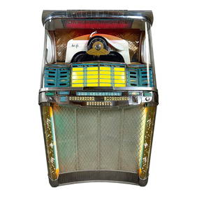
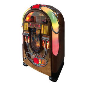
1946-1947 Wurlitzer Model 1015 "The Bubbler" JukeboxDutch Auction Company4.3(2)See Sold PriceFeb 24, 2024
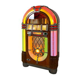
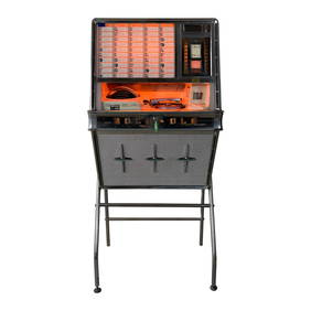
1961 Rock-Ola 1484 Wall Phonograph with Original StandDutch Auction Company4.3(2)See Sold PriceFeb 24, 2024
JAN VAN DER DESYATER c1732 First Edition Thoughts On Sleepless Nights Rare!Luis Porretta Fine Arts4.3(10)See Sold PriceMar 02, 2024
Paulus Potter Dutch 1625-1654 Etching The Plough Horse 3rd StateGlobal Auctions Company4.3(36)See Sold PriceMar 03, 2024
An early Dutch hand colored engraving map by Georg Balthasar Probst (1732-1801)Ostantix Auctions4.4(10)See Sold PriceFeb 27, 2024
1762 Commentarius ad Psalmos by HERMAN VENEMA antique VELLUM BINDINGJasper524.5(9.8k)See Sold PriceFeb 27, 2024
1732 BIBLE BIBLIA NEERLANDICA antique OLD & NEW TESTAMENT NETHERLANDS DUTCHJasper524.5(9.8k)See Sold PriceFeb 27, 2024
1765 Commentary on Prophet Jeremia by HERMAN VENEMA antique VELLUM BINDING V. IJasper524.5(9.8k)See Sold PriceFeb 27, 2024
RONALD CHAPEAU - SOPHIA LOREN - ORIGINALArtMeetsStreet x Mercer Auctions4.4(44)See Sold PriceMar 02, 2024
Cows Crossing Stream with Driver, P. PotterBroken Arch Auction Gallery NCFL#93994.6(294)See Sold PriceMar 04, 2024
Continental Renaissance Hand Painted Oval Leaded and Stained Glass PanelBrunk Auctions4.6(463)See Sold PriceMar 07, 2024
COMMENTARIUS AD PSALMOS, HERMAN VENEMA, 1766; OLD LATIN VELLUM BINDINGNY Elizabeth 4.3(84)See Sold PriceMar 03, 2024
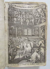
1732 ANTIQUE VELLUM ALMANACHS HEILIGEN ANTIQUE ANTI-PAMPHLET WORK BY MAGYRUSNY Elizabeth 4.3(84)See Sold PriceMar 03, 2024
Herman Moll A New Map of Ye North Parts of AmericaWillow Auction House4.5(283)See Sold PriceMar 14, 2024