ATLAS of ANTIENT GEOGRAPHY by SAMUEL BUTLER 1843John McInnis Auctioneers,LLC4.6(502)See Sold PriceFeb 24, 2024
18TH C. ANTIQUE MAP: FRENCH & INDIAN WAR, FRAMEDThomaston Place Auction Galleries4.4(386)See Sold PriceFeb 24, 2024
Rand McNally Railroad Map Cabinet w/ 21 Railroad MapsRail & Road Auctions4.6(165)See Sold PriceMar 08, 2024
Keith Haring - Ink on New York Map, Best Buddies, Inscribed, Signed, and DatedSapphire Auction Gallery4(67)See Sold PriceMar 02, 2024
LATE 17TH C. FRENCH MAP OF THE NEW WORLD BY ALEXIS-HUBERT JAILLOT (1632-1712)Thomaston Place Auction Galleries4.4(386)See Sold PriceFeb 24, 2024
Central Railroad of New Jersey Map of Sandy Hook Route-ca. 1903JM Hobby Supply and Railroad Artifact Auctions4.4(126)See Sold PriceFeb 24, 2024
Lot of Six Mixed Atlas Box Cars-HO Scale-New in BoxJM Hobby Supply and Railroad Artifact Auctions4.4(126)See Sold PriceFeb 25, 2024
Rand McNally/Santa Fe Railroad Map of Iowa-1912JM Hobby Supply and Railroad Artifact Auctions4.4(126)See Sold PriceFeb 24, 2024
NICOLAES VISSCHER (NETHERLANDS, 1618-1709) MAP OF THE NEW WORLDThomaston Place Auction Galleries4.4(386)See Sold PriceFeb 24, 2024
17TH C. WORLD MAP BY NICOLAES VISSCHER (NETHERLANDS, 1618-1709)Thomaston Place Auction Galleries4.4(386)See Sold PriceFeb 24, 2024
Lot of Six Mixed Atlas Cabooses-HO Scale-New in BoxJM Hobby Supply and Railroad Artifact Auctions4.4(126)See Sold PriceFeb 25, 2024
Hall: Map of Greece, 1830Map: Greece Maker: Sydney Hall Publisher: Longman, Orm & Co. Published: 1930 in London Size: Folio, 19.8 x 16.3 inches Sydney Hall (1818-1860) worked as a map maker at a time when the demand for highlSee Sold Price
SoldSidney Hall: Map of Greece, 1830Map: Greece Publication Date: 1830 ca. Authors: LONGMAN, ORM & CO., HALL, SYDNEY Publisher: LONGMAN, ORM & CO. Size: Folio – 19.80 H x 16.30 W Inches Extremely detailed. Attractive color. Margins reSee Sold Price
Victor Lavasseur. Map of Greece. 1830.Print of hand colored steel engraving titled Grece et Republique lonienne“.Author Victor Lavasseur.Engraved by unknown.From Atlas classique universel de Geographie anciene et moderne“ by Victor LeSee Sold Price
SoldSydney Hall: Map of Persia, 1830Map of Persia. Longman, Orme & Co., Hall, Sidney, 1830, London. Folio - 16.30 H x 20.00 W Inches, Scarce atlas map with beautiful color. Covers Iraq, Iran, Afghanistan region. Dry with margin repair.See Sold Price
SoldSidney Hall: Map of Africa, 1830Map: Africa. Date: 1830 Authors: LONGMAN, REES, ORME, BROWN AND GREEN, HALL, SIDNEY Publisher: LONGMAN, REES, ORME, BROWN AND GREEN 1830 LONDON Size: Folio – 20.10 H x 16.60 W Inches Polar projectioSee Sold Price
SoldSidney Hall: Map of Hindoostan, 1830Map: Hindoostan. Maker: Longman, Rees, Orme, Brown and Green, Hall, Sidney Publication Date: 1830 Publisher: Longman, Rees, Orme, Brown and Green Size: Folio – 20.00 H x 16.00 W Inches Polar projectSee Sold Price
SoldSidney Hall: Map of Persia, 1830Map: Persia. Maker: Longman, Rees, Orme, Brown and Green, Hall, Sidney Publication Date: 1830 Publisher: Longman, Rees, Orme, Brown and Green Size: Folio – 19.75 H x 16.25 W Inches Polar projection.See Sold Price
Sidney Hall: Map of Egypt, 1830Map: Egypt. Maker: Longman, Rees, Orme, Brown and Green, Hall, Sidney Publication Date: 1830 Publisher: Longman, Rees, Orme, Brown and GreenSize: Folio – 20.10 H x 16.50 W Inches Water stains PleaseSee Sold Price
SoldSidney Hall: Antique Map of Europe, 1830Map: Europe Publication Date: 1830 Authors: LONGMAN, REES, ORME, BROWN AND GREEN, HALL, SIDNEY Publisher: LONGMAN, REES, ORME, BROWN AND GREEN Size: Folio – 16.25 H x 20.00 W Inches Polar projectionSee Sold Price
Sidney Hall: Map of British Isles, 1830Map: British Isles Publication Date: 1830 Author: LONGMAN, REES, ORME, BROWN AND GREEN, HALL, SIDNEY Publisher: LONGMAN, REES, ORME, BROWN AND GREEN Size: Folio – 20.25 H x 16.30 W Inches Please notSee Sold Price
Sidney Hall: Map of Northern Africa 1830Map: Northern Africa Maker: Longman, Rees, Orme, Brown and Green, Hall, Sidney Publication Date: 1830 Publisher: Longman, Rees, Orme, Brown and Green Size: Folio – 16.50 H x 20.00 W Inches Water staSee Sold Price
Hall: Antique Map of Asia, 1830Title/Content of Map: Asia Cartographer: HALL, SIDNEY Size: 16.5X19.75 Polar projection. Please note that this lot has a confidential reserve. When you leave a bid in advance of the auction, submit yoSee Sold Price
Sydney Hall: Map of Sweden & Norway, 1830Map: Sweden and Norway. Publication Date: 1830 Author: LONGMAN, ORME & CO., HALL, SYDNEY Publisher: LONGMAN, ORME & CO. Size: Elephant Folio – 19.75 H x 16.25 W Inches Please note that this lot hasSee Sold Price
Hall: Map of Sweden and Norway, 1830Map: Sweden and Norway Maker: Sydney Hall Publisher: Longman, Orme & Co. Published: 1830 in London Size: Elephant Folio, 19.75 x 16.25 inches Sydney Hall (1818-1860) worked as a map maker at a time whSee Sold Price
Sydney Hall: Map of Turkey in Europe, 1830Map: Turkey in Europe. Publication Date: 1830 Authors: LONGMAN, REES, ORME, BROWN AND GREEN, HALL, SIDNEY Publisher: LONGMAN, REES, ORME, BROWN AND GREEN Size: Folio – 20.00 H x 16.10 W Inches PolarSee Sold Price
Sidney Hall: Antique Map of Hellas or Greece, 1856Title/Content of Map: 'Hellas or Greece [inset: Corfu (Kopkypa-Corcyra)]' Ionian, Cyclades & Aegean islands. Date Printed: 1856 Image Size: Approx 31.5 x 42.5cm, 12.5 x 16.75 inches (Large) Type: AntiSee Sold Price
Hall: Antique Map of Hellas or Greece, 1856TITLE/CONTENT OF MAP: 'Hellas or Greece [inset: Corfu (Kopkypa-Corcyra)]' DATE PRINTED: 1856 IMAGE SIZE: Approx 31.5 x 42.5cm, 12.5 x 16.75 inches (Large) TYPE: Antique atlas map with original hand coSee Sold Price
Hall: Antique County Map of Middlesex, 1830TITLE/CONTENT OF MAP: 'Middlesex' DATE PRINTED: c1830 IMAGE SIZE: Approx 20.0 x 26.0cm, 7.75 x 10 inches (Medium); Please note that this is a folding map. TYPE: Antique hand coloured steel engraved maSee Sold Price
Sidney Hall: Map of New Brunswick & Nova Scotia, 1830Map: Canada, New Brunswick and Nova Scotia. Eastern Canada with North West Territory in U. S. Publication Date: 1830 Author: LONGMAN, REES, ORME, BROWN AND GREEN, HALL, SIDNEY Publisher: LONGMAN, REESSee Sold Price
Sidney Hall: Antique Map of Turkey in Europe, 1830Map: Turkey in Europe. Publication Date: 1830 Authors: LONGMAN, REES, ORME, BROWN AND GREEN, HALL, SIDNEY Publisher: LONGMAN, REES, ORME, BROWN AND GREEN Size: Folio – 20.00 H x 16.10 W Inches PolarSee Sold Price
Hall: Antique Map of British North America, 1830Title/Content of Map: British North America Date Printed: 1830 Cartographer: HALL, SIDNEY Size: 16.5X20 Polar projection. Please note that this lot has a confidential reserve. When you leave a bid inSee Sold Price
Sidney Hall: Antique Map of British North America, 1830Map: British North America Publication Date: 1830 Authors: LONGMAN, REES, ORME, BROWN AND GREEN, HALL, SIDNEY Publisher: LONGMAN, REES, ORME, BROWN AND GREEN Size: Folio – 16.50 H x 20.00 W Inches PSee Sold Price
SoldTravels In N. America In1827-28, hand colored map, 1830Title: Travels In North America, In The Years 1827 And 1828 Provenance: IN THREE VOLUMES, 1830, with large hand colored folding map of United States and Canada showing Capt. Hall's route. [HOWES H 47]See Sold Price
SoldSidney Hall Map of Devonshire PrintFramed and matted print of the Sidney Hall engraving "Map of Devonshire" Devon County, England circa 1830. Gilt frame measures 18-1/4" in height by 22-1/4" in width with the sight image measuring 7-3/See Sold Price
PIETER SCHENK / VALK / JANSSEN Hand Colored Map of Rhodes Greece ca1702 vgcLuis Porretta Fine Arts4.3(10)See Sold PriceMar 02, 2024
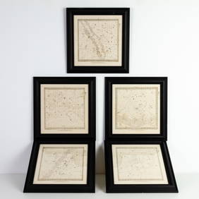
Set of Five Astronomical Zodiac Maps of the Stars by Baldwin & Gradock 1830Passion For Antiques3.9(23)See Sold PriceFeb 25, 2024
Mckenney & Hall - Two Octavo Volumes of Text with Rare Plate of Billy BowlegsTrillium Antique Prints & Rare Books4.5(30)See Sold PriceFeb 24, 2024
McKenney & Hall, Folio, Rare - Hunting the BuffaloeTrillium Antique Prints & Rare Books4.5(30)See Sold PriceFeb 24, 2024
Northern & Southern Africa. Maghreb. Orange River Sovereignty. HALL 1854 mapJasper524.5(9.8k)See Sold PriceFeb 28, 2024
NORTH AFRICA BARBARY. Parts of Tripoli (Libya) & Egypt. Tribes. SDUK 1844 mapJasper524.5(9.8k)See Sold PriceFeb 28, 2024
Early colonial Africa. Inset Madeira & Aden. SIDNEY HALL 1856 old antique mapJasper524.5(9.8k)See Sold PriceFeb 28, 2024
Northern & Southern Africa. Maghreb. Orange River Sovereignty. HALL 1856 mapJasper524.5(9.8k)See Sold PriceFeb 28, 2024
ANCIENT NORTH AFRICA. Greek colonies. "La Libye, L'Egypte…". TARDIEU 1830 mapJasper524.5(9.8k)See Sold PriceFeb 28, 2024
NIGERIA early explorers' routes. Lake Chad. Yariba Houssa Borgou SDUK 1844 mapJasper524.5(9.8k)See Sold PriceFeb 28, 2024
Early colonial Africa. Inset Madeira & Aden. SIDNEY HALL 1854 old antique mapJasper524.5(9.8k)See Sold PriceFeb 28, 2024
NIGERIA w/ early explorers' routes. Lake Chad Yariba Houssa Borgou.SDUK 1844 mapJasper524.5(9.8k)See Sold PriceFeb 28, 2024
Barthelemy, Jean 1790 Map. Greece - Essa sur la Bataille de PlateeAlbion Auctions4.6(336)See Sold PriceMar 01, 2024
Barthelemy, Jean 1790 Map. Greece - Plan de L'AcademieAlbion Auctions4.6(336)See Sold PriceMar 01, 2024
Barthelemy, Jean 1790 Map. Greece - Essai sur les Environs de DelphesAlbion Auctions4.6(336)See Sold PriceMar 01, 2024