ATLAS of ANTIENT GEOGRAPHY by SAMUEL BUTLER 1843John McInnis Auctioneers,LLC4.6(502)See Sold PriceFeb 24, 2024
18TH C. ANTIQUE MAP: FRENCH & INDIAN WAR, FRAMEDThomaston Place Auction Galleries4.4(386)See Sold PriceFeb 24, 2024
Rand McNally Railroad Map Cabinet w/ 21 Railroad MapsRail & Road Auctions4.6(165)See Sold PriceMar 08, 2024
Keith Haring - Ink on New York Map, Best Buddies, Inscribed, Signed, and DatedSapphire Auction Gallery4(67)See Sold PriceMar 02, 2024
LATE 17TH C. FRENCH MAP OF THE NEW WORLD BY ALEXIS-HUBERT JAILLOT (1632-1712)Thomaston Place Auction Galleries4.4(386)See Sold PriceFeb 24, 2024
Central Railroad of New Jersey Map of Sandy Hook Route-ca. 1903JM Hobby Supply and Railroad Artifact Auctions4.4(126)See Sold PriceFeb 24, 2024
Lot of Six Mixed Atlas Box Cars-HO Scale-New in BoxJM Hobby Supply and Railroad Artifact Auctions4.4(126)See Sold PriceFeb 25, 2024
Rand McNally/Santa Fe Railroad Map of Iowa-1912JM Hobby Supply and Railroad Artifact Auctions4.4(126)See Sold PriceFeb 24, 2024
NICOLAES VISSCHER (NETHERLANDS, 1618-1709) MAP OF THE NEW WORLDThomaston Place Auction Galleries4.4(386)See Sold PriceFeb 24, 2024
17TH C. WORLD MAP BY NICOLAES VISSCHER (NETHERLANDS, 1618-1709)Thomaston Place Auction Galleries4.4(386)See Sold PriceFeb 24, 2024
Lot of Six Mixed Atlas Cabooses-HO Scale-New in BoxJM Hobby Supply and Railroad Artifact Auctions4.4(126)See Sold PriceFeb 25, 2024
SoldGrp: 6 Maps of Europe by Braun & HogenbergGroup of six maps by Georg Braun (1541–1622) and Frans Hogenberg (1540–1590) including maps of Ghent, Odense in Denmark originally for the book "Civitates Orbis Terrarum", a map of ParisSee Sold Price
Sold5 vols. Cartography - European City & County Maps5 vols. Cartography - European City & County Maps: Goss, John. Braun & Hogenberg's The City Maps of Europe: A Selection... London: Studio, (1991). Folio, orig. cloth, d/j. Color plates. * The 1992 RanSee Sold Price
16th Century Town Plans from Braun & HogenbergTitle: The City Maps of Europe. 16th Century Town Plans from Braun & Hogenberg Chicago. Rand McNally. 1991 Author(s): Goss, John First edition. Condition: Fine copy in fine dust jacket (in mylar). FolSee Sold Price
SoldBraun & Hogenberg. COLDING SCHLOSS UND STAT.[Europe/Denmark]. Braun & Hogenberg. COLDING SCHLOSS UND STAT. Double-page engraved map, contemporary hand-coloring, tiny tear to lower edge of sheet, full margins. 13 ¾ x 18 ¾ inches. View of KoldiSee Sold Price
Sold1581 Braun and Hogenberg View of Luxembourg --Title/Content of Map: 1581 Braun and Hogenberg View of Luxembourg -- Lutzenburgum, Ducatus eiusdem Nominis, Vetus et Primaria Urbs… Date: 1581 c., Koln Cartographer: Braun and Hogenberg Size: 13.6 XSee Sold Price
Braun & Hogenberg Map of Edinburgh*** START PRICE IS THE RESERVE *** [Europe] BRAUN, Georg (1541-1622) & HOGENBERG, Frans (1535-1590). Edenburg (Edinburgh, Scotland). Engraving with original hand color. Cologne: 1572-1618 from CivitatSee Sold Price
Sold6 maps. Copper engravings. Old colored. Prints.Georges BRAUN (1541 - 1622). 35,5 cm x 41 cm der Ausschnitt. Altkolorierter Kupferstich von Georg Braun (1541 - 1622) und Hogenberg aus Civitates orbis Terrarum III, 41, 1583. Titel " Neue SächsiSee Sold Price
1574 Mediolanum.By: Georg Braun and Franz Hogenberg Date: 1574 (Published) Cologne Dimensions: 13 x 18.75 inches (33 x 47.6 cm) This map presents one of the earliest obtainable bird’s eye views of the great city ofSee Sold Price
Sold1574 Argentoratum (Strasbourg)By: Georg Braun and Franz HogenbergDate: 1574 (Published) CologneDimensions: 13.25 x 16.6 inches (33.7 x 42.2 cm)This Braun and Hogenberg map of Strasbourg is from the second edition of their monumentSee Sold Price
1574 Messana.By: Georg Braun and Franz Hogenberg Date: 1574 (Published) Cologne Dimensions: 13.25 x 18.75 inches (33.7 x 47.6 cm) This map presents one of the earliest obtainable bird’s eye views of the strategiSee Sold Price
1574 Ancona.By: Georg Braun and Franz Hogenberg Date: 1574 (Published) Cologne Dimensions: 13 x 18.75 inches (33 x 47.6 cm) This map presents one of the earliest obtainable bird’s eye views of the ancient ItaliSee Sold Price
1574 Amsterdam.By: Georg Braun and Franz Hogenberg Date: 1574 (Published) Cologne Dimensions: 13.25 x 19 inches (33.6 x 48.3 cm) This important early map of Amsterdam is from Braun and Hogenberg’s important work CSee Sold Price
SoldBraun & Hogenberg. Civitates orbis terrarumBraun (Georg) and Franz Hogenberg. Civitates orbis terrarum,6 vol., engraved titles, 363 engraved city-views, plates and maps on 362 sheets, 3 folding (Antwerp, Rome and Cracow), the rest doubSee Sold Price
SoldBraun Hogenberg Civitates Orbis 1966Braun (Georg) and Franz Hogenberg. Civitates Orbis Terrarum, 6 parts in 3 vol., facsimile reprint of the Antwerp & Cologne edition of 1572-1618 with introduction by R.A.Skelton, double-page maSee Sold Price
1581 Braun & Hogenberg View of Luxembourg -- LuxembourgTitle: 1581 Braun & Hogenberg View of Luxembourg -- Luxembourg Cartographer: Braun & Hogenberg Year / Place: 1581 c., Koln Map Dimension (in.): 13.6 X 16.5 in. This is a rather handsome double-page viSee Sold Price
1581 Braun & Hogenberg View of Luxembourg -- LuxembourgTitle: 1581 Braun & Hogenberg View of Luxembourg -- Luxembourg Cartographer: Braun & Hogenberg Year / Place: 1581 c., Koln Map Dimension (in.): 13.6 X 16.5 in. This is a rather handsome double-page viSee Sold Price
Sold1574 Lubec [and] Hamburch Ein Vorneliche Hanse Stat.By: Georg Braun and Franz Hogenberg Date: 1574 (Published) Cologne Dimensions: 12.6 x 18.4 inches (32 x 46.74 cm) These engravings are from an early edition of Braun & Hogenberg's Civitates Orbis TerrSee Sold Price
1582 Braun and Hogenberg View of Mantua Italy -- MantuaTitle: 1582 Braun and Hogenberg View of Mantua Italy -- Mantua Cartographer: Braun and Hogenberg Year / Place: 1582 c., Koln Map Dimension (in.): 13.9 X 19.6 in. This superb bird's-eye view of MantuaSee Sold Price
1575 Braun and Hogenberg View of Spanish Granada -- Granada 1563Title: 1575 Braun and Hogenberg View of Spanish Granada -- Granada 1563 Cartographer: Braun and Hogenberg Year / Place: 1575, Koln Map Dimension (in.): 12.6 X 19.8 in. This is a magnificent view of thSee Sold Price
1582 Braun and Hogenberg View of Mantua Italy -- MantuaTitle: 1582 Braun and Hogenberg View of Mantua Italy -- Mantua Cartographer: Braun and Hogenberg Year / Place: 1582 c., Koln Map Dimension (in.): 13.9 X 19.6 in. This superb bird's-eye view of MantuaSee Sold Price
SoldGRP OF ROAD MAPSGRP OF ROAD MAPS TO INC: (6) FRANCE 1940'S MAPS BY MICHELIN; (9) ESSO/IMPERIAL MAPS OF CANADA, ITALY, ENGLAND, FRANCE, SWITZERLAND, & WESTERN EUROPE; (8) CANADIAN 1952, 1973, 1990-91 MAPS.See Sold Price
1574 Gandauum.By: Georg Braun and Franz Hogenberg Date: 1574 (Published) Cologne Dimensions: 13.25 x 18.75 inches (33.7 x 47.6 cm) This bird’s eye view is one of the earliest pictorial depictions of Ghent, the thSee Sold Price
SoldBirds-Eye View Map. Town Plan of Nuremberg.Published by Braun, C. 1575. Hand colored engraving by Hogenberg. One of 6 16th C. hand colored town maps from this collection. From a Manhattan, NYC estate. Dimensions: Image appx. 19.25" x 12". CondSee Sold Price
SoldBirds-Eye View Map. Town Plan of Schaebisch Hall& River Kocher (Suevia). Published by Braun C. 1580. Hand colored engraving by Hogenberg. One of 6 16th C. hand colored town maps from this collection. From a Manhattan, NYC estate. Dimensions: ImageSee Sold Price
1585 OXONIUM VINDESORIUM (OXFORD AND WINDSOR CASTLE) BY BRAUN AND HOGENBERG, FRAMEDThomaston Place Auction Galleries4.4(386)See Sold PriceFeb 24, 2024
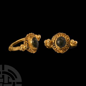
Roman Gold Ring with Amethyst Gemstone with Mercury and BacchusTimeLine Auctions Ltd.4.5(183)See Sold PriceMar 05, 2024
Late Roman or Merovingian Gold Ring with Rosette and Green CabochonTimeLine Auctions Ltd.4.5(183)See Sold PriceMar 05, 2024
Antique German Kampen Town Color Copper EtchingHill Auction Gallery 4.7(1k)See Sold PriceFeb 28, 2024
Two (2) Antique 18th C. Copper Engraved Framed Maps - America & EuropeMagnusson Art Group4.5(46)See Sold PriceMar 14, 2024
Carey, pub. 1796 - Map of GeorgiaTrillium Antique Prints & Rare Books4.5(30)See Sold PriceFeb 24, 2024
Carey, pub. 1796 - Map of The State of South CarolinaTrillium Antique Prints & Rare Books4.5(30)See Sold PriceFeb 24, 2024
Carey, pub. 1796 - Map of KentuckyTrillium Antique Prints & Rare Books4.5(30)See Sold PriceFeb 24, 2024
Carey, pub. 1796 - Map of the Tennassee State formerly part of North Carolina (Tennessee)Trillium Antique Prints & Rare Books4.5(30)See Sold PriceFeb 24, 2024
1704 DESCRIPTION OF ALL THE SEATS OF THE PRESENT WARS OF EUROPE antique w/ MAPSJasper524.5(9.8k)See Sold PriceFeb 27, 2024
Photography - Set of 10 CDV Photo - Portraits of PeopleProverde Auctions4.3(3)See Sold PriceFeb 28, 2024
Photography - Set of 10 CDV Photo - Portraits of Woman and ManProverde Auctions4.3(3)See Sold PriceFeb 28, 2024
Photography - Set of 10 CDV Photo - Portraits from EuropeProverde Auctions4.3(3)See Sold PriceFeb 28, 2024
Photography - Set of 20 CDV Photo - Portraits from EuropeProverde Auctions4.3(3)See Sold PriceFeb 28, 2024
Photography - Set of 20 CDV Photo - Portraits with Man and WomanProverde Auctions4.3(3)See Sold PriceFeb 28, 2024
Photography - Set of 20 CDV Photo - Portraits with Man and WomanProverde Auctions4.3(3)See Sold PriceFeb 28, 2024


![1574 Lubec [and] Hamburch Ein Vorneliche Hanse Stat. (1 of 1)](https://p1.liveauctioneers.com/5584/123034/62599786_1_x.jpg?height=282&quality=70&version=1528242937)