ATLAS of ANTIENT GEOGRAPHY by SAMUEL BUTLER 1843John McInnis Auctioneers,LLC4.5(505)See Sold PriceFeb 24, 2024
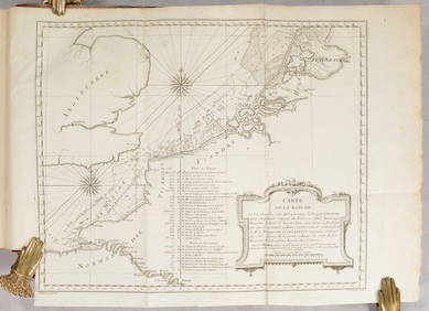
18TH C. ANTIQUE MAP: FRENCH & INDIAN WAR, FRAMEDThomaston Place Auction Galleries4.4(393)See Sold PriceFeb 24, 2024
Rand McNally Railroad Map Cabinet w/ 21 Railroad MapsRail & Road Auctions4.6(165)See Sold PriceMar 08, 2024
Keith Haring - Ink on New York Map, Best Buddies, Inscribed, Signed, and DatedSapphire Auction Gallery4.1(67)See Sold PriceMar 02, 2024
LATE 17TH C. FRENCH MAP OF THE NEW WORLD BY ALEXIS-HUBERT JAILLOT (1632-1712)Thomaston Place Auction Galleries4.4(393)See Sold PriceFeb 24, 2024
Central Railroad of New Jersey Map of Sandy Hook Route-ca. 1903JM Hobby Supply and Railroad Artifact Auctions4.4(127)See Sold PriceFeb 24, 2024
Lot of Six Mixed Atlas Box Cars-HO Scale-New in BoxJM Hobby Supply and Railroad Artifact Auctions4.4(127)See Sold PriceFeb 25, 2024
Rand McNally/Santa Fe Railroad Map of Iowa-1912JM Hobby Supply and Railroad Artifact Auctions4.4(127)See Sold PriceFeb 24, 2024
NICOLAES VISSCHER (NETHERLANDS, 1618-1709) MAP OF THE NEW WORLDThomaston Place Auction Galleries4.4(393)See Sold PriceFeb 24, 2024
17TH C. WORLD MAP BY NICOLAES VISSCHER (NETHERLANDS, 1618-1709)Thomaston Place Auction Galleries4.4(393)See Sold PriceFeb 24, 2024
Lot of Six Mixed Atlas Cabooses-HO Scale-New in BoxJM Hobby Supply and Railroad Artifact Auctions4.4(127)See Sold PriceFeb 25, 2024
SoldGrp: 20 Books on U.S. Maps and ExplorationGroup of 20 books on U.S. maps and exploration. Includes "The Exploration of North America, 1630-1776;" "Dr. John Mitchell: The Man Who Made The Map of North America;" "A List of Maps of America in thSee Sold Price
SoldGrp: Books on the Eastern U.S.Group of books and maps on the Eastern United States. Includes The John Henry County Map of Virginia 1770 by Louis B. Wright (two copies); Tidewater Towns: City Planning in Colonial Virginia and MarylSee Sold Price
Sold1872 book w/ 20 nautical maps: Central America.[Nautical Maps]. Robert W. Shufeldt. Reports Of Explorations And Surveys, To Ascertain the Practicability of a Ship-Canal between the Atlantic and Pacific Oceans, by Way of the Isthmus of Tehuantepec.See Sold Price
Sold1887 Jules Verne Famous Travels & Travelers Voyage1887 Jules Verne Famous Travels & Travelers Voyage Exploration Illustrated MAPS “Reality provides us with facts so romantic that imagination itself could add nothing to them.” ― Jules VerneSee Sold Price
US Map Bed TrayUS Map Bed Tray ca. 1950 masonite/metal/paper 20" W x 9.75" D x 13.25" H Vintage bed tray with folding metal legs, book holders, and map of the United States. Manufactured by Replogle Globes of ChicagSee Sold Price
SoldGrp: 47 Books on California NW Coast and SouthernGroup of 47 books about California and the southern US, including The Northern Pacific Main Street of the Northwest by Charles R. Wood; The History of San Diego: The Explorers. Volume 1 of a planned sSee Sold Price
Grp 6 Books on European ExplorationGroup of six books about European exploration. Includes "The Memoirs and Travels of Sir John Reresby, Bart.," London, 1813; "Colomb dans les fers, a Ferdinand et Isabelle," London, 1782; "An AbridgmenSee Sold Price
Sold6 19TH CENT NONFICTION EXPLORATION & MEMOIR BOOKSLot of historical nonfiction books includes: US presidential memoirs and exploration recounts, "Three Years of Arctic Service Volume 1" (Lady Franklin Bay Expedition Greely, Vol. I 1883), "The VoyageSee Sold Price
SoldLot of 20 Military Related Books1. First edition, HIROSHIMA, John Hersey, 1946---2. FIX BAYONETS!, John W. Thomason Jr., Captain, U.S. Marine Corps, 1926---3. RUSSIA AND JAPAN AND A COMPLETE HISTORY OF THE WAR IN THE FAR EAST, FredeSee Sold Price
MAPS IN BOOKS - Exploration & SurveysExploration & Surveys. U.S. Railroad Surveys, [13 Volumes] Reports of Explorations and Surveys, to Ascertain the Most Practicable and Economical Route for a Railroad from the Mississippi River to theSee Sold Price
SoldWinfield S Schley REPORT OF WINFIELD S SCHLEY COMMANDERWinfield S Schley REPORT OF WINFIELD S SCHLEY COMMANDER US NAVY COMMANDING GREELEY RELIEF EXPEDITION OF 1884 1887 Antique Illustrated Plates Maps Polar Arctic Exploration Lady Franklin Bay Adolphus GrSee Sold Price
Colorado AtlasCO - 1881 - Large (26.5 by 20 inches) publication by U.S. Government Geologist F.V. Hayden, of maps and sketches from Colorado and the adjacent territories. Book was approved by an act of Congress onSee Sold Price
Map Exhibiting the Lines of March… 1858U.S. Army on the March in Peacetime 147. [MAP]. UNITED STATES. WAR DEPARTMENT. OFFICE OF EXPLORATIONS & SURVEYS. FLOYD, J[ohn] B. Map Exhibiting the Lines of March Passed over by the Troops of theSee Sold Price
Sold2 Books incl: Stansbury. EXPLORATION... GREAT SALT[Western US]. 2 Titles. ++ J. W. Foster and J. D. Whitney. REPORT ON THE GEOLOGY OF THE LAKE SUPERIOR LAND DISTRICT. Part II. Wash: A. Boyd Hamilton, 1851. 37 plates (incl 2 plates XVIII carrying theSee Sold Price
MAP IN BOOK, Arizona, ParkeArizona. Lt. John G. Parke, Map No. 2 From the Pimas Villages to Fort Fillmore from Explorations and Surveys Made Under the Direction of the Hon. Jefferson Davis, Secretary of War..., from U.S. PacifiSee Sold Price
Sold8 books, Map & explorations[Reference/Exploration]. 7 Titles (8 Vols). Vp:vp. 8vo/4to. Hardover (4 in dj). Very Good. ++ Joseph Cottler and H. Jaffe. Map Makers. 1937. ++ Antique Map Price Record & Handbook For... 1987, 1993. 2See Sold Price
(20) Books On Exploration, Space, & TravelTo include first editions: " The Adventures of Marco Polo," illustrated, The John Day Company 1948, former owners name written in ink on the inside cover, otherwise in very good condition, with slightSee Sold Price
SoldUS Geological Survey Map of the United StatesVery large book of US maps, from the whole country. All color topographical maps, featuring quadrant sections. This book measures 28"x19", and has railroads indicated on the maps. These maps are detaiSee Sold Price
Sold2 maps: ''Rio Colorado of the West'' 1858, pub. 1[Western US]. 2 Maps. Explorations And Surveys. War Department. Map Nos. 1-2. Rio Colorado Of The West. Drawn by F. W. von Egloffstein. 1858. From: Report Upon The Colorado River Of The West, ExploredSee Sold Price
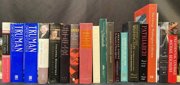
Sold(20) BOOKS: BIOGRAPHIES OF U.S. PRESIDENTS(lot of 20) Books: biographies of U.S. Presidents, including: (5) "Dark Horse," (5) "A Collection of the Facts and Documents Relative to the Death of Major General Alexander Hamilton," "Jefferson andSee Sold Price
Grp: 9 Books and Maps about Europe and FranceGroup of books and maps about Europe, particularly focusing on France. Includes A. Hugo, "France Pittoresque ou Description Pittoresque, Topographique et Statitique Des Departements et colonies De LaSee Sold Price
SoldLot of 20 U.S land survey maps, 1866-1882Title: Lot of 20 U.S land survey maps, 1866-1882 Author: Wilson, Joseph, et al. Description: With: Map of the United States & Territories, northeastern portion missing, horizontally split in two, otheSee Sold Price
Grp: 22 Books and Maps Related to FranceGroup of books and maps about France. Includes "Conseil a la France Desolee" Sebastien Castellion; "Wines of France" 1977 (calendar planner); "The Little Tour of France" Henry James; "Fables de la FonSee Sold Price
Sold20 miniature books from US publishersTitle: 20 miniature volumes published in the United States Author: ** Description: Includes: Secret (The Little Red Hen). Wrappers. 1 of 75 copies. Book written entirely in numerical code. When decodeSee Sold Price
Delaware and Hudson RR International Holidays Book-1912JM Hobby Supply and Railroad Artifact Auctions4.4(127)See Sold PriceFeb 24, 2024
FRANK MARMINGTON c1910 National Gallery Canada Signed Engraving London St. Pauls 20" x 16"Luis Porretta Fine Arts4.3(10)See Sold PriceMar 02, 2024
ARTHUR L COX Original 1924 Fragonard Framed Mezzotint SIGNED The Pursuit 20" x 19"Luis Porretta Fine Arts4.3(10)See Sold PriceMar 02, 2024
20 Pcs Vintage Ephemera incl Political Cigar BansCordier Auctions & Appraisals4.4(1.5k)See Sold PriceMar 02, 2024