ATLAS of ANTIENT GEOGRAPHY by SAMUEL BUTLER 1843John McInnis Auctioneers,LLC4.6(502)See Sold PriceFeb 24, 2024
18TH C. ANTIQUE MAP: FRENCH & INDIAN WAR, FRAMEDThomaston Place Auction Galleries4.4(386)See Sold PriceFeb 24, 2024
Rand McNally Railroad Map Cabinet w/ 21 Railroad MapsRail & Road Auctions4.6(165)See Sold PriceMar 08, 2024
Keith Haring - Ink on New York Map, Best Buddies, Inscribed, Signed, and DatedSapphire Auction Gallery4(67)See Sold PriceMar 02, 2024
LATE 17TH C. FRENCH MAP OF THE NEW WORLD BY ALEXIS-HUBERT JAILLOT (1632-1712)Thomaston Place Auction Galleries4.4(386)See Sold PriceFeb 24, 2024
Central Railroad of New Jersey Map of Sandy Hook Route-ca. 1903JM Hobby Supply and Railroad Artifact Auctions4.4(126)See Sold PriceFeb 24, 2024
Lot of Six Mixed Atlas Box Cars-HO Scale-New in BoxJM Hobby Supply and Railroad Artifact Auctions4.4(126)See Sold PriceFeb 25, 2024
Rand McNally/Santa Fe Railroad Map of Iowa-1912JM Hobby Supply and Railroad Artifact Auctions4.4(126)See Sold PriceFeb 24, 2024
NICOLAES VISSCHER (NETHERLANDS, 1618-1709) MAP OF THE NEW WORLDThomaston Place Auction Galleries4.4(386)See Sold PriceFeb 24, 2024
17TH C. WORLD MAP BY NICOLAES VISSCHER (NETHERLANDS, 1618-1709)Thomaston Place Auction Galleries4.4(386)See Sold PriceFeb 24, 2024
Lot of Six Mixed Atlas Cabooses-HO Scale-New in BoxJM Hobby Supply and Railroad Artifact Auctions4.4(126)See Sold PriceFeb 25, 2024
SoldGroup of Early MapsGroup of Early Maps. Americae Nova description Impensis Anae Seile, 1663(14" x 16 1/2"); William C. Woodbridge United States Map, 1821 (12 1/2" x 19 1/2"); A New Map of America, 1799, by Mr. WauthierSee Sold Price
SoldGroup of Early Maps of the State of Delaware.[Delaware] Group of four early maps of Delaware. Includes: (1, 2) The Bay and River of Delaware. 2 states. 1804, 1809. Published by Edmund M. Blunt. (3) Delaware. From Matthew Carey's American PocketSee Sold Price
SoldGrp: 10 Maps of New York City 18th-Early 20th c.Group of 18th to early 20th century maps of New York City. Multiple are 19th-20th c. reprints of 17th-18th c. maps. Includes a small census map of New York City from 1850 with populations of New YorkSee Sold Price
Sold(3) EARLY MAPS and a PRINT AFTER WILLIAM BLAKEIncluding: 1886 Fulton's Territory of Alaska, Hawaiian Group or Sandwich Islands, New Zealand, Feejee Islands, 1867 "The World in Two Hemispheres" by Mitchell (colored) and "The Day of Judgement" prinSee Sold Price
SoldGroup of late 18th c./early 19th c. unframed maps incl.Group of late 18th c./early 19th c. unframed maps incl. some by Strahan & Cadell, J. Gibson, T. AikenSee Sold Price
SoldGrp: Maps of Iberia and FranceGroup of maps of the Iberian Peninsula and France, including many early maps of Spain and Portugal. Includes Joh. Bapt. Homannum "Regnum Portugalliae, divisum in Quinque Provincias majores & subdivisuSee Sold Price
SoldGROUP OF ANTIQUE MAPSIncluded are: An early Mercator map of Burgundy; in German. The Road from London to Pool by Thomas Gardner; Continuation of the Road form York to West-Chester by Thomas Gardner; circa 1866 map of NebrSee Sold Price
Soldgroup of early 19th c. Whiting, VT town clerk's paperincluding 1799 notice, 1802 and 1815 Grand List, minutes of the town meetings for the first decade of the 19th c. , lists of Freemen, early hand drawn map of disputed lands with Leicester, 1842 StateSee Sold Price
Sold19th/Early 20th Century Softwood Map Case.Late 19th/Early 20th Century Softwood Map Case. Original chrome yellow paint, 14 full width drawers. 49"h. x 29-1/2"w. x 19-1/2"d. Condition: Good with wear and soiling.See Sold Price
SoldGrp: 6 Maps of New York CityGroup of six maps of New York City. Includes five early 20th century Bromley hand colored maps of New York City, "Plate 30, 32, 34, 35, and 36, Part of Section 2"; with G. Hayward Map of "Plan of theSee Sold Price
SoldGrp: Mixed Atlas PagesLarge group of pages from a variety of early atlases. The majority are from two atlases: Mallet and "Della Geografia di Tolomeo." Maps from Mallet include including maps of Asia, eastern India, China,See Sold Price
SoldGrp: 7 Maps of Sicily and Sardinia ItalyGroup of seven maps of Sicily and Sardinia, Italy. Early 18th century Johann Homann (1664-1724) map "Regnorum Sicilia et Sardinia;" 18th century Homann Heirs map of Sicily "Regni & Insulae Siciliae TaSee Sold Price
SoldGrp: 9 Maps of New York City 18th-Early 20th c.Group of nine maps of New York City, dating from the 18th to early 20th century. By cartographers including John Montresor (1736-1799). Additionally includes a lovely 1704 map of the city featuring thSee Sold Price
SoldGroup of Books and Map of Erie & Nia. Co.Geographical Encyclopedia of Chautaqua County 1891, 1908 Map of Erie and Niagara County by Scarborough Co., Early to Mid 19th C .Autograph Book, Plus other books -See Sold Price
SoldSixteen Railroad Timetables, Maps, and Travel Brochures - 1897 to 1967 - Illinois, Michigan,A group of sixteen assorted railroad timetables, maps, and travel brochures spanning 1911 to 1967. Early railroad timetables include Michigan Railway Guides dated July 1915 and January 1924. Other timSee Sold Price
SoldEarly Map LotLot of misc. early assorted maps. Funds to Benefit St. Judes Research Hospital.See Sold Price
SoldTwo Small Framed Early Mapsincluding Connecticut and Virginia. Not examined out of frames. Largest frame size: 11 1/3" high, 13 3/4" wide. Stains, toning, creases. Provenance: Property of a Madison, CT Collector. VirSee Sold Price
SoldEarly Map: "A New Map Of North America...."Early map: "A New Map Of North America Showing its Principal Divisions....Dedicated To His Highness William Duke Of Gloucester...". Dated 1573. Sight 15" x 19 1/2".See Sold Price
SoldEARLY MAP EUROPAColor engraving of Europe in 1595; Clariss D. Nicolao, toning; 17" x 21", F-GSee Sold Price
SoldGroup Early Original Toy CataloguesMetalcraft Corporation Instruction Book for The Spirit Of Saint Louis, Lehmann Toys, Ives Toys, Every Boy His Own Toy Maker how to book and a Peerless Motor Car Company model 56 color catalogueSee Sold Price
SoldA Meissen Porcelain Girl and Boy Group, early 20A Meissen Porcelain Girl and Boy Group, early 20th century Marks: (crossed swords in blue underglaze), 2990, 145, 20. 4-1/2 x 3-1/4 x 2 inches (11.4 x 8.3 x 5.1 cm) HID03101242017See Sold Price
SoldEARLY MAP OF A HUDSON RIVER TOWN (18TH / 19TH CEN)Engraved map of Hudson River bordering town. Town unidentified on map. Dimensions: (Frame) H 18” x W 30.5” (Paper) H 15” x W 27.5” Condition: Trimmed to border. Paper with some toning, spots,See Sold Price
SoldSilver Wealth-Bringing Statue Group, Early 20th C.A Chinese silver statue group mounted on a wooden base and dating from the early 20th century. The statue group includes Lu holding his ruyi wand and 2 child attendants pulling a chariot of wealth. ThSee Sold Price
SoldA Chinese Carved Turquoise Figural Group, Early 20tA Chinese Carved Turquoise Figural Group, Early 20th Century, Depicting two immortals. h: 6.50 x w: 7 in.See Sold Price
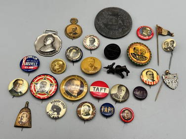
Group of Early Political Buttons; Wilson, Taft, Roosevelt, McKinley, Whisk BroomDana J. Tharp Auctions4.7(268)See Sold PriceFeb 24, 2024
Thirty Pieces of Lackawanna Railroad Ephemera - Chief Engineer Timebook, Map, Public Timetables,Rail & Road Auctions4.6(165)See Sold PriceMar 07, 2024
Group of New York Central Railroad Paper - Rule Books, Employee Timetables, Stationary, Log Books,Rail & Road Auctions4.6(165)See Sold PriceMar 07, 2024
[CIVIL WAR]. Group of Early American CDVs and Tint...Potter & Potter Auctions4.6(539)See Sold PriceMar 07, 2024
GROUP OF EARLY GLASS INC. PR OF CAMPHENE PEG LAMPS FLIP GLASS, MALLET SHAPED DECANTER, ETC. (8)Carlsen Gallery, Inc.4.6(163)See Sold PriceMar 03, 2024
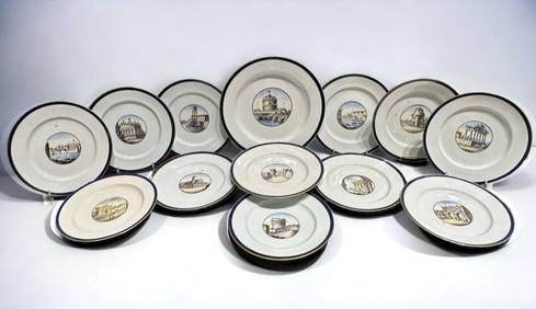
Group of Early Ginori Porcelain Plates with Hand Painted and Named Views, 19thc.Neue Auctions4.6(353)See Sold PriceMar 02, 2024
WEST AFRICA Explorers' routes Senegal Ashanti. Mountains of Kong. SDUK 1857 mapJasper524.5(9.8k)See Sold PriceFeb 28, 2024
AFRICA. Map pre-dating much exploration. Mountains of Kong. SDUK 1851 oldJasper524.5(9.8k)See Sold PriceFeb 28, 2024
WEST AFRICA explorers' routes. Beaufort Gray Park Dochard Caillie. SDUK 1874 mapJasper524.5(9.8k)See Sold PriceFeb 28, 2024
WEST AFRICA I Explorers' routes Senegal Ashanti Ivory Gold Coast. SDUK 1851 mapJasper524.5(9.8k)See Sold PriceFeb 28, 2024
WEST AFRICA showing early explorers' routes & Mountains of Kong. SDUK 1844 mapJasper524.5(9.8k)See Sold PriceFeb 28, 2024
PRE COLONIAL WESTERN AFRICA. Shows Mountains of Kong. Tribes. WELLER 1863 mapJasper524.5(9.8k)See Sold PriceFeb 28, 2024
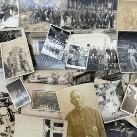
Photography - Set of 30 Photos from Japan - Group photographs - Military photographsProverde Auctions4.3(3)See Sold PriceFeb 28, 2024
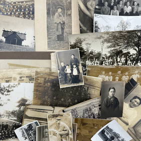
Photography - Set of 30 Photos from Japan - Group photographs - LandscapesProverde Auctions4.3(3)See Sold PriceFeb 28, 2024
Photography - Set of 30 Photos from Japan - Group photographs and portraits of Japanese peopleProverde Auctions4.3(3)See Sold PriceFeb 28, 2024


![[CIVIL WAR]. Group of Early American CDVs and Tint... (1 of 3)](https://p1.liveauctioneers.com/928/318880/171361264_1_x.jpg?height=282&quality=70&version=1707501302)