ATLAS of ANTIENT GEOGRAPHY by SAMUEL BUTLER 1843John McInnis Auctioneers,LLC4.5(494)See Sold PriceFeb 24, 2024
18TH C. ANTIQUE MAP: FRENCH & INDIAN WAR, FRAMEDThomaston Place Auction Galleries4.4(386)See Sold PriceFeb 24, 2024
Rand McNally Railroad Map Cabinet w/ 21 Railroad MapsRail & Road Auctions4.6(165)See Sold PriceMar 08, 2024
Keith Haring - Ink on New York Map, Best Buddies, Inscribed, Signed, and DatedSapphire Auction Gallery3.9(67)See Sold PriceMar 02, 2024
LATE 17TH C. FRENCH MAP OF THE NEW WORLD BY ALEXIS-HUBERT JAILLOT (1632-1712)Thomaston Place Auction Galleries4.4(386)See Sold PriceFeb 24, 2024
Central Railroad of New Jersey Map of Sandy Hook Route-ca. 1903JM Hobby Supply and Railroad Artifact Auctions4.4(126)See Sold PriceFeb 24, 2024
Lot of Six Mixed Atlas Box Cars-HO Scale-New in BoxJM Hobby Supply and Railroad Artifact Auctions4.4(126)See Sold PriceFeb 25, 2024
Rand McNally/Santa Fe Railroad Map of Iowa-1912JM Hobby Supply and Railroad Artifact Auctions4.4(126)See Sold PriceFeb 24, 2024
NICOLAES VISSCHER (NETHERLANDS, 1618-1709) MAP OF THE NEW WORLDThomaston Place Auction Galleries4.4(386)See Sold PriceFeb 24, 2024
17TH C. WORLD MAP BY NICOLAES VISSCHER (NETHERLANDS, 1618-1709)Thomaston Place Auction Galleries4.4(386)See Sold PriceFeb 24, 2024
Lot of Six Mixed Atlas Cabooses-HO Scale-New in BoxJM Hobby Supply and Railroad Artifact Auctions4.4(126)See Sold PriceFeb 25, 2024
SoldGreat Britain.- Moll (Herman) A New Map of GreatGreat Britain.- Moll (Herman) A New Map of Great Britain according to the newest and most exact observations, large detailed map of Britain, with an inset map of the Shetland Islands, picture frame tiSee Sold Price
SoldMOLL, HERMAN. A New Map of Great Britain.MOLL, HERMAN. A New Map of Great Britain. Two-sheet engraved map, 620x1020 mm, ample margins; nicely hand-colored in outline. nice copy. London, circa 1720 All items are offered for sale subject to SwSee Sold Price
SoldMoll (Herman) A New Map of Great BritainMoll (Herman) A New Map of Great Britain, engraved map with outline hand-colouring, 1030 x 630mm., on two sheets, joined, with 4 vertical creases, 2 reinforced verso, several short tears, justSee Sold Price
SoldMoll (Herman) A New Map of Great BritainMoll (Herman) A New Map of Great Britain, According to the Newest and Most Exact Observations, the British Isles, with inset map of the Orkneys and Shetlands, engraved map with hand-colouringSee Sold Price
SoldMoll (Herman) Map of Great BritainMoll (Herman) A New Map of Great Britain, large map of the British Isles with inset map of the Orkneys and Shetlands, on 2 sheets, joined, with original outline hand-colouring, 1020 x 620mm.,See Sold Price
SoldMoll (Herman) A New Map of Great Britain AccordingMoll (Herman) A New Map of Great Britain According to the Newest and Most Exact Sources,engraved map on 2 sheets, Shetland Islands inset, outline colouring, 1011 x 610mm, 1717or later.See Sold Price
Moll (Herman) A New Map of Great Britain AccordingMoll (Herman) A New Map of Great Britain According to the Newest and Most Exact Sources,engraved map on 2 sheets, Shetland Islands inset, outline colouring, 1011 x 610mm, 1717or later.See Sold Price
SoldMOLL - Map of Great BritainMAPS. - MOLL, Herman. A New Map of Great Britain; The South Part of Great Britain, called England and Wales ... 1710.London: printed for H. Moll [second map only: D. Midwinter, T. Bowles and PSee Sold Price
SoldHERMAN MOLL ENGRAVING, NEW MAP OF GREAT BRITAINHERMAN MOLL (DUTCH 1654-1732), HAND COLORED ENGRAVING, " A NEW MAP OF GREAT BRITAIN" 40" X 24" SIGHT:"A New Map of Great Britain, According to the Newest and Most Exact Observations By Herman Moll GeoSee Sold Price
SoldHerman Moll A New Map of Great Britain 1717. TitlHerman Moll A New Map of Great Britain 1717. Title: 'A New Map of Great Britain According to the Newest and Most Exact Observations'. A large and very intricate map of the British isles with colouredSee Sold Price
Herman Moll A New Map of Great BritainAntique map of Great Britain. A New Map of Great Britain According to the newest and most exact observations by Herman Moll, Geographer. Printed and sold by Tho Bowles and John King. Paper 40 1/2"h xSee Sold Price
SoldHERMAN MOLL ANTIQUE MAP OF GREAT BRITAIN CIRCA 1725A FINE HERMAN MOLL MAP OF GREAT BRITAIN CIRCA 1725. A large and impressive map of Great Britain with hand coloring. Being “A New Map of GREAT BRITAIN According to the Newest and Most Exact ObservatiSee Sold Price
SoldMOLL -Map of IrelandMAPS. - MOLL, Herman. A New Map of Ireland ... ; The North Part of Great Britain called Scotland ... 1714.London: printed for H. Moll, D. Midwinter, T. Bowles [first map only: and P. Overton],See Sold Price
SoldMOLL, HERMAN. A New and Exact Map of the DominTHE FAMOUS BEAVER MAP. MOLL, HERMAN. A New and Exact Map of the Dominions of the King of Great Britain on ye Continent of North America. Engraved 2-sheet map joined, 1000x610 mm, margins trimmed to pSee Sold Price
Sold1 piece. Hand-Colored Engraved Map. Moll, Herman.1 piece. Hand-Colored Engraved Map. Moll, Herman. A New and Exact Map of the Dominions of the King of Great Britain on Ye Continent of North America..." (London), 1715 [but 1755]. 24 x 40 inches; 610See Sold Price
SoldMOLL, Herman (d. 1732). A New and Exact Map of thMOLL, Herman (d. 1732). A New and Exact Map of the Dominions of the King of Great Britain on ye continent of North America. [London:] 1715. Engraved map hand-colored in outline, on two sheetsSee Sold Price
SoldMoll NEW AND EXACT MAP OF THE DOMINIONS OF THE KING OFDetails: MOLL, Herman (fl. 1678-1732). A New and Exact Map of the Dominions of the King of Great Britain on ye continent of North America containing Newfoundland, New Scotland, New England, New York,See Sold Price
Moll Map of American ColoniesMOLL, Herman (c.1654-1732). A New and Exact Map of the Dominions of the King of Great Britain on ye Continent of North America...Engraved Map with original hand color in part. Sold By H. Moll over agaSee Sold Price
SoldMoll Beaver Map, 1715MOLL, Herman (1654-1732). [Beaver Map] A New and Exact Map of the Dominions of the King of Great Britain on ye Continent of North America... Engraved Map with original hand color in part. Sold By H. MSee Sold Price
SoldHerman Moll - Map of North American, 1715Herman Moll (c.1654-1732), "A New and Exact Map of the Dominions of the King of Great Britain... Containing Newfoundland, New Scotland, New England, New York, New Jersey, Pensilvania, Maryland, VirginSee Sold Price
Moll Beaver MapMoll, Herman (c.1654-1732). [Beaver Map] A New and Exact Map of the Dominions of the King of Great Britain on ye Continent of North America... Engraved Map with original hand color in part. Sold By H.See Sold Price
Moll, H. Map of Dominions of the King of Great BritainMoll, Hermann A New and Exact Map of the Dominions of the King of Great Britain on the Continent of North America 1715 Copperplate engraving; outline coloured Printed area: 69 x 110 cm; 27.2 x 43 in MSee Sold Price
SoldHERMAN MOLL THE NORTH PART OF GREAT BRITAIN CALHERMAN MOLL THE NORTH PART OF GREAT BRITAIN CALLED SCOTLAND. Engraved map with outline color, London, 1714; Frame: 33' x 49" 25.50" x 40.50" (sight)See Sold Price
Moll (H.) The Southern Part of Great BritainMoll (Herman) The Southern Part of Great Britain called England and Wales,large and detailed map of England and Wales, with many cities, towns, villages, roads and topographical features, distSee Sold Price
Great Western RY November 1, 1880 Public TimetableJM Hobby Supply and Railroad Artifact Auctions4.4(126)See Sold PriceFeb 24, 2024
LARGE LATE 17TH C. DUTCH CHART OF CANADA, GREAT LAKES, NEW FRANCE, LABRADOR, HUDSON BAY, BY PIERREThomaston Place Auction Galleries4.4(386)See Sold PriceFeb 24, 2024
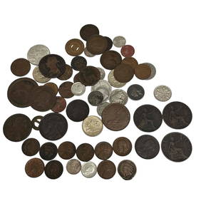
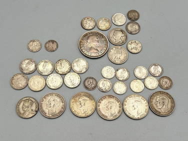
Collection of 61 Foreign and American CoinsPremier Auction Galleries4.3(327)See Sold PriceMar 09, 2024
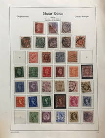
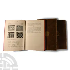
Archaeological Books - Jewitt - The Ceramic Art of Great Britain, Volume I-IIITimeLine Auctions Ltd.4.5(183)See Sold PriceMar 06, 2024
General Books - Four Maps of Great Britain Designed by Matthew Paris About A.D. 1250TimeLine Auctions Ltd.4.5(183)See Sold PriceMar 08, 2024
Group of Canada, New Zealand, Australia, Great Britain Silver CoinsDana J. Tharp Auctions4.6(255)See Sold PriceFeb 24, 2024
(13) 19th C. Prints Great Homes of Britain PrintsEpic Auctions and Estate Sales4.6(198)See Sold PriceMar 02, 2024
1919 The Story of The Great War by Official Sources Volumes 1,2,3,8.North American Artifact Auctions4.7(175)See Sold PriceApr 20, 2024
[MAP]. [ALBRIZZI, Giambatista, 1698-1777]. Carta Geografica...Potter & Potter Auctions4.6(538)See Sold PriceMar 07, 2024
1738 RUSSIA SIBERIA & GREAT TARTARY Description illustrated ANTIQUE in ENGLISHJasper524.5(9.7k)See Sold PriceFeb 27, 2024
Herman Moll A New Map of Ye North Parts of AmericaWillow Auction House4.5(280)See Sold PriceMar 14, 2024
1981 Great Britain Princess Diana 25 New Pence KM#?925 Grades GEM++ UncKey Date Coins4.2(1.2k)See Sold PriceFeb 26, 2024
Vintage Women's Anne Klein Onyx Watch, Gold Tone works great!!! NEWAnnzstiques Auction House4.4(598)$1(1 bid)777 Lots Away


![[MAP]. [ALBRIZZI, Giambatista, 1698-1777]. Carta Geografica... (1 of 1)](https://p1.liveauctioneers.com/928/318880/171361280_1_x.jpg?height=282&quality=70&version=1707501302)


