SoldGerard Mercator, (2) 16th c. maps of British IslesGerard Mercator, (2) 16th c. maps of British Isles, Gerard Mercator (German, 1512-1594), half sheets of Scotland and England, c. 1580s, 19.5"h x 22.5"w (sheet), unframed Provenance: Property from a maSee Sold Price
16th / 18th C. European Maps of New Spain (2)Cartographer: Gerard Mercator. "Hispaniae Novae Nova Descriptio" Published by I.E. Cloppenburgh, Amsterdam, 1632. AND Stieler's "Mexico Und Centro-America …" Gotha, 1828. Two fascinating antique mapSee Sold Price
SoldFramed Map Hannonia NamurcumFramed map Hannonia Namurcum detailed map of regional Germany by Gerard Mercator, Belgium, 16th c., no date 14 3/4" x 19 1/2" site, matted and framed 20 1/2" x 25". CONDITION: Center fold line with teSee Sold Price
Sold(2) 19TH C. BRITISH ISLES MAPSLot of (2) Framed Engraved Maps, incl: North Wales, copper engraving by John Cary (1754-1835), London, publ July 1, 1812, with hand coloring, in a silvered molded wooden frame, with glass, OS: 11 1/4"See Sold Price
SoldEuropean & British Isles Map 18th C.Germany, France, Italy, Spain & British Isles Map . Mons. D'Anville. 1771. Hand-colored. ; 20" x 18 1/2"See Sold Price
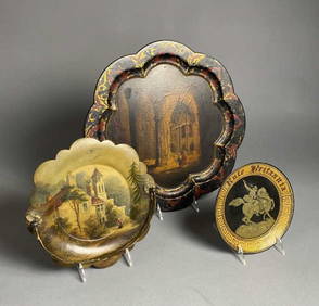
SoldMercator (Gerard) [Tabulae Geographicae]Mercator (Gerard) [Tabulae Geographicae],17 maps only, with 16 showing parts of the British Isles and Ireland, including 'Anglia, Scotia et Hibernia', 'Anglia Regnum', and 'Irlandiae regnum',See Sold Price
SoldTallis & Rapkin Map of The British IslesJ. & F. Tallis (Fl 1850's). The British Isles. Engraved map with hand color in outline from the Illustrated Atlas. London, Edinburgh & Dublin, c. 1851. 10 1/2" x 14 7/8" sheet.See Sold Price
SoldIreland.- Mercator (Gerard) - Irlandiae Regnum,Ireland in 2 full sheets, strapwork title cartouche in lower sheet, ships and sea monster in upper sheet, 2 engraved maps, each c.345 x 470mm., Latin text verso, marginal splitting at foot of each cenSee Sold Price
Mercator (Gerard) - Irlandiae Regnum,Ireland in 2 full sheets, strapwork title cartouche in lower sheet, ships and sea monster in upper sheet, 2 engraved maps, each c.345 x 470mm., Latin text verso, marginal splitting at foot of each cenSee Sold Price
Mercator (Gerard) - Irlandiae Regnum,Ireland in 2 full sheets, strapwork title cartouche in lower sheet, ships and sea monster in upper sheet, 2 engraved maps, each c.345 x 470mm., Latin text verso, marginal splitting at foot of each cenSee Sold Price
-. Mercator (Gerard) - Irlandiae Regnum,Ireland in 2 full sheets, strapwork title cartouche in lower sheet, ships and sea monster in upper sheet, 2 engraved maps, each c.345 x 470mm., Latin text verso, marginal splitting at foot of each cenSee Sold Price
Soldworld.- a small mixed group of mapsWorld.- a small mixed group of maps,including the British Isles, by Sebastian Munster, hand-coloured woodcut map, 80 x 130mm., mounted close, framed and glazed, c.1545 or later; 2 woodblock maSee Sold Price
Sold2 Maps: Mercator + Visscher. Hand colored outline.[Mercator/Visscher] 2 Maps. ++ Gerard Mercator. Das Wiflispurgergow. C. 1610s-1620s. At lower right: “Guilel. Bleau excudit.” 15 x 19 3/4 in. ++ Nicolas Visscher. Totius Alsatiae Novissima Tabula,See Sold Price
SoldSabastian Munster, (German, d.1550), Map of the BrSabastian Munster (German, d.1550) Map of the British Isles a page from a German Atlas, 16th Century 10 1/2 x 7 inches.See Sold Price
SoldSpeed (John) England, Wales, Scotland and IrelandSpeed (John) England, Wales, Scotland and Ireland Described,pictorial title and 63 maps, including 2 folding of the British Isles and Yorkshire, engraved maps, each c.90 x 125mm., but the foldSee Sold Price
SoldBritish Isles.- Mercator (Gerard) & Henricus Hondius.British Isles.- Mercator (Gerard) & Henricus Hondius. Anglia, Scotia et Hibernia, engraving with hand-colouring on laid paper, platemark 340 x 425 mm. (13 1/2 x 16 3/4 in), sheet 445 x 550 mm. (17 1/2See Sold Price
SoldBritish Isles.- Ordnance Survey MapsOrdnance Survey Maps,collection of ordnance survey maps, several linen-backed with illustrated covers, the majority of England and Wales, with c.15 of Scotland, and 2 of Ireland, comprising mSee Sold Price
SoldBritish Isles.- Channel Islands.- Mercator (Gerard)British Isles.- Channel Islands.- Mercator (Gerard) Anglesey, Ins. [on sheet with] Wight ol. Vectis [and] Ins. Garnesey [and] Ins. Iarsey, four maps on one sheet depicting the English islands of JerseSee Sold Price
SoldMercator and Hondius. Eastern England 2 mapsMercator (Gerard) and Jodocus Hondius. Eboracum Lincolnia Derbia, Stafford, etc; Warwicum Northampton, Huntingdon Cantabr. etc,2 maps of the eastern half of England, from Hartlepool to the IsSee Sold Price
SoldLate 16th / Early 17thc Map of South East England,Gerard Mercator ( 1565 - 1656 ) engraved map of "South East England". With Latin text to the reverse, in modern Hogarth frame with glass to both sides.14 1/2" X 18 1/2". Provenance : R. Deverall, DuvaSee Sold Price
Late 16th / Early 17thc Map of South East England,Gerard Mercator ( 1565 - 1656 ) engraved map of "South East England". With Latin text to the reverse, in modern Hogarth frame with glass to both sides.14 1/2" X 18 1/2". Provenance : R. Deverall, DuvaSee Sold Price
Late 16th / Early 17thc Map of South East EnglandGerard Mercator ( 1565 - 1656 ) engraved map of "South East England". With Latin text to the reverse, in modern Hogarth frame with glass to both sides.14 1/2" X 18 1/2". Provenance : R. Deverall, DuvaSee Sold Price
Late 16th / Early 17thc Map of South East EnglandGerard Mercator ( 1565 - 1656 ) engraved map of "South East England". With Latin text to the reverse, in modern Hogarth frame with glass to both sides.14 1/2" X 18 1/2". Provenance : R. Deverall, DuvaSee Sold Price
Late 16th / Early 17thc Map of South East EnglandGerard Mercator ( 1565 - 1656 ) engraved map of "South East England". With Latin text to the reverse, in modern Hogarth frame with glass to both sides.14 1/2" X 18 1/2". Provenance : R. Deverall, DuvaSee Sold Price
Grand Trunk Railroad Across the Continent Through Canada Book-1917JM Hobby Supply and Railroad Artifact Auctions4.4(127)See Sold PriceFeb 24, 2024
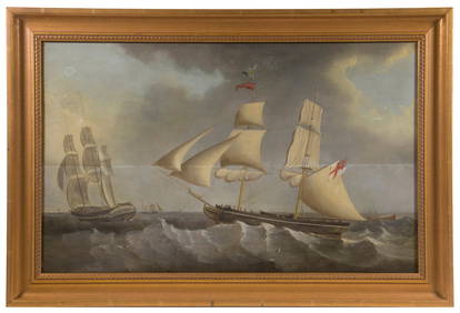
LATE 18TH C. OIL PAINTING OF BRITISH MAN-O-WARThomaston Place Auction Galleries4.4(393)See Sold PriceFeb 24, 2024
LATE 17TH C. FRENCH MAP OF THE NEW WORLD BY ALEXIS-HUBERT JAILLOT (1632-1712)Thomaston Place Auction Galleries4.4(393)See Sold PriceFeb 24, 2024
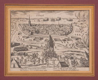
17TH C. ANTIQUE MAP SIEGE OF LA ROCHELLE, FRANCE, FRAMEDThomaston Place Auction Galleries4.4(393)See Sold PriceFeb 24, 2024
EARLY 18TH C. MAP OF ITALY, FRAMEDThomaston Place Auction Galleries4.4(393)See Sold PriceFeb 24, 2024
LATE 16TH C. MAP OF SCOTLAND BY MERCATOR, FRAMEDThomaston Place Auction Galleries4.4(393)See Sold PriceFeb 24, 2024
17TH C. MAP OF THE BERKSHIRES BY JOHN SPEED, FRAMEDThomaston Place Auction Galleries4.4(393)See Sold PriceFeb 24, 2024
18TH C. ANTIQUE MAP: FRENCH & INDIAN WAR, FRAMEDThomaston Place Auction Galleries4.4(393)See Sold PriceFeb 24, 2024
16TH C. BIRDSEYE VIEW OF SEIGE OF STEENWYCK, NETHERLANDS BY FRANS HOGENBERG (1535-1590)Thomaston Place Auction Galleries4.4(393)See Sold PriceFeb 24, 2024
17TH C. ENGLISH LINEAR MAP BY OGILBY, FRAMEDThomaston Place Auction Galleries4.4(393)See Sold PriceFeb 24, 2024
19th C British Hand Painted Paper Mache TraysEpic Auctions and Estate Sales4.6(210)See Sold PriceMar 02, 2024
AN ANTIQUE FOLDING MAP OF THE BRITISH ISLES DATED 1873Hutchinson Scott Auctioneers4.4(42)See Sold PriceFeb 28, 2024
Willem Blaeu, Etc. 17th C. Antiquarian Maps, 2Auctions at Showplace4.6(740)See Sold PriceMar 17, 2024
Two (2) Antique 18th C. Copper Engraved Framed Maps - America & EuropeMagnusson Art Group4.5(53)See Sold PriceMar 14, 2024
De Jode, Rare, pub. 1593 - Map of the British Isles [England, Scotland, Ireland] (Angliae Scotiae etTrillium Antique Prints & Rare Books4.5(32)See Sold PriceFeb 24, 2024
De Jode, Rare, pub. 1593 - Map of Africa (Africae Vera Forma, et Situs)Trillium Antique Prints & Rare Books4.5(32)See Sold PriceFeb 24, 2024
1683 Sanson Map of the Caribbean -- Les Isles Antilles, &c Entre Lesquelles sont les Lucayes, et lesJasper524.5(9.9k)See Sold PriceFeb 27, 2024


![Mercator (Gerard) [Tabulae Geographicae] (1 of 1)](https://p1.liveauctioneers.com/410/27980/10669036_1_x.jpg?height=282&quality=70&version=1326123390)


![De Jode, Rare, pub. 1593 - Map of the British Isles [England, Scotland, Ireland] (Angliae Scotiae et (1 of 2)](https://p1.liveauctioneers.com/6581/319571/171593327_1_x.jpg?height=282&quality=70&version=1707853304)


