SoldGEOGRAPHICAL & STATISTICAL MAPS OF DENMARK, SWEDEN & NODenmark, Sweden and Norway after the fall of Napolean 1820 by M. Carey & Son, hand-colored map surrounded by statistical data. Sight size 17 x 21 inches, overall 26.75 x 29.See Sold Price
Geographical Statistical Map of Denmark & Sweden, 1822Map: Geographical and Statistical Map of Denmark and Sweden. Publication Date: 1822 Author: M. CAREY, GROS, C./J. YEAGER Publisher: M. CAREY Size: Quarto – 10.75 H x 14.50 W Inches Restriking of GroSee Sold Price
Geographical Statistical Map of Denmark & Sweden, 1822Map: Geographical and Statistical Map of Denmark and Sweden. Maker: M. Carey, Gros, C./j. Yeager Publication Date: 1822 Publisher: M. Carey Size: Quarto – 10.75 H x 14.50 W Inches Restriking of GrosSee Sold Price
Geographical and Statistical Map of Norway and SwedenTitle/Content of Map: Map of Denmark &C. | Geographical and Statistical Map of Norway and Sweden Date Printed: 1820 Cartographer: GROS, C. Size (inches): 11.6x11.3 "including the placed rendered celebSee Sold Price
Carey: Geographical and Statistical Map of Denmark andMap: Geographical and Statistical Map of Denmark and Sweden Maker: M. Carey, Gros, C./J. Yeager Publishing Date: 1822 Size: Quarto - 10.75 x 14.50 inches, Restriking of Gros's map of Denmark &c. And mSee Sold Price
T.G. Bradford: Map of Denmark Sweden Norway LaplandMap: Denmark, Sweden, Norway & Lapland Maker: T. G. Bradford Date: 1835 Size: 7.75 x 10 (9.5 x 12.875) inches From Bradford’s first atlas, the Comprehensive Atlas Geographical, Historical & CommerciSee Sold Price
SoldGuthrie, William 1799 Map Sweden Norway Finland DenmarkOutline Hand Colored Copper Engraved Map Published 1799, London for "A New Geographical, Historical and Commercial Grammar..." by William Guthrie. The maps are by D. Ogilby & Son and others. Folds asSee Sold Price
A new and correct map of Norway, Sweden and Denmark. Finland. MOORE 1788TITLE/CONTENT OF MAP: 'A new and correct map of Norway, Sweden and Denmark from the latest Geographical Improvements' DATE PRINTED: 1788 IMAGE SIZE: Approx 21.5 x 28.0cm, 8.5 x 11 inches (Medium) TYPESee Sold Price
A new and correct map of Norway, Sweden and Denmark. Finland. MOORE 1788TITLE/CONTENT OF MAP: 'A new and correct map of Norway, Sweden and Denmark from the latest Geographical Improvements' DATE PRINTED: 1788 IMAGE SIZE: Approx 21.5 x 28.0cm, 8.5 x 11 inches (Medium) TYPESee Sold Price
Sold1831 Woodbridge Map of the United States -- Geographical & Statistical Map of the United States.Title: 1831 Woodbridge Map of the United States -- Geographical & Statistical Map of the United States. Adapted to Woodbridge's Geography Cartographer: W. Woodbridge Year / Place: 1831, Hartford Map DSee Sold Price
SoldCarey: Geographical & Statistical Map of Europe, 1822Geographical and Statistical Map of Europe. M. Carey, Young & Delleker 1822. Restriking of map, Europe: drawn from the best authorities for the illustration of Lavoisne's genealogical, historical, chrSee Sold Price
Lavoisne: Geographical & Statistical Map of France 1820Map: Geographical and Statistical Map of France Cartographer: M. Lavoisne Date: 1820 Origin: Philadelphia Size: 16.5 x 20.5 inches Colorful map of France. This Copper Plate map shows geographical featSee Sold Price
Lavoisne: Geographical & Statistical Map of Europe 1821Map: 1821 Lavoisne Map of Europe -- Geographical and Statistical Map of Europe Cartographer: M. Lavoisne Year / Place: 1821, Philadelphia Dimensions: 20.5 x 16.5 in. Condition: Very good, slight age tSee Sold Price
Buchon: Geographical Statistical Map of Peru, 1825Map: 1825 Carte Geographique, Statistique et Historique Du Perou. By: Jean Alexandre Buchon Date: 1825 (Published) Paris Dimensions: 18.5 x 24.5 inches (47 cm x 62 cm) Condition: This map is in A condSee Sold Price
1831 Woodbridge Map of Europe -- Geographical & Statistical Map of EuropeTitle: 1831 Woodbridge Map of Europe -- Geographical & Statistical Map of Europe Cartographer: W. Woodbridge Year / Place: 1831, Hartford Map Dimension (in.): 8.2 X 10.8 in. This is a very nice map ofSee Sold Price
Buchon: Geographical Statistical Map of Martinique 1825Map: 1825 Carte Geographique, Statistique, et Historique de la Martinique By: Jean Alexandre Buchon Date: 1825 (Published) Paris Dimensions: 18 x 24 inches (45.72 x 60.96 cm) Condition: Map is in A+ cSee Sold Price
Geographical & Statistical Map of Spain & Portugal 1822Map: Geographical and Statistical Map of Spain and Portugal Maker: M. Carey, Gros, C./E. Paquenaud/J. Yeager Date: 1822 Size: Octavo, 10.6 inches high x 13 inches wide Restriking of a map by Gros, impSee Sold Price
1831 Woodbridge Map of South America and Africa -- Comparative, Geographical & Statistical Map ofTitle: 1831 Woodbridge Map of South America and Africa -- Comparative, Geographical & Statistical Map of South America & Africa Cartographer: W. Woodbridge Year / Place: 1831, Hartford Map Dimension (See Sold Price
1831 Woodbridge Map of Europe -- Geographical & Statistical Map of EuropeTitle: 1831 Woodbridge Map of Europe -- Geographical & Statistical Map of Europe Cartographer: W. Woodbridge Year / Place: 1831, Hartford Map Dimension (in.): 8.2 X 10.8 in. This is a very nice map ofSee Sold Price
Sold1815 POLAND HUNGARY GEOGRAPHICAL & STATISTICAL MAP1815 POLAND HUNGARY GEOGRAPHICAL & STATISTICAL MAP Size: 27.5 x 23.5" including frame Condition: Very good, crease to center.See Sold Price
SoldGEOGRAPHICAL & STATISTICAL MAP OF RUSSIA 1820The Russian Empire after the fall of Napolean 1820 by M. Carey & Son, hand-colored map surrounded by statistical data. Sight size 16.5 x 21 inches, overall 26.75 x 29.See Sold Price
SoldGeographical & Statistical Map of England for theGeographical and Statistical Map of England for the Elucidation of Lavoisne's Genealogical Historical Chronological and Geographical Atlas, 1828, printed by J. Barfield, hand-colored copper engraved mSee Sold Price
SoldGEOGRAPHICAL & STATISTICAL MAP OF CANADA, 1823Hand-colored map surrounded by statistical data, 'Geographical, Statistical and Historical Map of Upper and Lower Canada, and the Other British Possessions in North America.' Sight size 17 x 21, overaSee Sold Price
Finley: Map of Denmark, Sweden and Norway, 1829Title/Content of Map: Denmark, Sweden and Norway Date Printed: 1829 Cartographer: FINLEY, ANTHONY/YOUNG & DELLEKER Size (inches): 8.5x8.5 Topographia and political map. Please note that this lot has aSee Sold Price
Nova Totius Full Color Geographical World MapThe Benefit Shop Foundation Inc.4.3(2.9k)See Sold PriceFeb 28, 2024
Vintage County Map Of NY State Plate EngravingThe Benefit Shop Foundation Inc.4.3(2.9k)See Sold PriceFeb 28, 2024
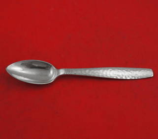
Swedish Modern by Allan Adler Sterling Silver Grapefruit Spoon Original 6"Bidhaus4.3(762)See Sold PriceFeb 25, 2024
Vintage Framed Pine Island & Lacoste Island MapThe Benefit Shop Foundation Inc.4.3(2.9k)See Sold PriceMar 06, 2024
1822 MAP of LEEWARD ISLANDS GEOGRAPHICAL STATISTICAL HISTORICAL antique 17.5x22"Jasper524.5(9.9k)See Sold PriceFeb 27, 2024
1822 MAP of SOUTH AMERICA GEOGRAPHICAL STATISTICAL HISTORICAL antique 17.5x 22"Jasper524.5(9.9k)See Sold PriceFeb 27, 2024
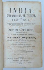
1858 INDIA HISTORY ILLUSTRATED antique Geographical, Statistical, and HistoricalJasper524.5(9.9k)See Sold PriceFeb 27, 2024
1822 MAP of NORTH & SOUTH AMERICA GEOGRAPHICAL STATISTICAL HISTORICAL antiqueJasper524.5(9.9k)See Sold PriceFeb 27, 2024
1822 MAP of CHILI GEOGRAPHICAL STATISTICAL HISTORICAL antique 17.5x 22" CHILEJasper524.5(9.9k)See Sold PriceFeb 27, 2024
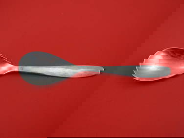
Swedish Modern by Allan Adler Sterling Silver Preserve Spoon 7"Mynt Auctions4.6(697)See Sold PriceMar 01, 2024
Sigvard Bernadotte, Bernadotte flatware serviceToomey & Co. Auctioneers4.7(392)See Sold PriceFeb 29, 2024
Geographical, Statistical, and Historical Map of the Leeward Islands.Jasper524.5(9.9k)See Sold PriceFeb 27, 2024
Geographical Statistical and Historical Map of the Windward IslandsJasper524.5(9.9k)See Sold PriceFeb 27, 2024
Geographical, Statistical, and Historical Map of the West Indies.Jasper524.5(9.9k)See Sold PriceFeb 27, 2024
Cooke, George 1801 Antique Map. Sweden, Denmark, Norway, IcelandAlbion Auctions4.6(341)See Sold PriceMar 01, 2024
Carl J. Sundevall (1801 - 1875) Set of 4 Bird Prints - Dove - Woodpecker - DuckProverde Auctions4.3(3)See Sold PriceFeb 28, 2024
Joachim Ferdinand Richardt - Set of 8 Prints - Topographical views of Castels in Sweden - SkabersjöProverde Auctions4.3(3)See Sold PriceFeb 28, 2024
Joachim Ferdinand Richardt - Set of 8 Prints - Topographical views of Castels in Sweden - RosendahlProverde Auctions4.3(3)See Sold PriceFeb 28, 2024
Set of 4 Maps - Netherlands - Seven United Provinces - Germany - Sweden, Denmark, Norway, FinlandProverde Auctions4.3(3)See Sold PriceFeb 28, 2024