ATLAS of ANTIENT GEOGRAPHY by SAMUEL BUTLER 1843John McInnis Auctioneers,LLC4.5(505)See Sold PriceFeb 24, 2024
18TH C. ANTIQUE MAP: FRENCH & INDIAN WAR, FRAMEDThomaston Place Auction Galleries4.4(393)See Sold PriceFeb 24, 2024
Rand McNally Railroad Map Cabinet w/ 21 Railroad MapsRail & Road Auctions4.6(165)See Sold PriceMar 08, 2024
Keith Haring - Ink on New York Map, Best Buddies, Inscribed, Signed, and DatedSapphire Auction Gallery4.1(67)See Sold PriceMar 02, 2024
LATE 17TH C. FRENCH MAP OF THE NEW WORLD BY ALEXIS-HUBERT JAILLOT (1632-1712)Thomaston Place Auction Galleries4.4(393)See Sold PriceFeb 24, 2024
Central Railroad of New Jersey Map of Sandy Hook Route-ca. 1903JM Hobby Supply and Railroad Artifact Auctions4.4(127)See Sold PriceFeb 24, 2024
Lot of Six Mixed Atlas Box Cars-HO Scale-New in BoxJM Hobby Supply and Railroad Artifact Auctions4.4(127)See Sold PriceFeb 25, 2024
Rand McNally/Santa Fe Railroad Map of Iowa-1912JM Hobby Supply and Railroad Artifact Auctions4.4(127)See Sold PriceFeb 24, 2024
NICOLAES VISSCHER (NETHERLANDS, 1618-1709) MAP OF THE NEW WORLDThomaston Place Auction Galleries4.4(393)See Sold PriceFeb 24, 2024
17TH C. WORLD MAP BY NICOLAES VISSCHER (NETHERLANDS, 1618-1709)Thomaston Place Auction Galleries4.4(393)See Sold PriceFeb 24, 2024
Lot of Six Mixed Atlas Cabooses-HO Scale-New in BoxJM Hobby Supply and Railroad Artifact Auctions4.4(127)See Sold PriceFeb 25, 2024
Geographical and Statistical Map of England, 1821Map: Map of England with Wales - Geographical and Statistical Map of England Cartographer: M. Lavoisne Year / Place: 1821 Philadelphia Map Dimensions: 16.5 x 20.5 in. Colorful map of England, includinSee Sold Price
1821 Lavoisne Map of England with Wales - GeographicalTitle: 1821 Lavoisne Map of England with Wales - Geographical and Statistical Map of England Date: 1821 Philadelphia Cartographer: M. Lavoisne Size: 16.5 x 20.5 in. Additional Information: Colorful maSee Sold Price
1821 Lavoisne Map of England with Wales1821 Lavoisne Map of England with Wales - Geographical and Statistical Map of England. M. Lavoisne. 1821 Philadelphia. 16.5 x 20.5 in. Colorful map of England, including Wales. This Copper Plate map sSee Sold Price
Sold1821 Carey & Lea Map of England1821 Carey & Lea map of England. Full original hand coloring. Geographical and Statistical Map of England (Cartouche: England & Wales divided into Circuits & Counties with the Principal High Roads). FSee Sold Price
Lavoisne: Antique Map of England with Wales, 1821Title/Content of Map: 1821 Lavoisne Map of England with Wales - Geographical and Statistical Map of England Date Printed: 1821 Philadelphia Cartographer: M. Lavoisne Size: 16.5 x 20.5 in. Colorful mapSee Sold Price
Lavoisne: Antique Map of England with Wales, 1821Title/Content of Map: 1821 Lavoisne Map of England with Wales - Geographical and Statistical Map of England Date Printed: 1821 Philadelphia Cartographer: M. Lavoisne Size: 16.5 x 20.5 in. Colorful mapSee Sold Price
Lavoisne: Antique Map of England with Wales, 1821Map: 1821 Lavoisne Map of England with Wales - Geographical and Statistical Map of England Cartographer: M. Lavoisne Year / Place: 1821 Philadelphia Map Dimensions: 16.5 x 20.5 in. Condition: Very GooSee Sold Price
Lavoisne: Antique Map of England with Wales, 1821Title: 1821 Lavoisne Map of England with Wales - Geographical and Statistical Map of England Cartographer: M. Lavoisne Year / Place: 1821 Philadelphia Map Dimensions: 16.5 x 20.5 in. Condition: Very GSee Sold Price
1821 Lavoisne Map of England with Wales - GeographicalTitle/Content of Map: 1821 Lavoisne Map of England with Wales - Geographical and Statistical Map of England Date Printed: 1821 Philadelphia Cartographer: M. Lavoisne Size: 16.5 x 20.5 in. Colorful mapSee Sold Price
1821 Lavoisne Map of England with Wales - GeographicalReserve Reduced! Title/Content of Map: 1821 Lavoisne Map of England with Wales - Geographical and Statistical Map of England Date: 1821 Philadelphia Cartographer: M. Lavoisne Size: 16.5 x 20.5 in. ColSee Sold Price
SoldGeographical & Statistical Map of England for theGeographical and Statistical Map of England for the Elucidation of Lavoisne's Genealogical Historical Chronological and Geographical Atlas, 1828, printed by J. Barfield, hand-colored copper engraved mSee Sold Price
Lavoisne: Geographical & Statistical Map of Europe 1821Map: 1821 Lavoisne Map of Europe -- Geographical and Statistical Map of Europe Cartographer: M. Lavoisne Year / Place: 1821, Philadelphia Dimensions: 20.5 x 16.5 in. Condition: Very good, slight age tSee Sold Price
Sold1820 MAP OF ENGLAND AND WALES BY ASPIN AND CAREYProfessionally matted geographical and statistical map of England and Wales, 15.75 x 13 inch sight size.See Sold Price
1821 GEOGRAPHICAL AND STATISTICAL MAP OF EUROPE...GEOGRAPHICAL AND STATISTICAL MAP OF EUROPE. Europe: Drawn from the best Authorities for the Illustration of Lavoisne's Genealogical, Historical, Chronological & Geographical Atlas. Improved to 1821. BSee Sold Price
SoldLavoisne: Antique Map of Europe, 1821Map: 1821 Lavoisne Map of Europe -- Geographical and Statistical Map of Europe Cartographer: M. Lavoisne Year / Place: 1821, Philadelphia Dimensions: 20.5 x 16.5 in. Condition: Very good, slight age tSee Sold Price
Sold1821 Carey & Lea Map of North and South America1821 Carey & Lea map of North and South America. 1821 Geographical, Historical, and Statistical Map of America. from the third Philadelphia Edition. Printed by T. H. Palmer for M. Carey & Son, from thSee Sold Price
SoldEngraved Map of AmericaYoung & Delleker, 1821, "Geographical, Historical, and Statistical Map of America" with engraved maps, original coloring, 17" x 21 1/2" sight size, 24" x 29 3/4" framed.See Sold Price
SoldLavoisne: North and South America, 1821Map: Geographical, Historical, and Statistical Map of America. North America / South America Maker: Lavoisne Publisher: "Aspin, J. / E. Paguenaud. Philadelphia. M. Carey & Son. 1821 Size: North AmericSee Sold Price
Sold4 Maps: Bradford, (1838). Maine, NH, Vermont, RI.[United States/New England] 4 Maps. ++ MAINE. ++ NEW HAMPSHIRE. ++ VERMONT. ++ RHODE ISLAND. ++ Maps 7, 8, 9, and 12 from T. G. Bradford, “An Illustrated Atlas, Geographical, Statistical, And HistorSee Sold Price
Map of England Scotland & Ireland, 1821Map of England Scotland & Ireland, Indicating the Places Rendered Celebrated by Battles or Sieges. Geographical and Historical Map of the British Empire. Carey and Sons 1821, 21.75 x 17.25 inches PleaSee Sold Price
Sold1831 Woodbridge Map of the United States -- Geographical & Statistical Map of the United States.Title: 1831 Woodbridge Map of the United States -- Geographical & Statistical Map of the United States. Adapted to Woodbridge's Geography Cartographer: W. Woodbridge Year / Place: 1831, Hartford Map DSee Sold Price
SoldCarey: Geographical & Statistical Map of Europe, 1822Geographical and Statistical Map of Europe. M. Carey, Young & Delleker 1822. Restriking of map, Europe: drawn from the best authorities for the illustration of Lavoisne's genealogical, historical, chrSee Sold Price
SoldGEOGRAPHICAL & STATISTICAL MAPS OF DENMARK, SWEDEN & NODenmark, Sweden and Norway after the fall of Napolean 1820 by M. Carey & Son, hand-colored map surrounded by statistical data. Sight size 17 x 21 inches, overall 26.75 x 29.See Sold Price
Sold1815 POLAND HUNGARY GEOGRAPHICAL & STATISTICAL MAP1815 POLAND HUNGARY GEOGRAPHICAL & STATISTICAL MAP Size: 27.5 x 23.5" including frame Condition: Very good, crease to center.See Sold Price
1822 MAP of LEEWARD ISLANDS GEOGRAPHICAL STATISTICAL HISTORICAL antique 17.5x22"Jasper524.5(9.9k)See Sold PriceFeb 27, 2024
1822 MAP of SOUTH AMERICA GEOGRAPHICAL STATISTICAL HISTORICAL antique 17.5x 22"Jasper524.5(9.9k)See Sold PriceFeb 27, 2024
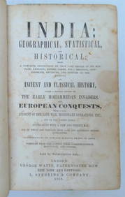
1858 INDIA HISTORY ILLUSTRATED antique Geographical, Statistical, and HistoricalJasper524.5(9.9k)See Sold PriceFeb 27, 2024
1822 MAP of NORTH & SOUTH AMERICA GEOGRAPHICAL STATISTICAL HISTORICAL antiqueJasper524.5(9.9k)See Sold PriceFeb 27, 2024
1822 MAP of CHILI GEOGRAPHICAL STATISTICAL HISTORICAL antique 17.5x 22" CHILEJasper524.5(9.9k)See Sold PriceFeb 27, 2024
Geographical, Statistical, and Historical Map of the Leeward Islands.Jasper524.5(9.9k)See Sold PriceFeb 27, 2024
Geographical Statistical and Historical Map of the Windward IslandsJasper524.5(9.9k)See Sold PriceFeb 27, 2024
Geographical, Statistical, and Historical Map of the West Indies.Jasper524.5(9.9k)See Sold PriceFeb 27, 2024