SoldFuller (Thomas) - A group of 8 maps of the Holy Land,for A Pisgah-Sight of Palestine, engraved maps by Goddard, Marshall, Vaughan and others, all with hand-colouring, each average 290 x 340mm., all with a central vertical fold, occasional slight browninSee Sold Price
Sold(HOLY LAND.) Fuller, Thomas. Group of 4 hand-colored(HOLY LAND.) Fuller, Thomas. Group of 4 hand-colored double-page engraved maps, from A Pisgah-Sight of Palestine. Approximately 13x15 inches each sheet size, wide margins; only minor flaws. - London,See Sold Price
Fuller (Thomas) The Holy LandFuller (Thomas) The Holy Land,two maps from A Pisgah-Sight of Palestine, each with ornamental title and scale cartouches, each with pairs of compasses, engraved maps, each 280 x 335mm., each wSee Sold Price
Sold(HOLY LAND.) Fuller, Thomas. Confinia Palestin(HOLY LAND.) Fuller, Thomas. Confinia Palestinae. Double-page engraved map, 295x345 mm, wide margins; topographical and pictorial elements hand-colored. London, 1650 All items are offered for sale suSee Sold Price
Map of the North of the Holy Land. Thomas Fuller.Naphtali. Map of the north of the Holy Land, the land of Naphtali and its neighbors: Asher, Dan, Levi, Zebulen. The Jerusalem-Damascus route is marked. By: Thomas Fuller. From: A Pisgah sight of PalesSee Sold Price
FULLER THOMASA Pisgah sight of Palestine and it’s confines with history of old and new testament. London, 1650. With engraved titles and many double page maps and plans. An important work on the Holy Land..See Sold Price
Sold(HOLY LAND.) Group of 8 seventeenth-and-eighteenth(HOLY LAND.) Group of 8 seventeenth-and-eighteenth century double-page engraved maps. Vp, vd Pierre du Val. Terra Sancta Quae et Terra Chanaan, Terra Promissionis, Terra Hebreorum, Terra Israelitarum,See Sold Price
SoldGroup of six maps of the Holy Lands, four are 14.Group of six maps of the Holy Lands, four are 14.25”x18.5” and two are hand-colored 8”x10”See Sold Price
SoldHoly Land.- Conder (Thomas) A Map of The Land ofHoly Land.- Conder (Thomas) A Map of The Land of Canaan, engraving with hand-colouring, 350 x 360 mm (13 3/4 x 14 1/8 in), old folds as issued, handling creases, spotting and surface dirt, unframed, CSee Sold Price
SoldHoly Land.- Conder (Thomas) A Map of The Land ofHoly Land.- Conder (Thomas) A Map of The Land of Canaan, engraving with hand-colouring, 350 x 360 mm (13 3/4 x 14 1/8 in), old folds as issued, handling creases, spotting and surface dirt, unframed, CSee Sold Price
SoldThomas Bowen map, Holy LandMap, Thomas Bowen (1749-1790), An Accurate Map of the Holy Land, with the Adjacent Countries, circa 1770, London, copper plate engraving, with partial color, sight: 12''h x 7.5''w, frame: 16.25''h x 1See Sold Price
Sold(8) 18TH CENTURY MAPS OF THE HOLY LAND(6) black and white, "De l'Asie" with maps of Syria and Jerusalem, 8 1/4" x 5 1/4" and (2) hand colored,"Terra Sancta" and "Judee on Terre Sainte" 7" x 9" and 11" x 15 1/2"; also (1) hand colored mapSee Sold Price
Solda group of 4 maps of the Holy Landa group of 4 maps of the Holy Land,including Iudæa seu Terra Sancta, by Sanson, engraved map with hand-colouring, 570 x 850mm., some offsetting, Paris, Jaillot, 1691; Iudæa seu Palæstina, bySee Sold Price
group of English maps of the Holy Landa mixed group of English maps of the Holy Land,including Canaan comonly called the Holy Land, by Richard Palmer for Richard Blome, 1687; A New Map shewing the Travels of the Patriarchs, by SuSee Sold Price
Solda group of 5 maps of the Holy Landa group of 5 maps of the Holy Land,including Carte de la Situation du Paradis Terrestre, by Huet; Het Beloofde Landt Canaan, by Wetstein, Smith and Luchtmans; Peregrinatie ofte Veertich-IarigSee Sold Price
SoldHoly Land.- - a group of 13 maps of the Holy Land ininclduing Canaan comonly called the Holy Land, by Blome, Syrie sive Soriae, by Cluverius and Regnum Salomonicum, by de la Rue, engraved maps of which 12 coloured, v.s., from 120 x 120mm to 440 x 540mmSee Sold Price
Solda group of 4 maps of the Holy Landa group of 4 maps of the Holy Land,including Tabula Itineraria Patriarcharum Abrahami, Isaaci et Iacobi, by Jansson; Georgraphiæ Sacræ by Sanson; Voyage des Enfans d'Israel, and Carte de la TSee Sold Price
Sold[Maps & Atlases] (Adrichom, Christian van), Group of 5[Maps & Atlases] (Adrichom, Christian van) Group of 5 Maps of the Holy Land No place, no date (ca. 1590). Five maps of the territories of the Tribes of Israel, including: Tribus Aser, Tribus Gad, TribSee Sold Price
Sold(MAP) ORTELIUS, ABRAHAM Size of frame 20 x 26 1/4 i(MAP) ORTELIUS, ABRAHAM A group of two maps of the Holy Land and surrounding Mediterranean. (Antwerp, c. 1580). Hand-colored. Framed and matted. Palestinae sive totius terrae promissionis nova descripSee Sold Price
SoldJewish History.- mixed group of prints & mapsJewish History.- a mixed group of prints and maps,most of the Holy Land or Old Testament scenes, some of the European diaspora, and a few portraits, engravings, a woodcut map by Munster, wood-See Sold Price
SoldCollection of Antiquated Maps of the Holy Land [8],Collection of eight geographic maps of the Holy Land. Various maps. Printed in various countries. Some maps with tribal divisions. Fine - very fine condition.See Sold Price
SoldVelde, C. W. M. van de Map of the Holy Land. 8Velde, C. W. M. van de Map of the Holy Land. 8 Kartensegmente. Gotha, J. Perthes, 1858. Lose in OLwd.-Mappe. (etwas fleckig u. berieben).Palästina Velde, C. W. M. van de Map of the Holy Land. 8 KSee Sold Price
SoldHoly Land.- a small group of mapsHoly Land.- a small group of maps,including 'Situs Terrae Promissionis Sev Terrae Sanctae', a map after Adrichom, with north orientated to the lower edge, engraving, 200 x 500mm, rebacked withSee Sold Price
SoldVelde, C. W. M. van de Map of the Holy Land. 8Map of the Holy Land. 8 Kartensegmente. Gotha, J. Perthes, 1858. Lose in OLwd.-Mappe. (etwas fleckig u. berieben). Einzige Separatausgabe, selten. Die Segmente jeweils 42 x 34 cm. Das letzte Segment bSee Sold Price
DAVID ROBERTS - Holy Land / Syria / Egypt etc. 3 x Folio Volumes 1849 Very RareLuis Porretta Fine Arts4.3(10)See Sold PriceMar 02, 2024
7 Greeting Postcards for British Soldiers - Holy LandLevy Auction House4.3(11)See Sold PriceFeb 27, 2024
Excursions to Palestine - Thomas Cook - 19th CenturyLevy Auction House4.3(11)See Sold PriceFeb 27, 2024
1849 Mitchell School ATLAS 24 MAPS America Holy Land France Africa Egypt AsiaSchilb Antiquarian Rare Books4.8(431)See Sold PriceMar 31, 2024
1872 Holy BIBLE & Hitchcock Analysis Gruden Concordance Theology MAPS Holy LandSchilb Antiquarian Rare Books4.8(431)See Sold PriceMar 31, 2024
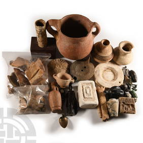
Ancient Holy Land Terracotta 2-Handled Vessel 8 1/2 inches heightGCB Estate Sales4.5(86)See Sold PriceMar 02, 2024
Group of 2 Ancient Holy Land Terracotta Bowl and VesselGCB Estate Sales4.5(86)See Sold PriceMar 02, 2024
AN EARLY HOLY LAND SILVER MEGILLAH CASE WITH ORIGINAL MEGILLAH. Palestine, c.1920. Decorated withJ. Greenstein & Co., Inc.4.2(55)See Sold PriceApr 16, 2024
TWO ANTIQUE JEWISH NATIONAL FUND CHARITY BOXES. The first one made in Berlin c. 1920J. Greenstein & Co., Inc.4.2(55)See Sold PriceApr 16, 2024
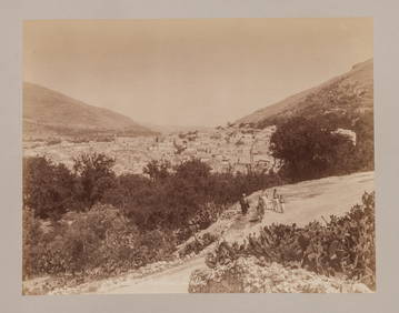
A GROUP OF THREE EARLY HOLY LAND BLACK AND WHITE PHOTOS BY C.N.G. ZANGAKI. C.1870. 11” xJ. Greenstein & Co., Inc.4.2(55)See Sold PriceApr 16, 2024
A GROUP OF TWO EARLY BLACK AND WHITE HOLY LAND PHOTOGRAPHS BY AMERICAN COLONY PHOTOGRAPHERS.J. Greenstein & Co., Inc.4.2(55)See Sold PriceApr 16, 2024
A GROUP OF SEVEN EARLY HOLY LAND BLACK AND WHITE PHOTOS BY FELIX BONFILS. 11” x 8.5”.J. Greenstein & Co., Inc.4.2(55)See Sold PriceApr 16, 2024
ANCIENT MIDDLE EASTERN HOLY LAND TERRACOTTA PLATEAntique Arena Inc.4.5(883)See Sold PriceJun 15, 2024


![[Maps & Atlases] (Adrichom, Christian van), Group of 5 (1 of 5)](https://p1.liveauctioneers.com/65/168030/84729854_1_x.jpg?height=282&quality=70&version=1588715715)


![Collection of Antiquated Maps of the Holy Land [8], (1 of 8)](https://p1.liveauctioneers.com/2398/83799/43284471_1_x.jpg?height=282&quality=70&version=1452094856)